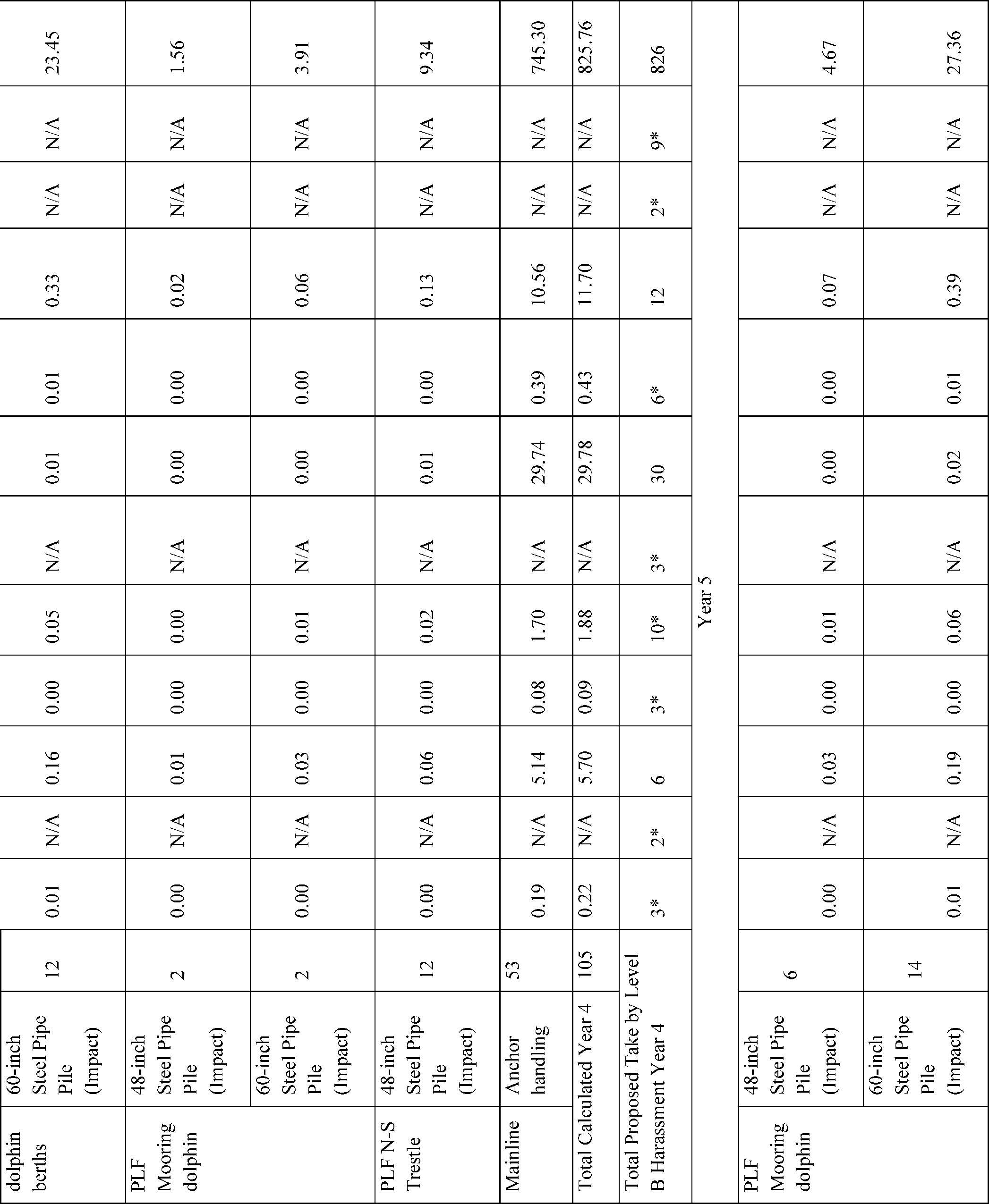
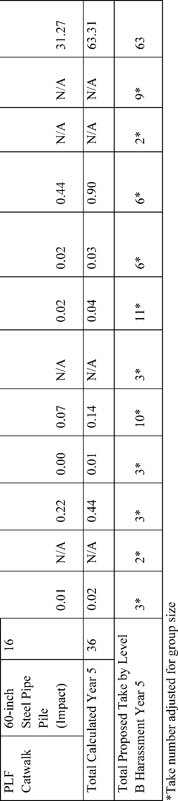
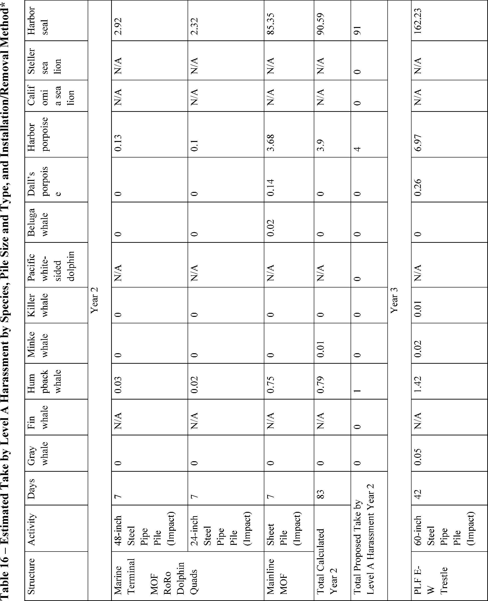
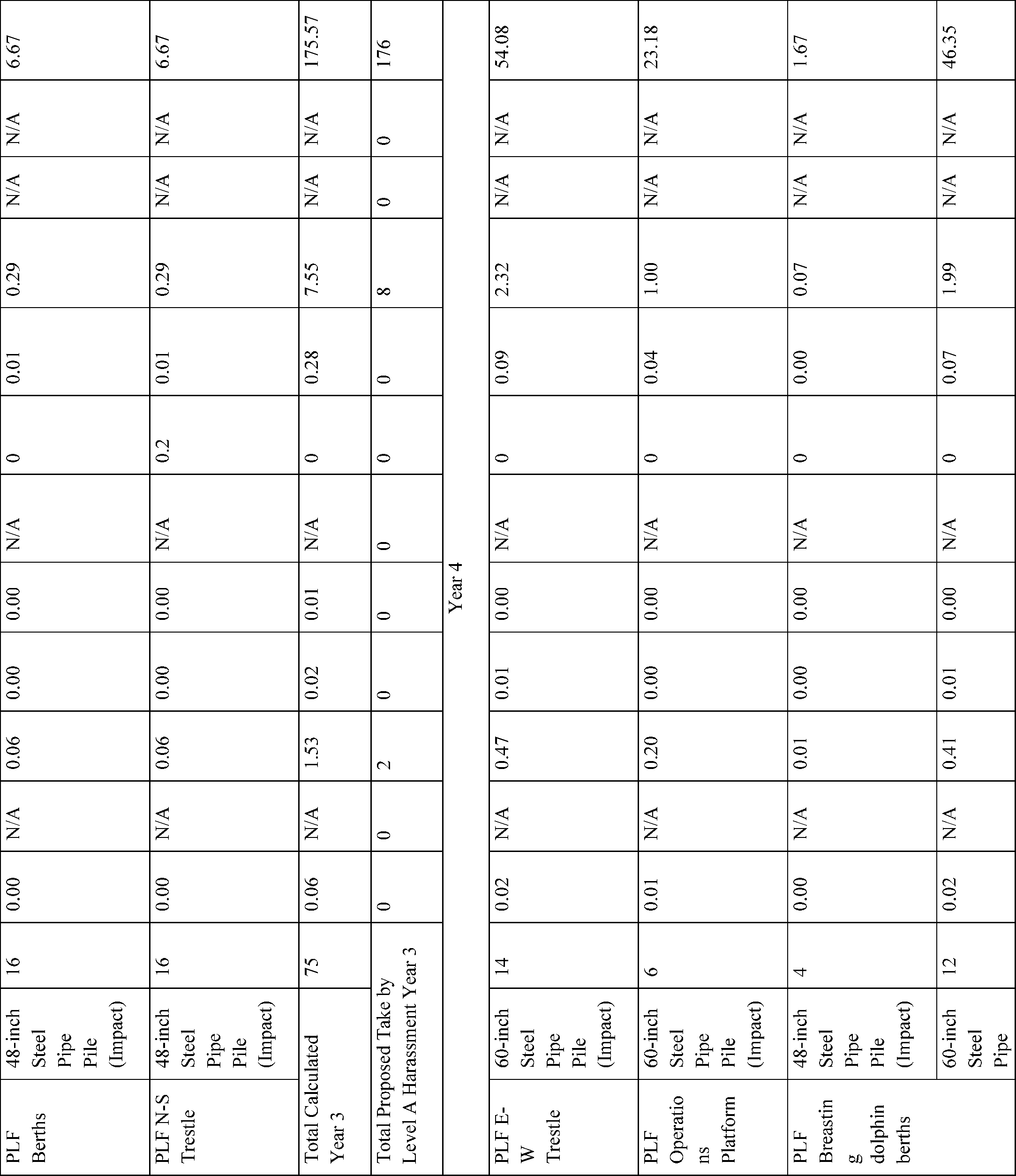
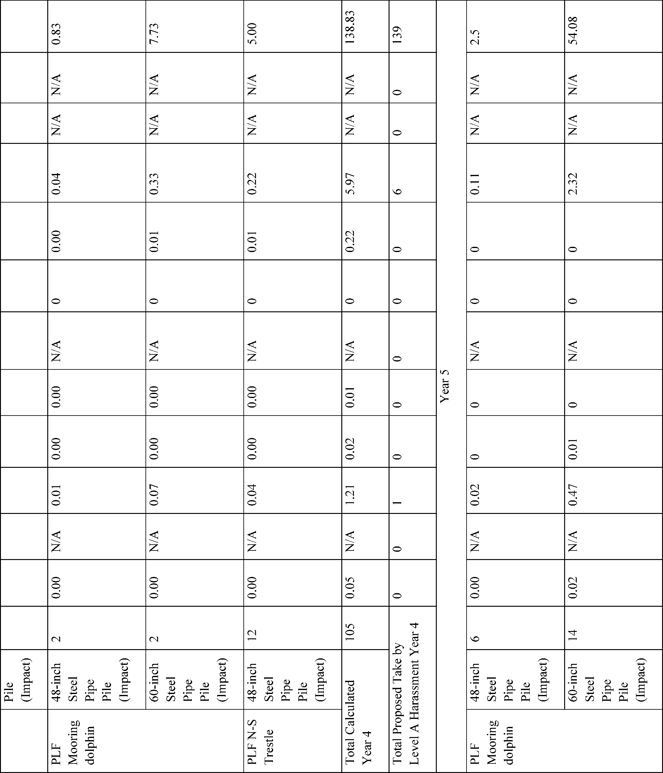
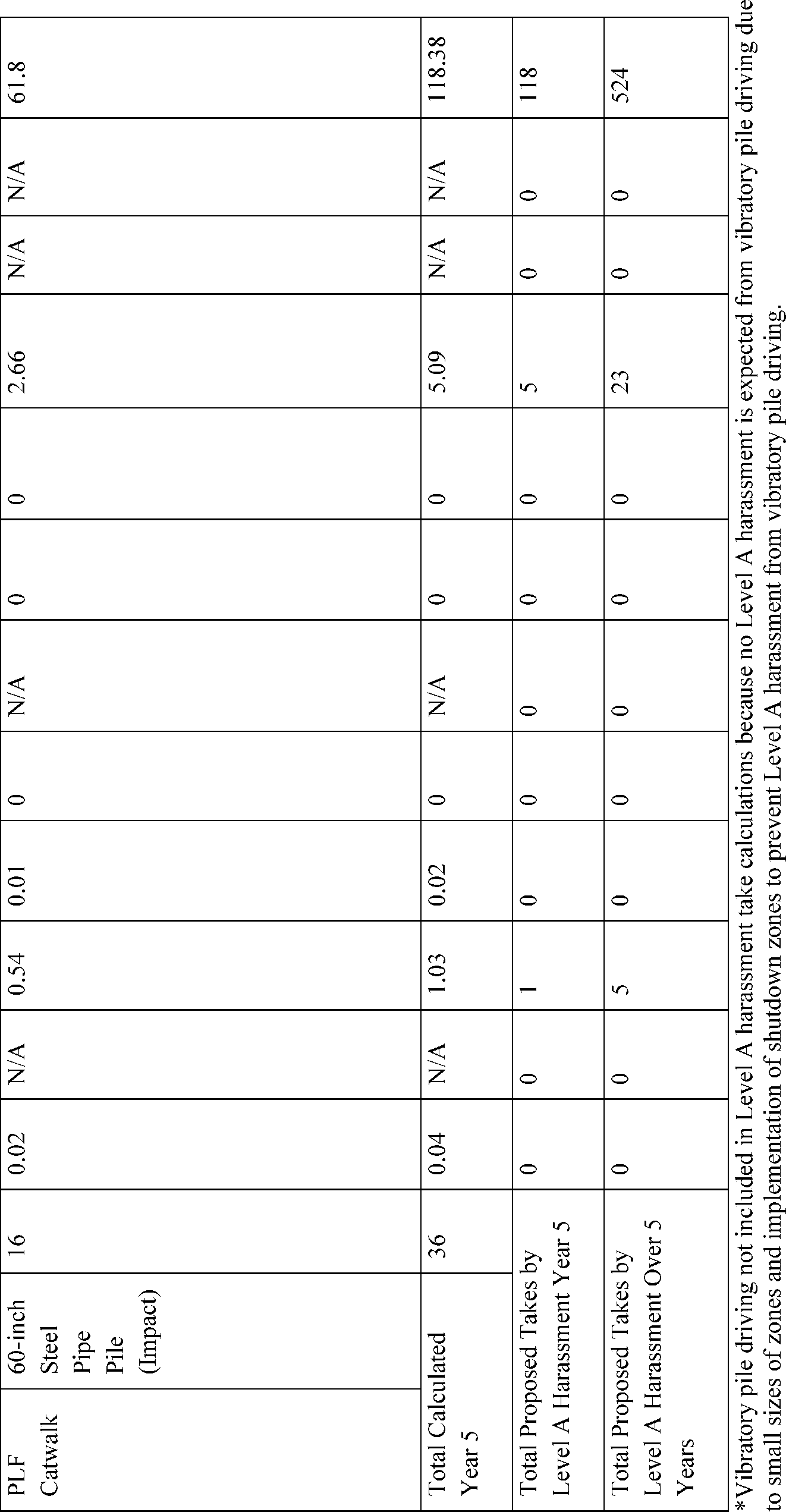
Takes of Marine Mammals Incidental to Specified Activities; Taking Marine Mammals Incidental to Alaska LNG Project in Cook Inlet
NMFS has received a request from 8 Star Alaska, LLC (8 Star Alaska), a subsidiary of Alaska Gasline Development Corporation (AGDC), for authorization to take marine mammals inci...
National Marine Fisheries Service (NMFS), National Oceanic and Atmospheric Administration (NOAA), Commerce.
ACTION:
Proposed rule; request for comments.
SUMMARY:
NMFS has received a request from 8 Star Alaska, LLC (8 Star Alaska), a subsidiary of Alaska Gasline Development Corporation (AGDC), for authorization to take marine mammals incidental to the Alaska Liquefied Natural Gas (LNG) Project in Cook Inlet, Alaska, over the course of 5 years (2026-2030). Pursuant to the Marine Mammal Protection Act (MMPA), NMFS proposes regulations setting forth permissible methods of taking, other means of effecting the least practicable adverse impact on such marine mammal stocks (
i.e.,
mitigation measures), and requirements pertaining to monitoring and reporting such takes, and requests comments on the proposed regulations. NMFS will consider public comments prior to making any final decision on the promulgation of the requested MMPA regulations, and NMFS' responses to public comments will be summarized in the final notification of our decision.
DATES:
Comments and information must be received no later than August 28, 2025.
ADDRESSES:
A plain language summary of this proposed rule is available at
https://www.regulations.gov/docket/NOAA-NMFS-2025-0141.
You may submit comments on this document, identified by NOAA-NMFS-2025-0141, by any of the following methods:
Electronic Submission:
Submit all electronic public comments via the Federal e-Rulemaking Portal. Visit
https://www.regulations.gov
and type NOAA-NMFS-2025-0141 in the Search box. Click on the “Comment” icon, complete the required fields, and enter or attach your comments.
Mail:
Submit written comments to the Permits and Conservation Division, Office of Protected Resources, National Marine Fisheries Service, 1315 East-West Highway, Silver Spring, MD 20910-3225.
Fax:
(301) 713-0376.
Instructions:
Comments sent by any other method, to any other address or individual, or received after the end of the comment period, may not be considered by NMFS. All comments received are a part of the public record and will generally be posted for public viewing on
https://www.regulations.gov
without change. All personal identifying information (
e.g.,
name, address,
etc.), confidential business information, or otherwise sensitive information submitted voluntarily by the sender will be publicly accessible. NMFS will accept anonymous comments (enter “N/A” in the required fields if you wish to remain anonymous).
Kristy Jacobus, Office of Protected Resources, NMFS, (301) 427-8401.
SUPPLEMENTARY INFORMATION:
Purpose and Need for Regulatory Action
NMFS received a request from 8 Star Alaska requesting 5-year regulations and a Letter of Authorization (LOA) that would authorize take of marine mammals by Level A and Level B harassment incidental to 8 Star Alaska's activities. No serious injury or mortality is anticipated or proposed to be authorized. Please see below for definitions of relevant terms and the Estimated Take of Marine Mammals section for definitions of harassment.
The proposed rule, promulgated under the authority of the MMPA (16 U.S.C. 1361et seq.), would provide a framework for authorizing the take of marine mammals incidental to construction activities associated with 8 Star Alaska's LNG project, including impact and vibratory pile driving and anchor handling.
Legal Authority for the Proposed Action
The MMPA prohibits the “take” of marine mammals, with certain exceptions. Section 101(a)(5)(A) and (D) of the MMPA (16 U.S.C. 1361et seq.) directs the Secretary of Commerce (as delegated to NMFS) to allow, upon request, the incidental, but not intentional, taking of small numbers of marine mammals by U.S. citizens who engage in a specified activity (other than commercial fishing) within a specified geographical region if certain findings are made, regulations are promulgated (when applicable), and public notice and an opportunity for public comment are provided.
Authorization for incidental takings shall be granted if NMFS finds that the taking will have a negligible impact on the species or stock(s) and will not have an unmitigable adverse impact on the availability of the species or stock(s) for taking for subsistence uses (where relevant). Further, NMFS must prescribe the permissible methods of taking and other “means of effecting the least practicable adverse impact” on the affected species or stocks and their habitat, paying particular attention to rookeries, mating grounds, and areas of similar significance, the availability of the species or stocks for taking for certain subsistence uses (referred to as “mitigation”), and requirements pertaining to the mitigation, monitoring and reporting of the takings are set forth.
As noted above, no serious injury or mortality is proposed to be authorized in this proposed rule. Relevant definitions of MMPA statutory and regulatory terms are included below:
Citizen
—individual U.S. citizens or any corporation or similar entity if it is organized under the laws of the United States or any governmental unit defined in 16 U.S.C. 1362(13) (50 CFR 216.103);
Take
—to harass, hunt, capture, or kill, or attempt to harass, hunt, capture, or kill any marine mammal (16 U.S.C. 1362; 50 CFR 216.3);
Incidental taking
—an accidental taking. This does not mean that the taking is unexpected, but rather it includes those takings that are infrequent, unavoidable, or accidental (50 CFR 216.103);
Serious injury
—any injury that will likely result in mortality (50 CFR 216.3);
Level A harassment
—any act of pursuit, torment, or annoyance which has the potential to injure a marine mammal or marine mammal stock in the wild (16 U.S.C. 1362); and
Level B harassment
—any act of pursuit, torment, or annoyance which has the potential to disturb a marine mammal or marine mammal stock in the wild by causing disruption of behavioral patterns, including, but not limited to, migration, breathing, nursing, breeding, feeding, or sheltering (16 U.S.C. 1362).
Section 101(a)(5)(A) of the MMPA and the implementing regulations at 50 CFR part 216, subpart I, provide the legal basis for proposing and, if appropriate, issuing 5-year regulations and
( printed page 35763)
associated LOA(s). This proposed rule also proposes required mitigation, monitoring, and reporting requirements for 8 Star Alaska's activities.
Summary of Major Provisions Within the Proposed Rule
The major provisions of this proposed rule include:
Allowing NMFS to authorize, through an LOA, the take of small numbers of marine mammals by Level A harassment and/or Level B harassment;
No mortality or serious injury of any marine mammal is proposed to be authorized;
Requiring NMFS-approved protected species observers (PSOs) and delaying commencement of or shutting down select activities should a marine mammal be detected within identified clearance or shutdown zones to minimize the amount and severity of take;
Requiring time/area closure for beluga whale during summer months in the western portion of Cook Inlet; and
Requiring soft start for impact pile driving to allow marine mammals the opportunity to leave the area prior to beginning impact pile driving at full power.
National Environmental Policy Act
To comply with the National Environmental Policy Act of 1969 (NEPA; 42 U.S.C. 4321et seq.) and NOAA Administrative Order 216-6A, NMFS must review our proposed action (
i.e.,
promulgation of regulations and subsequent issuance of a 5-year LOA) with respect to potential impacts on the human environment.
NMFS participated as a cooperating agency on the 2020 Alaska LNG Project Environmental Impact Statement (EIS), which was finalized on March 6, 2020, and is available at
https://www.ferc.gov/industries-data/natural-gas/environment/final-environmental-impact-statement-feis.
When acting as a cooperating agency, as is the case with this project, NMFS may satisfy its independent NEPA obligations by either preparing a separate NEPA analysis for its issuance of an incidental take authorization or, if appropriate, by adopting the NEPA analysis prepared by the lead agency. NMFS independently reviewed and evaluated the 2020 Alaska LNG Project EIS and determined it was adequate and sufficient to meet our responsibilities under NEPA for the issuance of the 2020 Alaska LNG Cook Inlet LOA (85 FR 59291, September 21, 2020). NMFS therefore adopted the 2020 Alaska LNG Project EIS and signed a Record of Decision on February 16, 2021.
Consistent with NEPA, applicable NOAA NEPA procedures, and the information and analysis contained in this proposed rule, NMFS has made a preliminary determination that this proposed rule and any subsequent LOAs would not result in significant impacts that were not fully considered in the 2020 Alaska LNG Project EIS. As indicated in this proposed rule, 8 Star Alaska has made no substantial changes to the activities evaluated in the EIS, and NMFS is unaware of any significant new circumstances or information relevant to environmental concerns or their impacts. NMFS will make a final NEPA determination prior to a decision whether to issue a final rule and LOA.
Fixing America's Surface Transportation Act
This project is covered under Title 41 of the Fixing America's Surface Transportation Act, or “FAST-41.” FAST-41 includes a suite of provisions designed to expedite the environmental review for covered infrastructure projects, including enhanced interagency coordination as well as milestone tracking on the public-facing Permitting Dashboard. FAST-41 also places a 2-year limitations period on any judicial claim that challenges the validity of a Federal agency decision to issue or deny an authorization for a FAST-41 covered project. 42 U.S.C. 4370m-6(a)(1)(A).
On December 5, 2024, NMFS received a request from 8 Star Alaska for regulations and a LOA to take marine mammals incidental to construction of LNG facilities in Cook Inlet, Alaska. Following NMFS' review of the application, 8 Star Alaska submitted a revised version on April 3, 2025, which was deemed adequate and complete. On April 8, 2025, NMFS published a notice of receipt (NOR) of application in the
Federal Register
(90 FR 15137), requesting comments and information during a 30-day public comment period related to 8 Star Alaska's request. NMFS received one letter from the Center for Biological Diversity and Cook Inletkeeper providing substantive comments and approximately 14,000 comments from members of the public expressing general opposition to 8 Star Alaska's proposed project but providing no information relevant to the information contained within 8 Star Alaska's application or to NMFS' determination that the application is adequate and complete. The comment letters from members of the public followed a generic template format in which respondents provided comments that were identical or substantively the same. NMFS has reviewed all submitted material and taken the information into consideration during the drafting of this proposed rule.
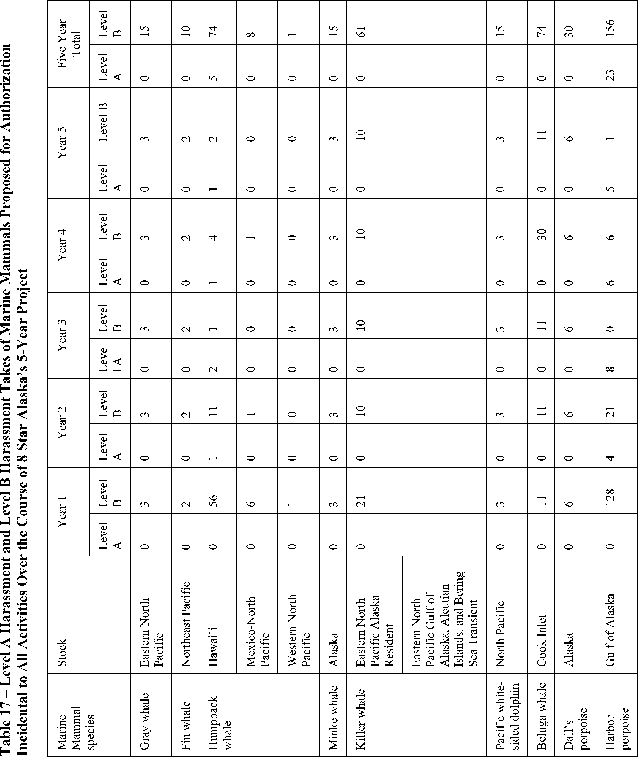
NMFS is proposing to authorize take of 12 species of marine mammals by Level B harassment, and by Level A harassment for a subset of 3 of these species. Neither 8 Star Alaska nor NMFS expect serious injury or mortality to result from the specified activities and neither are proposed to be authorized.
NMFS previously promulgated regulations and issued an LOA to AGDC for the same work on September 15, 2020 (85 FR 59291, September 21, 2020), effective from January 1, 2021, through December 31, 2025. However, no work has been conducted during the effective period of that LOA and none is planned prior to its expiration.
Description of Proposed Activity
Overview
8 Star Alaska proposes to construct facilities to transport and offload LNG in Cook Inlet, Alaska, for export. Project activities would include the construction of a Marine Terminal comprised of a temporary Marine Terminal Material Offloading Facility (MOF) and a permanent Product Loading Facility (PLF) on the east side of Cook Inlet, near Nikiski; construction of a pipeline (referred to as the Mainline) across Cook Inlet; and construction of a Mainline MOF on the west side of Cook Inlet, north of Tyonek. The components of the proposed construction activities that have the potential to expose marine mammals to sound levels that could result in take are vibratory and impact pile driving of steel sheet piles and 24-, 48-, 60-, and 66-inch (61-, 122-, 152.4-, and 167.6-centimer [cm]) steel pipe piles, as well as the use of anchor handling tugs (AHTs).
Dates and Duration
Planned in-water work would occur over 5 years between January 1, 2026, and December 31, 2030. The construction window is based on the ice-free working window, which is from approximately April 1 through October 31. Pile driving would occur during
( printed page 35764)
daylight hours and is estimated to occur 6 days per week. Work for pipelaying would occur 24 hours per day, 7 days per week, and could occur during periods of low visibility. In-water pile-driving is expected to occur over an estimated 323 nonconsecutive days over the 5-year period, and use of AHTs used for pipelaying in construction of the Mainline is expected to occur over an estimated 55 nonconsecutive days during Years 3 and 4 of the project, for a total of 378 construction days over the 5 year period (See table 1).
Table 1—Estimated Construction Schedule
Construction element
Estimated number of days
Year 1
Marine Terminal MOF
78
Year 2
Marine Terminal MOF
69
Mainline MOF
14
Year 3
PLF
74
Mainline
2
Year 4
Mainline
53
PLF
52
Year 5
PLF
36
Total
378
Specified Geographical Region
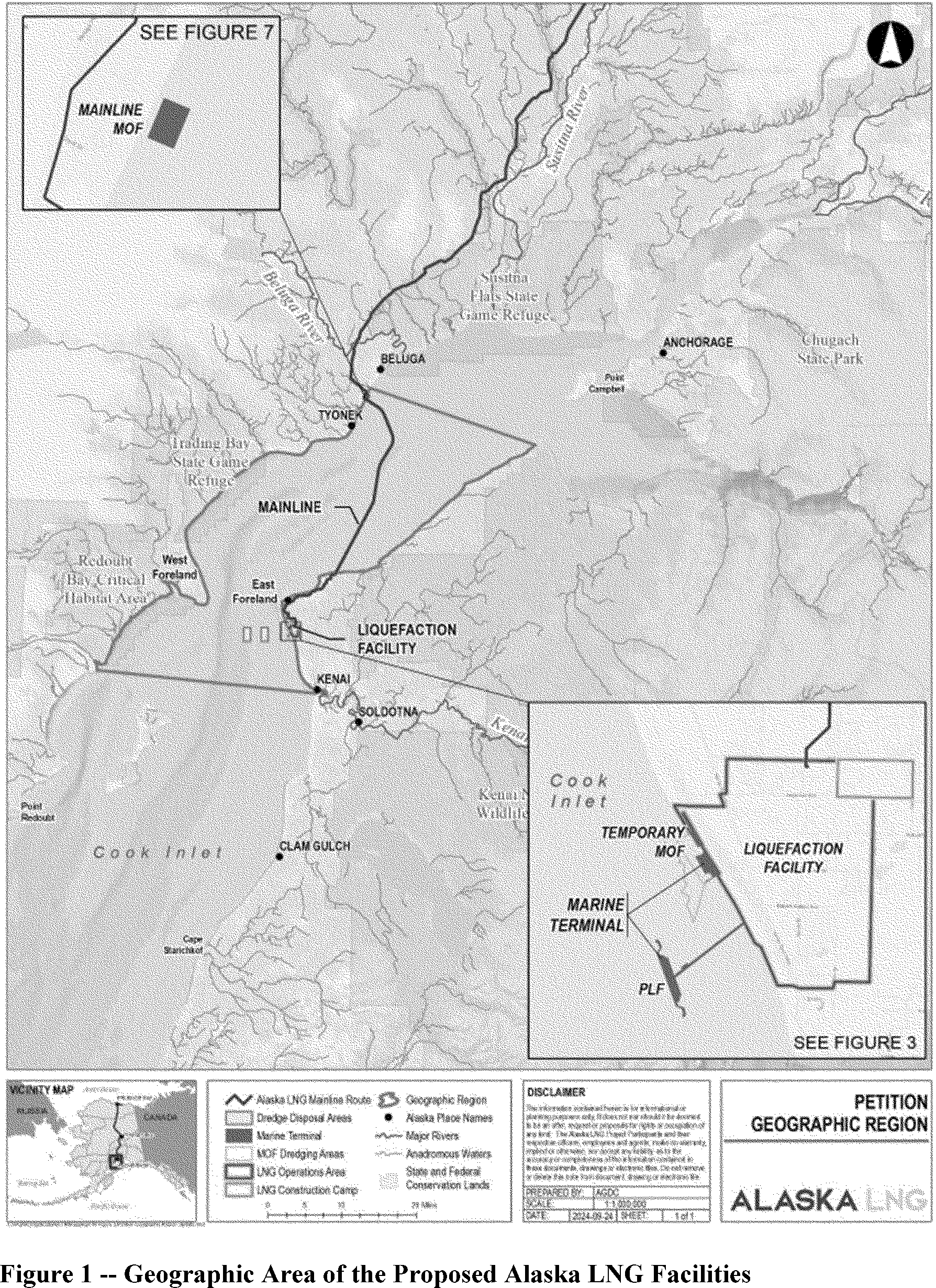
The proposed construction activities would occur in Cook Inlet, Alaska. The Marine Terminal, consisting of the temporary marine terminal MOF and PLF, would be constructed adjacent to the proposed onshore liquefaction facility near Nikiski, Alaska. The Mainline would cross the Cook Inlet shoreline on the west side of Cook Inlet south of Beluga Landing, traverse Cook Inlet in a generally southward direction for approximately 26.7 miles (43 kilometers [km]), and cross the east Cook Inlet shoreline near Suneva Lake. An MOF (Mainline MOF) may be constructed on the west side of Cook Inlet near the existing Beluga Landing to support installation of the Cook Inlet shoreline crossing. See figure 1 for a map of 8 Star Alaska's action area (see 8 Star Alaska's application for color legends).
( printed page 35765)
Detailed Description of the Specified Activity
Construction of the Alaska LNG facilities would include construction of a Marine Terminal, comprised of a temporary marine terminal MOF and PLF; a Mainline MOF; and a pipeline (referred to as Mainline) crossing Cook Inlet. Noise generated by impact and vibratory pile driving would be likely to result in take of marine mammals. Additionally, we assume here that noise generated by AHTs conducting anchor handling may result in take of marine mammals.
( printed page 35766)
Temporary Marine Terminal Material Offloading Facility
The temporary Marine Terminal MOF would consist of a quay and two berths, which would be used during construction of the Liquefaction Facility to enable direct deliveries of equipment modules, bulk materials, construction equipment, and other cargo to minimize the transport of large and heavy loads over road infrastructure. See Figure 6 in 8 Star Alaska's application for visual depiction of the Marine Terminal MOF. Construction of the Temporary MOF is expected to occur in Years 1 and 2.
Quay—The quay would be constructed of an outer wall consisting of combi-wall (combination of sheet pile and 66-inch steel pipe piles), tied back to a sheet pile anchor wall, and 11 sheet pile coffer cells, comprised of sheet piles and 24-inch pipe piles, backfilled with granular materials. The 24-inch pipe piles would be removed once coffer cell installation is complete. All pile installation and removal would be conducted with vibratory methods. 8 Star Alaska expects to use two crews during the installation of piles for the combi-wall and coffer cells, and therefore concurrent pile driving is expected to occur during installation of these features. This could result in concurrent vibratory pile driving of two 66-inch sheet piles, 2 sheet piles, 2 24-inch pile piles, a 66-inch pipe pile with a sheet pile, and a 24-inch pipe pile with a sheet pile. Installation of the sheet pile anchor wall is not considered in this analysis because the anchor wall would be installed into fill and would not generate substantial underwater sound.
Berths—Berths at the Marine Terminal MOF would include one Lift-on/Lift-off (Lo-Lo) berth and one Roll-on/Roll-off (Ro-Ro) berth maintained at depths alongside of 32 feet Mean Lower Low Water (MLLW). The berths would be constructed of 24-inch and 48-inch pipe piles using an impact hammer.
The Marine Terminal MOF would be constructed using both land-based (from shore and subsequently from constructed portions of the Marine Terminal MOF) and marine construction methods.
Dredging would be conducted at the Marine Terminal MOF with hydraulic or mechanical dredgers. While marine mammals may behaviorally respond in some small degree to the noise generated by dredging operations, given the slow, predictable movements of these vessels, and absent any other contextual features that would cause enhanced concern, NMFS does not consider it likely that 8 Star Alaska's proposed dredging would result in the take of marine mammals.
Product Loading Facility (PLF)
The proposed PLF would be a permanent facility used to load LNG carriers for export. The PLF would consist of two loading platforms, two berths, a marine operations platform, and an access trestle that supports the piping that delivers LNG from shore. See figure 4 in 8 Star Alaska's application for a visual description. In-water construction for the PLF would occur in Years 3-5. Construction methods would include both overhead construction (conducted with equipment located on a cantilever bridge extending from shore) and marine construction (conducted with equipment located on barges/vessels). All pile driving for the PLF would be conducted with an impact hammer. See figures 3 through 5 in 8 Star Alaska's application for visual depiction of the PLF.
PLF Berth Loading Platforms—The two loading platforms, located at either end of the north-south portion of the trestle would be supported above the seafloor on steel-jacketed structures called quadropods, made of 48-inch steel pipe piles.
PLF Berth Breasting and Mooring Dolphins—Each berth would have four concrete pre-cast breasting dolphins and six concrete pre-cast mooring dolphins that would be supported over the seabed on quadropods, comprised of 48-inch and 60-inch steel pipe piles. A catwalk, supported on two-pile bents comprised of 60-inch steel pipe piles, would connect the mooring dolphins to the loading platforms.
Marine Operations Platform—The platform would be located along the east-west portion of the access trestle and would be supported above the seafloor on four-pile bents, comprised of 60-inch steel pipe piles.
Access Trestle—The access trestle would be T-shaped with a long east-west oriented section and a shorter north-south oriented section. The east-west portion would be supported on three-pile and four-pile bents, comprised of 60-inch steel pipe piles, and the north-south oriented portion would be supported on five-pile quadropods, comprised of 48-inch steel pipe piles.
Mainline MOF
A Mainline MOF may be required on the west side of Cook Inlet to support installation of the Cook Inlet shoreline crossing. The Mainline MOF would consist of a quay, space for tugs, and berths including a Lo-Lo berth for unloading pipe and construction material and Ro-Ro berth and ramp dedicated to Ro-Ro operations. Approximately 1,270 feet (387.1 meters [m]) of sheet pile would be installed with a combination of vibratory and impact methods for construction of the quay and Ro-Ro ramp, and a corresponding length of sheet pile would be installed as anchor wall. However, only 670 feet (204.2 m) of sheet pile would be installed in the water, as the remainder would be installed as anchor wall in fill material or in the intertidal area when the tide is out. Therefore, only the installation of these 670 feet (204.2 m) of sheet pile is likely to result in the take of marine mammals. Construction of the Mainline MOF is expected to occur in Year 2.
Mainline Crossing Cook Inlet
8 Star Alaska proposes to install a 42-inch-diameter natural gas pipeline that would cross Cook inlet from the west side of the inlet south of Beluga Landing in a generally southward direction to the east side of Cook Inlet near Suneva Lake. The pipe would be trenched into the seafloor and buried from the shoreline out to a water depth of approximately 35-45 feet (10.7-13.7 m) MLLW on both sides of the inlet, approximately 8,800 feet from the north landfall and 6,600 feet from the south landfall. Burial depth in these areas would be 3-6 feet (0.9-1.8 m). Seaward of these sections, the pipeline would be placed on the seafloor. The installation methods would vary depending on the distance from shore, as described below. Installation of the Mainline crossing of Cook Inlet would include AHTs engaged in anchor handling (described further below). Construction of the Mainline is expected to occur during Years 3 and 4.
Pre-installation surveys—High-resolution geophysical surveys would be conducted prior to pipeline construction in order to develop a detailed bathymetric profile. The acoustic survey equipment proposed for use includes:
Single-beam echosounder operating at 200 kilohertz (kHz);
Multi-beam echosounder operating at 200-400 kHz;
Side-scan sonar system at 400-900 kHz; and
Magnetometer, which does not emit underwater sound.
The echosounders and side-scan sonar operate at or above 200 kHz, which are above the range of marine mammals' hearing thresholds, and the magnetometer does not emit sound. Therefore, use of this equipment is not expected to result in take of marine
( printed page 35767)
mammals, and it is not further evaluated in this proposed rule.
Nearshore Trenching, Pipelay, and Burial—In the nearshore portions of the route across Cook Inlet, the pipeline would be trenched and buried. The nearshore portion of the trench (extending from the shoreline to a transition water depth where a dredge vessel can be employed) would be constructed using amphibious or barge-based excavators. From the transition water depth to water depth of the −25 feet or −45 feet MLLW, 8 Star Alaska would use a dredge to excavate a trench for the pipeline. As described above, NMFS does not consider it likely that 8 Star Alaska's proposed dredging would result in the take of marine mammals.
Pipeline joints would be welded together onshore in 1,000 foot-long strings (pipe strings) and laid on the ground surface in an orientation that approximates the offshore alignment. 8 Star Alaska would anchor a pipe pull barge near the seaward end of the trench using AHTs. The barge would be used to pull the pipe strings from their onshore position into the trench. Given the transient and slow, predictable movement of barges, NMFS does not expect any potential for startle responses from individual marine mammals that may be in the vicinity. Similarly, with regard to the characteristics of noise output resulting from use of barges and other, similar industrial activities, NMFS generally assumes that the relative lack of variation in the signal and associated absence of high peak pressure or rapid rise time events (characteristics associated with impulsive and/or intermittent sound sources) significantly limits the likelihood of behavioral responses that might appropriately be considered take.
In addition to these general conclusions related to the physical and acoustic characteristics of the activity, NMFS considers contextual issues that may result in different, case-specific conclusions. For example, when considering relatively loud continuous noise sources, such as use of AHTs or tugging under load, NMFS evaluates the potential for exposure to result in take for sensitive species such as Cook Inlet beluga whales in important habitat is sufficient to justify a determination that some amount of take is likely. Following pipeline installation, the trench is expected to backfill naturally through the movement of seafloor sediments. If manual backfilling is required, the backfill would be placed by reversing the flow of the dredger used offshore or mechanically with the use of excavators.
Trenching, pipelay, and burial would be conducted 24 hours per day, seven days per week. 8 Star Alaska anticipates a pipelay rate of 2,000 (609.6 m) to 2,500 feet (762 m) per 24 hours. Anchor handling is only expected to occur during the initial anchoring of the pull barge, and therefore the AHTs are only expected to be used for a total of two days during nearshore pipelay, one day on the west coast near Beluga and one day on the east coast near Suneva Lake. We note here that AHT activities are not generally dissimilar from dredging, pipe-pulling, etc., in terms of the characteristics of noise output, although AHTs are assumed to be louder than these other similar activities. Given the slow, predictable, and generally straight path (or stationary nature) of tugs engaged in anchor handling activities, the likelihood of disrupting marine mammal behavioral patterns from tug use that would qualify as harassment under the MMPA is considered relatively low. Nevertheless, we have quantified the potential exposures from this activity, assumed that these exposures would equate to take, and analyzed the impacts of the assumed takes, which we propose for authorization. Anchor handling is the only activity assumed to result in take of marine mammals during the nearshore trenching, pipelay, and burial.
Offshore Pipeline Installation—Seaward of the trenched sections, the pipeline would be laid on the seafloor across Cook Inlet using conventional pipelay vessel methods. The pipelay vessel would likely employ 12 anchors to keep it positioned during pipelay and provide resistance as it is winched ahead 80 feet each time an additional 80-foot section of pipe is added/welded on the pipe string. 8 Star Alaska anticipates a pipelay rate of 2,000 to 2,500 feet (609.6-762 m) per 24 hours. 8 Star Alaska would use AHTs to reposition the anchors. Use of the AHTs could potentially result in take of marine mammals and is described in more detail below. Offshore pipelaying would be conducted for 24 hours per day, 7 days per week. 8 Star Alaska anticipates using AHTs about 25 percent of the time (
i.e.,
approximately 6 hours per day).
AHTs—8 Star Alaska would use AHTs and anchor systems to maintain the optimal stability and alignment of a specialized vessel, referred to as a pipelay barge, while laying pipeline on the seafloor. Pipeline activities utilizing pipelay barge methods include support from up to three AHTs that would repeatedly reposition the anchors, thereby maintaining proper position and permitting forward movement.
8 Star Alaska is unable to specify tugging characteristics at this time. However, based on specifications for other similar activities such as Hilcorp Alaska's LLC's Production Drilling Support Activities in Cook Inlet (89 FR 79529; September 30, 2024) and Furie Operating Alaska, LLC Natural Gas Activities in Cook Inlet (89 FR 77836; September 24, 2024), NMFS anticipates that the AHTs would be rated between 4,000 horsepower (hp) and 8,000 hp. Potential tug power output during anchor handling is discussed in further detail in the Estimated Take of Marine Mammals section.
A summary of pile driving activities for the Alaska LNG facilities construction is provided in table 2, and a summary of the use of AHTs for pipelaying is provided in table 3.
Number of steel pipe piles or length of sheet piles
Hammer type
# days
24-inch steel pipe
48-inch steel pipe
60-inch steel pipe
66-inch steel pipe
Sheet piles
Year 1
Marine Terminal MOF
Combi-wall
70
144
Vibratory
22
Marine Terminal MOF
Coffer cell
48
1,496
Vibratory
56
Year 2
Marine Terminal MOF
Coffer cell
40
1,491
Vibratory
54
Marine Terminal MOF
Ro-Ro/Lo-Lo berths
7
28
Impact
14
Mainline MOF
Quay
205
Vibratory/Impact
10
( printed page 35768)
Mainline MOF
Ro-Ro ramp
87
Vibratory/Impact
4
Year 3
PLF
E-W Trestle
73
Impact
42
PLF
Berth Loading Platforms
40
Impact
16
PLF
N-S Trestle
40
Impact
16
Year 4
PLF
E-W Trestle
28
Impact
14
PLF
Operations Platform
12
Impact
6
PLF
Breasting Dolphin
8
32
Impact
16
PLF
Mooring Dolphin
2
8
Impact
4
PLF
N-S Trestle
30
Impact
12
Year 5
PLF
Mooring Dolphin
10
40
Impact
20
PLF
Catwalk
8
Impact
16
Total
73
158
236
70
3,423
323
Table 3—Schedule of Anchor Handling for Construction of Mainline Across Cook Inlet
Activity
Hours/day
Days
Year 3
Nearshore pipelay
6
2
Year 4
Offshore pipelay
6
53
Proposed mitigation, monitoring, and reporting measures are described in detail later in this document (please see Proposed Mitigation and Proposed Monitoring and Reporting).
Description of Marine Mammals in the Area of Specified Activities
Sections 3 and 4 of the application summarize available information regarding status and trends, distribution and habitat preferences, and behavior and life history of the potentially affected species. NMFS fully considered all of this information, and we refer the reader to these descriptions instead of reprinting the information. Additional information regarding population trends and threats may be found in NMFS' Stock Assessment Reports (SARs;
https://www.fisheries.noaa.gov/national/marine-mammal-protection/marine-mammal-stock-assessments) and more general information about these species (
e.g.,
physical and behavioral descriptions) may be found on NMFS' website (
https://www.fisheries.noaa.gov/find-species).
Table 4 lists all species or stocks for which take is expected and proposed to be authorized for this activity and summarizes information related to the population or stock, including regulatory status under the MMPA and Endangered Species Act (ESA) and potential biological removal (PBR), where known. PBR is defined by the MMPA as the maximum number of animals, not including natural mortalities, that may be removed from a marine mammal stock while allowing that stock to reach or maintain its optimum sustainable population (as described in NMFS' SARs). While no serious injury or mortality is anticipated or proposed to be authorized here, PBR and annual serious injury and mortality (M/SI) from anthropogenic sources are included here as gross indicators of the status of the species or stocks and other threats.
Marine mammal abundance estimates presented in this document represent the total number of individuals that make up a given stock or the total number estimated within a particular study or survey area. NMFS' stock abundance estimates for most species represent the total estimate of individuals within the geographic area, if known, that comprises that stock. For some species, this geographic area may extend beyond U.S. waters. All managed stocks in this region are assessed in NMFS' U.S. Alaska and Pacific SARs. All values presented in table 4 are the most recent available at the time of publication (including from the draft 2024 SARs) and are available online at:
https://www.fisheries.noaa.gov/national/marine-mammal-protection/marine-mammal-stock-assessments.
Table 4—Species 1
With Estimated Take From the Specified Activities
Common name
Scientific name
Stock
ESA/
MMPA
status;
Strategic
(Y/N) 2
Stock abundance (CV, N
min
, most recent abundance
survey) 3
PBR
Annual M/SI 4
Order Artiodactyla—Cetacea—Mysticeti (baleen whales)
Family Eschrichtiidae:
Gray Whale
Eschrichtius robustus
Eastern North Pacific
-, -, N
26,960 (0.05, 25,849, 2016)
801
131
Family Balaenopteridae (rorquals):
Fin Whale
Balaenoptera physalus
Northeast Pacific
E, D, Y
11,065 (0.405 7,970, 2013) 5
UND
0.6
Humpback Whale
Megaptera novaeangliae
Hawai'i
-, -, N
11,278 (0.56, 7,265, 2020)
127
27.09
Humpback Whale
Megaptera novaeangliae
Mexico-North Pacific
T, D, Y
N/A 6
(N/A, N/A, 2006)
UND
0.57
( printed page 35769)
Humpback Whale
Megaptera novaeangliae
Western North Pacific
E, D, Y
1,084 (0.088, 1,007, 2006)
3.4
5.82
Minke Whale
Balaenoptera acutorostrata
Alaska
-, -, N
N/A 7
(N/A, N/A, N/A)
UND
0
Odontoceti (toothed whales, dolphins, and porpoises)
Family Delphinidae:
Killer Whale
Orcinus orca
Eastern North Pacific Alaska Resident
-, -, N
1,920 (N/A, 1,920, 2019)
19
1.3
Killer Whale
Orcinus orca
Eastern North Pacific Gulf of Alaska, Aleutian Islands and Bering Sea Transient
2
Endangered Species Act (ESA) status: Endangered (E), Threatened (T)/MMPA status: Depleted (D). A dash (-) indicates that the species is not listed under the ESA or designated as depleted under the MMPA. Under the MMPA, a strategic stock is one for which the level of direct human-caused mortality exceeds PBR or which is determined to be declining and likely to be listed under the ESA within the foreseeable future. Any species or stock listed under the ESA is automatically designated under the MMPA as depleted and as a strategic stock.
4
These values, found in NMFS' SARs, represent annual levels of human-caused mortality plus serious injury from all sources combined (
e.g.,
commercial fisheries, ship strike). Annual M/SI often cannot be determined precisely and is in some cases presented as a minimum value or range.
5
The best available abundance estimate for this stock is not considered representative of the entire stock as surveys were limited to a small portion of the stock's range.
6
NMFS's abundance estimate for this stock is greater than eight years old and not considered current. PBR is therefore considered undetermined for this stock, as there is no current minimum abundance estimate for use in calculation. We nevertheless present the most recent abundance estimate as the best available information.
7
Reliable population estimates are not available for this stock.
8
The best available abundance estimate is likely an underestimate for the entire stock because it is based upon a survey that covered only a small portion of the stock's range.
9
Nest is best estimate of counts, which have not been corrected for animals at sea during abundance surveys. Estimates provided are for the U.S. only. The overall N
min
is 73,211 and overall PBR is 439.
As indicated above, all 12 species (with 15 managed stocks) in table 4 temporally and spatially co-occur with the activity to the degree that take is reasonably likely to occur.
In addition, the northern sea otter may be found in Cook Inlet, Alaska. However, northern sea otters are managed by the U.S. Fish and Wildlife Service and are not considered further in this document.
Gray Whale
The stock structure for gray whales in the Pacific has been studied for a number of years and remains uncertain as of the most recent draft 2024 Pacific SARs (Carretta
et al.,
2025). Gray whale population structure is not determined by simple geography and may be in flux due to evolving migratory dynamics (Carretta
et al.,
2024). Currently, the SARs delineate a western North Pacific (WNP) gray whale stock and an eastern North Pacific (ENP) stock based on genetic differentiation (Carretta
et al.,
2025). WNP gray whales are not known to feed in or travel to upper Cook Inlet (Conant and Lohe, 2023, Weller
et al.,
2023). Therefore, we assume that gray whales near the project area are members of the ENP stock.
An Unusual Mortality Event (UME) for gray whales along the West Coast and in Alaska occurred from December 17, 2018, through November 9, 2023. During that time 690 gray whales stranded in the United States, Mexico, and Canada, 146 of which stranded off the coast of Alaska. The investigative team concluded that the preliminary cause of the UME was localized ecosystem changes in the whale's Subarctic and Arctic feeding areas that led to changes in food, malnutrition, decreased birth rates, and increased mortality (see
https://www.fisheries.noaa.gov/national/marine-life-distress/2019-2023-gray-whale-unusual-mortality-event-along-west-coast-and
for more information).
Gray whales occur infrequently in Cook Inlet, but may be seasonally present during spring and fall in the lower inlet (Bureau of Ocean Energy Management (BOEM), 2022). Migrating gray whales pass through the lower inlet during their spring and fall migrations to and from their primary summer feeding areas in the Bering, Chukchi, and Beaufort seas (Swartz, 2018, Silber
et al.,
2021, Bureau of Ocean Energy Management (BOEM), 2022). Several surveys and monitoring programs have sighted gray whales in lower Cook Inlet (Shelden
et al.,
2013, Owl Ridge, 2014, Lomac-MacNair
et al.,
2013, 2014,
( printed page 35770)
Kendall
et al.,
2015). Gray whales are occasionally seen in mid- and upper Cook Inlet, Alaska, but they are not common. During NMFS aerial surveys conducted in June 1994, 2000, 2001, 2005, and 2009, gray whales were observed in Cook Inlet near Port Graham and Elizabeth Island as well as near Kamishak Bay, with one gray whale observed as far north as the Beluga River (Shelden
et al.,
2013). Gray whales were also observed offshore of Cape Starichkof in 2013 by marine mammal observers monitoring Buccaneer's Cosmopolitan drilling project (Owl Ridge, 2014) and in middle Cook Inlet in 2014 during the 2014 Apache 2D seismic survey (Lomac-MacNair
et al.,
2015). Several projects performed in Cook Inlet in recent years reported no observations of gray whales. These project activities included the SAExploration seismic survey in 2015 (Kendall and Cornick, 2015), the 2018 Cook Inlet Pipeline (CIPL) Extension Project (Sitkiewicz
et al.,
2018), and the 2019 Hilcorp seismic survey in lower Cook Inlet (Fairweather Science, 2020).
In 2020, during the aforementioned UME, a young male gray whale was stranded in the Twentymile River near Girdwood for over a week before swimming back into Turnagain Arm. The whale did not survive and was found dead in west Cook Inlet later that month (NMFS, 2020). One gray whale was sighted in Knik Arm near the Port of Alaska (POA) in Anchorage in upper Cook Inlet in May of 2020 during observations conducted during construction of the Petroleum and Cement Terminal project (61 North Environmental, 2021). The sighting occurred less than a week before the reports of the gray whale stranding in the Twentymile River and was likely the same animal. In 2021, one small gray whale was sighted in Knik Arm near Ship Creek, south of the POA (61 North Environmental, 2022a). Although some sightings have been documented in the middle and upper Inlet, the gray whale range typically only extends into the lower Cook Inlet region.
Humpback Whale
The most comprehensive photo-identification data available suggest that approximately 89 percent of all humpback whales in the Gulf of Alaska are from the Hawaii stock, 11 percent are from the Mexico stock, and less than 1 percent are from the Western North Pacific stock (Wade, 2021). Individuals from different stocks are known to intermix in feeding grounds. There is no designated critical habitat for humpback whales in or near the area where the specified activity is planned to occur (86 FR 21082, April 21, 2021), nor does the project overlap with any known biologically important areas (Wild
et al.,
2023).
Humpback whales are encountered regularly in lower Cook Inlet and occasionally in mid-Cook Inlet; sightings are rare in upper Cook Inlet. Eighty-three groups containing an estimated 187 humpbacks were sighted during Cook Inlet beluga whale aerial surveys conducted by NMFS from 1994 to 2012 (Shelden
et al.,
2013). Surveys conducted north of the forelands have documented small numbers in middle Cook Inlet. During the 2014 Apache seismic surveys in Cook Inlet, five groups (six individuals) were reported, with three groups north of the forelands on the east side of the inlet (Lomac-MacNair
et al.,
2014). In 2015, during the construction of the Furie Operating Alaska, LLC (Furie) platform and pipeline, four groups of humpback whales were documented. Another group of 6 to 10 unidentified whales, thought to be either humpback or gray whales, was sighted approximately 15 km northeast of the Julius R. Platform Large cetaceans were visible near the project (
i.e.,
whales or blows were visible) for 2 hours out of the 1,275 hours of observation conducted (Jacobs Engineering Group Inc., 2015).
Minke Whale
No estimates have been made for the number of minke whales in the entire North Pacific (Young
et al.,
2024). However, some information is available on the number of minke whales in some areas of Alaska. Visual surveys for cetaceans were conducted on the eastern Bering Sea shelf in 2002, 2008, and 2010 in cooperation with research on commercial fisheries (Friday
et al.,
2013). Results of the surveys in 2002, 2008, and 2010 provided provisional abundance estimates of 389 (CV−0.52), 517 (CV = 0.69), and 2,020 (CV = 0.73) minke whales on the eastern Bering Sea shelf, respectively (Friday
et al.,
2013). These estimates are considered provisional because they have not been corrected for animals missed on the trackline, animals submerged when the ship passed, or responsive movement. Additionally, line transect surveys were conducted in shelf and nearshore waters (within 30-45 nautical miles of land) in 2001-2003 from the Kenai Fjords in the Gulf of Alaska to the central Aleutian Islands. Minke whale abundance was estimated to be 1,233 (CV = 0.34) for this area (Zerbini
et al.,
2006). This estimate has also not been corrected for animals missed on the trackline. The majority of the sightings were in the Aleutian Islands, rather than in the Gulf of Alaska, and in water shallower than 200 m. So few minke whales were seen during three offshore Gulf of Alaska surveys for cetaceans in 2009, 2013, and 2015 that a population estimate for the species in this area could not be determined (Rone
et al.,
2017). These estimates cannot be used as an estimate of the entire Alaska stock of minke whales because only a portion of the stock's range was surveyed (Young
et al.,
2024).
Minke whales are most abundant in the Gulf of Alaska during summer and occupy localized feeding areas (Zerbini
et al.,
2006). During the NMFS annual and semiannual surveys of Cook Inlet, minke whales were observed near Anchor Point in 1998, 1999, 2006, and 2021 (Shelden
et al.,
2013, 2015b, 2017, 2022, Shelden and Wade, 2019) and near Ninilchik and the middle of lower Cook Inlet in 2021 (Shelden
et al.,
2022). Minke whales were sighted southeast of Kalgin Island and near Homer during Apache's 2014 survey (Lomac-MacNair
et al.,
2014), and one was observed near Tuxedni Bay in 2015 (Kendall
et al.,
2015 as cited in Weston and SLR 2022). During Hilcorp's seismic survey in lower Cook Inlet in the fall of 2019, eight minke whales were observed (Fairweather Science, 2020). In 2018, no minke whales were observed during observations conducted for the CIPL project near Tyonek (Sitkiewicz
et al.,
2018). Minke whales were also not recorded during Hilcorp's aerial or rig-based monitoring efforts in 2023 (Horsley and Larson, 2023).
Fin Whale
Fin whales' range extends into lower Cook Inlet; however, sightings are infrequent, and they are mostly spotted near the Inlet's entrance. Fin whales are usually observed as individuals traveling alone, although they are sometimes observed in small groups. From 2000 to 2022, 10 sightings of 26 estimated individual fin whales were observed in lower Cook Inlet during NMFS aerial surveys (Shelden
et al.,
2013, 2015b, 2017, 2022, Shelden and Wade, 2019). In the fall of 2019 during Hilcorp's seismic survey in lower Cook Inlet, 8 sightings of 23 fin whales were documented, suggesting greater numbers may use the area in the fall than previously estimated (Fairweather Science, 2020). Hilcorp did not record any sightings of fin whales from their aerial or rig-based monitoring efforts in 2023 (Horsley and Larson, 2023).
Beluga Whale
Five stocks of beluga whales are recognized in Alaska: the Beaufort Sea stock, eastern Chukchi Sea stock,
( printed page 35771)
eastern Bering Sea stock, Bristol Bay stock, and Cook Inlet stock (Young
et al.,
2023). The Cook Inlet stock of beluga whale is the only stock that inhabits the project area. It is geographically and genetically isolated from the other stocks (O'Corry-Crowe
et al.,
1997, Laidre
et al.,
2000) and resides year-round in Cook Inlet (Laidre
et al.,
2000, Castellote
et al.,
2020). Cook Inlet beluga whales (CIBWs) were designated as depleted under the MMPA in 2000 (65 FR 34950, May 31, 2000), and as a distinct population segment (DPS) and listed as endangered under the ESA in October 2008 (73 FR 62919, October 10, 2008) when the species failed to recover following a moratorium on subsistence harvest. Between 2008 and 2018, CIBWs experienced a decline of about 2.3 percent per year (Wade
et al.,
2019). The decline overlapped with the northeast Pacific marine heatwave that occurred from 2014 to 2016 in the Gulf of Alaska, significantly impacting the marine ecosystem (Suryan
et al.,
2021 as cited in Goetz
et al.,
2023).
In June 2023, NMFS released an updated abundance estimate for CIBWs in Alaska that incorporates aerial survey data from June 2021 and 2022 and accounted for visibility bias (Goetz
et al.,
2023). This report estimated that CIBW abundance is between 290 and 386, with a median best estimate of 331. Goetz
et al.
(2023) also present an analysis of population trends for the most recent 10-year period (2012-2022). The addition of data from the 2021 and 2022 survey years in the analysis resulted in a 65.1 percent probability that the CIBW population is now increasing at 0.9 percent per year (95 percent prediction interval of −3 to 5.7 percent). This increase drops slightly to 0.2 percent per year (95 percent prediction interval of −1.8 to 2.6 percent) with a 60 percent probability that the CIBW population is increasing more than 1 percent per year when data from 2021, which had limited survey coverage due to poor weather, are excluded from the analysis.
Threats that have the potential to impact this stock and its habitat include the following: changes in prey availability due to natural environmental variability, ocean acidification, and commercial fisheries; climatic changes affecting habitat; predation by killer whales; contaminants; noise; ship strikes; waste management; urban runoff; construction projects; and physical habitat modifications that may occur as Cook Inlet becomes increasingly urbanized (Moore
et al.,
2000, Hobbs
et al.,
2015, NMFS, 2016). Another source of CIBW mortality in Cook Inlet is predation by transient-type (mammal-eating) killer whales (NMFS, 2016, Shelden
et al.,
2003). No human-caused mortality or serious injury of CIBWs through interactions with commercial, recreational, and subsistence fisheries, takes by subsistence hunters, and or human-caused events (
e.g.,
entanglement in marine debris, ship strikes) has been recently documented (Muto
et al.,
2022) and harvesting of CIBWs has not occurred since 2008 (NMFS, 2008a).
Recovery Plan
In 2010, a recovery team, consisting of a science panel and stakeholder panel, began meeting to develop a recovery plan for the CIBW. The final recovery plan was published in the
Federal Register
on January 5, 2017 (82 FR 1325). In September 2022, NMFS completed the ESA 5-year review for the CIBW DPS and determined that the CIBW DPS should remain listed as endangered (NMFS, 2022a).
In its recovery plan (82 FR 1325, January 5, 2017), NMFS identified several potential threats to CIBWs, including: (1) high concern: catastrophic events (
e.g.,
natural disasters, spills, mass strandings), cumulative effects of multiple stressors, and noise; (2) medium concern: disease agents (
e.g.,
pathogens, parasites, and harmful algal blooms), habitat loss or degradation, reduction in prey, and unauthorized take; and (3) low concern: pollution, predation, and subsistence harvest. The recovery plan did not treat climate change as a distinct threat but rather as a consideration in the threats of high and medium concern. Other potential threats most likely to result in direct human-caused mortality or serious injury of this stock include vessel strikes.
Critical Habitat
On April 11, 2011, NMFS designated two areas of critical habitat for CIBW (76 FR 20179). The designation includes 7,800 square kilometers (km2
) of marine and estuarine habitat within Cook Inlet, encompassing approximately 1,909 km2
in Area 1 and 5,891 km2
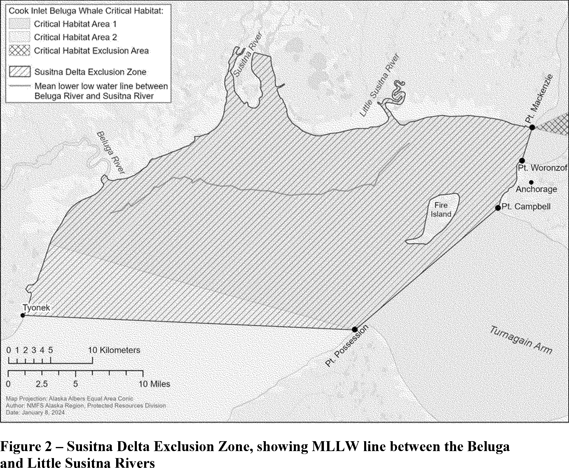
in Area 2 (see figure 1 in 76 FR 20179). Area 1 of the CIBW critical habitat encompasses all marine waters of Cook Inlet north of a line connecting Point Possession (lat. 61.04° N, long. 150.37° W) and the mouth of Three Mile Creek (lat. 61.08.55° N, long. 151.04.40° W), including waters of the Susitna, Little Susitna, and Chickaloon Rivers below Mean Higher High Water (MHHW). From spring through fall, Area 1 critical habitat has the highest concentration of CIBWs due to its important foraging and calving habitat. Critical Habitat Area 2, where 8 Star Alaska's proposed construction activities would occur, encompasses some of the fall and winter feeding grounds in middle Cook Inlet. This area has a lower concentration of CIBWs in spring and summer but is used by CIBWs in fall and winter. More information on CIBW critical habitat can be found at
https://www.fisheries.noaa.gov/action/critical-habitat-cook-inlet-beluga-whale.
The designation identified the following Primary Constituent Elements, essential features important to the conservation of the CIBW:
(1) Intertidal and subtidal waters of Cook Inlet with depths of less than 9 m Mean Lower Low Water (MLLW) and within 8 km of high- and medium-flow anadromous fish streams;
(2) Primary prey species, including four of the five species of Pacific salmon (chum (
Oncorhynchus keta), sockeye (
Oncorhynchus nerka), Chinook (
Oncorhynchus tshawytscha), and coho (
Oncorhynchus kisutch)), Pacific eulachon (
Thaleichthys pacificus), Pacific cod (
Gadus macrocephalus), walleye Pollock (
Gadus chalcogrammus), saffron cod (
Eleginus gracilis), and yellowfin sole (
Limanda aspera)
;
(3) The absence of toxins or other agents of a type or amount harmful to CIBWs;
(4) Unrestricted passage within or between the critical habitat areas; and
(5) The absence of in-water noise at levels resulting in the abandonment of habitat by CIBWs.
Biologically Important Areas
Wild
et al.
(2023) delineated a small and resident population Biologically Important Area (BIA) in Cook Inlet that is active year-round and overlaps 8 Star Alaska's proposed project area. The authors assigned the BIA an importance score of 2, an intensity score of 2, a data support score of 3, and a boundary certainty score of 2 (scores range from 1 to 3, with a higher score representing an area of more concentrated or focused use and higher confidence in the data supporting the BIA (Harrison
et al.,
2023)). These scores indicate that the BIA is of moderate importance and intensity, the authors have high confidence that the population is small and resident and in the abundance and range estimates of the population, and the boundary certainty is medium (see Harrison
et al.
(2023) for additional information about the scoring process used to identify BIAs). The boundary of the CIBW BIA is consistent with NMFS' critical habitat designation (Wild
et al.,
2023).
( printed page 35772)
Ecology
Generally, female beluga whales reach sexual maturity at 9 to 12 years old, while males reach maturity later (O'Corry‐Crowe, 2009); however, this can vary between populations. For example, in Greenland, males in a population of beluga whales were found to reach sexual maturity at 6 to 7 years of age and females at 4 to 7 years (Heide-Jørgensen and Teilmann, 1994). Suydam (2009) estimated that 50 percent of females were sexually mature at age 8.25 and the average age at first birth was 8.27 years for belugas sampled near Point Lay. Mating behavior in beluga whales typically occurs between February and June, peaking in March (Burns and Seaman, 1986, Suydam, 2009). In the Chukchi Sea, the gestation period of beluga whales was determined to be 14.9 months, with a calving interval of 2 to 3 years and a pregnancy rate of 0.41, declining after 25 years of age (Suydam, 2009). Calves are born between mid-June and mid-July and typically remain with the mother for up to 2 years of age (Suydam, 2009).
CIBWs feed on a wide variety of prey species, particularly those that are seasonally abundant. From late spring through summer, most CIBW stomachs sampled contained salmon, which corresponded to the timing of fish runs in the area. Anadromous smolt and adult fish aggregate at river mouths and adjacent intertidal mudflats (Calkins, 1989). All five Pacific salmon species (
i.e.,
Chinook, pink (
Oncorhynchus gorbuscha), coho, sockeye, and chum) spawn in rivers throughout Cook Inlet (Moulton, 1997, Moore
et al.,
2000). Overall, Pacific salmon represent the highest percent frequency of occurrence of prey species in CIBW stomachs. This suggests that their spring feeding in upper Cook Inlet, principally on fat-rich fish such as salmon and eulachon, is important to the energetics of these animals (NMFS, 2016).
The nutritional quality of Chinook salmon in particular is unparalleled, with an energy content four times greater than that of a Coho salmon. It is suggested the decline of the Chinook salmon population has left a nutritional void in the diet of the CIBWs that no other prey species can fill in terms of quality or quantity (Norman
et al.,
2022, Norman
et al.,
2020).
In fall, as anadromous fish runs begin to decline, CIBWs return to consume fish species (cod and bottom fish) found in nearshore bays and estuaries. Stomach samples from CIBWs are not available for winter (December through March), although dive data from CIBWs tagged with satellite transmitters suggest that they feed in deeper waters during winter (Hobbs
et al.,
2005), possibly on such prey species as flatfish, cod, sculpin, and pollock.
Distribution in Cook Inlet
The CIBW stock remains within Cook Inlet throughout the year, showing only small seasonal shifts in distribution (Goetz
et al.,
2012a, Lammers
et al.,
2013, Castellote
et al.,
2015, Shelden
et al.,
2015a, Shelden
et al.,
2018, Lowry
et al.,
2019). The ecological range of CIBWs has contracted significantly since the 1970s. From late spring to fall, nearly the entire population is now found in the upper inlet north of the forelands, with a range reduced to approximately 39 percent of the size documented in the late 1970s (Goetz
et al.,
2023). The recent annual and semiannual aerial surveys (since 2008) found that approximately 83 percent of the population inhabits the area between the Beluga River and Little Susitna River during the survey period, typically conducted in early June. Some aerial survey counts were performed in August, September, and October, finding minor differences in the numbers of belugas in the upper inlet compared to June, reinforcing the importance of the upper inlet habitat area (Young
et al.,
2023). 8 Star Alaska's proposed construction would not occur in this upper inlet habitat area.
During spring and summer, CIBWs generally aggregate near the warmer waters of river mouths along the northern shores of middle and upper Cook Inlet where prey availability is high and predator occurrence is low (Moore
et al.,
2000, Shelden and Wade, 2019, McGuire
et al.,
2020). In particular, CIBW groups are seen in the Susitna River Delta, the Beluga River and along the shore to the Little Susitna River, Knik Arm, and along the shores of Chickaloon Bay. Small groups were recorded farther south in Kachemak Bay, Redoubt Bay (Big River), and Trading Bay (McArthur River) prior to 1996, but rarely thereafter. Since the mid-1990s, most CIBWs (96 to 100 percent) aggregate in shallow areas near river mouths in upper Cook Inlet, and they are only occasionally sighted in the central or southern portions of Cook Inlet during summer (Hobbs
et al.,
2008). Almost the entire population can be found in northern Cook Inlet from late spring through the summer and into the fall (Muto
et al.,
2020), shifting into deeper waters in middle Cook Inlet in winter (Hobbs
et al.,
2008).
Data from tagged whales (14 tags deployed July 2000 through March 2003) show that CIBWs use upper Cook Inlet intensively between summer and late autumn (Hobbs et al., 2005). CIBWs tagged with satellite transmitters continue to use Knik Arm, Turnagain Arm, and Chickaloon Bay as late as October, but some range into lower Cook Inlet to Chinitna Bay, Tuxedni Bay, and Trading Bay (McArthur River) in fall (Hobbs
et al.,
2005, Hobbs
et al.,
2012). From September through November, CIBWs move between Knik Arm, Turnagain Arm, and Chickaloon Bay (Hobbs
et al.,
2005, Goetz
et al.,
2012b). By December, CIBWs are distributed throughout the upper to mid-inlet. From January into March, they move as far south as Kalgin Island and slightly beyond in central offshore waters. CIBWs make occasional excursions into Knik Arm and Turnagain Arm in February and March in spite of ice cover (Hobbs
et al.,
2005). Although tagged CIBWs move widely around Cook Inlet throughout the year, there is no indication of seasonal migration in and out of Cook Inlet (Hobbs
et al.,
2005). Data from NMFS aerial surveys, opportunistic sighting reports, and corrected satellite-tagged CIBWs confirm that they are more widely dispersed throughout Cook Inlet during winter (November-April), with animals found between Kalgin Island and Point Possession. Generally fewer observations of CIBWs are reported from the Anchorage and Knik Arm area from November through April (76 FR 20179, April 11, 2011; Rugh
et al.,
2000, 2004). Later in winter (January into March), belugas were sighted near Kalgin Island and in deeper waters offshore. However, even when ice cover exceeds 90 percent in February and March, belugas travel into Knik Arm and Turnagain Arm (Hobbs
et al.,
2005).
The NMFS Alaska Fisheries Science Center (AFSC) has conducted long-term passive acoustic monitoring demonstrating seasonal shifts in CIBW concentrations throughout Cook Inlet. Castellote
et al.
(2015) conducted long-term acoustic monitoring at 13 locations throughout Cook Inlet between 2008 and 2015: North Eagle Bay, Eagle River Mouth, South Eagle Bay, Six Mile, Point MacKenzie, Cairn Point, Fire Island, Little Susitna, Beluga River, Trading Bay, Kenai River, Tuxedni Bay, and Homer Spit; the former 6 stations being located within Knik Arm. In general, the observed seasonal distribution is in accordance with descriptions based on aerial surveys and satellite telemetry: CIBW detections are higher in the upper inlet during summer, peaking at Little Susitna, Beluga River, and Eagle Bay, followed by fewer detections at those locations during winter. Higher detections in winter at Trading Bay,
( printed page 35773)
Kenai River, and Tuxedni Bay suggest a broader CIBW distribution in the lower inlet during winter.
Goetz
et al.
(2012b) modeled habitat preferences using NMFS' 1994-2008 June abundance survey data. In large areas, such as the Susitna Delta (Beluga to Little Susitna Rivers) and Knik Arm, there was a high probability that CIBWs were in larger groups. CIBW presence and acoustic foraging behavior also increased closer to rivers with Chinook salmon runs, such as the Susitna River (
e.g.,
Castellote
et al.,
2021). Movement has been correlated with the peak discharge of seven major rivers emptying into Cook Inlet. Boat-based surveys from 2005 to the present (McGuire and Stephens, 2017) and results from passive acoustic monitoring across the entire inlet (Castellote
et al.,
2015) also support seasonal patterns observed with other methods. Based on long-term passive acoustic monitoring, foraging behavior was more prevalent during summer, particularly at upper inlet rivers, than during winter. The foraging index was highest at Little Susitna, with a peak in July-August and a secondary peak in May, followed by Beluga River and then Eagle Bay; monthly variation in the foraging index indicates CIBWs shift their foraging behavior among these three locations from April through September. The location of the towing routes are areas of predicted low density in the summer months.
CIBWs are believed to mostly calve in the summer, and breed between late spring and early summer (NMFS, 2016), primarily in upper Cook Inlet. The first neonates encountered during each field season from 2005 through 2015 were always seen in the Susitna River Delta in July. The photographic identification team's documentation of the dates of the first neonate of each year indicate that calving begins in mid-late July/early August, generally coinciding with the observed timing of annual maximum group size. Probable mating behavior of CIBWs was observed in April and May of 2014 in Trading Bay. Young CIBWs are nursed for 2 years and may continue to associate with their mothers for a considerable time thereafter (Colbeck
et al.,
2013). Important calving grounds are thought to be located near the river mouths of upper Cook Inlet.
During Apache's seismic test program in 2011 along the west coast of Redoubt Bay, lower Cook Inlet, a total of 33 CIBWs were sighted during the survey (Lomac-MacNair
et al.,
2013). During Apache's 2012 seismic program in mid-inlet, a total of 151 groups consisting of an estimated 1,463 CIBWs were observed (note individuals were likely observed more than once) (Lomac-MacNair
et al.,
2014). During SAExploration's 2015 seismic program, a total of 8 groups of 33 estimated individual CIBWs were visually observed during this time period and there were two acoustic detections of CIBWs (Kendall
et al.,
2015). During Harvest Alaska's recent CIPL project on the west side of Cook Inlet in between Ladd Landing and Tyonek Platform, a total of 143 CIBW groups (814 individuals) were observed almost daily from May 31 to July 11, even though observations spanned from May 9 through September 15 (Sitkiewicz et al., 2018). There were two CIBW carcasses observed by the project vessels in the 2019 Hilcorp lower Cook Inlet seismic survey in the fall which were reported to the NMFS Marine Mammal Stranding Network (Fairweather Science, 2020). Both carcasses were moderately decomposed when they were sighted by the PSOs. Daily aerial surveys specifically for CIBWs were flown over the lower Cook Inlet region, but no beluga whales were observed. In 2023, Hilcorp recorded 21 groups of more than 125 beluga whales during aerial surveys in middle Cook Inlet, and an additional 21 opportunistic groups which included approximately 81 CIBWs (Horsley and Larson, 2023). Hilcorp did not record any sightings of CIBWs from their rig-based monitoring efforts (Horsley and Larson, 2023).
Killer Whale
Along the west coast of North America, seasonal and year-round occurrence of killer whales has been noted along the entire Alaska coast (Braham and Dahlheim, 1982), in British Columbia and Washington inland waterways (Bigg
et al.,
1990), and along the outer coasts of Washington, Oregon, and California (Green
et al.,
1992, Barlow, 1995, Barlow, 1997, Forney
et al.,
1995). Killer whales from these areas have been labeled as “resident,” “transient,” and “offshore” type killer whales (Bigg
et al.,
1990, Ford
et al.,
2000, Dahlheim
et al.,
2008) based on aspects of morphology, ecology, genetics, and behavior (Ford and Fisher, 1982, Baird and Stacey, 1988, Baird
et al.,
1992, Hoelzel
et al.,
1998, Hoelzel
et al.,
2002, Barrett-Lennard, 2000, Dahlheim
et al.,
2008). Based on data regarding association patterns, acoustics, movements, and genetic differences, eight killer whale stocks are now recognized within the U.S. Pacific, two of which have the potential to be found in the proposed project area: the Eastern North Pacific Alaska Resident stock and the Gulf of Alaska, Aleutian Islands, and the Bering Sea Transient stock. Both stocks occur in lower Cook Inlet, but rarely in middle and upper Cook Inlet (Shelden
et al.,
2013). While these stocks overlap the same geographic area, they maintain social and reproductive isolation and feed on different prey species. Resident killer whales are primarily fish-eaters, while transients primarily hunt and consume marine mammals, such as harbor seals, Dall's porpoises, harbor porpoises, beluga whales and sea lions. Killer whales are not harvested for subsistence in Alaska. Potential threats most likely to result in direct human-caused M/SI of killer whales in this region include oil spills, vessel strikes, and interactions with fisheries.
Killer whales have been sighted near Homer and Port Graham in lower Cook Inlet (Shelden
et al.,
2022, Shelden
et al.,
2003, Rugh
et al.,
2005). Resident killer whales from pods often sighted near Kenai Fjords and Prince William Sound have been occasionally photographed in lower Cook Inlet (Shelden
et al.,
2003). The availability of salmon influences when resident killer whales are more likely to be sighted in Cook Inlet. Killer whales were observed in the Kachemak and English Bay three times during aerial surveys conducted between 1993 and 2004 (Rugh
et al.,
2005). Passive acoustic monitoring efforts throughout Cook Inlet documented killer whales at the Beluga River, Kenai River, and Homer Spit, although they were not encountered within Knik Arm (Castellote
et al.,
2016). These detections were likely resident killer whales. Transient killer whales likely have not been acoustically detected due to their propensity to move quietly through waters to track prey (Small, 2010, Lammers
et al.,
2013). Transient killer whales were increasingly reported to feed on belugas in the middle and upper Cook Inlet in the 1990s.
During the 2015 SAExploration seismic program near the North Foreland, two killer whales were observed (Kendall
et al.,
2015, as cited in Weston and SLR, 2022). Killer whales were observed in lower Cook Inlet in 1994, 1997, 2001, 2005, 2010, 2012, and 2022 during the NMFS aerial surveys (Shelden
et al.,
2013, 2022). Eleven killer whale strandings have been reported in Turnagain Arm: 6 in May 1991 and 5 in August 1993. During the Hilcorp lower Cook Inlet seismic survey in the fall of 2019, 21 killer whales were documented (Fairweather Science, 2020). Throughout 4 months of observation in 2018 during the CIPL project in middle Cook Inlet, no killer whales were observed (Sitkiewicz
et al.,
2018). In September 2021, two killer
( printed page 35774)
whales were documented in Knik Arm in upper Cook Inlet, near the POA (61 North Environmental, 2022a). Hilcorp did not record any sightings of killer whales from their aerial or rig-based monitoring efforts in 2023 (Horsley and Larson, 2023).
Pacific White-Sided Dolphin
The North Pacific stock of Pacific white-sided dolphin is common in the Gulf of Alaska's pelagic waters and Alaska's nearshore areas, British Columbia, and Washington Ferrero and Walker, 1996, as cited in Muto
et al.,
2022). They do not typically occur in Cook Inlet, but in 2019, Castellote
et al.
(2020) documented short durations of Pacific white-sided dolphin presence using passive acoustic recorders near Iniskin Bay (6 minutes) and at an offshore mooring located approximately midway between Port Graham and Iniskin Bay (51 minutes). Detections of vocalizations typically lasted on the order of minutes, suggesting the animals did not remain in the area and/or continue vocalizing for extended durations. Visual monitoring conducted during the same period by marine mammal observers on seismic vessels near the offshore recorder did not detect any Pacific white-sided dolphins (Fairweather Science, 2020). These observational data, combined with anecdotal information, indicate that there is a small potential for Pacific white-sided dolphins to occur in the project area. On May 7, 2014, Apache Alaska observed three Pacific white-sided dolphins during an aerial survey near Kenai. This is one of the only recorded visual observations of Pacific white-sided dolphins in Cook Inlet; they have not been reported in groups as large as those estimated in other parts of Alaska (Muto
et al.,
2022).
Harbor Porpoise
Harbor porpoises in Cook Inlet are assumed to be members of the Gulf of Alaska stock (Young
et al.,
2023). Harbor porpoises occur most frequently in waters less than 100 m deep (Hobbs and Waite, 2010) and are common in nearshore areas of the Gulf of Alaska, Shelikof Strait, and lower Cook Inlet (Dahlheim
et al.,
2000). Harbor porpoises are often observed in lower Cook Inlet in Kachemak Bay and from Cape Douglas to the West Foreland (Rugh
et al.,
2005). They can be opportunistic foragers but consume primarily schooling forage fish (Bowen and Siniff, 1999). Subsistence users have not reported any harvest from the Gulf of Alaska harbor porpoise stock since the early 1900s (Shelden
et al.,
2014). Calving occurs from May to August; however, this can vary by region. Harbor porpoises often travel alone or in small groups of less than 10 individuals (Schmale, 2008).
Harbor porpoises occur throughout Cook Inlet, with passive acoustic detections being more prevalent in lower Cook Inlet. Although harbor porpoises have been frequently observed during aerial surveys in Cook Inlet (Shelden
et al.,
2014), most sightings are of single animals and are concentrated at Chinitna and Tuxedni bays on the west side of lower Cook Inlet (Rugh
et al.,
2005), with smaller numbers observed in upper Cook Inlet between April and October. The occurrence of larger numbers of porpoise in the lower Cook Inlet may be driven by greater availability of preferred prey and possibly less competition with CIBWs, as CIBWs move into upper inlet waters to forage on Pacific salmon during the summer months (Shelden
et al.,
2014).
An increase in harbor porpoise sightings in upper Cook Inlet was observed over recent decades (
e.g.,
61 North Environmental, 2021, 2022a, Shelden
et al.,
2014). Small numbers of harbor porpoises have been consistently reported in upper Cook Inlet between April and October (Prevel-Ramos
et al.,
2008). The reason for the increase in sightings in upper Cook Inlet is unknown, although it may be an artifact of increased monitoring effort in upper Cook Inlet. It is also possible that the contraction in the CIBW's range has opened up previously occupied CIBW range to harbor porpoises (Shelden
et al.,
2014).
During Apache's 2012 seismic program in middle Cook Inlet, 137 groups of harbor porpoises comprising 190 individuals were documented between May and August (Lomac-MacNair
et al.,
2013). In June 2012, Shelden
et al.
(2015b) documented 65 groups of 129 individual harbor porpoises during an aerial survey, none of which were in upper Cook Inlet. Kendall
et al.
(2015, as cited in Weston and SLR, 2022) documented 52 groups comprising 65 individuals north of the Forelands during SAExploration's 2015 seismic survey. Shelden
et al.
(2017, 2019, 2022) also conducted aerial surveys in June and July over Cook Inlet in 2016, 2018, 2021, and 2022 and recorded 65 individuals. Observations occurred in middle and lower Cook Inlet with a majority in Kachemak Bay. There were two sightings of three harbor porpoises observed during the 2019 Hilcorp lower Cook Inlet seismic survey in the fall (Fairweather Science, 2020). A total of 29 groups (44 individuals) were observed north of the Forelands from May to September during the CIPL Extension Project (Sitkiewicz
et al.,
2018). During jack-up rig moves in 2021, a PSO observed two individual harbor porpoises in middle Cook Inlet: one in July and one in October. Four monitoring events were conducted at the POA in Anchorage between April 2020 and August 2022, during which 42 groups of harbor porpoises comprising 50 individual porpoises were documented over 285 days of observation (61 North Environmental, 2021, 2022a, 2022b, 2022c 2022c). One harbor porpoise was observed during Hilcorp's boat-based monitoring efforts in June 2023 (Horsley and Larson, 2023).
Dall's Porpoise
Dall's porpoises in Alaska are of the Alaska stock. This species can be found in offshore, inshore, and nearshore habitat. The most recently updated SAR for the Alaska stock of Dall's porpoise (Muto
et al.,
2021) assess the abundance of Alaska Dall's porpoise only in the northwestern Gulf of Alaska, which is a small portion of the stock's geographic range. Sighting surveys for cetaceans were conducted opportunistically during NMFS' pollock stock assessment surveys in 1999, 2000, 2002, 2004, 2008, and 2010 on the eastern Bering Sea shelf (Moore
et al.,
2002, Friday
et al.,
2012, 2013). The entire study area of the survey, which corresponded to only a fraction of the range of the Alaska stock, was fully covered in three of those years (2002, 2008, and 2010). Dall's porpoise abundance estimates were 35,303 (CV = 0.53) in 2002, 14,543 (CV = 0.32) in 2008, and 11,143 (CV = 0.32) in 2010 (Friday
et al.
2013). Abundance estimates for Dall's porpoise in inland waters of Southeast Alaska were calculated from 19 line-transect vessel surveys from 1991 to 2012 (Jefferson
et al.
2019). Abundance across the whole period was estimated at 5,381 (CV = 0.25), 2,680 (CV = 0.20), and 1,637 (CV = 0.23) in the spring, summer, and fall, respectively (Jefferson
et al.
2019). Vessel surveys were carried out in and around a Navy Maritime Activity/Training Area in the northwestern Gulf of Alaska to document abundance and density of cetaceans in 2013 and 2015 (Rone et al. 2017). The surveys covered different, but partially overlapping, areas in the two years and estimated Dall's porpoise abundance as 15,432 (CV = 0.28) in 2013 and 13,110 (CV = 0.22) in 2015. The minimum population estimate (NMIN) for this stock is assumed to correspond to the point estimate of the 2015 vessel-based abundance computed by Rone
et al.
(2017) in the Gulf of Alaska (N = 13,110; CV = 0.22).
( printed page 35775)
The Dall's porpoise range in Alaska includes lower Cook Inlet, but very few sightings have been reported in upper Cook Inlet. Observations have been documented near Kachemak Bay and Anchor Point (Owl Ridge, 2014; BOEM, 2015). Shelden
et al.
(2013). Rugh
et al.
(2005) collated data from aerial surveys conducted between 1994 and 2012 and documented 9 sightings of 25 individuals in the lower Cook Inlet during June and/or July 1997, 1999, and 2000. No Dall's porpoise were observed on subsequent surveys in June and/or July 2014, 2016, 2018, 2021, and 2022 (Shelden
et al.,
2015b, 2017, and 2022; Shelden and Wade, 2019). During Apache's 2014 seismic survey, two groups of three Dall's porpoises were observed in upper and middle Cook Inlet (Lomac-MacNair
et al.,
2014). In August 2015, one Dall's porpoise was reported in north of Nikiski in middle Cook Inlet during SAExploration's seismic program (Kendall
et al.,
2015). During aerial surveys in Cook Inlet, they were observed in Iniskin Bay, Barren Island, Elizabeth Island, and Kamishak Bay (Shelden
et al.,
2013). No Dall's porpoises were observed during the 2018 CIPL Extension Project Acoustic Monitoring Program in middle Cook Inlet (Sitkiewicz
et al.,
2018); however, 30 individuals in 10 groups were sighted during a lower Cook Inlet seismic project in the fall 2019 (Fairweather Science, 2020). Hilcorp recorded three sightings of Dall's porpoises in 2021 and one sighting of a Dall's porpoise in 2023 from their rig-based monitoring efforts in the project area (Korsmo
et al.,
2022, Horsley and Larson, 2023). One Dall's porpoise was observed near the POA during the NES1 project, but it is possible this was misidentified (61 North Environmental, 2025). This higher number of sightings suggests Dall's porpoise may use portions of middle Cook Inlet in greater numbers than previously expected but would still be considered infrequent in middle and upper Cook Inlet.
Steller Sea Lion
Two DPSs of Steller sea lion occur in Alaska: the western DPS and the eastern DPS. The western DPS includes animals that occur west of Cape Suckling, Alaska, and therefore includes individuals within the project area. The western DPS was listed under the ESA as threatened in 1990 (55 FR 49204, November 26, 1990), and its continued population decline resulted in a change in listing status to endangered in 1997 (62 FR 24345, May 5, 1997). Since 2000, studies indicate that the population east of Samalga Pass (
i.e.,
east of the Aleutian Islands) has increased and is potentially stable (Young
et al.,
2023).
There is uncertainty regarding threats currently impeding the recovery of Steller sea lions, particularly in the Aleutian Islands. Many factors have been suggested as causes of the steep decline in abundance of western Steller sea lions observed in the 1980s, including competitive effects of fishing, environmental change, disease, contaminants, killer whale predation, incidental take, and illegal and legal shooting (Atkinson
et al.,
2008, NMFS, 2008b). A number of management actions have been implemented since 1990 to promote the recovery of the Western U.S. stock of Steller sea lions, including 5.6-km (3-nautical mile) no-entry zones around rookeries, prohibition of shooting at or near sea lions, and regulation of fisheries for sea lion prey species (
e.g.,
walleye pollock, Pacific cod, and Atka mackerel (
Pleurogrammus monopterygius)) (Tollit
et al.,
2017, Sinclair
et al.,
2013). Additionally, potentially deleterious events, such as harmful algal blooms (Lefebvre
et al.,
2016) and disease transmission across the Arctic (VanWormer
et al.,
2019) that have been associated with warming waters, could lead to potentially negative population-level impacts on Steller sea lions.
NMFS designated critical habitat for Steller sea lions on August 27, 1993 (58 FR 45269), including portions of the southern reaches of lower Cook Inlet. The critical habitat designation for the Western DPS was determined to include a 37-km (20-nautical mile) buffer around all major haul-outs and rookeries, and associated terrestrial, atmospheric, and aquatic zones, plus three large offshore foraging areas, none of which occurs in the project area. There is no designated critical habitat for Steller sea lions in the mid- or upper inlet, nor is there habitat of particular importance for Steller sea lions in the project area. Rookeries and haul out sites in lower Cook Inlet include those near the mouth of the inlet, which are approximately 56 km or more south of the closest action area.
Most Steller sea lions in Cook Inlet occur south of Anchor Point on the east side of lower Cook Inlet, with concentrations near haulout sites at Shaw Island and Elizabeth Island and by Chinitna Bay and Iniskin Bay on the west side (Rugh
et al.,
2005). Steller sea lions are rarely seen in upper Cook Inlet (Nemeth
et al.,
2007). About 3,600 sea lions use haulout sites in the lower Cook Inlet area (Sweeney
et al.,
2017), with additional individuals venturing into the area to forage.
Several surveys and monitoring programs have documented Steller sea lions throughout Cook Inlet, including in upper Cook Inlet in 2012 (Lomac-MacNair
et al.,
2013), near Cape Starichkof in 2013 (Owl Ridge, 2014), in middle and lower Cook Inlet in 2015 (Kendall
et al.,
2015, as cited in Weston and SLR, 2022), in middle Cook Inlet in 2018 (Sitkiewicz
et al.,
2018), in lower Cook Inlet in 2019 (Fairweather Science, 2020), and near the POA in Anchorage in 2020, 2021, and 2022 (61 North Environmental, 2021, 2022a, 2022b, and 2022c). During NMFS CIBW aerial surveys from 2000 to 2016, 39 sightings of 769 estimated individual Steller sea lions in lower Cook Inlet were recorded (Shelden
et al.,
2017). Sightings of large congregations of Steller sea lions during NMFS aerial surveys occurred outside the specific geographic region, on land in the mouth of Cook Inlet (
e.g.,
Elizabeth and Shaw Islands). In 2012, during Apache's 3D Seismic surveys, three sightings of approximately four individuals in upper Cook Inlet were recorded (Lomac-MacNair
et al.,
2013). PSOs associated with Buccaneer's drilling project off Cape Starichkof observed seven Steller sea lions in summer 2013 (Owl Ridge, 2014), and another four Steller sea lions were observed in 2015 in Cook Inlet during SAExploration's 3D Seismic Program. Of the three 2015 sightings, one sighting occurred between the West and East Forelands, one occurred near Nikiski, and one occurred northeast of the North Foreland in the center of Cook Inlet (Kendall and Cornick, 2015). Five sightings of five Steller sea lions were recorded during Hilcorp's lower Cook Inlet seismic survey in the fall of 2019 (Fairweather Science, 2020). Additionally, one sighting of two individuals occurred during the CIPL Extension Project in 2018 in middle Cook Inlet (Sitkiewicz
et al.,
2018). At the end of July 2022, while conducting a waterfowl survey an estimated 25 Steller sea lions were observed hauled-out at low tide in the Lewis River, on the west side of Cook Inlet. (K. Lindberg, personal communication, August 15, 2022). Steller sea lions have also been reported near the POA in Anchorage in 2020, 2021, and 2022 (61 North Environmental 2021, 2022a, 2022b, and 2022c). Hilcorp did not record any sightings of Steller sea lions from their aerial or rig-based monitoring efforts in 2023 (Horsley and Larson, 2023).
Harbor Seal
Harbor seals in the proposed project area are of the Cook Inlet/Shelikof stock, which ranges from the southwest tip of
( printed page 35776)
Unimak Island east along the southern coast of the Alaska Peninsula to Elizabeth Island off the southwest tip of the Kenai Peninsula, including Cook Inlet, Knik Arm, and Turnagain Arm. Distribution of the Cook Inlet/Shelikof stock extends from Unimak Island, in the Aleutian Islands archipelago, north through all of upper and lower Cook Inlet (Young
et al.,
2023).
Harbor seals inhabit the coastal and estuarine waters of Cook Inlet and occur in both upper and lower Cook Inlet throughout most of the year (Boveng
et al.,
2012, Shelden
et al.,
2013). High-density areas include Kachemak Bay, Iniskin Bay, Iliamna Bay, Kamishak Bay, Cape Douglas, and Shelikof Strait. Up to a few hundred seals seasonally occur in middle and upper Cook Inlet (Rugh
et al.
2005), with the highest concentrations found near the Susitna River and other tributaries within upper Cook Inlet during eulachon and salmon runs (Nemeth
et al.,
2007; Boveng
et al.,
2012), but most remain south of the forelands (Boveng
et al.,
2012).
The results of past and recent satellite tagging studies in Southeast Alaska, Prince William Sound, Kodiak Island, and Cook Inlet are also consistent with the conclusion that harbor seals are non-migratory (Lowry
et al.,
2001; Small
et al.,
2003; Boveng
et al.,
2012). However, some long-distance movements of tagged animals in Alaska have been recorded (Pitcher and McAllister, 1981, Lowry
et al.,
2001, Small
et al.,
2003, Womble, 2012, Womble and Gende, 2013). Strong fidelity of individuals for haulout sites during the breeding season has been documented in several populations (Härkönen and Harding, 2001), including in Cook Inlet (Small
et al.,
2005, Pitcher and McAllister, 1981, Boveng
et al.,
2012, Womble, 2012, Womble and Gende, 2013). Harbor seals usually give birth to a single pup between May and mid-July; birthing locations are dispersed over several haulout sites and not confined to major rookeries (Klinkhart
et al.,
2008). More than 200 haulout sites are documented in lower Cook Inlet (Montgomery
et al.,
2007) and 18 in middle and upper Cook Inlet (London
et al., 2015).
Of the 18 in middle and upper Cook Inlet, nine are considered “key haulout” locations where aggregations of 50 or more harbor seals have been documented. Seven key haulouts are in the Susitna River delta, and two are near the Chickaloon River.
Recent research on satellite-tagged harbor seals observed several movement patterns within Cook Inlet (Boveng
et al.,
2012), including a strong seasonal pattern of more coastal and restricted spatial use during the spring and summer (breeding, pupping, molting) and more wide-ranging movements within and outside of Cook Inlet during the winter months, with some seals ranging as far as Shumagin Islands. During summer months, movements and distribution were mostly confined to the west side of Cook Inlet and Kachemak Bay, and seals captured in lower Cook Inlet generally exhibited site fidelity by remaining south of the Forelands in lower Cook Inlet after release (Boveng
et al.,
2012). In the fall, a portion of the harbor seals appeared to move out of Cook Inlet and into Shelikof Strait, northern Kodiak Island, and coastal habitats of the Alaska Peninsula. The western coast of Cook Inlet had higher usage by harbor seals than eastern coast habitats, and seals captured in lower Cook Inlet generally exhibited site fidelity by remaining south of the Forelands in lower Cook Inlet after release (south of Nikiski; Boveng
et al.,
2012).
Harbor seals have been sighted in Cook Inlet during every year of the aerial surveys conducted by NMFS and during recent mitigation and monitoring programs in lower, middle, and upper Cook Inlet (61N Environmental, 2021, 2022a, 2022b, and 2022c; Fairweather Science, 2020; Kendall
et al.,
2015 as cited in Weston and SLR, 2022; Lomac-MacNair
et al.,
2013, 2014; Sitkiewicz
et al.,
2018).
California Sea Lion
Few observations of California sea lions have been reported in Alaska, and most observations have been limited to solitary individuals, typically males that are known to migrate long distances. Occasionally, California sea lions occur in small groups of two or more, usually associated with Steller sea lions at their haul outs and rookeries (Maniscalco
et al.,
2004). Sightings in Cook Inlet are rare, with two documented during the Apache 2012 seismic survey (Lomac-MacNair
et al.,
2013) and anecdotal sightings in Kachemak Bay.
Marine Mammal Hearing
Hearing is the most important sensory modality for marine mammals underwater, and exposure to anthropogenic sound can have deleterious effects. To appropriately assess the potential effects of exposure to sound, it is necessary to understand the frequency ranges marine mammals are able to hear. Not all marine mammal species have equal hearing capabilities (Richardson
et al.,
1995, Wartzok and Ketten, 1999, Au and Hastings, 2008). To reflect this, (Southall
et al.,
2007, 2019) recommended that marine mammals be divided into hearing groups based on directly measured (behavioral or auditory evoked potential techniques) or estimated hearing ranges (behavioral response data, anatomical modeling,
etc.). Generalized hearing ranges were chosen based on the ~65 decibel (dB) threshold from composite audiograms, previous analyses in NMFS (2018), and/or data from Southall
et al.
(2007) and Southall
et al.
(2019). We note that the names of two hearing groups and the generalized hearing ranges of all marine mammal hearing groups have been recently updated (NMFS, 2024) as reflected below in table 5.
Very High-frequency (VHF) cetaceans (true porpoises,
Kogia,
river dolphins, Cephalorhynchid,
Lagenorhynchus cruciger
&
L. australis)
200 Hz to 165 kHz.
Phocid pinnipeds (PW) (underwater) (true seals)
40 Hz to 90 kHz.
Otariid pinnipeds (OW) (underwater) (sea lions and fur seals)
60 Hz to 68 kHz.
* Represents the generalized hearing range for the entire group as a composite (
i.e.,
all species within the group), where individual species' hearing ranges may not be as broad. Generalized hearing range chosen based on ~65 dB threshold from composite audiogram, previous analysis in NMFS (2018), and/or data from Southall
et al.
2007; Southall
et al.
2019. Additionally, animals are able to detect very loud sounds above and below that “generalized” hearing range.
( printed page 35777)
For more detail concerning these groups and associated frequency ranges, please see NMFS (2024) for a review of available information.
Potential Effects of Specified Activities on Marine Mammals and Their Habitat
This section provides a discussion of the ways in which components of the specified activity may impact marine mammals and their habitat. The Estimated Take of Marine Mammals section later in this document includes a quantitative analysis of the number of individuals that are expected to be taken by this activity. The Negligible Impact Analysis and Determination section considers the content of this section, the Estimated Take of Marine Mammals section, and the Proposed Mitigation section, to draw conclusions regarding the likely impacts of these activities on the reproductive success or survivorship of individuals and whether those impacts are reasonably expected to, or reasonably likely to, adversely affect the species or stock through effects on annual rates of recruitment or survival.
Description of Sound Sources
The marine soundscape is comprised of both ambient and anthropogenic sounds. Ambient sound is defined as the all-encompassing sound in a given place and is usually a composite of sound from many sources both near and far. The sound level of an area is defined by the total acoustical energy being generated by known and unknown sources. These sources may include physical (
e.g.,
waves, wind, precipitation, earthquakes, ice, atmospheric sound), biological (
e.g.,
sounds produced by marine mammals, fish, and invertebrates), and anthropogenic sound (
e.g.,
vessels, dredging, aircraft, construction).
The sum of the various natural and anthropogenic sound sources at any given location and time—which comprise “ambient” or “background” sound—depends not only on the source levels (as determined by current weather conditions and levels of biological and shipping activity) but also on the ability of sound to propagate through the environment. In turn, sound propagation is dependent on the spatially and temporally varying properties of the water column and sea floor and is frequency-dependent. As a result of the dependence on a large number of varying factors, ambient sound levels can be expected to vary widely over both coarse and fine spatial and temporal scales. Sound levels at a given frequency and location can vary by 10-20 dB from day to day (Richardson
et al.,
1995). The result is that, depending on the source type and its intensity, sound from the specified activity may be a negligible addition to the local environment or could form a distinctive signal that may affect marine mammals.
The proposed project includes impact and vibratory pile driving and use of AHTs to handle anchors during pipelaying. Impact hammers typically operate by repeatedly dropping and/or pushing a heavy piston onto a pile to drive the pile into the substrate. Sound generated by impact hammers is impulsive, characterized by rapid rise times and high peak levels, a potentially injurious combination (Hastings and Popper, 2005). Vibratory hammers install piles by vibrating them and allowing the weight of the hammer to push them into the sediment. Vibratory pile driving produces non-impulsive sound. Non-impulsive sounds typically do not have the high peak sound pressure with rapid rise/decay time that impulsive sounds do (ANSI, 1995, National Institute for Occupational Safety and Health (NIOSH), 1998, NMFS, 2024, ANSI, 2005). Vibratory hammers produce significantly less sound than impact hammers. Peak sound pressure levels (SPLs) may be 180 dB or greater, but are generally 10 to 20 dB lower than SPLs generated during impact pile driving of the same-sized piles (Oestman
et al.,
2009). Rise time is slower, reducing the probability and severity of injury, and sound energy is distributed over a greater amount of time (Nedwell and Edwards, 2002, Carlson
et al.,
2005).
Unlike discrete noise sources with known potential to harass marine mammals (
e.g.,
pile driving), both the noise sources and impacts from the AHTs handling anchors are less well documented. Our assessments of the potential for harassment of marine mammals incidental to 8 Star Alaska's AHTs engaged in anchor handling activities specified here are presented to account for what NMFS concludes is a likely potential for take in context of the generally conservative Level B harassment exposure threshold for continuous noise, and the impact that non-quantitative contextual factors have on the likelihood of Level B harassment occurring (
e.g.,
NMFS considers conservatively the potential for effects of relatively loud continuous noise sources on sensitive species in important habitat, as is the case here for CIBWs), and the nature and duration of the particular tug activities analyzed here.
The likely or possible impacts of 8 Star Alaska's proposed activity on marine mammals could involve both non-acoustic and acoustic stressors. Potential non-acoustic stressors could result from the physical presence of the equipment and personnel; however, any impacts to marine mammals are expected to primarily be acoustic in nature. Acoustic stressors would include effects of heavy equipment operation during pile installation and AHTs engaged in anchor handling during pipelaying.
Acoustic Impacts
The introduction of anthropogenic noise into the aquatic environment from pile driving and AHTs is the primary means by which marine mammals may be harassed from 8 Star Alaska's specified activity. Animals exposed to natural or anthropogenic sound may experience physical and psychological effects, ranging in magnitude from none to severe (Southall
et al.,
2007, Southall
et al.,
2019). Exposure to pile driving and noise from AHTs has the potential to result in auditory threshold shifts (TS) and behavioral disturbance (
e.g.,
avoidance, temporary cessation of foraging and vocalizing, changes in dive behavior). Exposure to anthropogenic noise can also lead to non-observable physiological responses such as an increase in stress hormones. Additional noise in a marine mammal's habitat can mask acoustic cues used by marine mammals to carry out daily functions such as communication and predator and prey detection. The effects of pile driving and AHT noise on marine mammals are influenced by several factors, including, but not limited to, sound type (
e.g.,
impulsive vs. non-impulsive), the species, age and sex class (
e.g.,
adult male vs. mom with calf), duration of exposure, the distance between the pile and the animal, received levels, behavior at time of exposure, and previous history with exposure (Wartzok
et al.,
2004, Southall
et al.,
2007). Here we discuss physical auditory effects (TS) followed by behavioral effects and potential impacts on habitat.
NMFS defines a noise-induced TS as a change, usually an increase, in the threshold of audibility at a specified frequency or portion of an individual's hearing range above a previously established reference level (NMFS, 2018). The amount of TS is customarily expressed in dB. TS can be permanent or temporary. As described by NMFS (2024), there are numerous factors to consider when examining the consequence of TS, including, but not limited to, the signal temporal pattern (
e.g.,
impulsive or non-impulsive), likelihood an individual would be exposed for a long enough duration or
( printed page 35778)
to a high enough level to induce a TS, the magnitude of the TS, time to recovery (seconds to minutes or hours to days), the frequency range of the exposure (
i.e.,
spectral content), the hearing and vocalization frequency range of the exposed species relative to the signal's frequency spectrum (
i.e.,
how an animal uses sound within the frequency band of the signal (
e.g.,
Kastelein
et al.,
2014), and the overlap between the animal and the source (
e.g.,
spatial, temporal, and spectral).
Auditory Injury (AUD INJ) and Permanent Threshold Shift (PTS)
NMFS defines auditory injury as “damage to the inner ear that can result in destruction of tissue . . . which may or may not result in PTS” (NMFS, 2024). NMFS defines PTS as a permanent irreversible increase in the threshold of audibility at a specified frequency or portion of an individual's hearing range above a previously established reference level (NMFS, 2024). PTS does not generally affect more than a limited frequency range, and an animal that has incurred PTS has incurred some level of hearing loss at the relevant frequencies; typically, animals with PTS are not functionally deaf (Au and Hastings, 2008, Finneran, 2016). Available data from humans and other terrestrial mammals indicate that a 40 dB threshold shift approximates PTS onset (see Ahroon
et al.,
1996, Kryter
et a
l., 1966, Miller, 1974, Ward
et al.,
1958, 1959, Ward, 1960, Henderson
et al.,
2008). PTS levels for marine mammals are estimates because there are limited empirical data measuring PTS in marine mammals (
e.g.,
Kastak
et al.,
2008), largely due to the fact that, for various ethical reasons, experiments involving anthropogenic noise exposure at levels inducing PTS are not typically pursued or authorized.
Temporary Threshold Shift (TTS)
NMFS defines TTS as a temporary, reversible increase in the threshold of audibility at a specified frequency or portion of an individual's hearing range above a previously established reference level (NMFS, 2018). Based on data from cetacean TTS measurements (see Southall
et al.,
2007, 2019), a TTS of 6 dB is considered the minimum TS clearly larger than any day-to-day or session-to-session variation in a subject's normal hearing ability (Finneran
et al.,
2000, 2022, Schlundt et al., 2000). As described in Finneran (2015), marine mammal studies have shown the amount of TTS increases with cumulative sound exposure level (SELcum) in an accelerating fashion: At low exposures with lower SELcum, the amount of TTS is typically small and the growth curves have shallow slopes. At exposures with higher SELcum, the growth curves become steeper and approach linear relationships with the noise SEL.
Depending on the degree (elevation of threshold in dB), duration (
i.e.,
recovery time), and frequency range of TTS, and the context in which it is experienced, TTS can have effects on marine mammals ranging from discountable to serious (similar to those discussed in auditory masking, below). For example, a marine mammal may be able to readily compensate for a brief, relatively small amount of TTS in a non-critical frequency range that takes place during a time when the animal is traveling through the open ocean, where ambient noise is lower and there are not as many competing sounds present. Alternatively, a larger amount and longer duration of TTS sustained during time when communication is critical for successful mother/calf interactions could have more serious impacts. We note that reduced hearing sensitivity as a simple function of aging has been observed in marine mammals, as well as humans and other taxa (Southall
et al.,
2007), so we can infer that strategies exist for coping with this condition to some degree, though likely not without cost.
Many studies have examined noise-induced hearing loss in marine mammals (see Finneran (2015) and Southall
et al.,
(2019) for summaries). TTS is the mildest form of hearing impairment that can occur during exposure to sound (Kryter, 2013). While experiencing TTS, the hearing threshold rises, and a sound must be at a higher level in order to be heard. In terrestrial and marine mammals, TTS can last from minutes or hours to days (in cases of strong TTS). In many cases, hearing sensitivity recovers rapidly after exposure to the sound ends. For cetaceans, published data on the onset of TTS are limited to captive bottlenose dolphin (
Tursiops truncatus), beluga whale, harbor porpoise, and Yangtze finless porpoise (
Neophocoena asiaeorientalis) (Southall
et al.,
2019). For pinnipeds in water, measurements of TTS are limited to harbor seals, elephant seals (
Mirounga angustirostris), bearded seals (
Erignathus barbatus) and California sea lions (Kastak
et al.,
1999, Southall et al., 2007, Kastelein
et al.,
2019b, 2019c, 2021, 2022a, 2022b, Reichmuth
et al.,
2019, Sills
et al.,
2020). TTS was not observed in spotted (
Phoca largha) and ringed (
Pusa hispida) seals exposed to single airgun impulse sounds at levels matching previous predictions of TTS onset (Reichmuth
et al.,
2016). These studies examine hearing thresholds measured in marine mammals before and after exposure to intense or long-duration sound exposures. The difference between the pre-exposure and post-exposure thresholds can be used to determine the amount of threshold shift at various post-exposure times.
The amount and onset of TTS depends on the exposure frequency. Sounds at low frequencies, well below the region of best sensitivity for a species or hearing group, are less hazardous than those at higher frequencies, near the region of best sensitivity (Finneran and Schlundt, 2013). At low frequencies, onset-TTS exposure levels are higher compared to those in the region of best sensitivity (
i.e.,
a low frequency noise would need to be louder to cause TTS onset when TTS exposure level is higher), as shown for harbor porpoises and harbor seals (Kastelein
et al.,
2020a, Kastelein
et al.,
2020b, Kastelein
et al.,
2019a, Kastelein
et al.,
2019c). Note that in general, harbor seals and harbor porpoises have a lower TTS onset than other measured pinniped or cetacean species (Finneran, 2015). In addition, TTS can accumulate across multiple exposures, but the resulting TTS will be less than the TTS from a single, continuous exposure with the same SEL (Finneran
et al.,
2010, Kastelein
et al.,
2015, Kastelein
et al.,
2014, Mooney
et al.,
2009). This means that TTS predictions based on the total, SELcum will overestimate the amount of TTS from intermittent exposures such as sonars and impulsive sources.
Nachtigall
et al.
(2018) describe measurements of hearing sensitivity of multiple odontocete species (bottlenose dolphin, harbor porpoise, beluga, and false killer whale (
Pseudorca crassidens)) when a relatively loud sound was preceded by a warning sound. These captive animals were shown to reduce hearing sensitivity when warned of an impending intense sound. Based on these experimental observations of captive animals, the authors suggest that wild animals may dampen their hearing during prolonged exposures or if conditioned to anticipate intense sounds. Another study showed that echolocating animals (including odontocetes) might have anatomical specializations that might allow for conditioned hearing reduction and filtering of low-frequency ambient noise, including increased stiffness and control of middle ear structures and placement of inner ear structures (Ketten
et al.,
2021). Data available on noise-induced hearing loss for mysticetes are currently lacking (NMFS, 2018). Additionally, the existing marine
( printed page 35779)
mammal TTS data come from a limited number of individuals within these species.
Relationships between TTS and PTS thresholds have not been studied in marine mammals, and there is no PTS data for cetaceans. However, such relationships are assumed to be similar to those in humans and other terrestrial mammals. PTS typically occurs at exposure levels at least several dB above that inducing mild TTS (
e.g.,
a 40-dB threshold shift approximates PTS onset (Kryter
et al.,
1966, Miller, 1974), while a 6-dB threshold shift approximates TTS onset (Southall
et al.,
2007, Southall
et al.,
2019)). Based on data from terrestrial mammals, a precautionary assumption is that the PTS thresholds for impulsive sounds (such as impact pile driving pulses as received close to the source) are at least 6 dB higher than the TTS threshold on a peak-pressure basis, and PTS cumulative sound exposure level thresholds are 15 to 20 dB higher than TTS cumulative sound exposure level thresholds (Southall
et al.,
2007, 2019). Given the higher level of sound or longer exposure duration necessary to cause PTS as compared with TTS, it is considerably less likely that PTS could occur.
8 Star Alaska proposes to conduct vibratory and impact pile driving activities and use AHTs to manage anchors during pipelaying. There would likely be pauses in activities during the day. Given these pauses and the fact that many marine mammals are likely to be moving through the ensonified area and not remaining for extended periods of time, the potential for TS declines.
Behavioral Harassment
An animal's perception of a threat may be sufficient to trigger stress responses consisting of some combination of behavioral responses, autonomic nervous system responses, neuroendocrine responses, or immune responses (
e.g.,
Moberg, 2000, Selye, 1950). In many cases, an animal's first and sometimes most economical (in terms of energetic costs) response is behavioral avoidance of the potential stressor. Autonomic nervous system responses to stress typically involve changes in heart rate, blood pressure, and gastrointestinal activity. These responses have a relatively short duration and may or may not have a significant long-term effect on an animal's fitness.
Neuroendocrine stress responses often involve the hypothalamus-pituitary-adrenal system. Virtually all neuroendocrine functions that are affected by stress—including immune competence, reproduction, metabolism, and behavior—are regulated by pituitary hormones. Stress-induced changes in the secretion of pituitary hormones have been implicated in failed reproduction, altered metabolism, reduced immune competence, and behavioral disturbance (
e.g.,
Moberg, 1987, Blecha, 2000). Increases in the circulation of glucocorticoids are also equated with stress (Romano
et al.,
2004).
The primary distinction between stress (which is adaptive and does not normally place an animal at risk) and distress is the cost of the response. During a stress response, an animal uses glycogen stores that can be quickly replenished once the stress is alleviated. In such circumstances, the cost of the stress response would not pose serious fitness consequences. However, when an animal does not have sufficient energy reserves to satisfy the energetic costs of a stress response, energy resources must be diverted from other functions. This state of distress will last until the animal replenishes its energetic reserves sufficient to restore normal function.
Relationships between these physiological mechanisms, animal behavior, and the costs of stress responses are well-studied through controlled experiments for both laboratory and free-ranging animals (Holberton
et al.,
1996, Hood
et al.,
1998, Jessop
et al.,
2003, Krausman
et al.,
2004, Lankford
et al.,
2005). Stress responses due to exposure to anthropogenic sounds or other stressors and their effects on marine mammals have also been reviewed (Romano
et al.,
2002b, Fair and Becker, 2000) and, more rarely, studied in wild populations (
e.g.,
Romano
et al.,
2002a). For example, Rolland
et al.
(2012) found that noise reduction from reduced vessel traffic in the Bay of Fundy was associated with decreased stress in North Atlantic right whales. In addition, Lemos
et al.
(2022) observed a correlation between higher levels of fecal glucocorticoid metabolite concentrations (indicative of a stress response) and vessel traffic in gray whales. These and other studies lead to a reasonable expectation that some marine mammals will experience physiological stress responses upon exposure to acoustic stressors and that it is possible that some of these would be classified as distress. In addition, any animal experiencing TTS would likely also experience stress responses (National Research Council, 2005); however, distress would be an unlikely result of these proposed project activities based on observations of marine mammals during previous, similar projects in the area.
In consideration of the range of potential effects (AUD INJ to behavioral disturbance), we consider the potential exposure scenarios and context in which species would be exposed to pile driving and AHT noise. CIBWs may be present in low numbers during the work; therefore, some individuals may be reasonably expected to be exposed to elevated sound levels, including briefly those that exceed the Level B harassment threshold for continuous or impulsive noise. However, CIBWs would be expected to be transiting through the area, given this work is proposed primarily in middle Cook Inlet (as described in the Description of Marine Mammals in the Area of Specified Activities section), thereby limiting exposure duration, as belugas in the area would be expected to be headed to or from the concentrated foraging areas farther north near the Susitna Delta and Knik and Turnigan Arms. Similarly, humpback whales, fin whales, minke whales, gray whales, killer whales, California sea lion, and Steller sea lions would not be expected to remain in the area of the AHTs. Dall's porpoise, harbor porpoise, and harbor seal have been sighted with more regularity than many other species during oil and gas activities in Cook Inlet, but due to the transitory nature of these species, they would be unlikely to remain at any particular site for the full duration of the noise-producing activity. In fact, during Hilcorp's jack-up rig-based monitoring efforts in 2023, only one Dall's porpoise, two harbor seals, and one harbor porpoise were observed across four different sightings, and observations only lasted 1 to 5 minutes (Horsley and Larson, 2023). Because of this and the relatively low-intensity source levels, the likelihood of AUD INJ over the course of the AHT activities is considered discountable. Harbor seals may linger or haul-out in the area, but they are not known to do so in any large number or for extended periods of time. Here we find there would be a small potential for TTS during the use of AHTs for anchor handling but again, AUD INJ would not be likely due to the nature of the activity. Potential for AUD INJ and TTS due to pile driving is discussed further in the Estimated Take of Marine Mammals section.
Given most marine mammals would likely be transiting through the area, exposure would be expected to be brief but, in combination with the actual presence of the AHTs and pile driving, could result in animals shifting pathways around the work site (
e.g.,
avoidance), increasing speed or dive times, or cessation of vocalizations. The
( printed page 35780)
likelihood of no more than a short-term, localized disturbance response is supported by data indicating belugas regularly pass by industrialized areas such as the Port of Anchorage; therefore, we would not expect abandonment of their transiting route or other disruptions of their behavioral patterns. We also anticipate some animals may respond with such mild reactions to the project that the response would not be detectable.
While in some cases marine mammals have exhibited little to no obviously detectable response to certain common or routine industrialized activity (Cornick and Pinney, 2011), we conservatively assume here that exposure to received levels of sound above the Level B harassment threshold during AHT anchor-handling operations, in conjunction with the nature of AHT operations (
e.g.,
difficult to maneuver, potential need to operate at night) means it is possible that take could occur over the total estimated period of activities.
Masking
Sound can disrupt behavior through masking, or interfering with, an animal's ability to detect, recognize, or discriminate between acoustic signals of interest (
e.g.,
those used for intraspecific communication and social interactions, prey detection, predator avoidance, navigation) (Richardson
et al.,
1995). Masking occurs when the receipt of a sound is interfered with by another coincident sound at similar frequencies and at similar or higher intensity and may occur whether the sound is natural (
e.g.,
snapping shrimp, wind, waves, precipitation) or anthropogenic (
e.g.,
pile driving, shipping, sonar, seismic exploration) in origin. The ability of a noise source to mask biologically important sounds depends on the characteristics of both the noise source and the signal of interest (
e.g.,
signal-to-noise ratio, temporal variability, direction) in relation to each other and to an animal's hearing abilities (
e.g.,
sensitivity, frequency range, critical ratios, frequency discrimination, directional discrimination, age or TTS hearing loss), and existing ambient noise and propagation conditions. Masking of natural sounds can result when human activities produce high levels of background sound at frequencies important to marine mammals. Conversely, if the background level of underwater sound is high (
e.g.,
on a day with strong wind and high waves), an anthropogenic sound source would not be detectable as far away as would be possible under quieter conditions and would itself be masked.
Airborne Acoustic Effects
Pinnipeds that occur near the project site could be exposed to airborne sounds associated with pile driving, depending on their distance from pile driving activities. Cetaceans are not expected to be exposed to airborne sounds that would result in harassment as defined under the MMPA.
There are no known pinniped haulouts near the noise producing project components. Therefore, it is unlikely that pinnipeds would be taken by exposure to in-air noise during construction. We recognize that pinnipeds in the water could be exposed to airborne sound that may result in behavioral harassment when looking with their heads above water. Most likely, airborne sound would cause behavioral responses similar to those discussed above in relation to underwater sound. For instance, anthropogenic sound could cause hauled-out pinnipeds to exhibit changes in their normal behavior, such as reduction in vocalizations, or cause them to temporarily abandon the area and move further from the source. However, these animals would likely previously have been “taken” because of exposure to underwater sound above the behavioral harassment thresholds, which are generally larger than those associated with airborne sound. Thus, the behavioral harassment of these animals is already accounted for in these estimates of potential take. Therefore, we are not proposing to authorize incidental take solely from exposure to airborne sound for pinnipeds, and airborne sound is not discussed further.
Marine Mammal Habitat Effects
8 Star Alaska's proposed activities could have localized, temporary impacts on marine mammal habitat, including prey, by increasing in-water sound pressure levels and, for pile driving, slightly decreasing water quality. Increased noise levels may affect acoustic habitat and adversely affect marine mammal prey in the vicinity of the project area. Elevated levels of underwater noise would ensonify the project areas where both fishes and mammals occur and could affect foraging success.
The total seafloor area likely impacted by the pile driving associated with the project would be relatively small compared to the available habitat in Cook Inlet. Avoidance by potential prey (
i.e.,
fish) of the immediate area due to the temporary loss of this foraging habitat would be possible. The duration of fish and marine mammal avoidance of this area after pile driving stops is unknown, but a rapid return to normal recruitment, distribution, and behavior is anticipated. Any behavioral avoidance by fish or marine mammals of the disturbed area would still leave significantly large areas of fish and marine mammal foraging habitat in the nearby vicinity.
Potential Effects on Prey
Sound may affect marine mammals through impacts on the abundance, behavior, or distribution of prey species (
e.g.,
crustaceans, cephalopods, fishes, zooplankton). Marine mammal prey varies by species, season, and location and, for some, is not well documented. Studies regarding the effects of noise on known marine mammal prey are described here. Key impacts to fishes may include behavioral responses, hearing damage, barotrauma (pressure-related injuries), and mortality.
Fishes utilize the soundscape and components of sound in their environment to perform important functions such as foraging, predator avoidance, mating, and spawning (Fay, 2009, Zelick
et al.,
1999). Depending on their hearing anatomy and peripheral sensory structures, which vary among species, fishes hear sounds using pressure and particle motion sensitivity capabilities and detect the motion of surrounding water (Fay
et al.,
2008). The potential effects of noise on fishes depends on the overlapping frequency range, distance from the sound source, water depth of exposure, and species-specific hearing sensitivity, anatomy, and physiology. Reactions also depend on the physiological state of the fish, past exposures, motivation (
e.g.,
feeding, spawning, migration), and other environmental factors.
Fish react to sounds that are especially strong and/or intermittent low-frequency sounds, and behavioral responses such as flight or avoidance are the most likely effects. Short duration, sharp sounds can cause overt or subtle changes in fish behavior and local distribution. The reaction of fish to noise depends on the physiological state of the fish, past exposures, motivation (
e.g.,
feeding, spawning, migration), and other environmental factors. Hastings and Popper (2005) identified several studies that suggest fish may relocate to avoid certain areas of sound energy. Additional studies have documented effects of pile driving on fish; several are based on studies in support of large, multiyear bridge construction projects (
e.g.,
Scholik and Yan, 2002, Scholik and Yan, 2001, Popper and Hastings,
( printed page 35781)
2009). Several studies have demonstrated that impulse sounds might affect the distribution and behavior of some fishes, potentially impacting foraging opportunities or increasing energetic costs (
e.g.,
Fewtrell and McCauley, 2012, Pearson
et al.,
1992, Skalski
et al.,
1992). However, some studies have shown no or slight reaction to impulse sounds (
e.g.,
Peña
et al.,
2013, Wardle
et al.,
2001, Jorgenson and Gyselman, 2009).
SPLs of sufficient strength have been known to cause injury to fishes and fish mortality (Popper
et al.,
2014). However, in most fish species, hair cells in the ear continuously regenerate and loss of auditory function likely is restored when damaged cells are replaced with new cells. Halvorsen
et al.
(2012) showed that a TTS of 4 to 6 dB was recoverable within 24 hours for one species. Impacts would be most severe when the individual fish is close to the source and when the duration of exposure is long. Injury caused by barotrauma can range from slight to severe and can cause death, and is most likely for fish with swim bladders. Barotrauma injuries have been documented during controlled exposure to impact pile driving (Casper
et al.,
2013, Halvorsen
et al.,
2012).
For pile driving, the most likely impact to fishes at the project site would be temporary avoidance of the area, although alarmed responses, including an increase in swimming speed and changes in ventilation and heart rate, could occur. The duration of fish avoidance of this area or an alarm response after pile driving stops is unknown, but a rapid return to normal recruitment, distribution, and behavior is anticipated. In relation to AHT activities, fish have been observed to react when engine and propeller sounds exceed a certain level (Ona and Godø, 1990, Ona, 1988, Olsen, 1983). Avoidance reactions have been observed in fish, including cod and herring, when vessel sound levels were 110 to 130 dB re 1 μPa root-mean-squared (RMS) (Ona and Godø, 1990, Nakken, 1992, Olsen, 1979, Ona and Toresen, 1988). Vessel sound source levels in the audible range for fish are typically 150 to 170 dB re 1 μPa per Hz (Richardson et al., 1995). The AHTs used during the specified activity could be expected to produce levels in this range when in transit. However, much of the tugging would be mobile during anchor handling, and the tugging noise that occurs during anchor handling would be temporary, similar to pile driving. Therefore, based upon the reports in the literature and the predicted sound levels from these vessels, some temporary avoidance by fish in the immediate area may occur.
In addition to fish, prey sources such as marine invertebrates could potentially be impacted by noise stressors as a result of the proposed activities. However, most marine invertebrates' ability to sense sounds is limited. Invertebrates appear to be able to detect sounds (Pumphrey, 1950, Frings and Frings, 1967) and are most sensitive to low-frequency sounds (Packard
et al.,
1990, Budelmann and Williamson, 1994, Lovell
et al.,
2005, Mooney
et al.,
2010). Data on response of invertebrates such as squid, another marine mammal prey species, to anthropogenic sound is more limited (de Soto, 2016, Solé
et al.,
2017). Data suggest that cephalopods are capable of sensing the particle motion of sounds and detect low frequencies up to 1-1.5 kHz, depending on the species (Kaifu
et al.,
2008, Hu
et al.,
2009, Mooney
et al.,
2010, Samson
et al.,
2014). Sole
et al.
(2017) reported physiological injuries to cuttlefish in cages placed at-sea when exposed during a controlled exposure experiment to low-frequency sources (315 Hz, 139 to 142 dB re 1m Pascal (Pa)2
and 400 Hz, 139 to 141 dB re 1m Pa2
). Fewtrell and McCauley (2012) reported squids maintained in cages displayed startle responses and behavioral changes when exposed to seismic airgun sonar (136-162 re 1m Pa2
·s). Jones
et al.
(2020) found that when squid (
Doryteuthis pealeii) were exposed to impulse pile driving noise, body pattern changes, inking, jetting, and startle responses were observed, and nearly all squid exhibited at least one response. However, these responses occurred primarily during the first eight impulses and diminished quickly, indicating potential rapid, short-term habituation.
Cephalopods have a specialized sensory organ inside the head called a statocyst that may help an animal determine its position in space (orientation) and maintain balance (Budelmann, 1992). Packard
et al.
(1990) showed that cephalopods were sensitive to particle motion, not sound pressure, and Mooney
et al.
(2010) demonstrated that squid statocysts act as an accelerometer through which particle motion of the sound field can be detected (Budelmann, 1992). Auditory injuries (lesions occurring on the statocyst sensory hair cells) have been reported upon controlled exposure to low-frequency sounds, suggesting that cephalopods are particularly sensitive to low-frequency sound (André
et al.,
2011, Solé
et al.,
2013). Behavioral responses, such as inking and jetting, have also been reported upon exposure to low-frequency sound (McCauley
et al.,
2000, Samson
et al.,
2014). Squids, like most fish species, are likely more sensitive to low frequency sounds and may not perceive mid- and high-frequency sonars.
With regard to potential impacts on zooplankton, McCauley
et al.
(2017) found that exposure to airgun noise resulted in significant depletion for more than half the taxa present and that there were two to three times more dead zooplankton after airgun exposure compared with controls for all taxa, within 1 km (0.6 mi) of the airguns. However, the results of this study are inconsistent with a large body of research that generally finds limited spatial and temporal impacts to zooplankton as a result of exposure to airgun noise (
e.g.,
Dalen and Knutsen, 1987, Payne, 2004, Stanley
et al.,
2011). Most prior research on this topic, which has focused on relatively small spatial scales, has showed minimal effects (
e.g.,
Bolle
et al.,
2012, Booman
et al.,
1996, Kostyuchenko, 1973, Pearson
et al.,
1994, Saetre and Ona, 1996).
Notably, a more recent study produced results inconsistent with those of McCauley
et al.
(2017). Researchers conducted a field and laboratory study to assess if exposure to airgun noise affects mortality, predator escape response, or gene expression of the copepod
Calanus finmarchicus
(Fields
et al.,
2019). There were no sublethal effects on the escape performance or the sensory threshold needed to initiate an escape response at any of the distances from the airgun that were tested. Whereas McCauley
et al.
(2017) reported an SEL of 156 dB at a range of 509-658 m (1,670-2,159 feet (ft)), with zooplankton mortality observed at that range, Fields
et al.
(2019) reported an SEL of 186 dB at a range of 25 m (82 ft), with no reported mortality at that distance.
In summary, given the relatively small areas potentially affected, the short duration of sound associated with individual pile driving events, and the temporary nature of the use of AHTs for anchor handling activities, any adverse effects from 8 Star Alaska's activities on any prey habitat or prey populations would be expected to be minor and temporary. The most likely impact to fishes at the project site would be temporary avoidance of the area. Any behavioral avoidance by fish of the disturbed area would still leave significantly large areas of fish and marine mammal foraging habitat in the nearby vicinity. Thus, we conclude that the specified activities would not be likely to have more than short-term adverse effects on any prey habitat or
( printed page 35782)
populations of prey species. Further, any impacts to marine mammal habitat would not be expected to result in significant or long-term consequences for individual marine mammals, or to contribute to adverse impacts on their populations.
Estimated Take of Marine Mammals
This section provides an estimate of the number of incidental takes proposed for authorization under the rule, which will inform NMFS' consideration of “small numbers,” the negligible impact determinations, and impacts on subsistence uses.
Harassment is the only type of take expected to result from these activities. Except with respect to certain activities not pertinent here, section 3(18) of the MMPA defines “harassment” as any act of pursuit, torment, or annoyance, which (i) has the potential to injure a marine mammal or marine mammal stock in the wild (Level A harassment); or (ii) has the potential to disturb a marine mammal or marine mammal stock in the wild by causing disruption of behavioral patterns, including, but not limited to, migration, breathing, nursing, breeding, feeding, or sheltering (Level B harassment).
Proposed takes would primarily be by Level B harassment, as exposure to sound resulting from use of the acoustic sources (
i.e.,
pile driving and AHT activities) has the potential to result in disruption of behavioral patterns for individual marine mammals. We note here that given the slow, predictable, and generally straight path of tugs towing and positioning, the likelihood of a resulting disruption of marine mammal behavioral patterns that would qualify as harassment is considered relatively low. However, in consideration of the relatively louder sound produced by these tugs and the sensitive context present in Cook Inlet, NMFS cannot consider the likelihood of take to be discountable and here consider it to be sufficiently likely that quantified exposures above the generalized harassment threshold equate to take. Therefore, we have quantified the potential exposures from this activity, assumed that these exposures would equate to take, and analyzed the impacts of the assumed takes, which we propose for authorization. There is also some potential for AUD INJ (Level A harassment) to result due to impact pile driving, primarily for mysticetes, very high frequency species, and phocids because predicted AUD INJ zones are larger than for high-frequency species and otariids. AUD INJ is unlikely to occur for high-frequency species. The proposed mitigation and monitoring measures would be expected to minimize the severity of the taking to the extent practicable.
As described previously, no serious injury or mortality is anticipated or proposed to be authorized for this activity. Below we describe how the proposed take numbers are estimated.
For acoustic impacts, generally speaking, we estimate take by considering: (1) acoustic criteria above which NMFS believes the best available science indicates marine mammals will likely be behaviorally harassed or incur some degree of AUD INJ; (2) the area or volume of water that will be ensonified above these levels in a day; (3) the density or occurrence of marine mammals within these ensonified areas; and, (4) the number of days of activities. We note that while these factors can contribute to a basic calculation to provide an initial prediction of potential takes, additional information that can qualitatively inform take estimates is also sometimes available (
e.g.,
previous monitoring results or average group size). Below, we describe the factors considered here in more detail and present the proposed take estimates.
Acoustic Criteria
NMFS recommends the use of acoustic criteria that identify the received level of underwater sound above which exposed marine mammals would be reasonably expected to be behaviorally harassed (equated to Level B harassment) or to incur AUD INJ of some degree (equated to Level A harassment). We note that the criteria for AUD INJ, as well as the names of two hearing groups, have been recently updated (NMFS, 2024) as reflected below in the Level A harassment section.
Level B Harassment
—Though significantly driven by received level, the onset of behavioral disturbance from anthropogenic noise exposure is also informed to varying degrees by other factors related to the source or exposure context (
e.g.,
frequency, predictability, duty cycle, duration of the exposure, signal-to-noise ratio, distance to the source), the environment (
e.g.,
bathymetry, other noises in the area, predators in the area), and the receiving animals (hearing, motivation, experience, demography, life stage, depth) and can be difficult to predict (
e.g.,
Southall
et al.,
2007, Southall
et al.,
2021, Ellison
et al.,
2012). Based on what the available science indicates and the practical need to use a threshold based on a metric that is both predictable and measurable for most activities, NMFS typically uses a generalized acoustic threshold based on received level to estimate the onset of behavioral harassment. NMFS generally predicts that marine mammals are likely to be behaviorally harassed in a manner considered to be Level B harassment when exposed to underwater anthropogenic noise above root-mean-squared pressure received levels (RMS SPL) of 120 dB (referenced to 1 micropascal (re 1 μPa)) for continuous (
e.g.,
vibratory pile driving, drilling) and above RMS SPL 160 dB re 1 μPa for non-explosive impulsive (
e.g.,
seismic airguns) or intermittent (
e.g.,
scientific sonar) sources. Generally speaking, Level B harassment take estimates based on these behavioral harassment thresholds are expected to include any likely takes by TTS as, in most cases, the likelihood of TTS occurs at distances from the source less than those at which behavioral harassment is likely. TTS of a sufficient degree can manifest as behavioral harassment, as reduced hearing sensitivity and the potential reduced opportunities to detect important signals (conspecific communication, predators, prey) may result in changes in behavior patterns that would not otherwise occur.
8 Star Alaska's proposed activity includes the use of continuous (vibratory pile driving and AHTs engaged in anchor handling) and impulsive (impact pile driving) sources, and therefore the RMS SPL thresholds of 120 and 160 dB re 1 μPa are applicable.
Level A harassment
—NMFS' Updated Technical Guidance for Assessing the Effects of Anthropogenic Sound on Marine Mammal Hearing (Version 3.0) (Updated Technical Guidance, 2024) identifies dual criteria to assess AUD INJ (Level A harassment) to five different underwater marine mammal groups (based on hearing sensitivity) as a result of exposure to noise from two different types of sources (impulsive or non-impulsive). 8 Star Alaska's proposed activity includes the use of impulsive (impact pile driving) and non-impulsive (vibratory pile driving and use of AHTs) sources.
* Dual metric criteria for impulsive sounds: Use whichever criteria results in the larger isopleth for calculating AUD INJ onset. If a non-impulsive sound has the potential of exceeding the peak sound pressure level criteria associated with impulsive sounds, the PK SPL criteria are recommended for consideration for non-impulsive sources.
Note:
Peak sound pressure level (
Lp,0-pk
) has a reference value of 1 μPa, and weighted cumulative sound exposure level (
LE,p
) has a reference value of 1 μPa2
s. In this Table, criteria are abbreviated to be more reflective of International Organization for Standardization standards (ISO, 2017, ISO, 2020). The subscript “flat” is being included to indicate peak sound pressure are flat weighted or unweighted within the generalized hearing range of marine mammals underwater (
i.e.,
7 Hz to 165 kHz). The subscript associated with cumulative sound exposure level criteria indicates the designated marine mammal auditory weighting function (LF, HF, and VHF cetaceans, and PW and OW pinnipeds) and that the recommended accumulation period is 24 hours. The weighted cumulative sound exposure level criteria could be exceeded in a multitude of ways (
i.e.,
varying exposure levels and durations, duty cycle). When possible, it is valuable for action proponents to indicate the conditions under which these criteria will be exceeded.
Ensonified Area
Here, we describe operational and environmental parameters of the activity that are used in estimating the area ensonified above the acoustic thresholds, including source levels and transmission loss coefficient.
The sound field in the project area is the existing background noise plus additional noise from pile driving and AHTs engaging in anchor handling from the proposed project.
Pile Driving
8 Star Alaska proposes to conduct vibratory pile installation and removal and impact pile installation. Source levels for these activities are based on reviews of measurements of the same or similar types and dimension of piles available in the literature. Source levels for each pile size and activity are presented in table 7. Source levels for vibratory installation and removal of piles of the same diameter are assumed to be the same.
8 Star Alaska proposes to conduct concurrent pile driving during construction of the combi-wall and coffer cells in the Marine Terminal MOF. When two noise sources have overlapping sound fields, the sources are considered additive and combined using the rules of dB addition. For addition of two concurrent sources, the difference between the two sound source levels is calculated, and if that difference is between 0 and 1 dB, 3 dB are added to the higher sound source levels; if the difference is between 2 and 3 dB, 2 dB are added to the highest sound source levels; if the difference is between 4 and 9 dB, 1 db is added to the highest sound source levels; and with differences of 10 or more dB, there is no addition. For two concurrent sources of different type (
i.e.,
impact and vibratory driving), there is no sound source addition. Combinations of concurrent pile driving and the predicted source values are shown in table 8. All concurrent pile driving would consist of two vibratory hammers.
Table 7—Sound Source Levels for Single Hammer Pile Driving
Pile type
Source level (at 10 m)
Proxy
Source
Peak
(dB re 1 μPa)
SEL
(dB re 1 μPa2 sec)
RMS
(dB re 1 μPa)
Impact
Sheet Pile
205
180
190
24-inch (61-cm) AZ Sheet Pile
Caltrans (2015).
24-inch Steel Pipe Pile
203
177
190
24-inch (61-cm) Steel Pipe Pile
Caltrans (2015).
48-inch Steel Pipe Pile
213
179
192
48-inch (121.9-cm) Steel Pipe Pile
Caltrans (2020).
60-inch Steel Pipe Pile
210
185
195
60-inch (152.4 cm) Steel Pipe Pile
Caltrans (2020).
Vibratory
Sheet Pile
N/A
N/A
160
24-inch (61-cm) AZ Sheet Pile
Caltrans (2015).
24-inch Steel Pipe Pile)
N/A
N/A
163
20- to 24-inch (50.8- to 61-cm) Steel Pipe Pile
U.S. Navy (2012, 2013), (Miner, 2020).
66-inch Steel Pipe Pile
N/A
N/A
170
49- to 72-inch (124.5-182.9-cm) to Steel Pipe Piles (average)
Caltrans (2020), Illingworth & Rodkin (2021).
Table 8—Concurrent Pile Driving Scenarios and Predicted Source Levels
[All vibratory hammers]
Concurrent pile driving scenarios
Predicted RMS
(dB re 1 μPa) at 10 m
66-inch Steel Pipe Pile × 2
173
66-inch Steel Pipe Pile with Sheet Pile
170
Sheet Pile × 2
163
( printed page 35784)
24-inch Steel Pipe Pile with Sheet Pile
165
24-inch Steel Pipe Pile × 2
166
Transmission loss (TL) is the decrease in acoustic intensity as an acoustic pressure wave propagates out from a source. TL parameters vary with frequency, temperature, sea conditions, current, source and receiver depth, water depth, water chemistry, and bottom composition topography. The general formula for underwater TL is:
TL = B * Log10 (R1
/R2),
Where:
TL = transmission loss in dB;
B = transmission loss coefficient;
R1
= the distance of the modeled SPL from the driven pile; and
R2
= the distance from the driven pile of the initial measurement.
Absent site-specific acoustical monitoring with differing measured transmission loss, a practical spreading value of 15 is used as the transmission loss coefficient in the above formula. Project and site-specific transmission loss data for 8 Star Alaska's project area in Cook Inlet are not available; therefore, the default coefficient of 15 is used to determine the distances to the Level A and Level B harassment thresholds for all pile driving. All Level B harassment isopleths are reported in table 10. However, as discussed in the Proposed Monitoring and Reporting section, 8 Star Alaska would conduct SSV for pile driving. Following the analysis of SSV results, 8 Star Alaska may propose revised estimated Level A and Level B harassment zones (for the purpose of monitoring and reporting) and adjusted shutdown zones accordingly for NMFS review and approval.
The ensonified area associated with Level A harassment is more technically challenging to predict due to the need to account for a duration component. Therefore, NMFS developed an optional User Spreadsheet tool to accompany the 2024 Updated Technical Guidance that can be used to relatively simply predict an isopleth distance for use in conjunction with marine mammal density or occurrence to help predict potential takes. We note that because of some of the assumptions included in the methods underlying this optional tool, we anticipate that the resulting isopleth estimates are typically going to be overestimates of some degree, which may result in an overestimate of potential take by Level A harassment. However, this optional tool offers the best way to estimate isopleth distances when more sophisticated modeling methods are not available or practical. For stationary sources such as impact and vibratory pile driving and AHTs engaged in anchor handling, the optional User Spreadsheet tool predicts the distance at which, if a marine mammal remained at that distance for the duration of the activity, it would be expected to incur AUD INJ. Inputs used in the optional User Spreadsheet tool are provided in table 9, and the resulting estimated isopleths are reported in table 10.
Table 9—User Spreadsheet Input Parameters Used for Calculating Level A Harassment Isopleths
[Source levels provided in Table 7]
Pile
Piles
per day
Strikes
per pile
Duration to
drive pile
(min)
Weighting
factor
adjustment
Impact
Sheet Pile
30
1,000
N/A
2
24-inch Steel Pipe Pile
4
1,000
N/A
2
48-inch Steel Pipe Pile
3
1,000
N/A
2
60-inch Steel Pipe Pile
4
1,000
N/A
2
Vibratory
Sheet Pile
30
N/A
15
2.5
24-inch Steel Pipe Pile
8
N/A
15
2.5
66-inch Steel Pipe Pile
7
N/A
15
2.5
Concurrent Pile Driving With Two Vibratory Hammers
66-inch Steel Pipe Pile × 2
1
N/A
* 105
2.5
66-inch Steel Pipe Pile with Sheet Pile
1
N/A
* 450
2.5
Sheet pile × 2
1
N/A
* 450
2.5
24-inch Steel Pipe Pile with Sheet Pile
1
N/A
* 450
2.5
24-inch Steel Pipe Pile × 2
1
N/A
* 120
2.5
* This value represents the maximum duration of concurrent activity.
( printed page 35785)
Table 10—Calculated Distances to Level A and Level B Harassment Isopleths for Pile Driving
Pile
Level A harassment zone
(m)
Level B
harassment zone
(m)
LF
cetacean
HF
cetacean
VHF
cetacean
Phocids
Otariids
Impact
Sheet Pile
6,061
773
9,380
5,385
2,007
1,000
24-inch Steel Pipe Pile
998
127
1,545
887
331
1,000
48-inch Steel Pipe Pile
1,120
143
1,733
995
371
1,359
60-inch Steel Pipe Pile
3,408
435
5,274
3,028
1,120
2,154
Vibratory
Sheet Pile
30
12
25
39
13
4,642
24-inch Steel Pipe Pile
20
8
16
26
9
7,356
66-inch Steel Pipe Pile
53
21
44
69
23
21,544
Concurrent Pile Driving With Two Vibratory Hammers
66-inch Steel Pipe Pile × 2
85
33
69
109
37
34,146
66-inch Steel Pipe Pile With Sheet Pile
141
54
115
181
61
21,544
Sheet Pile × 2
48
19
39
62
21
7,356
24-inch Steel Pipe Pile With Sheet Pile
32
12
26
41
14
11,659
24-inch Steel Pipe Pile × 2
65
25
53
84
28
10,000
Except for Level B harassment areas of ensonification for the single hammer vibratory installation of 66-inch steel pipe pile, the concurrent vibratory installation of two 66-inch piles, and the concurrent vibratory installation of a 66-inch steel pipe pile with a sheet pile, estimated areas of ensonification were calculated for pile driving using the formula of
1/2
πr2
, where r is the respective isopleth. For the single hammer vibratory installation of 66-inch steel pipe pile, the concurrent vibratory installation of two 66-inch piles, and the concurrent vibratory installation of a 66-inch steel pipe pile with a sheet pile, the Level B harassment isopleths were truncated by land, and therefore
1/2
πr2
was not representative of the area of ensonification. Therefore, mapping software was used to draw the estimated area of ensonification. Estimated Level A and Level B harassment areas of ensonification are in table 11.
NMFS used the following formula to estimate the area of ensonification for AHTs engaged in anchor handling, where distance traveled per day is the linear distance that the AHTs would be expected to travel over the course of a day, and r is the radial distance of the Level B harassment isopleth (3.85 km). 8 Star Alaska estimates the pipelay rate to be 2,500 feet/day (0.762 km/day), so 0.762 km was used as the distance traveled per day.
Area of ensonification = (Distance traveled per day × 2r) + πr2
Table 11—Calculated Level A and B Harassment Areas of Ensonification
Pile
Level A harassment areas of ensonification
(km2
)
Level B
harassment
area of
ensonification
(km2
)
LF
cetacean
HF
cetacean
VHF
cetacean
Phocids
Otariids
Impact
Sheet Pile
57.7
0.94
138.21
45.47
6.33
1.57
24-inch Steel Pipe Pile
1.56
0.03
3.75
1.24
0.17
1.57
48-inch Steel Pipe Pile
1.97
0.03
4.72
1.56
0.22
2.9
60-inch Steel Pipe Pile
18.24
0.3
43.69
14.4
2.0
7.29
Vibratory
Sheet Pile
0.00
0.00
0.00
0.00
0.00
33.85
24-inch Steel Pipe Pile
0.00
0.00
0.00
0.00
0.00
24.89
66-inch Steel Pipe Pile
0.00
0.00
0.00
0.00
0.00
62.54
66-inch Steel Pipe Pile × 2
0.01
0.00
0.01
0.02
0.00
1,426.4
66-inch Steel Pipe Pile with Sheet Pile
0.03
0.00
0.02
0.05
0.01
722.5
Sheet Pile × 2
0.00
0.00
0.00
0.01
0.00
85
24-inch Steel Pipe Pile With Sheet Pile
0.01
0.00
0.00
0.01
0.00
157.08
24-inch Steel Pipe Pile × 2
0.00
0.00
0.00
0.00
0.00
213.5
AHTs
Anchor Handling
0.00
0.00
0.00
0.01
0.00
52.4
Level A harassment zones are typically smaller than Level B harassment zones. However, in some cases, the calculated Level A harassment isopleth is greater than the calculated Level B harassment isopleth. Calculation of Level A harassment isopleths include a duration component, which in the case of impact pile driving, is estimated through the total number of daily strikes and the associated pulse duration. For a stationary sound source, we assume here that an animal is exposed to all of the strikes expected within a 24-hour period. Calculation of
( printed page 35786)
a Level B harassment zone does not include a duration component. Depending on the duration included in the calculation, the calculated Level A harassment isopleths can be larger than the calculated Level B harassment isopleth for the same activity.
Mainline Installation
8 Star Alaska intends to use AHTs to position a pipelaying barge in order to install the pipe on the seafloor for the Mainline across Cook Inlet. For the nearshore pipelay, planned for Year 3, an AHT would engage in anchor handling to moor a pull barge, and is expected to be used for two days of work, one day on the west coast near Beluga and one day on the east coast near Suneva Lake. For offshore pipelay, AHTs would be engaged in anchor handling to repeatedly position the barge during the duration of pipelay. Consistent with other tug activities, including those for tugs towing a jack-up rig (Furie Operating Alaska, LLC Natural Gas Activities, 89 FR 77836, September 24, 2024; Hilcorp Alaska, LLC, 89 FR 79529, September 30, 2024), NMFS anticipates that the AHTs would operate at approximately 50 percent power during anchor handling activities.
Because of the similarities to tugging activities planned by Hilcorp in Cook Inlet (89 FR 79529, September 30, 2024), NMFS determined it appropriate to adopt analysis provided for those activities for 8 Star Alaska's planned tugging activities. In addition, we refer here to an existing literature review of available source level data for tugs under load in varying power output scenarios (87 FR 27597, May 9, 2022). Please see that notice for the detailed analysis. While that analysis is for tugs under load towing a jack-up rig, NMFS expects the AHT power output for the proposed anchor handling is to be consistent with that assumed for tugs towing a jack-up rig (Furie Operating Alaska, LLC Natural Gas Activities, 89 FR 77836, September 24, 2024; Hilcorp Alaska, LLC, 89 FR 79529, September 30, 2024), and therefore, NMFS determined that this analysis represents the best scientific evidence available for considering the appropriate source level proxy for 8 Star Alaska's proposed AHT use during anchor handling.
In addition to the literature review referenced above, which indicates that a source level of 180 dB for a single AHT would be appropriate, we also consider other relevant information to adequately consider 8 Star Alaska's planned use of three AHTs to handle anchors. If all three tugs were operating simultaneously at 180 dB RMS, the overall source emission levels would be expected to increase by approximately 5 dB when logarithmically adding the sources (
i.e.,
to 185 dB RMS). To further support this level as an appropriate proxy, a sound source verification (SSV) study performed by JASCO Applied Sciences (JASCO) in Cook Inlet in October 2021 (Lawrence
et al.,
2022) measured the sound source level from three tugs pulling a jack-up rig in Cook Inlet at various power outputs. Lawrence
et al.
(2022) reported a source level of 167.3 dB RMS for the 20 percent-power scenario and a source level of 205.9 dB RMS for the 85 percent-power scenario. Assuming a linear scaling of tug power, a source level of 185 dB RMS was calculated as a single point source level for three tugs operating at 50 percent power output. Therefore, the analyses presented below use a mean tug sound source level scenario of 185 dB RMS to estimate distances to the 120 dB RMS isopleth for three tugs operating at 50 percent power output. In practice, the load condition of the three tugs is unlikely to be identical at all times, so sound emissions would be dominated by the single tug in the group that is working hardest at any point in time. NMFS, therefore, has determined it appropriate to use the source level of 185 dB RMS at 1 m to represent the use of three AHTs. Modeling using this source level resulted in an estimated distance to the 120-dB isopleth of 3,850 m. Please see 89 FR 79529 (September 30, 2024) for full detail.
As noted previously, NMFS determined that Level A harassment would not be a reasonably likely outcome of the use of AHTs. In order to characterize the extent of the Level A harassment isopleths to provide additional quantitative support for this determination, NMFS used the NMFS user spreadsheet to calculate Level A harassment zones for each hearing group for AHTs conducting anchor handling. NMFS used Tab A (Non-Impulse-Stat-Cont) in the spreadsheet and used a WFA of 2, a 6 hour duration of sound production within a 24 hour period, and a propagation loss coefficient of 18.129. Weston and SLR (2022) determined the average 120 dB isopleth was 3,850 meters for a continuous noise source of 185 dB rms SPL across 25 locations in middle Cook Inlet. The coefficient is calculated as (185 dB−120 dB)/Log10(3850/1) = 18.129 dB per decade.)). Estimated Level A and Level B harassment isopleths for AHTs engaged in anchor handling are reported in table 12.
Table 12—Level A and Level B Harassment Isopleths From AHTs Engaged in Anchor Handling
Sound source
Level A harassment isopleths (m) 1
Level B
harassment
isopleth
(m) 2
LF
HF
VHF
Phocids
Otariids
3 AHTs
53
21
28
62
21
3,850
1
Level A harassment isopleths calculated using NMFS User spreadsheet.
2
Level B harassment isopleth determined using results from Hilcorp's modeling.
Marine Mammal Occurrence
In this section we provide information about the occurrence of marine mammals, including density or other relevant information which will inform the take calculations.
8 Star Alaska requested take of humpback whale, killer whale, beluga whale, harbor porpoise, and harbor seal. In addition to those species, NMFS determined that minke whale, gray whale, fin whale, Dall's porpoise, Pacific white-sided dolphin, Steller sea lion, and California sea lion are likely to occur in the project area during 8 Star Alaska's activities and, accordingly, proposes to authorize take for these species.
Densities for marine mammals in Cook Inlet were derived from NMFS AFSC's Marine Mammal Laboratory (MML) aerial surveys, typically flown in June, from 2000 to 2022 (Rugh
et al.,
2005, Shelden
et al.,
2013, 2015b, 2017, 2022, Shelden and Wade, Goetz
et al.,
2023) except for beluga whales, for which other density data exist, or for Steller sea lions, fin whale, Pacific white-sided dolphins, and California sea lions, which occur too rarely to support development of density estimates. Total survey area was not reported for the
( printed page 35787)
2021 or 2022 survey years (Shelden
et al.,
2022, Goetz
et al.,
2023) so total survey area for 2021 and 2022 was estimated as 8,377.2 km2
for each year based on previous reports. While the surveys are concentrated for a few days in summer annually, which may skew densities for seasonally present species, they represent the best available long-term dataset of marine mammal sightings available in Cook Inlet. To estimate the average density, the maximum number of individuals per species was divided by the area surveyed, and NMFS used the average across all survey years for each species.
CIBW densities estimated from the AFSC surveys across regions are low; however, there is a known effect of seasonality on their distribution. Thus, densities derived directly from these summer surveys might underestimate the density of CIBWs in lower Cook Inlet at other ice-free times of the year. Therefore, NMFS used the Goetz
et al.
(2012a) habitat-based model to determine CIBW density. This model is derived from sightings and incorporates depth soundings, coastal substrate type, environmental sensitivity index, anthropogenic disturbance, and anadromous fish streams to predict densities throughout Cook Inlet. The output of this model is a density map of Cook Inlet, which predicts spatially explicit density estimates for CIBW. Using the resulting grid densities, average densities were calculated for three regions applicable to 8 Star Alaska's operations (table 13). The densities applicable to the area of activity (
i.e.,
the Marine Terminal near Nikiski, the Mainline in middle Cook Inlet, and the Mainline MOF near Tyonek) are provided in table 13 and were carried forward to the exposure estimates as they were deemed to be the most representative estimates available.
Although data exists for Steller sea lions and fin whales in Cook Inlet from AFSC aerial surveys, this data is based on sightings of Steller sea lions and fin whales that were mostly observed in lower Cook Inlet and is not representative of middle Cook Inlet, where 8 Star Alaska proposes to conduct construction. Therefore, in order to calculate take of these species, NMFS proposes to use marine mammal occurrence.
For Steller sea lions, NMFS proposes to use monitoring data from the Port of Alaska (POA) in Anchorage, as these animals would be expected to pass through middle Cook Inlet and therefore be observed in 8 Star Alaska's Project Area. In 2020-2022 and 2024 (61 North Environmental, 2021, 2022a, 2022b, 2025, Easley-Appleyard and Leonard, 2022), the maximum number of Steller sea lions observed at POA was nine animals, eight during Petroleum and Cement Terminal (PCT) observations (61 North Environmental, 2022a) and one during NMFS 2021 monitoring effort (Easley-Appleyard and Leonard, 2022). Therefore, NMFS anticipates that up to nine Steller sea lions may occur in the project area per year during the course of 8 Star Alaska's proposed project.
During seismic surveys conducted in 2019 by Hilcorp in the lower Cook Inlet, fin whales were recorded in groups ranging in size from one to 15 individuals (Fairweather, 2020). During the NMFS aerial surveys in Cook Inlet from 2000 to 2018, 10 sightings of 26 estimated individual fin whales in lower Cook Inlet were observed (Shelden
et al.
2013, 2015, 2016, 2019). Therefore, NMFS anticipates that one group of two fin whales (the lower end of the range of common group sizes) may occur in the project area per year during the course of 8 Star Alaska's proposed project.
No density estimates are available for Pacific white-sided dolphins and California sea lions, as they are so infrequently sighted. Therefore, NMFS proposes to authorize take of these species based on group number (see table 14).
Due to the paucity of data of Pacific white-sided dolphins in this region, there is no available density for Pacific white-sided dolphins. They are considered rare in most of Cook Inlet, including in the lower entrance, but their presence was documented in Iniskin Bay and mid-inlet through passive acoustic recorders in 2019 (Castellote
et al.,
2020). In 2014, during Apache's seismic survey program, three Pacific white-sided dolphins were reported (Lomac-MacNair
et al.
2014).
While California sea lions are uncommon in Cook Inlet, two were seen during the 2012 Apache seismic survey in Cook Inlet (Lomac-MacNair
et al.,
2013). California sea lions in Alaska are typically alone but may be seen in small groups usually associated with Steller sea lions at their haul outs and rookeries (Maniscalco
et al., 2004).
Table 13—Calculated Densities
Species
Density
(animals/km2
)
Gray whale
0.00070
Humpback whale
0.00185
Minke whale
0.00003
Killer whale
0.00610
Beluga whale (Marine Terminal)
0.00016
Beluga whale (Mainline Crossing)
0.01070
Beluga whale (Mainline MOF)
0.03680
Dall's porpoise
0.00014
Harbor porpoise
0.00380
Harbor seal
0.26819
Table 14—Marine Mammal Occurrence *
Species
Expected
occurrence
(animals/year)
Fin whale
2
Pacific white-sided dolphin
3
California sea lion
2
Steller sea lion
9
* Marine mammal occurrence is used when density data is unavailable or not representative of the proposed project area.
Take Estimation
Here we describe how the information provided above is synthesized to produce a quantitative estimate of the take that is reasonably likely to occur and proposed for authorization.
To estimate take by Level B harassment for all species except for fin whale, Pacific white-sided dolphin, California sea lion, and Steller sea lion, 8 Star Alaska multiplied the area (km2
) estimated to be ensonified above the Level B harassment thresholds (table 11) for each activity by the duration (days) of that activity by the calculated density for each species (number of animals/km2
). As described above, take of fin whale, Pacific white-sided dolphin, California sea lion, and Steller sea lion were calculated using group numbers and estimated frequency of occurrence (see table 14).
For species where calculated take by Level B harassment was less than the average group size for that species, NMFS rounded up the take estimate to the anticipated group size as displayed in table 15 and described below.
( printed page 35788)
( printed page 35789)
( printed page 35790)
( printed page 35791)
( printed page 35792)
During Apache's 2012 seismic program, nine sightings of a total of nine gray whales were observed in June and July (Lomac-MacNair
et al.,
2013). In 2014, one gray whale was observed during Apache's seismic program (Lomac-MacNair
et al.,
2014) and in 2015, no gray whales were observed during SAExploration's seismic survey (Kendall and Cornick, 2015). No gray whales were observed during the 2018 Cook Inlet Pipeline (CIPL) Extension Project (Sitkiewicz
et al.,
2018) or during the 2019 Hilcorp seismic survey in lower Cook Inlet (Fairweather Science, 2020). The greatest densities of gray whales in Cook Inlet occur from November through January and March through May; the former are southbound, the latter are northbound (Ferguson
et al.,
2015). Based on this information, NMFS is proposing to authorize three takes by Level B harassment annually for gray whales. This is higher than the exposure estimate for each to allow for the potential occurrence of a group, or several individuals, per year.
During annual aerial surveys conducted in Cook Inlet from 2000 to 2016, humpback group sizes ranged from one to 12 individuals, with most groups comprised of 1 to 3 individuals (Shelden
et al.,
2013). Three humpback whales were observed in Cook Inlet during SAExploration's seismic study in 2015: two near the Forelands and one in Kachemak Bay (Kendall and Cornick, 2015). In total, 14 sightings of 38 humpback whales (ranging in group size from 1 to 14) were recorded in the 2019 Hilcorp lower Cook Inlet seismic survey in the fall (Fairweather Science, 2020). Two sightings totaling three individual humpback whales were recorded near Ladd Landing north of the Forelands on the recent Harvest Alaska CIPL Extension Project (Sitkiewicz
et al.,
2018). Based on documented observations from the CIPL Extension Project, which is the data closest to 8 Star Alaska's project area, NMFS is proposing to authorize three takes by Level B harassment for humpback whales for years 3 and 5. For years 1, 2, and 4, the calculated take exceeds the estimated group size.
Groups of up to three minke whales have been recorded in recent years, including one group of three southeast of Kalgin Island (Lomac-MacNair
et al.
2014). Other recent surveys in Cook Inlet typically have documented minke whales traveling alone (Shelden
et al.
2013, 2015, 2017; Fairweather Science 2020). As the occurrence of minke whales is expected to be lower in middle Cook Inlet than lower Cook Inlet and considering the observed group sizes, NMFS is proposing to authorize three takes of minke whale by Level B harassment for each year of 8 Star Alaska's project.
Killer whale pods typically consist of a few to 20 or more animals (NMFS, 2025b). During seismic surveys conducted in 2019 by Hilcorp in lower Cook Inlet, 21 killer whales were observed. Although also observed as single individuals, killer whales were recorded during this survey in groups ranging in size from two to five individuals (Fairweather Science, 2020). One killer whale group of two individuals was observed during the 2015 SAExploration seismic program near the North Foreland (Kendall and Cornick, 2015). Based on recent documented sightings, observed group sizes, and the established presence of killer whales in Cook Inlet, NMFS is proposing to authorize 10 takes (2 groups of 5 animals, the upper end of recently recorded group size) by Level B harassment for killer whales for years 2-5.
The 2018 MML aerial survey (Shelden and Wade 2019) estimated a median group size of approximately 11 beluga whales, although group sizes were highly variable (2 to 147 whales) as was the case in previous survey years (Boyd
et al.,
2019). Over 3 seasons of monitoring at the Port of Alaska, 61 North reported groups of up to 53 belugas, with a median group size of 3 and a mean group size of 4.4 (61 North Environmental, 2021, 2022a, 2022b, 2022c). Additionally, vessel-based surveys in 2019 observed beluga whale groups in the Susitna River Delta that ranged from 5 to 200 animals (McGuire
et al.,
2022). The very large groups seen in the Susitna River Delta are not expected in the areas of 8 Star Alaska's construction. However, smaller groups (
i.e.,
around the median group size) could be traveling through to access the Susitna River Delta and other nearby coastal locations, particularly in the shoulder seasons when belugas are more likely to occur in middle Cook Inlet. Therefore, NMFS is proposing to authorize 11 takes by Level B harassment of beluga whale in Years 1-3, and 5, in which calculated exposures were below the median group size. Calculated takes of beluga whales was greater than the median group size in year 4 and therefore were not adjusted for group size.
Dall's porpoises are usually found in groups averaging between 2 and 12 individuals (NMFS, 2025a). During seismic surveys conducted in 2019 by Hilcorp in lower Cook Inlet, Dall's porpoises were recorded in groups ranging from two to seven individuals (Fairweather Science, 2020). The 2012 Apache survey recorded two groups of three individual Dall's porpoises (Lomac-MacNair
et al.,
2014). NMFS
( printed page 35793)
proposes to authorize six takes by Level B harassment per year for Dall's porpoises. This is greater than the estimated exposure estimate for each year, but would allow for at least one group at the higher end of documented group size or a combination of small groups.
8 Star Alaska proposes to shut down at the Level A harassment isopleth for all vibratory pile driving activities. The largest Level A harassment isopleth during vibratory pile driving is 181 m, and NMFS anticipates that 8 Star Alaska would be able to adequately monitor these zones and shutdown appropriately. NMFS, therefore, does not expect and does not propose to authorize Level A harassment due to vibratory pile driving for any species. As discussed in the
Acoustic Impacts
section, due to the characteristics of noise produced by AHTs,
e.g.,
low-intensity source levels relative to impact pile driving, and transitory nature of occurrence of marine mammal species in this area, auditory injury is not a likely outcome of this activity. Therefore, NMFS does not expect, and does not propose to authorize, take by Level A harassment due to AHTs engaging in anchor handling.
To estimate take by Level A harassment from impact pile driving, 8 Star Alaska multiplied the area (km2
) estimated to be ensonified above the Level A harassment thresholds (table 11) for each impact pile driving activity by the duration (days) of that activity by the calculated density for each species (number of animals/km2
). Due to the infrequency of occurrence of fin whales, Pacific white-sided dolphins, California sea lions, and Steller sea lions in middle Cook Inlet, NMFS does not expect these species to enter Level A harassment zones for sufficient duration to incur injury, and is not proposing to authorize take by Level A harassment of these species.
When attributing take to respective humpback whale stocks for each year, NMFS assumed that 89 percent of calculated take would be from the Hawai'i stock, 10.7 percent would be from the Mexico-North Pacific stock, and 0.3 percent would be from the Western North Pacific stock, as described in Wade (2021) (see table 17). Although the number calculated for the Western North Pacific stock is less than 0.5 animals, NMFS is conservatively attributing one take by Level B harassment to the Western North Pacific stock of the humpback whale.
For species for which take by Level A harassment is anticipated, those estimated takes by Level A harassment were subtracted from the estimated takes by Level B harassment to avoid double-counting the same exposures as both Level A and Level B harassment. Adjustments are reflected in table 17.
( printed page 35794)
( printed page 35795)
( printed page 35796)
( printed page 35797)
( printed page 35798)
( printed page 35799)
( printed page 35800)
To inform both the negligible impact analysis and the small numbers determination, NMFS assesses the maximum number of takes of marine mammals that could occur within any given year. In this calculation, the maximum proposed number of Level A harassment takes in any one year is summed with the maximum proposed number of Level B harassment takes in any one year for each species to yield the highest number of estimated take that could occur in any year (table 18) for each stock. Table 18 also depicts the number of takes proposed relative to the abundance of each stock.
Table 18—Maximum Annual Take Proposed for Authorization and as a Percentage of Stock Abundance
Species
Stock
NMFS
stock
abundance
Maximum
annual
proposed
Level A
harassment
Maximum
annual
proposed
Level B
harassment
Maximum
annual
proposed
take
Maximum
annual
proposed
take as a
percentage
of stock
abundance
Gray whale
Eastern North Pacific
26,960
0
3
3
0.01
Fin whale
Northeast Pacific
UND
0
2
2
* N/A
Humpback whale
Hawai'i
11,278
2
56
58
0.58
Mexico-North Pacific
N/A
0
6
6
* N/A
Western North Pacific
1,084
0
1
1
0.09
Minke whale
Alaska
N/A
0
3
3
* N/A
Killer whale
Eastern North Pacific Alaska Resident
1,920
0
21
21
1.09
Eastern North Pacific Gulf of Alaska, Aleutian Islands, and Bering Sea Transient
587
3.58
Pacific white-sided dolphin
North Pacific
26,880
0
3
3
0.01
CA/OR/WA
34,999
0.01
Beluga whale
Cook Inlet
331
0
30
30
9.06
Dall's porpoise
Alaska
UND
0
6
6
* N/A
Harbor porpoise
Gulf of Alaska
31,046
8
128
136
0.44
California sea lion
U.S
257,606
0
2
2
<0.01
Steller sea lion
Western
49,837
0
9
9
0.02
Harbor seal
Cook Inlet/Shelikof Strait
28,411
176
9,005
9,181
32.31
* See small numbers discussion below for additional information.
Proposed Mitigation
In order to promulgate a rulemaking under section 101(a)(5)(A) of the MMPA, NMFS must set forth the permissible methods of taking pursuant to the activity and other means of effecting the least practicable adverse impact on the species or stock and its habitat, paying particular attention to rookeries, mating grounds, and areas of similar significance, and on the availability of the species or stock for taking for certain subsistence uses. NMFS regulations require applicants for incidental take authorizations to include information about the availability and feasibility (economic and technological) of equipment, methods, and manner of conducting the activity or other means of effecting the least practicable adverse impact upon the affected species or stocks and their habitat (50 CFR 216.104(a)(11)).
In evaluating how mitigation may or may not be appropriate to ensure the least practicable adverse impact on species or stocks and their habitat, as well as subsistence uses where applicable, NMFS considers two primary factors:
(1) The manner in which, and the degree to which, the successful implementation of the measure(s) is expected to reduce impacts to marine mammals, marine mammal species or stocks, and their habitat, as well as subsistence uses. This considers the nature of the potential adverse impact being mitigated (likelihood, scope, range). It further considers the likelihood that the measure will be effective if implemented (probability of accomplishing the mitigating result if implemented as planned), the likelihood of effective implementation (probability implemented as planned); and
(2) The practicability of the measures for applicant implementation, which may consider such things as cost and impact on operations.
Shutdown and Clearance Zones
8 Star Alaska would establish shutdown zones for all pile driving and removal activities. The purpose of a shutdown zone is generally to define an area within which shutdown of the activity would occur upon sighting of a marine mammal (or in anticipation of an animal entering the defined area). Shutdown zones vary based on the activity type and marine mammal hearing group (see table 19). A minimum shutdown zone of 10 m would be required for all in-water construction activities to avoid physical interaction with marine mammals. Activity-specific shutdown zones are based upon the estimated Level A harassment zones and distances at which 8 Star Alaska expects PSOs would be able to observe the relevant species, with the exception of CIBW.
For CIBWs, 8 Star Alaska would shut down at the estimated Level B harassment isopleth, except when that isopleth is farther than the PSOs can observe. 8 Star Alaska expects that PSOs could observe beluga whales up to 2-3 km under typical conditions. When shutdown zones are larger than the distance that PSOs would be able to observe, 8 Star Alaska would be expected to shut down if a beluga whale was observed at any distance.
Table 19—Proposed Shutdown Zones for Pile Driving (
m
)
Activity
LF
Non-beluga HF
Beluga whales *
VHF
Phocid
Otariids
Impact Pile Driving
Sheet Pile at Mainline MOF
2,000
400
1,000
400
400
400
24-inch Pipe Pile at Marine Terminal MOF
1,000
130
1,000
400
400
350
( printed page 35801)
48-inch Pipe Pile at PLF and Marine Terminal MOF
1,200
150
1,400
400
400
400
60-inch Steel Pipe Pile at PLF
2,000
400
2,160
400
400
400
Vibratory Pile Driving
Sheet Pile at Mainline MOF and Marine Terminal MOF
30
20
4,642
30
40
20
24-inch Steel Pipe Pile at Marine Terminal MOF
20
10
7,356
20
30
10
66-inch Steel Pipe Pile at Marine Terminal MOF
60
30
21,544
50
70
30
66-inch Steel Pipe Pile × 2 at Marine Terminal MOF
90
40
34,146
70
110
40
66-inch Steel Pipe Pile with Sheet Pile at Marine Terminal MOF
150
60
21,544
120
190
70
Sheet Pile × 2 at Marine Terminal MOF
50
20
7,356
40
60
20
24-inch Steel Pipe Pile with Sheet Pile at Marine Terminal MOF
40
20
11,659
30
50
20
24-inch Steel Pipe Pile × 2 at Marine Terminal MOF
70
30
10,000
60
90
30
* When the shutdown zones for beluga whales are larger than what PSOs can observe, pile driving would be shut down when beluga whales are visible within any distance.
Pile driving would be halted upon observation of a marine mammal entering or within the shutdown zone. If pile driving is halted or delayed due to the presence of a marine mammal, the activity may not commence or resume until either the animal has voluntarily left and has been visually confirmed beyond the shutdown zone for 30 minutes (large whales and beluga whales) or 15 minutes (pinnipeds and other cetaceans) without re-detection of the animal. If work ceases for more than 30 minutes, the shutdown zones would be cleared again for 30 minutes prior to reinitiating pile driving. A determination that the pile driving shutdown zone is clear must be made during a period of good visibility.
If a PSO(s) can no longer effectively monitor the entirety of the corresponding shutdown zone during impact pile driving, or at least 2 km during vibratory pile driving, due to environmental conditions (
e.g.,
fog, rain, wind), pile driving could continue only until the current segment of the pile is driven; no additional sections of pile or additional piles could be driven until conditions improve such that zone could be effectively monitored. If the shutdown zone cannot be monitored for more than 15 minutes, the entire zone would be cleared again for 30 minutes prior to reinitiating pile driving.
If a species for which authorization has not been granted or a species for which authorization has been granted but the authorized takes have been reached is observed approaching, entering, or within the corresponding zone, in-water work would be delayed (if during pre-clearance) or shut down (except for AHTs engaged in anchor handling). Activities would not resume until either the animal has voluntarily exited and been visually confirmed beyond the shutdown or clearance zone indicated in tables 19 and 20 for 30 minutes (for large whales and beluga whales) or 15 minutes (for pinnipeds and other cetaceans) without re-detection of the animal.
If a shutdown procedure should be initiated but human safety is at risk, as determined by the best professional judgment of the vessel operator or project engineer, the in-water activity, including pile driving, would be allowed to continue until the risk to human safety has dissipated. In this scenario, pile driving could continue only until the current segment of the pile is driven; no additional sections of pile or additional piles could be driven until the Lead PSO has determined that the shutdown zones are clear of marine mammals and for CIBW, any observed whale(s) is at least 100 meters past the shutdown zone and on a path away from the zone.
AHTs cannot shut down once they have begun positioning anchors. Prior to anchor handling, 8 Star Alaska would implement a clearance zone of 1,500 m around AHTs for all marine mammals other than CIBWs. The clearance zone for beluga whales would be equal to the Level B harassment isopleth (3,850 m). This distance is likely farther than what PSOs could reliably monitor. If visibility is less than the Level B harassment isopleth, PSOs would be expected to clear the zone around AHTs at the distance visible to PSOs.
Table 20—Clearance Zones for AHTs (
m
)
Activity
Non-beluga
species
Beluga whales *
1,500
1,500
3,850
* When the clearance zone is larger than what PSOs can observe, PSOs would clear the observable zone.
Pre- and Post-Activity Monitoring
Monitoring would take place from 30 minutes prior to initiation of pile driving and anchor handling activities (
i.e.,
pre-clearance monitoring) through 30 minutes post-completion of pile driving and anchor handling. Prior to the start of daily in-water construction activity, or whenever a break in pile driving or anchor handling of 30 minutes or longer occurs, PSOs would observe the clearance zones (anchor handling) or shutdown zones (pile driving) for a period of 30 minutes. If a marine mammal is observed within the shutdown zone or clearance zone, pile driving, including a soft-start (described below), and anchor handling would not proceed until the animal has left the zone or has not been observed for 30 minutes (large whales and beluga whales) or 15 minutes (pinnipeds and other cetaceans)). Pre-start clearance monitoring would be conducted during periods of visibility sufficient for the PSO(s) to determine that the clearance zones are clear of marine mammals, except in cases where tugging operations occur during nighttime hours. In these circumstances, 8 Star Alaska would clear the clearance zones to the maximum extent possible.
Monitoring for Level A and Level B Harassment
8 Star Alaska would monitor for marine mammals in the Level B harassment and Level A harassment zones, to the extent practicable, and throughout the area as far as visual monitoring can occur. Monitoring enables observers to be aware of and communicate the presence of marine mammals in the project area outside the shutdown zone. Due to some of the large Level A and Level B harassment zones (table 10), PSOs would not be able to effectively observe the entire zones
( printed page 35802)
during all activities for all species. All marine mammals observed within the visible portion of the harassment zones would be recorded. 8 Star Alaska would also conduct acoustic monitoring as described in the Proposed Monitoring and Reporting section below.
Soft Start
Soft-start procedures provide additional protection to marine mammals by providing warning and/or giving marine mammals a chance to leave the area prior to the hammer operating at full capacity. For impact pile driving, contractors would be required to provide an initial set of three strikes from the hammer at reduced energy, followed by a 30-second waiting period, then two subsequent three-strike sets before initiating continuous driving. Soft start would be implemented at the start of each day's impact pile driving and at any time following cessation of impact pile driving for a period of 30 minutes or longer.
Vessel Transit
Operators of vessels would avoid approaching marine mammals within 100 yards (92 m). The vessel operator would avoid placing the vessel in the path of a whale and would not cut in front of the whale in a way or at a distance that causes the whale to change direction of travel or behavior (including breathing/surface pattern). If a whale's course and speed are such that it would likely cross in front of a vessel that is underway, or approach within 100 yards (92 m) of the vessel, and if maritime conditions safely allow, the engine would be put in neutral and the whale would be allowed to pass beyond the vessel. Vessel operators would reduce speed to 10 knots (18.5 km/hr) or less when weather conditions reduce visibility to 1.6 km (1 mile) or less. When within 300 yards of a whale (274 m), vessels would travel at less than 5 knots, and vessel operators should avoid changes in direction and speed within 300 yards (274 m) of a whale, unless doing so is necessary for maritime safety.
For vessels operating in the Susitna Delta Exclusion Zone (see figure 2), the following would be implemented:
All project vessels operating within the designated Susitna Delta area would maintain a speed above ground below 4 knots. PSOs would note the numbers, date, time, coordinates, and proximity to vessels of all belugas observed during operations and report these observations to NMFS in monthly reports.
Vessel crew would be trained to monitor for ESA-listed species prior to and during all vessel movement within the Susitna Delta Exclusion Zone. The vessel crew would report sightings to the PSO team for inclusion in the overall sighting database and reports.
Vessel operators would not move their vessels when they are unable to adequately observe the 100-meter zone around vessels under power (in gear) due to darkness, fog, or other conditions, unless necessary for ensuring human safety.
The Susitna Delta Exclusion Zone (see figure 2) is defined as the union of the areas defined by:
(i) A 16-km (10-mile) buffer of the Beluga River thalweg seaward of the MLLW line;
(ii) A 16-km (10-mile) buffer of the Little Susitna River thalweg seaward of the MLLW line; and
(iii) A 16-km (10-mile) seaward buffer of the MLLW line between the Beluga River and Little Susitna River.
(iv) The buffer extends landward along the thalweg to include intertidal waters within rivers and streams up to their MHHW. The seaward boundary has been simplified so that it is defined by lines connecting readily discernable landmarks.
Time/Area Restriction
Pile driving associated with the Mainline MOF would not occur from June 1 to September 7.
Between April 15 and October 15, 8 Star Alaska would not conduct pile driving or AHT activities with Level B harassment isopleths that would extend shoreward of the MLLW line in the Susitna Delta (Beluga River to the Little Susitna River; see figure 2) and project vessel(s) operating in or transiting through Cook Inlet would maintain a distance of at least 1.5 nautical miles seaward of the MLLW line in the Susitna Delta (Beluga River to the Little Susitna River).
( printed page 35803)
Noise Attenuation
Each construction year, 8 Star Alaska proposes to use a noise attenuation device, such as a bubble curtain, and test it for effectiveness through Sound Source Verification (SSV) (see Proposed Monitoring section below) at the beginning of pile driving. If the results show at least a 2 dB source reduction is achieved, 8 Star Alaska would employ the use of noise attenuation, such as bubble curtains, throughout construction. Once the contractor is selected, 8 Star Alaska would work with the contractor and NMFS to identify the appropriate type of noise attenuation system for the specific hammer and equipment.
Based on our evaluation of the applicant's proposed measures, NMFS has preliminarily determined that the proposed mitigation measures provide the means of effecting the least practicable adverse impact on the affected species or stocks and their habitat, paying particular attention to rookeries, mating grounds, and areas of similar significance, and on the availability of such species or stock for subsistence uses.
Proposed Monitoring and Reporting
In order to issue an LOA for an activity, section 101(a)(5)(A) of the MMPA states that NMFS must set forth requirements pertaining to the monitoring and reporting of such taking. The MMPA implementing regulations at 50 CFR 216.104(a)(13) indicate that requests for authorizations must include the suggested means of accomplishing the necessary monitoring and reporting that will result in increased knowledge of the species and of the level of taking or impacts on populations of marine mammals that are expected to be present while conducting the activities. Effective reporting is critical both to compliance as well as ensuring that the most value is obtained from the required monitoring.
Monitoring and reporting requirements prescribed by NMFS should contribute to improved understanding of one or more of the following:
Occurrence of marine mammal species or stocks in the area in which take is anticipated (e.g.,
presence, abundance, distribution, density);
Nature, scope, or context of likely marine mammal exposure to potential stressors/impacts (individual or cumulative, acute or chronic), through better understanding of: (1) action or environment (e.g.,
source characterization, propagation, ambient noise); (2) affected species (
e.g.,
life history, dive patterns); (3) co-occurrence of marine mammal species with the activity; or (4) biological or behavioral context of exposure (
e.g.,
age, calving or feeding areas);
Individual marine mammal responses (behavioral or physiological) to acoustic stressors (acute, chronic, or cumulative), other stressors, or cumulative impacts from multiple stressors;
How anticipated responses to stressors impact either: (1) long-term fitness and survival of individual
( printed page 35804)
marine mammals; or (2) populations, species, or stocks;
Effects on marine mammal habitat (e.g.,
marine mammal prey species, acoustic habitat, or other important physical components of marine mammal habitat); and
Mitigation and monitoring effectiveness.
Visual Monitoring
Marine mammal monitoring would be conducted in accordance with 8 Star Alaska's NMFS-approved Marine Mammal Monitoring and Mitigation Plan, dated April 4, 2025, and included as Appendix A in its application.
Marine mammal monitoring during pile driving and removal would be conducted by NMFS-approved PSOs in a manner consistent with the following:
PSOs must be independent of the activity contractor (for example, employed by a subcontractor) and have no other assigned tasks during monitoring periods.
At least one PSO must have prior experience performing the duties of a PSO during construction activity pursuant to a NMFS-issued incidental take authorization.
Other PSOs may substitute other relevant experience, education (degree in biological science or related field), or training for prior experience performing the duties of a PSO during construction activity pursuant to a NMFS-issued incidental take authorization. PSOs may also substitute Alaska native traditional knowledge for experience. (NMFS recognizes that PSOs with traditional knowledge may also have prior experience and be eligible to serve as the lead PSO.).
Where a team of three or more PSOs is required, a lead observer or monitoring coordinator must be designated. The lead observer must have prior experience performing the duties of a PSO during construction activity pursuant to a NMFS-issued incidental take authorization.
PSOs must be approved by NMFS prior to beginning any activity subject to this rule.
PSOs should have the following additional qualifications:
Ability to conduct field observations and collect data according to assigned protocols;
Experience or training in the field of identification of marine mammals, including the identification of behaviors;
Sufficient training, orientation, or experience with the construction operation to provide for personal safety during observations;
Writing skills sufficient to prepare a report of observations including but not limited to the number and species of marine mammals observed; dates and times when in-water construction activities were conducted; dates, times, and reason for implementation of mitigation (or why mitigation was not implemented when required); and marine mammal behavior; and
Ability to communicate orally, by radio or in person, with project personnel to provide real-time information on marine mammals observed in the area as necessary.
For all pile driving activities, a minimum of two PSOs would be on duty at all times. In general, PSOs would be stationed on a stable land-based platform with sufficient height, such as bluffs, to provide excellent viewing conditions for marine mammals, although detection varies by species and is affected by weather conditions. For anchor handling, two PSOs would be on the barge, and one PSO would always be on duty.
PSOs would not exceed 4 consecutive watch hours, would have at least a two-hour break between watches, and would not exceed a watch schedule of more than 12 hours per 24-hour period. PSOs would have no other construction-related tasks while conducting monitoring. Monitoring would be conducted from 30 minutes prior to activity (pile driving or anchor handling), throughout the time of the activity (pile driving or anchor handling), and for 30 minutes following the conclusion of the activity (pile driving or anchor handling). PSOs would monitor using the naked eye, standard (7×) binoculars, and high-magnification (25×) binoculars. Monitoring distances would be measured with range finders, and distances to animals must be based on the best estimate of the PSO, relative to known distances to objects in the vicinity of the PSO.
Acoustic Monitoring
8 Star Alaska would conduct SSV in accordance with accepted methodology as described in the Sound Source Verification Plan, which 8 Star Alaska would develop after its contractor is selected. NMFS would review and approve the plan prior to implementation. 8 Star Alaska would conduct SSV at the beginning of pile driving to characterize the sound levels associated with different pile and hammer types and assess attenuation devices, such as bubble curtains. The SSV would be conducted in accordance with the following conditions:
8 Star Alaska must measure a minimum of two piles of each type and size.
The following data, at minimum, shall be collected during acoustic monitoring and reported: (1) hydrophone equipment and methods: recording device, sampling rate, distance (m) from the pile where recordings were made; depth of water and recording device(s); (2) type and size of pile being driven, substrate type, method of driving during recordings (e.g.,
hammer model and energy), and total pile driving duration; (3) whether a sound attenuation device is used and, if so, a detailed description of the device used and the duration of its use per pile; (4) for impact pile driving (per pile): number of strikes and strike rate; depth of substrate to penetrate; pulse duration and mean, median, and maximum sound levels (dB re: 1 μPa): root mean square sound pressure level (SPLrms); cumulative sound exposure level (SELcum), peak sound pressure level (SPLpeak), and single-strike sound exposure level (SELs-s); (5) for vibratory driving/removal (per pile): duration of driving per pile; mean, median, and maximum sound levels (dB re: 1 μPa): root mean square sound pressure level (SPLrms), cumulative sound exposure level (SELcum) (and timeframe over which the sound is averaged).
An SSV report would be submitted to NMFS for approval within five days after finalization of field measurements and report data. If appropriate, the results of the SSV report could be used to adjust the extent of the Level A and Level B harassment zones for in-water pile driving.
Reporting
8 Star Alaska would submit interim monthly reports for all months in which pile driving or anchor handling occurs. Monthly reports would be due 14 days after the conclusion of each calendar month, and must include a summary of marine mammal species and behavioral observations, delays, and activities completed. They would also include an assessment of the amount of work (pile driving and anchor handling) remaining to be completed, in addition to the number of CIBWs observed within estimated harassment zones to date.
8 Star Alaska would submit draft annual reports to NMFS within 90 calendar days of the completion of construction (pile driving, anchor handling) each year. Each report would include an overall description of all work completed, a narrative regarding marine mammal sightings, and associated marine mammal observation data sheets (data must be submitted
( printed page 35805)
electronically in a format that can be queried such as a spreadsheet or database). Specifically, the report would include the following information:
Date and time that monitored activity begins or ends;
Activities occurring during each observation period, including (a) the type of activity; (b) the total duration of each type of activity; (c) when nighttime operations were required; (d) the number and type of piles that were driven and the method (e.g.,
impact, vibratory), and (e) total duration of driving time for each pile (vibratory driving) and total number of strikes for each pile (impact driving).
PSO locations during marine mammal monitoring;
Environmental conditions during monitoring periods (at the beginning and end of the PSO shift and whenever conditions change significantly), including Beaufort sea state, tidal state, and any other relevant weather conditions, including cloud cover, fog, sun glare, overall visibility to the horizon, and estimated observable distance;
Upon observation of a marine mammal, (a) name of PSO who sighted the animal(s) and PSO location and activity at time of sighting, (b) time of sighting, (c) identification of the animal(s) (e.g.,
genus/species, lowest possible taxonomic level, or unidentified), (d) PSO confidence in identification and the composition of the group if there is a mix of species, (e) distance and location of each observed marine mammal relative to the AHTs or pile being driven for each sighting, (f) estimated number of animals (min/max/best estimate), (g) estimated number of animals by cohort (adults, juveniles, neonates, group composition,
etc.), (h) animal's closest point of approach and estimated time spent within the harassment zone, (i) description of any marine mammal behavioral observations (
e.g.,
observed behaviors such as feeding or traveling), including an assessment of behavioral responses thought to have resulted from the activity (
e.g.,
no response or changes in behavioral state such as ceasing feeding, changing direction, flushing, or breaching);
Number of marine mammals detected within the harassment zones, by species; and
Detailed information about implementation of any mitigation (e.g.,
shutdowns and delays), a description of specific actions that ensued, and resulting changes in behavior of the animal(s), if any.
If no comments are received from NMFS within 30 days of receipt of the draft report, the report would be considered final. If comments are received, 8 Star Alaska would submit a final report addressing NMFS' comments within 30 days following receipt of any NMFS comments on the draft reports.
In the event that personnel involved in 8 Star Alaska's activities discover an injured or dead marine mammal, 8 Star Alaska would report the incident to the Office of Protected Resources, NMFS, and to the Alaska Regional Stranding Coordinator as soon as feasible. If the death or injury was clearly caused by the specified activity, 8 Star Alaska would immediately cease the specified activities until NMFS is able to review the circumstances of the incident and determine what, if any, additional measures are appropriate to ensure compliance with the incidental take authorization. 8 Star Alaska would not resume their activities until notified by NMFS. The report would include the following information:
Time, date, and location (latitude and longitude) of the first discovery (and updated location information if known and applicable);
Species identification (if known) or description of the animal(s) involved;
Condition of the animal(s) (including carcass condition if the animal is dead);
Observed behaviors of the animal(s), if alive;
If available, photographs or video footage of the animal(s); and
General circumstances under which the animal was discovered.
Negligible Impact Analysis and Determination
NMFS has defined negligible impact as an impact resulting from the specified activity that cannot be reasonably expected to, and is not reasonably likely to, adversely affect the species or stock through effects on annual rates of recruitment or survival (50 CFR 216.103). A negligible impact finding is based on the lack of likely adverse effects on annual rates of recruitment or survival (
i.e.,
population-level effects). An estimate of the number of takes alone is not enough information on which to base an impact determination. In addition to considering estimates of the number of marine mammals that might be “taken” through harassment, NMFS considers other factors, such as the likely nature of any impacts or responses (
e.g.,
intensity, duration), the context of any impacts or responses (
e.g.,
critical reproductive time or location, foraging impacts affecting energetics), as well as effects on habitat and the likely effectiveness of the mitigation. We also assess the number, intensity, and context of estimated takes by evaluating this information relative to population status. Consistent with the 1989 preamble for NMFS' implementing regulations (54 FR 40338, September 29, 1989), the impacts from other past and ongoing anthropogenic activities are incorporated into this analysis via their impacts on the baseline (
e.g.,
as reflected in the regulatory status of the species, population size and growth rate where known, ongoing sources of human-caused mortality, or ambient noise levels).
To avoid repetition, the majority of our analysis applies to all species listed in table 4, except for CIBWs, given that the anticipated effects of this activity on these different marine mammal stocks are expected to be similar. For CIBWs, there are meaningful differences in anticipated responses to activities, impact of expected take on the population, or impacts on habitat; therefore, we provide a separate independent detailed analysis for CIBWs following the analysis for other species for which we propose to authorize take.
NMFS has identified several key factors to assess whether potential impacts associated with a specified activity should be considered negligible. These include (but are not limited to) the type and magnitude of taking, the amount and importance of the available habitat for the species or stock that is affected, the duration of the anticipated effect on the individuals, and the status of the species or stock. The potential effects of the specified activity on humpback whales, minke whales, gray whales, fin whales, killer whales, Dall's porpoises, harbor porpoises, Pacific white-sided dolphins, Steller sea lions, harbor seals, and California sea lions are discussed below. These factors also apply to CIBWs; however, additional analysis for CIBWs is provided in a separate sub-section below.
8 Star Alaska's specified activities have the potential to disturb or displace marine mammals, and the number of takes proposed for authorization for 8 Star Alaska's activities have been identified above in the Estimated Take of Marine Mammals section. Potential takes are anticipated to occur when marine mammals are present in zones ensonified above the thresholds for Level B harassment, identified above, while activities are underway. Additionally, for impact pile driving activities, potential takes by Level A harassment could occur if marine mammals are present in zones ensonified above relevant threshold criteria for sufficient periods of time to
( printed page 35806)
incur auditory injury. 8 Star Alaska's proposed activities and associated impacts would occur within a limited, confined area of the affected species or stocks' range. Pile driving is proposed to occur over a total of 324 total days over the course of 5 years, ranging from 36 days to 83 days in a single year. The use of AHTs for anchor handling would occur for only 1 day in year 2 and 53 days in year 3. The intensity and duration of take by Level A and Level B harassment would be minimized through use of mitigation measures described herein. NMFS does not anticipate that Level A harassment would occur other than in association with impact pile driving, or that serious injury or mortality would occur, as a result of 8 Star Alaska's planned activity given the nature of the activity, even in the absence of required mitigation.
Exposure to elevated sound levels produced during AHTs engaged in anchor handling and pile driving activities has the potential to cause behavioral disturbance of some individuals within the vicinity of the sound source. Behavioral responses of marine mammals to 8 Star Alaska's AHTs engaged in anchor handling activities are expected to be mild, short term, and temporary. Effects on individuals that are taken by Level B harassment, as enumerated in the Estimated Take of Marine Mammals section, on the basis of reports in the literature as well as monitoring from other similar activities (Horsley and Larson, 2023, 2024), would likely be limited to behavioral response such as increased swimming speeds, changes in directions of travel and diving and surfacing behaviors, increased respiration rates, or interrupted foraging (if such activity were occurring) (Ridgway
et al.,
1997, Nowacek
et al.,
2007, Thorson and Reyff, 2006, Kendall and Cornick, 2015, Goldbogen
et al.,
2013, Blair
et al.,
2016, Wisniewska
et al.,
2018, Piwetz
et al.,
2021). Marine mammals within the Level B harassment zones may not present any visual cues they are disturbed by activities, or they may become alert, avoid the area, leave the area, or have other mild responses that are not observable such as increased stress levels (
e.g.,
Rolland
et al.,
2012, Bejder
et al.,
2006, Rako
et al.,
2013, Pirotta
et al.,
2015, Pérez-Jorge
et al.,
2016). They may also exhibit increased vocalization rates (Dahlheim, 1987, Dahlheim and Castellote, 2016), louder vocalizations (Frankel and Gabriele, 2017, Fournet
et al.,
2018), alterations in the spectral features of vocalizations (Castellote
et al.,
2012), or a cessation of communication signals (Tsujii
et al.,
2018). However, as described in the Potential Effects of Specified Activities on Marine Mammals and Their Habitat section, Hilcorp's monitoring results have shown little to no observable reactions to tugging activities in a similar area to 8 Star Alaska's proposed activities (Horsley and Larson, 2023).
AHTs engaged in anchor handling are slow-moving as compared to typical recreational and commercial vessel traffic. Assuming an animal was stationary, exposure to sound above the Level B harassment threshold from the moving AHT configuration would be on the order of minutes in any particular location. The slow, predictable, and generally straight path of this activity is expected to further lower the likelihood of more than low-level responses to the sound. Also, this slow transit along a predictable path is planned in an area of routine vessel traffic where many large vessels move in slow straight-line paths, and some individuals are expected to be habituated to these sorts of sounds. While it is possible that animals may swim around the project area, avoiding closer approaches to the vessels, we do not expect them to abandon any intended path. Further, most animals present in the region would likely be transiting through the area; therefore, any potential exposure is expected to be brief. Based on the characteristics of the sound source and the other activities regularly encountered in the area, it is unlikely 8 Star Alaska's planned anchor handling activities would be of a duration or intensity expected to result in significant behavioral responses that may be more likely to result in impacts on reproduction or survival.
Effects on individuals that are taken during pile driving, on the basis of reports in the literature as well as monitoring from other similar activities, would likely be limited to reactions such as increased swimming speeds, increased surfacing time, or interrupted foraging (if such activity were occurring;
e.g.,
Thorson and Reyff, 2006, HDR Inc., 2012, Lerma, 2014, ABR, 2016, 61 North Environmental, 2021, 2022a, 2022b, 2022c, 2025). Most likely, individuals would simply move away from the sound source and be temporarily displaced from the areas of pile driving (
e.g.,
Degraer
et al.,
2022). If sound produced by project activities is sufficiently disturbing, animals would be likely to simply avoid the area while the activity is occurring.
Further, most of the species present in the region would only be present temporarily based on seasonal patterns or during transit between other habitats. These temporarily present species would be exposed to even shorter periods of noise-generating activity, further decreasing the impacts. Most likely, individual animals would simply move away from the sound source and be temporarily displaced from the area. Takes also have the potential to occur during important feeding times. However, the project area represents a small portion of available foraging habitat and impacts on marine mammal feeding for all species should be minimal.
We anticipate that any potential reactions and behavioral changes would subside quickly when the exposures cease, and, therefore, we do not expect long-term adverse consequences from 8 Star Alaska's proposed activities for individuals of any species. The intensity of harassment events would be minimized through use of mitigation measures described herein, which were not quantitatively factored into the take estimates. 8 Star Alaska would use PSOs to monitor for marine mammals before commencing any of the specified activities, which would minimize the potential for marine mammals to be present within the estimated Level A and Level B harassment areas, further reducing the likely amount of any potential Level A or Level B harassment. Further, given the absence of any major rookeries or areas of known biological significance for marine mammals (
e.g.,
foraging hot spots) within the estimated harassment zones (other than critical habitat and a BIA for CIBWs as described below), we predict that potential takes by Level B harassment would have an inconsequential short-term effect on individuals and would not result in population-level impacts.
Theoretically, repeated, sequential exposure to elevated noise from vibratory and impact pile driving and noise from AHTs over a long duration could result in more severe impacts to individuals that could affect individual fitness or reproductive success (via sustained or repeated disruption of important behaviors such as feeding, resting, traveling, and socializing; Southall
et al.,
2007). Alternatively, marine mammals exposed to repetitious sounds may become habituated, desensitized, or tolerant after initial exposure to these sounds (reviewed by Richardson
et al.,
1995; Southall
et al.,
2007). Cook Inlet is a regional hub of marine transportation and is used by various classes of vessels, including container ships, bulk cargo freighters, tankers, commercial and sport-fishing vessels, and recreational vessels. Off-shore vessels, tug vessels, and tour boats represent 86 percent of the total
( printed page 35807)
operating days for vessels in Cook Inlet (Bureau of Ocean Energy Management (BOEM), 2016). Given that marine mammals still frequent and use Cook Inlet despite being exposed to anthropogenic sounds such as those produced by pile driving, tug boats and other vessels across many years, and that it is unlikely that any individual would be exposed to repeated, sequential exposures or repetitious sounds from 8 Star Alaska's activities, no impacts to the reproduction or survival of any marine mammal individuals from the additional noise produced by the specified activities are anticipated.
NMFS anticipates take by Level A harassment of three species due to the potential that an animal could enter and remain within the area between a Level A harassment zone and shutdown zone during impact pile driving for a duration long enough to be taken by Level A harassment. Any take by Level A harassment is expected to arise from, at most, a small degree of AUD INJ, because animals would need to be exposed to higher levels and/or longer duration than are expected to occur here in order to incur any more than a small degree of AUD INJ. Additionally, some subset of the individuals that are behaviorally harassed could also simultaneously incur some small degree of TTS for a short duration of time. Because of the small degree anticipated, though, any PTS or TTS potentially incurred here is not expected to adversely impact individual fitness, let alone annual rates of recruitment or survival.
Impacts to marine mammal prey species are also expected to be minor and temporary and to have, at most, short-term effects on foraging of individual marine mammals, and likely no effect on the populations of marine mammals as a whole. Overall, as described above, the area anticipated to be impacted by 8 Star Alaska's planned activities is very small compared to the available surrounding habitat and does not include habitat of particular importance to marine mammals. The most likely impact to prey would be temporary behavioral avoidance of the immediate area. While AHTs are engaged in anchor handling and pile driving activities, it is expected that some fish would temporarily leave the area of disturbance (
e.g.,
Nakken, 1992; Olsen, 1979; Ona and Godo, 1990; Ona and Toresen, 1988), thus impacting marine mammals' foraging opportunities in a limited portion of their foraging range. But, because of the relatively small area of the habitat that may be affected and lack of any foraging habitat of particular importance, the impacts to marine mammal habitat are not expected to cause significant or long-term negative consequences. Additionally, the habitat within the estimated acoustic footprint is not known to be heavily used by marine mammals.
Finally, 8 Star Alaska would minimize potential exposure of marine mammals to elevated noise levels by implementing mitigation measures for AHTs engaged in anchor handling and pile driving activities. For anchor handling activities conducted by AHTs, 8 Star Alaska would delay anchor handling activities if marine mammals are observed in the clearance zones during the pre-clearance monitoring period. For pile driving, 8 Star Alaska would delay the start of pile driving activities if marine mammals are observed during the pre-clearance monitoring period and would implement hearing group-specific shutdown zones during the activities. 8 Star Alaska would implement soft-start procedures to provide warning and/or give marine mammals a chance to leave the area prior to the hammer operating at full capacity. If SSV shows that bubble curtains are effective to result in at least a 2 dB reduction in sound during pile driving, bubble curtains would be implemented.
In summary and as described above, the following factors (with additional analyses for CIBWs included below) primarily support our preliminary determination that the impacts resulting from 8 Star Alaska's activities are not expected to adversely affect any of the species or stocks through effects on annual rates of recruitment or survival:
No serious injury or mortality is anticipated or proposed for authorization;
Take by Level A harassment is proposed for only three species, and the Level A harassment is expected to be of a lower degree that would not impact the fitness of any animals;
The intensity of anticipated takes by Level B harassment is low for all stocks consisting of, at worst, temporary modifications in behavior, and would not be of a duration or intensity expected to result in impacts on reproduction or survival;
Take would not occur in places and/or times where take is more likely to impact reproduction or survival, such as within ESA-designated or proposed critical habitat or BIAs (other than for CIBWS as described below) or other habitats critical to recruitment or survival (e.g.,
rookery);
The project area represents a very small portion of the available foraging area for all potentially impacted marine mammal species;
Take would occur only within middle Cook Inlet, a limited, confined area of any given stock's home range;
Monitoring reports from previous projects with pile driving and/or tugging activities in Cook Inlet have documented little to no observable effect on individuals of the same species impacted by the specified activities; and
The required mitigation measures are expected to be effective in reducing the effects of the specified activity by minimizing the numbers of marine mammals exposed to sound and the intensity of the exposures.
Cook Inlet Beluga Whales
For CIBWs, we further discuss our preliminary negligible impact findings in addition to the findings discussed above for all species in the context of potential impacts to the endangered stock based on our evaluation of the take proposed (table 17).
All of 8 Star Alaska's activities would be conducted in a manner implementing best management practices to preserve water quality, and no work would occur around creek mouths or river systems leading to prey abundance reductions. In addition, no physical structures would restrict passage, though impacts to the acoustic habitat are relevant and discussed here. While the specified activities would occur within CIBW Critical Habitat Area 2, and the CIBW small and resident BIA (see the Description of Marine Mammals in the Area of Specified Activities section), monitoring data from similar regional activities suggest that the presence of tugs under load do not discourage CIBWs from transiting throughout Cook Inlet and between critical habitat areas and that the whales do not abandon critical habitat areas (
e.g.,
Horsley and Larson, 2023, 2024). In addition, large numbers of CIBWs have continued to use Cook Inlet and pass through the area, likely traveling to critical foraging grounds in upper Cook Inlet, while noise-producing anthropogenic activities, including vessel use, have taken place during the past 2 decades (
e.g.,
Shelden
et al.,
2013, 2015b, 2017, 2022; Shelden and Wade, 2019; Goetz
et al.,
2023). These findings are not surprising as food is a strong motivation for marine mammals. As described in Forney
et al.
(2017), animals typically favor particular areas because of their importance for survival (
e.g.,
feeding or breeding), and leaving may have significant costs to fitness (reduced foraging success, increased predation risk, increased exposure to other anthropogenic threats). Consequently,
( printed page 35808)
animals may be highly motivated to maintain foraging behavior in historical foraging areas despite negative impacts (
e.g.,
Rolland
et al.,
2012).
Generation of sound may result in avoidance behaviors that would be limited in time and space relative to the larger availability of important habitat areas in Cook Inlet; however, the area ensonified by sound from the specified activity is anticipated to be small compared to the overall available critical habitat for CIBWs to feed and travel. Therefore, the specified activity would not create a barrier to movement through or within important areas. We anticipate that disturbance to CIBWs would manifest in the same manner as other marine mammals described above (
i.e.,
increased swimming speeds, changes in the direction of travel and dive behaviors, increased respiration rates, decreased foraging (if such activity were occurring), or alterations to communication signals). We do not believe exposure to elevated noise levels during transit past 8 Star Alaska's activities would have adverse effects on individuals' fitness for reproduction or survival.
Although data demonstrate that CIBWs are not abandoning the planned project area during anthropogenic activities, results of an expert elicitation (EE) at a 2016 workshop, which predicted the impacts of noise on CIBW survival and reproduction given a specific amount of lost foraging opportunities, helped to inform our assessment of impacts on this stock. The 2016 EE workshop used conceptual models of an interim population consequences of disturbance (PCoD) for marine mammals (National Research Council (NRC), 2005, New
et al.,
2014, Tollit
et al.,
2016) to help in understanding how noise-related stressors might affect vital rates (survival, birth rate and growth) for CIBW (King
et al.,
2015). NMFS (2016) suggests that the main direct effects of noise on CIBWs are likely to be through masking of vocalizations used for communication and prey location and habitat degradation. The 2016 workshop on CIBWs was specifically designed to provide regulators with a tool to help understand whether chronic and acute anthropogenic noise from various sources and projects are likely to be limiting recovery of the CIBW population. The full report can be found at
https://www.smruconsulting.com/publications/
with a summary of the expert elicitation portion of the workshop below.
For each of the noise effect mechanisms chosen for the EE, the experts provided a set of parameters and values that determined the forms of a relationship between the number of days of disturbance a female CIBW experiences in a particular period and the effect of that disturbance on her energy reserves. Examples included the number of days of disturbance during the period April, May, and June that would be predicted to reduce the energy reserves of a pregnant CIBW to such a level that she is certain to terminate the pregnancy or abandon the calf soon after birth, the number of days of disturbance in the period April-September required to reduce the energy reserves of a lactating CIBW to a level where she is certain to abandon her calf, and the number of days of disturbance where a female fails to gain sufficient energy by the end of summer to maintain herself and her calf during the subsequent winter. Overall, median values ranged from 16 to 69 days of disturbance depending on the question. However, for this elicitation, a “day of disturbance” was defined as any day on which an animal loses the ability to forage for at least one tidal cycle (
i.e.,
it forgoes 50-100 percent of its energy intake on that day). The day of disturbance considered in the context of the report is notably more severe than any Level B harassment expected to result from these activities, which as described is expected to be comprised predominantly of temporary modifications in the behavior of individual CIBWs (
e.g.,
faster swim speeds, longer dives, decreased sighting durations, alterations in communication). Also, NMFS is proposing to authorize a maximum of 30 instances of take in one year (with 11 instances of take proposed for each of the other four years of the rule), with the instances representing disturbance events within a day—this means that either 30 different individual CIBWs are disturbed on no more than 1 day each, or some lesser number of individuals may be disturbed on more than 1 day, but with the product of individuals and days not exceeding 30. Given the overall take proposed for authorization, it is unlikely that any one CIBW would be disturbed on more than a couple of days.
Further, 8 Star Alaska would implement mitigation measures specific to CIBWs. 8 Star Alaska would not begin anchor handling activities should a CIBW be observed within the Level B harassment zone. In addition, 8 Star Alaska would implement shutdown zones for pile driving for beluga whales that extend to the Level B harassment isopleth, or in cases where the Level B harassment zones are too large to fully observe, to the extent that PSOs can observe, minimizing Level B harassment of beluga whales. While Level B harassment is proposed for authorization, these measures, along with other mitigation measures described herein, would limit the severity of the effects of that Level B harassment to behavioral changes such as increased swim speeds, changes in diving and surfacing behaviors, and alterations to communication signals, not the loss of foraging capabilities. NMFS is also proposing time/area restrictions, such that noise would be restricted in the Susitna delta during critical foraging times and high CIBW density. Finally, take by mortality, serious injury, or Level A harassment of CIBWs is not anticipated or proposed for authorization.
In summary, and as described above, the additional following factors primarily support our preliminary determination that the impacts resulting from 8 Star Alaska's proposed activities are not expected to adversely affect the CIBWs through effects on annual rates or recruitment or survival:
The area of exposure would be limited to habitat primarily used for transiting and not areas known to be of particular importance for feeding or reproduction;
The activities are not expected to result in CIBWs abandoning critical habitat nor are they expected to restrict passage of CIBWs within or between critical habitat areas; and
Any disturbance to CIBWs is expected to be limited to temporary modifications in behavior and would not be of a duration or intensity expected to result in impacts on reproduction or survival.
Based on the analysis contained herein of the likely effects of the specified activity on marine mammals and their habitat, and taking into consideration the implementation of the proposed monitoring and mitigation measures, NMFS preliminarily finds that the total marine mammal take from the proposed activity would have a negligible impact on all affected marine mammal species or stocks.
Small Numbers
As noted previously, only take of small numbers of marine mammals may be authorized under section 101(a)(5)(A) and (D) of the MMPA for specified activities other than military readiness activities. The MMPA does not define small numbers and so, in practice, where estimated numbers are available, NMFS compares the maximum number of individual taken in any year to the most appropriate estimation of
( printed page 35809)
abundance of the relevant species or stock in our determination of whether an authorization is limited to small numbers of marine mammals. When the predicted maximum annual number of individuals to be taken is fewer than one-third of the species or stock abundance, the take is considered to be of small numbers (see 86 FR 5322, January 19, 2021). Additionally, other qualitative factors may be considered in the analysis, such as the temporal or spatial scale of the activities.
For all stocks whose abundance estimate is known the amount of taking is less than one-third of the best available population abundance estimate (see table 18). The number of animals proposed for authorization to be taken from these stocks, therefore, would be considered small relative to the relevant stock abundance even if each estimated take occurred to a new individual.
There is no stock-wide abundance estimate for Northeast Pacific fin whales. However, Muto
et al.
(2021) estimate the minimum stock size for the areas surveyed is 2,554. NMFS is proposing to authorize an annual maximum of two takes of this stock. Comparison to the minimum population estimate shows, at most, less than 1 percent of the stock would be expected to be impacted.
Abundance estimates for the Mexico-North Pacific stock of humpback whales are based upon data collected more than 8 years ago and, therefore, current estimates are considered unknown (Young
et al.,
2024). The most recent minimum population estimates (NMIN) for this population include an estimate of 2,241 individuals between 2003 and 2006 (Martínez-Aguilar, 2011) and 766 individuals between 2004 and 2006 (Wade, 2021). NMFS' Guidelines for Assessing Marine Mammal Stocks suggest that the NMIN
estimate of the stock should be adjusted to account for potential abundance changes that may have occurred since the last survey and provide reasonable assurance that the stock size is at least as large as the estimate (NMFS, 2023). The abundance trend for this stock is unclear; therefore, there is no basis for adjusting these estimates (Young
et al.,
2024). NMFS is proposing to authorize an annual maximum of 6 takes of the Mexico-North Pacific stock of humpback whale. This represents small numbers of this stock (less than 1 percent of the stock assuming a NMIN
of 766 individuals).
A lack of an accepted stock abundance value for the Alaska stock of minke whale did not allow for the calculation of an expected percentage of the population that may be affected. The most relevant estimate of partial stock abundance is 1,233 minke whales in coastal waters of the Alaska Peninsula and Aleutian Islands (Zerbini
et al.,
2006). NMFS is proposing to authorize an annual maximum of three takes of this stock. Comparison to the best estimate of stock abundance shows that, at most, less than one percent of the stock would expected to be impacted.
The Alaska stock of Dall's porpoise has no official NMFS abundance estimate for this area, as the most recent estimate is greater than 8 years old. As described in the 2021 Alaska SAR (Muto
et al.,
2022) the minimum population estimate is assumed to correspond to the point estimate of the 2015 vessel-based abundance computed by Rone
et al.
(2017) in the Gulf of Alaska (N = 13,110; CV = 0.22). NMFS is proposing to authorize an annual maximum of 6 takes of the stock. Comparison to the minimum population estimate shows that, at most, 0.05 percent of the stock would be expected to be impacted.
Based on the analysis contained herein of the proposed activity (including the proposed mitigation and monitoring measures) and the anticipated take of marine mammals, NMFS preliminarily finds that small numbers of marine mammals would be taken relative to the population size of the affected species or stocks.
Unmitigable Adverse Impact Analysis and Determination
In order to promulgate regulations, NMFS must find that the specified activity will not have an “unmitigable adverse impact” on the subsistence uses of the affected marine mammal species or stocks by Alaskan Natives. NMFS has defined “unmitigable adverse impact” in 50 CFR 216.103 as an impact resulting from the specified activity: (1) that is likely to reduce the availability of the species to a level insufficient for a harvest to meet subsistence needs by: (i) causing the marine mammals to abandon or avoid hunting areas; (ii) directly displacing subsistence users; or (iii) placing physical barriers between the marine mammals and the subsistence hunters; and (2) that cannot be sufficiently mitigated by other measures to increase the availability of marine mammals to allow subsistence needs to be met.
The proposed Marine Terminal construction activities on the east side of Cook Inlet would occur closest to the subsistence area used by residents of Nikiski, while the offshore pipeline and Mainline MOF would occur closest to the subsistence use area used by residents of Tyonek. Subsistence hunting in Cook Inlet consists mostly of opportunistic hunting of seals. Subsistence hunting of whales is not known to currently occur in Cook Inlet.
Residents of Nikiski, a small community located on the northwestern end of the Kenai Peninsula on the eastern side of Cook Inlet and just north of the proposed Marine Terminal, conduct minimal subsistence harvesting of marine mammals. In a 2014 survey conducted by Alaska Department of Fish & Game (ADF&G) (the most recent subsistence survey conducted here) 0.4 percent of the population reported hunting marine mammals and less than 3 percent reported using harvested marine mammals (Jones and Kostick, 2016). Marine mammal species used included bowhead whales (1 percent of households), harbor seals (2 percent of households), and unknown seal species (1 percent of households) (Jones and Kostick, 2016). The bowhead whales were likely received from hunters that harvested elsewhere, as bowhead whales are a circumpolar species that do not occupy Cook Inlet.
The construction of the Mainline MOF is proposed to occur approximately 5 miles (8 km) north of Tyonek. According to a 2013 survey (the last known survey of Tyonek subsistence harvesting), 6.1 percent of households reported harvesting marine mammals, all harbor seals, between June and September (Jones
et al.,
2015). The search areas encompassed an area stretching approximately 20 miles along the Cook Inlet coast, from the McArthur Flats north to the Beluga River (Jones
et al.,
2015). Seals were searched for or harvested in the Trading Bay area as well as from the beach adjacent to Tyonek.
8 Star Alaska's pile driving and anchor handling may overlap with subsistence hunting of seals. Subsistence hunting occurs mostly nearshore and near river mouths. The majority of anchor handling activities are expected to occur offshore and are therefore expected to have little overlap with subsistence hunting. Any harassment to harbor seals due to pile driving is anticipated to be short-term, mild, and not result in any abandonment or behaviors that would make the animals unavailable for harvest.
To further minimize any potential effects of their action on subsistence activities, 8 Star Alaska has prepared a stakeholder engagement plan outlining previous meetings with stakeholders, including subsistence users, throughout the planning process and plans to continue to meet with them throughout the construction process. 8 Star Alaska would coordinate with local Tribes as
( printed page 35810)
described in its stakeholder engagement plan, notify the communities of any changes in operation, and work with communities to avoid or mitigate impacts to subsistence harvest through pre-construction planning, communication, or other actions. In addition, in-water mitigation measures to minimize effects on behavior of marine mammals are also expected to minimize effects on opportunities for harvest by subsistence communities.
Based on the description of the specified activity, the measures described to minimize adverse effects on the availability of marine mammals for subsistence purposes, and the proposed mitigation and monitoring measures, NMFS has preliminarily determined that there would not be an unmitigable adverse impact on subsistence uses from 8 Star Alaska's proposed activities.
Adaptive Management
These proposed regulations contain an adaptive management component. Our understanding of the effects of pile driving and AHTs engaged in anchor handling (
e.g.,
acoustic stressors) on marine mammals continues to evolve, which makes the inclusion of an adaptive management component both valuable and necessary within the context of 5-year regulations.
The monitoring and reporting requirements in this proposed rule would provide NMFS with information that helps us to better understand the impacts of the project's activities on marine mammals and informs our consideration of whether any changes to mitigation and monitoring are appropriate. The use of adaptive management would allow NMFS to consider new information and modify mitigation, monitoring, or reporting requirements, as appropriate, with input from 8 Star Alaska regarding practicability, if such modifications will have a reasonable likelihood of more effectively accomplishing the goals of the measures.
The following are some of the possible sources of applicable data that would be considered through the adaptive management process: (1) results from monitoring reports, including the monthly and annual reports required; (2) results from research on marine mammals, noise impacts, or other related topics; and (3) any information which reveals that marine mammals may have been taken in a manner, extent, or number not authorized by these regulations or LOAs issued pursuant to these regulations. Adaptive management decisions could be made at any time as new information warrants. NMFS could consult with 8 Star Alaska regarding the practicability of the modifications.
Endangered Species Act
Section 7(a)(2) of the ESA of 1973 (16 U.S.C. 1531et seq.) requires that each Federal agency insure that any action it authorizes, funds, or carries out is not likely to jeopardize the continued existence of any endangered or threatened species or result in the destruction or adverse modification of designated critical habitat. To ensure ESA compliance for the promulgation of regulations, NMFS consults internally whenever we propose to authorize take for endangered or threatened species, in this case with the Alaska Regional Office.
NMFS is proposing to authorize take of fin whale, humpback whale (Northeast Pacific and Mexico-North Pacific), beluga whale (Cook Inlet), and Steller sea lion (Western), which are listed under the ESA.
NMFS issued a Biological Opinion on June 3, 2020, concluding that the issuance of an LOA for the same project activities in Cook Inlet was not likely to jeopardize the continued existence of the threatened and endangered species under NMFS' jurisdiction and is not likely to destroy or adversely modify Cook Inlet beluga whale critical habitat.
NMFS' Office of Protected Resources is currently consulting with NMFS' Alaska Regional Office pursuant to section 7 of the ESA for the promulgation of these regulations and issuance of an LOA. NMFS will conclude the ESA consultation prior to reaching a determination regarding the proposed issuance of the authorization.
Pursuant to section 605(b) of the Regulatory Flexibility Act (RFA) (5 U.S.C. 601et seq.), the Chief Counsel for Regulation of the Department of Commerce has certified to the Chief Counsel for Advocacy of the Small Business Administration (SBA) that this proposed rule, if adopted, would not have a significant economic impact on a substantial number of small entities. NOAA has determined that the economic impact of this proposed action is expected to be positive. Therefore, this action, if approved, would not have a significant adverse impact on a substantial number of small businesses. Because of this certification, a regulatory flexibility analysis is not required and none has been prepared.
Paperwork Reduction Act (PRA)
This proposed rule contains collection-of-information requirements subject to the provisions of the PRA. These requirements have been approved by OMB under control number 0648-0151 and include the applications for regulations, subsequent LOAs, and reports. Submit comments regarding any aspect of this data collection, including suggestion for reducing the burden, to NMFS (see
ADDRESSES
section) and through the Regulatory Dashboard at:
https://www.reginfo.gov.
Notwithstanding any other provision of law, no person is required to respond to nor shall a person be subject to a penalty for failure to comply with a collection of information subject to the requirements of the PRA unless that collection of information displays a currently valid Office of Management and Budget (OMB) control number.
Proposed Promulgation
As a result of these preliminary determinations, NMFS proposes to promulgate regulations that would allow for the authorization of take, by Level A harassment and Level B harassment, incidental to 8 Star Alaska's pile driving and AHT activities in Cook Inlet, Alaska for a 5-year period from January 1, 2026, through December 31, 2030, provided the previously mentioned mitigation, monitoring, and reporting requirements are incorporated.
Request for Additional Information and Public Comments
NMFS requests interested persons to submit comments, information, and suggestions concerning 8 Star Alaska's request and the proposed regulations (see
ADDRESSES
). All comments will be reviewed and evaluated as we prepare a final rule and make final determinations on whether to issue the requested authorization. This proposed rule and referenced documents provide all environmental information relating to our proposed action for public review.
Specified activity and specified geographical region.
(a) Regulations in this subpart apply only to 8 Star Alaska or successor entities and those persons it authorizes or funds to conduct activities on its behalf for the taking of marine mammals that occurs in the area outlined in paragraph (b) of this section and that occurs incidental to the activities described in paragraph (c) of this section. Requirements imposed on 8 Star Alaska must be implemented by those persons it authorizes or funds to conduct activities on its behalf.
(b) The taking of marine mammals by 8 Star Alaska may be authorized in a Letter of Authorization (LOA) only if it occurs within 8 Star Alaska's Alaska liquefied natural gas (LNG) facilities' construction areas, which are located between the Beluga Landing shoreline crossing on the north and the Kenai River south of Nikiski on the south in Cook Inlet, Alaska.
(c) The taking of marine mammals during this project is only authorized if it occurs incidental to activities associated with 8 Star Alaska's construction of LNG facilities.
(a) Under LOAs issued pursuant to § 216.106 of this chapter and this subpart, the holder of the LOAs and those persons it authorizes or funds to conduct activities on its behalf (hereinafter “8 Star Alaska”) may incidentally, but not intentionally, take marine mammals within the area described in § 217.40(b) by Level A harassment and Level B harassment associated with construction of LNG facilities, provided the activity is in compliance with all terms, conditions, and requirements of the regulations in this subpart and the appropriate LOA.
Except for the taking permitted in § 217.42 and authorized by the LOA issued under § 216.106 of this chapter and this subpart, it is unlawful for any person to do any of the following in connection with the specified activities:
(a) Violate or fail to comply with the terms, conditions, and requirements of this subpart or the LOA issued under this subpart;
(b) Take any marine mammal not specified in § 217.42;
(c) Take any marine mammal specified in the LOA in any manner other than as specified in the LOA;
(d) Take any marine mammal specified in § 217.42 after NMFS determines such taking results in more than a negligible impact on the species or stock of such marine mammal; or
(e) Take any marine mammal specified in § 217.42 after NMFS determines such taking results in an unmitigable adverse impact on the species or stock of such marine mammal for taking for subsistence uses.
When conducting the activities identified in § 217.40(c), the mitigation measures contained in this section and any LOAs issued under § 216.106 of this chapter and this subpart must be implemented. These mitigation measures include:
(a) A copy of any issued LOA must be in the possession of 8 Star Alaska, its designees, and work crew personnel operating under the authority of the issued LOA.
(b) 8 Star Alaska must employ protected species observers (PSOs) and establish monitoring locations pursuant to § 217.45.
(c) 8 Star Alaska must implement shutdown zones for pile driving and clearance zones for anchor handling with radial distances as identified in any LOA issued under §§ 216.106 of this chapter and 217.46.
(1) Monitoring of shutdown or clearance zones must take place from 30 minutes prior to commencing impact and vibratory pile driving or use of tugs for anchor-handling (AHTs), or if there is a 30-minute lapse in such activities, and must continue for 30 minutes following conclusion of the activity.
(i) Pre-start clearance monitoring must be conducted during periods of visibility sufficient for the PSO(s) to determine that the clearance zones are clear of marine mammals, except in cases where tugging operations occur during nighttime hours. In these circumstances, 8 Star Alaska must ensure the clearance zones are clear of marine mammals to the maximum extent possible.
(ii) The specified activities identified in § 217.40(c) may only commence following 30 minutes of observation when PSOs determine that the shutdown or clearance zones are clear of marine mammals.
(iii) If the activity is delayed or halted due to the presence of a marine mammal, the activity must not commence until either the animal(s) has voluntarily exited and been visually confirmed beyond the shutdown zone for 30 minutes (large whales and beluga whales) or 15 minutes (pinnipeds and other cetaceans).
(2) Pile driving must be halted upon observation of a marine mammal entering or within the shutdown zone. If pile driving is halted or delayed due to the presence of a marine mammal, the activity may not commence or resume until either the animal has voluntarily left and has been visually confirmed beyond the shutdown zone or 15 minutes (pinnipeds) or 30 minutes (cetaceans) have passed without re-detection of the animal.
(i) If work ceases for more than 30 minutes, the shutdown zones must be cleared again for 30 minutes prior to reinitiating pile driving. A determination that the pile driving shutdown zone is clear must be made during a period of good visibility.
(ii) If a shutdown procedure should be initiated but human safety is at risk as determined by the best professional judgment of the vessel operator or project engineer, the in-water activity, including pile driving, is allowed to
( printed page 35812)
continue until the risk to human safety has dissipated. In this scenario, pile driving may continue only until the current segment of the pile is driven; no additional sections of pile or additional piles may be driven until the Lead PSO has determined that the shutdown zones are clear of marine mammals and for Cook Inlet beluga whales (CIBW), any observed whale(s) is at least 100 meters (m) past the shutdown zone and on a path away from the zone.
(3) If a PSO(s) can no longer effectively monitor the entirety of the corresponding shutdown zone during impact pile driving, or at least 2 km during vibratory pile driving, due to environmental conditions (
e.g.,
fog, rain, wind), pile driving may continue only until the current segment of the pile is driven; no additional sections of pile or additional piles may be driven until conditions improve such that the zone can be effectively monitored. If the shutdown zone cannot be monitored for more than 15 minutes, the entire zone must be cleared again for 30 minutes prior to reinitiating pile driving.
(4) If a species for which authorization has not been granted or a species for which authorization has been granted but the authorized takes have been reached is observed approaching, entering, or within the corresponding zone, in-water work must be delayed (if during pre-clearance) or shut down (except for AHTs engaged in anchor handling). Activities must not resume until either the animal has voluntarily exited and been visually confirmed beyond the shutdown or clearance zone for 30 minutes (large whales and beluga whales) or 15 minutes (pinnipeds and other cetaceans) without re-detection of the animal.
(d) 8 Star Alaska must use soft start techniques when impact pile driving. Soft start requires contractors to conduct three sets of strikes (three strikes per set) at reduced hammer energy with a one-minute waiting period between each set. A soft start must be implemented at the start of each day's impact pile driving and at any time following cessation of impact pile driving for a period of 30 minutes or longer.
(e) 8 Star Alaska must coordinate with local subsistence communities as described in their Stakeholder Engagement Plan, notify the communities of any changes in operation, and work with communities to avoid or mitigate impacts to subsistence harvest through pre-construction planning, communication, or other actions.
(f) Between April 15 and October 15, 8 Star Alaska must not conduct pile driving or AHT activities with Level B harassment isopleths that would extend shoreward of the MLLW line in the Susitna Delta (Beluga River to the Little Susitna River) and project vessel(s) operating in or transiting through Cook Inlet must maintain a distance of at least 1.5 miles nautical miles seaward of the MLLW line in the Susitna Delta (Beluga River to the Little Susitna River).
(g) Operators of vessels must avoid approaching within 100 yards (92 m) of marine mammals.
(h) If a whale's course and speed are such that it would likely cross in front of a vessel that is underway or approach within 100 yards (92 m) of the vessel, if maritime conditions safely allow, and if practicable, the engine must be put in neutral and the whale must be allowed to pass beyond the vessel.
(i) Vessel operators must avoid placing the vessel in the path of a whale and must not cut in front of the whale in a way or at a distance the causes the whale to change direction of travel or behavior (including breathing/surface pattern).
(j) When within 300 yards (274 m) of a whale, vessels must travel at less than 5 knots (9 km/hour), and vessel operators must avoid changes in direction and speed unless doing so is necessary for maritime safety.
(k) Vessel operators must reduce speed to 10 knots (18.5 km/hour) or less when weather conditions reduce visibility to 1.6 km (1 mile) or less.
(l) For vessels operating in the Susitna Delta Exclusion Zone, the following must be implemented:
(1) All project vessels operating within the designated Susitna Delta Exclusion Area must maintain a speed over ground below 4 knots (7.4 km/hour). PSOs must note the numbers, date, time, coordinates, and proximity to vessels of all belugas observed during operations and report these observations to NMFS in monthly PSO reports.
(2) Vessel crew must be trained to monitor for Endangered Species Act (ESA)-listed species prior to and during all vessel movements within the Susitna Delta Exclusion Zone. The vessel crew must report sightings to the PSO team for inclusion in the overall sighting database and reports.
(3) Vessel operators must not move their vessels when they are unable to adequately observe the 100-m zone around vessels under power (in gear) due to darkness, fog, or other conditions, unless necessary for ensuring human safety.
(4) The Susitna Delta Exclusion Zones is defined as the union of the areas defined by:
(i) A 16-km (10-mile) buffer of the Beluga River thalweg seaward of the mean lower low water (MLLW) line;
(ii) A 16-km (10-mile) buffer of the Little Susitna River thalweg seaward of the MLLW line; and
(iii) A 16-km (10-mile) seaward buffer of the MLLW line between the Beluga River and Little Susitna River.
(iv) The buffer extends landward along the thalweg to include intertidal waters within rivers and streams up to their mean higher high water line (MHHW).
(m) 8 Star Alaska must conduct sound source verification (SSV) measurements prior to the start of all pile driving activities at each location. During SSV, a sound attenuation device must be tested for effectiveness. If the results show that a sound source reduction of at least 2 dB is achieved, 8 Star Alaska must employ the use of the sound attenuation device.
(n) 8 Star Alaska must abide by the reasonable and prudent measures and terms and conditions of the Biological Opinion and Incidental Take Statement issued by NMFS pursuant to section 7 of the Endangered Species Act.
(a)
Visual Monitoring.
Monitoring must be conducted by qualified, NMFS-approved PSOs, in accordance with the following conditions:
(1) PSOs must be independent of the activity contractor (for example, employed by a subcontractor) and have no other assigned tasks during monitoring periods;
(2) At least one PSO must have prior experience performing the duties of a PSO during construction activity pursuant to a NMFS-issued incidental take authorization;
(3) Other PSOs may substitute other relevant experience, education (degree in biological science or related field), or training for prior experience performing the duties of a PSO during construction activity pursuant to a NMFS-issued incidental take authorization. PSOs may also substitute Alaska native traditional knowledge for experience;
(4) Where a team of three or more PSOs is required, a lead observer or monitoring coordinator must be designated. The lead observer must have prior experience performing the duties of a PSO during construction activity pursuant to a NMFS-issued incidental take authorization;
(5) PSOs must be approved by NMFS prior to beginning any activity subject to a NMFS-issued incidental take authorization; and
( printed page 35813)
(6) 8 Star Alaska must adhere to the following marine mammal monitoring protocols:
(i) For all pile driving activities, a minimum of two PSOs must be on duty at all times.
(ii) For anchor handling, two PSOs must be on the barge, and one PSO must be on duty at all times.
(iii) PSOs must monitor for marine mammals from the best available vantage point to allow for an unobstructed view of the water.
(iv) When conducting observations from the barge during anchor handling, PSOs must have an unobstructed 360-degree view of the water.
(v) PSO(s) must use a combination of equipment to scan the appropriate monitoring area and to verify the required monitoring distance from the project site, including the naked eye, standard (7×) binoculars, and high-magnification (25×) binoculars.
(vi) Monitoring distances must be measured with range finders, and distances to animals must be based on the best estimate of the PSO, relative to known distances to objects in the vicinity of the PSO.
(vii) PSOs must not exceed 4 consecutive watch hours; must have a minimum two-hour break between watches; and may not exceed a combined watch schedule of more than 12 hours in a 24-hour period.
(viii) PSOs must have no other construction-related tasks while conducting monitoring.
(ix) Monitoring must take place from 30 minutes prior to initiation of pile driving or anchor handling activity, through 30 minutes post completion of pile driving activity or anchor handling activity.
(b)
Acoustic Monitoring.
Acoustic monitoring must be conducted in accordance with the following conditions:
(1) 8 Star Alaska must conduct SSV at the beginning of pile driving to characterize the sound source levels associated with different pile and hammer types and assess attenuation devices. The SSV must be conducted in accordance with the following conditions:
(i) NMFS must approve the SSV plan.
(ii) 8 Star Alaska must measure a minimum of two piles of each type and size.
(iii) The following data, at minimum, shall be collected during acoustic monitoring and reported:
(A) Hydrophone equipment and methods: recording device, sampling rate, distance (m) from the pile where recordings were made; depth of water and recording device(s);
(B) Type and size of pile being driven, substrate type, method of driving during recordings (
e.g.,
hammer model and energy), and total pile driving duration;
(C) Whether a sound attenuation device is used and, if so, a detailed description of the device used and the duration of its use per pile;
(D) For impact pile driving (per pile): Number of strikes and strike rate; depth of substrate to penetrate; pulse duration and mean, median, and maximum sound levels (dB re: 1 μPa): root mean square sound pressure level (SPLrms); cumulative sound exposure level (SELcum), peak sound pressure level (SPLpeak), and single-strike sound exposure level (SELs-s);
(E) For vibratory driving/removal (per pile): Duration of driving per pile; mean, median, and maximum sound levels (dB re: 1 μPa): root mean square sound pressure level (SPLrms), cumulative sound exposure level (SELcum) (and timeframe over which the sound is averaged);
(iv) An SSV report must be submitted to NMFS for approval within five days after the finalization of field measurements and report data.
(v) If appropriate, the results of the SSV report may be used to adjust the extent of the Level A and Level B harassment zones for in-water pile driving. NMFS must approve any such adjustments.
(c)
Reporting.
8 Star Alaska must adhere to the following reporting requirements:
(1) 8 Star Alaska must submit interim monthly reports for all months in which pile driving or anchor handling occurs. Monthly reports are due 14 days after the conclusion of each calendar month. The monthly reports must include the following:
(i) Summary of marine mammal species and behavioral observation, delays, and activities completed.
(ii) Assessment of the amount of work (pile driving and anchor handling) remaining to be completed.
(iii) Number of Cook Inlet beluga whales observed within estimated harassment zones to date.
(2) 8 Star Alaska must submit a draft annual report to NMFS within 90 calendar days of the completion of construction (pile driving and anchor handling) each year. Each report must include an overall description of all work completed, a narrative regarding marine mammal sightings, and associated marine mammal observation data sheets (data must be submitted electronically in a format that can be queried such as a spreadsheet or database). Specifically, the report must include the following information:
(i) Date and time that monitored activity begins and ends;
(ii) Activities occurring during each observation period, including:
(A) The type of activity,
(B) The total duration of each type of activity,
(C) When nighttime operations were required,
(D) The number and type of piles that were driven and the method (
e.g.,
impact, vibratory), and
(E) Total duration of driving time for each pile (vibratory driving) and total number of strikes for each pile (impact driving);
(iii) PSO locations during marine mammal monitoring;
(iv) Environmental conditions during monitoring periods (at the beginning and end of the PSO shift and whenever conditions change significantly), including Beaufort sea state, tidal state, and any other relevant weather conditions, including cloud cover, fog, sun glare, overall visibility to the horizon, and estimated observable distance;
(v) Upon observation of a marine mammal:
(A) Name of PSO who sighted the animal(s);
(B) PSO location and activity at time of sighting;
(C) Time of sighting;
(D) Identification of the animal(s) (
e.g.,
genus/species, lowest possible taxonomic level, or unidentified);
(E) PSO confidence in identification and the composition of the group if there is a mix of species;
(F) Distance and location of each observed marine mammal relative to the tugs or pile being driven for each sighting;
(G) Estimated number of animals (min/max/best estimate);
(H) Estimated number of animals by cohort (adults, juveniles, neonates, group composition,
etc.);
(I) Animal's closest point of approach and estimated time spent within the harassment zone;
(J) Description of any marine mammal behavioral observations (
e.g.,
observed behaviors such as feeding or traveling), including an assessment of behavioral responses thought to have resulted from the activity (
e.g.,
no response or changes in behavioral state such as ceasing feeding, changing direction, flushing, or breaching);
(vi) Number of marine mammals detected within the harassment zones, by species; and
(vii) Detailed information about implementation of any mitigation (
e.g.,
shutdowns and delays), a description of specific actions that ensued, and
( printed page 35814)
resulting changes in behavior of the animal(s), if any.
(3) If no comments are received from NMFS within 30 days of receipt of the draft annual report, the report shall be considered final. If comments are received, 8 Star Alaska must submit a final report addressing NMFS' comments within 30 days following receipt of any NMFS comments on the draft reports.
(4) In the event that personnel involved in 8 Star Alaska's activities discover an injured or dead marine mammal, 8 Star Alaska must report the incident to NMFS Office of Protected Resources (OPR) and to the Alaska Regional Stranding Coordinator no later than 24 hours after the initial observation. If the death or injury was caused by the specified activity, 8 Star Alaska must immediately cease the specified activities until NMFS OPR is able to review the circumstances of the incident. 8 Star Alaska must not resume their activities until notified by NMFS. The report must include the following information:
(i) Time, date, and location (latitude/longitude) of the first discovery (and updated location information if known and applicable);
(ii) Species identification (if known) or description of the animal(s) involved;
(iii) Condition of the animal(s) (including carcass condition if the animal is dead);
(iv) Observed behaviors of the animal(s), if alive;
(v) If available, photographs or video footage of the animal(s); and
(vi) General circumstances under which the animal was discovered.
(a) To incidentally take marine mammals pursuant to these regulations, 8 Star Alaska must apply for and obtain an LOA;
(b) An LOA, unless suspended or revoked, may be effective for a period of time not to exceed December 31, 2030, the expiration date of this subpart;
(c) In the event of projected changes to the activity or to mitigation and monitoring measures required by the LOA, 8 Star Alaska must apply for and obtain a modification of the LOA as described in § 217.47;
(d) The LOA must set forth:
(1) Permissible methods of incidental taking;
(2) Means of effecting the least practicable adverse impact (
i.e.,
mitigation) on the species, its habitat, and on the availability of the species for subsistence uses; and
(3) Requirements for monitoring and reporting.
(e) Issuance of the LOA must be based on a determination that the level of taking will be consistent with the findings made for the total taking allowable under the regulations of this subpart; and
(f) Notice of issuance or denial of the LOA must be published in the
Federal Register
within 30 days of a determination.
(a) An LOA issued under §§ 216.106 of this chapter and 217.46 for the specified activities may be modified upon request by 8 Star Alaska, provided that:
(1) The specified activity and mitigation, monitoring, and reporting measures, as well as the anticipated impacts, are the same as those described and analyzed for this subpart (excluding changes made pursuant to the adaptive management provision in paragraph (c)(1) of this section); and
(2) NMFS' Office of Protected Resources determines that the mitigation, monitoring, and reporting measures required by the previous LOA under this subpart were implemented.
(b) For an LOA modification request by 8 Star Alaska that includes changes to the specified activity or the mitigation, monitoring, or reporting (excluding changes made pursuant to the adaptive management provision in paragraph (c)(1) of this section), the LOA shall be modified, provided that:
(1) NMFS' Office of Protected Resources determines that the changes to the activity or the mitigation, monitoring, or reporting do not change the findings made for the regulations in this subpart and do not result in more than a minor change in the total estimated number of takes (or distribution by species or years); and
(2) NMFS' Office of Protected Resources may, if appropriate, publish a notice of proposed LOA in the
Federal Register
, including the associated analysis of the change, and solicit public comment before issuing the LOA.
(c) An LOA issued under §§ 216.106 and 217.46 of this chapter for the specified activity may be modified by NMFS Office of Protected Resources under the following circumstances:
(1) Through adaptive management, NMFS' Office of Protected Resources may modify (including delete, modify, or add to) the existing mitigation, monitoring, or reporting measures (after consulting with 8 Star Alaska regarding the practicability of the modifications) if doing so creates a reasonable likelihood of more effectively accomplishing the goals of the mitigation and monitoring;
(i) Possible sources of data that could contribute to the decision to modify the mitigation, monitoring, or reporting measures in an LOA include, but are not limited to:
(A) Results from the 8 Star Alaska's monitoring;
(B) Results from other marine mammal and/or sound research or studies; and
(C) Any information that reveals marine mammals may have been taken in a manner, extent or number not authorized by this subpart or subsequent LOA.
(ii) If, through adaptive management, the modifications to the mitigation, monitoring, or reporting measures are substantial, NMFS' Office of Protected Resources shall publish a notice of proposed LOA in the
Federal Register
and solicit public comment.
(2) If NMFS' Office of Protected Resources determines that an emergency exists that poses a significant risk to the well-being of the species or stocks of marine mammals specified in the LOA issued pursuant to §§ 216.106 of this chapter and 217.46, the LOA may be modified without prior notice or opportunity for public comment. Notice would be published in the
Federal Register
within 30 days of the action.