Taking and Importing Marine Mammals; Taking Marine Mammals Incidental to Geophysical Surveys in the Gulf of America
NMFS has received a request for the reimplementation of incidental take regulations (ITR) governing the incidental taking of marine mammals during geophysical survey activity co...
National Marine Fisheries Service (NMFS), National Oceanic and Atmospheric Administration (NOAA), Commerce.
ACTION:
Proposed rule; request for comments.
SUMMARY:
NMFS has received a request for the reimplementation of incidental take regulations (ITR) governing the incidental taking of marine mammals during geophysical survey activity conducted in the Gulf of America (GOA). Pursuant to the Marine Mammal Protection Act (MMPA), NMFS is requesting comments on its proposed rule and will consider public comments relevant to this proposed rule prior to issuing any final rule.
DATES:
Comments and information must be received no later than March 26, 2026.
ADDRESSES:
Submit all electronic public comments via the Federal e-Rulemaking Portal. Visit
https://www.regulations.gov
and enter NOAA-NMFS-2025-0638 in the Search box. Click on the “Comment” icon, complete the required fields, and enter or attach your comments. A plain language summary of the rule is also available on the Federal e-Rulemaking Portal.
Instructions:
Comments sent by any other method, to any other address or individual, or received after the end of the comment period, may not be considered by NMFS. All comments received are a part of the public record and will generally be posted for public viewing on
https://www.regulations.gov
without change. All personal identifying information (
e.g.,
name, address), confidential business information, or otherwise sensitive information submitted voluntarily by the sender will be publicly accessible. NMFS will accept anonymous comments (enter “N/A” in the required fields if you wish to remain anonymous).
FOR FURTHER INFORMATION CONTACT:
Ben Laws, Office of Protected Resources, NMFS, (301) 427-8401.
SUPPLEMENTARY INFORMATION:
Purpose and Need for Regulatory Action
On January 19, 2021 (86 FR 5322), in response to a petition request from BOEM, NMFS issued a final rule implementing ITRs under the MMPA, 16 U.S.C. 1361et seq.,
governing the take of marine mammals incidental to the conduct of geophysical survey activities in the GOA.[1]
The ITRs provide a framework for authorization of incidental take through Letters of Authorization (LOAs) upon request from individual applicants planning specific geophysical survey activities The ITRs became effective on April 19, 2021, and are effective through April 19, 2026 (86 FR 5322, January 19, 2021).
NMFS subsequently discovered that the 2021 rule was based on erroneous take estimates. We conducted another rulemaking to reassess the statutorily required findings for issuance of the 2021 ITRs using correct take estimates and other newly available and pertinent information relevant to the analyses supporting some of the findings in the 2021 final rule and the taking allowable under the regulations. We issued a final rule affirming those findings in April 2024, effective through April 19, 2026 (89 FR 31488, April 24, 2024). The 2024 rule did not result in any changes to the existing ITRs.
On March 25, 2025, NMFS received an application from the EnerGeo Alliance (EnerGeo) requesting development of ITRs governing the taking of marine mammals incidental to geophysical survey activity conducted in the GOA over the course of 5 years following the expiration of the existing ITRs. Following receipt of NMFS' comments on the draft application on April 15, 2025, EnerGeo submitted revised versions of the application on July 14, August 8, and August 12, 2025, the last of which was determined to be adequate and complete. NMFS determined at that time, based on the date of submission of the adequate and complete application, that it was unlikely a new rulemaking process could be completed prior to expiration of the existing ITRs on April 19, 2026.
On August 28, 2025, NMFS Office of Protected Resources (OPR) received a request from NMFS Office of Policy (Policy) for reimplementation of the current ITR to avoid a lapse in ITRs offering incidental take coverage for GOA geophysical survey activities. The request notes that the pending April 2026 expiration of the current ITRs would affect regulatory certainty through loss of an efficient permitting framework, and that reimplementation of the existing ITRs on the basis of the same specified activity defined in the initial 2021 final rule and associated estimates of incidental take evaluated in the 2024 corrective rulemaking is consistent with the MMPA and appropriate pursuant to Executive Orders 14156, “Declaring a National Energy Emergency,” and 14154, “Unleashing American Energy.” On October 20, 2025, BOEM (the original petitioner for the current ITRs) submitted a request to be included in the process as a co-petitioner.
NMFS has received multiple requests from industry survey operators relating to specific survey activities that would extend beyond the expiration date of the current ITRs, establishing the ongoing need for the ITRs. The requested reimplementation of regulations would continue the current established framework for authorization of incidental take through LOAs until superseded by a new ITR promulgated on the basis of the separate EnerGeo request.
Legal Authority for the Action
Section 101(a)(5)(A) of the MMPA (16 U.S.C. 1371(a)(5)(A)) directs the Secretary of Commerce to allow, upon request, the incidental, but not intentional, taking of small numbers of marine mammals by U.S. citizens who engage in a specified activity (other than commercial fishing) within a specified geographical region for up to 5 years if, after notice and public comment, the agency makes certain findings and issues regulations that set forth permissible methods of taking pursuant to that activity and other means of effecting the “least practicable adverse impact” (LPAI) on the affected species or stocks and their habitat (see the discussion below in the Proposed Mitigation section), as well as monitoring and reporting requirements. Under NMFS' implementing regulations for section 101(a)(5)(A), NMFS issues LOAs to individuals (including entities) seeking authorization for take under the activity-specific incidental take regulations (50 CFR 216.106).
Severability
In the event a court declares NMFS' interpretation of small numbers to be invalid, NMFS intends that the remaining aspects of the rule and ITR be severable. This is because the negligible impact analysis for this rule is the
( printed page 9015)
biologically relevant inquiry, and that analysis is based on the total annual estimated taking for all activities the regulations will govern. The issuance of LOAs to authorize the incidental take of marine mammals, subject to the mitigation, monitoring, and reporting requirements in those LOAs, is based on a finding that the total taking over the five-year period will have a negligible impact on the affected species or stocks; and that the mitigation and related monitoring will effect the least practicable adverse impact on those species or stocks. The small numbers standard is a statutory requirement that could be satisfied on an LOA by LOA basis in accordance with the ruling of a court that invalidates the interpretation set forth in this proposed rule. NMFS is including a provision in the proposed regulatory text to that effect.
Summary of Major Provisions Within the Regulations
Following is a summary of the major provisions of this proposed rule regarding geophysical survey activities. The regulations contain requirements for mitigation, monitoring, and reporting, including:
Standard detection-based mitigation measures, including use of visual and acoustic observation to detect marine mammals and shutdown of acoustic sources in certain circumstances;
A time-area restriction designed to avoid effects to bottlenose dolphins in times and places of particular importance;
Vessel strike avoidance measures; and
Monitoring and reporting requirements.
These measures are unchanged from those included in the current ITRs. See 50 CFR 217.180et seq.
Background
Sections 101(a)(5)(A) and (D) of the MMPA (16 U.S.C. 1361et seq.) direct the Secretary of Commerce (as delegated to NMFS) to allow, upon request, the incidental, but not intentional, taking of small numbers of marine mammals by U.S. citizens who engage in a specified activity (other than commercial fishing) within a specified geographical region if certain findings are made and either regulations are issued or, if the taking is limited to harassment, a notice of a proposed authorization is provided to the public for review.
An incidental take authorization shall be granted if NMFS finds that the taking will have a negligible impact on the species or stock(s), will not have an unmitigable adverse impact on the availability of the species or stock(s) for subsistence uses (where relevant), and if the permissible methods of taking and requirements pertaining to the mitigation, monitoring, and reporting of such takings are set forth.
NMFS has defined “negligible impact” in 50 CFR 216.103 as an impact resulting from the specified activity that cannot be reasonably expected to, and is not reasonably likely to, adversely affect the species or stock through effects on annual rates of recruitment or survival. The MMPA states that the term “take” means to harass, hunt, capture, kill or attempt to harass, hunt, capture, or kill any marine mammal.
Except with respect to certain activities not pertinent here, the MMPA defines “harassment” as: any act of pursuit, torment, or annoyance, which (i) has the potential to injure a marine mammal or marine mammal stock in the wild (Level A harassment); or (ii) has the potential to disturb a marine mammal or marine mammal stock in the wild by causing disruption of behavioral patterns, including, but not limited to, migration, breathing, nursing, breeding, feeding, or sheltering (Level B harassment).
On January 19, 2021, we issued a final rule with ITRs to govern the unintentional taking of marine mammals incidental to geophysical survey activities conducted in U.S. waters of the GOA over the course of the statutory maximum of 5 years (86 FR 5322, January 19, 2021). NMFS subsequently discovered that the 2021 rule was based on erroneous take estimates. We conducted another rulemaking to reassess the statutorily required findings for issuance of the 2021 ITRs using correct take estimates and other newly available and pertinent information relevant to the analyses supporting some of the findings in the 2021 final rule and the taking allowable under the regulations. We issued a final rule affirming those findings in April 2024 (89 FR 31488, April 24, 2024). The 2024 rule did not result in any changes to the existing ITRs, which provide a framework for authorization of incidental take through LOAs upon request from individual applicants planning specific geophysical survey activities. The existing ITRs are in effect through April 19, 2026.
On March 25, 2025, NMFS received an application from EnerGeo requesting development of ITRs governing the taking of marine mammals incidental to geophysical survey activity conducted in the GOA over the course of 5 years following the date of issuance. Following receipt of NMFS' comments on the draft application on April 15, 2025, EnerGeo submitted revised versions of the application on July 14, August 8, and August 12, 2025. On September 24, 2025 (90 FR 45936), we published a notice of receipt of the request in the
Federal Register
, requesting comments and information related to the request.
On August 28, 2025, NMFS OPR received a request from NMFS Policy for reimplementation of the current ITR. The request notes that the pending April 2026 expiration of the current ITR would affect regulatory certainty with loss of an efficient permitting framework, and that reimplementation of the existing ITR on the basis of the same specified activity defined in the initial 2021 final rule and associated estimates of incidental take evaluated in the 2024 corrective rulemaking is consistent with the MMPA and appropriate pursuant to Executive Orders 14156, “Declaring a National Energy Emergency,” and 14154, “Unleashing American Energy.” On September 3, 2025 (90 FR 42569), we published a notice of receipt of the request in the
Federal Register
, requesting comments and information related to the request. All comments received are available online at
https://www.fisheries.noaa.gov/action/incidental-take-authorization-oil-and-gas-industry-geophysical-survey-activity-gulf-america.
Among the comments was a letter from EnerGeo and other industry trade associations expressing support for NMFS' proposed issuance of reimplemented ITRs until superseded by a new ITR promulgated on the basis of the separate EnerGeo request. Please see the letters for full comments.
This proposed rule provides analysis of the same activities and activity levels considered for the 2021 final rule, which were unchanged in the 2024 final rule, and utilizes the same modeling methodology described in the 2024 final rule. We incorporate the best available information, including information that was newly evaluated in the 2024 final rule and any information that is newly available since issuance of the 2024 final rule. The 2024 final rule incorporated expanded modeling results relative to the 2021 final rule that
( printed page 9016)
estimate take utilizing the existing methodology but also consider the effects of using smaller airgun arrays (relative to the proxy source originally defined by BOEM) that are currently prevalent as evidenced by LOA applications received by NMFS to date (see
https://www.fisheries.noaa.gov/action/incidental-take-authorization-oil-and-gas-industry-geophysical-survey-activity-gulf-america).
There are no changes to the nature or level of the specified activities within or across years or to the geographic scope of the activity. There is no new information pertaining to the estimates of marine mammal take presented in the 2024 final rule and, therefore, no changes to those take numbers. Based on our assessment of the specified activity in light of the revised take estimates and other new information, we have preliminarily determined that the 2024 ITRs at 50 CFR 217.180et seq.,
which include the required mitigation and associated monitoring measures, satisfy the MMPA requirement to prescribe the means of effecting the LPAI on the affected species or stocks and their habitat, and therefore, do not change those regulations, nor do we change the requirements pertaining to monitoring and reporting.
National Environmental Policy Act (NEPA)
In 2017, BOEM produced a final Programmatic Environmental Impact Statement (PEIS) to evaluate the direct, indirect, and cumulative impacts of geological and geophysical survey activities in the GOA, pursuant to requirements of NEPA. The PEIS is available online at:
https://www.boem.gov/Gulf-of-Mexico-Geological-and-Geophysical-Activities-Programmatic-EIS/.
NOAA, through NMFS, participated in preparation of the PEIS as a cooperating agency due to its legal jurisdiction and special expertise in conservation and management of marine mammals, including its authority to authorize incidental take of marine mammals under the MMPA.
In 2020, NMFS prepared a Record of Decision (ROD): (1) to adopt BOEM's Final PEIS to support NMFS' analysis associated with issuance of incidental take authorizations pursuant to section 101(a)(5)(A) or (D) of the MMPA and the regulations governing the taking and importing of marine mammals (50 CFR part 216); and (2) to announce and explain the basis for NMFS' decision to review and potentially issue incidental take authorizations under the MMPA on a case-by-case basis, if appropriate.
The 2017 NOAA NEPA Companion Manual required supplements to Environmental Impact Statements if (1) the agency made substantial changes in the proposed action that are relevant to environmental concerns or (2) there were significant new circumstances or information relevant to environmental issues and bearing on the proposed action or its impacts. For the 2024 final rule, NMFS considered these criteria and the criteria relied upon for the 2020 ROD to determine whether any new circumstances or information were “significant,” thereby requiring supplementation of the 2017 PEIS. NMFS reevaluated its findings related to the MMPA negligible impact standard and the LPAI standard governing its regulations in light of the corrected take estimates and other relevant new information. Based on that evaluation, NMFS reaffirmed its negligible impact determinations and determined that the existing regulations prescribed the means of effecting the LPAI on the affected species or stocks and their habitat, and therefore made no changes to the regulations. NMFS considered updated take estimates that corrected the take estimate errors and incorporated other new information,
e.g.,
modeling of a more representative airgun array and updated marine mammal density information. NMFS also consulted scientific publications from 2021 through 2024, data that were collected by the agency and other entities after the PEIS was completed, field reports, reports produced under the BOEM-funded Gulf of Mexico Marine Assessment Program for Protected Species (GoMMAPPS) project), and other sources (
e.g.,
updated NMFS Stock Assessment Reports (SARs)). In addition, NMFS considered new circumstances and information related to updated information on Rice's whales in the action area (population abundance, mortality and sources of mortality, distribution and occurrence) and any new data, analysis, or information on the effects of geophysical survey activity on marine mammals and relating to the effectiveness and practicability of measures to reduce the risk associated with impacts of such survey activity. Based on the review applying the 2017 supplementation standard and the 2020 ROD criteria, NMFS determined for its 2024 final rule that supplementation of the 2017 PEIS was not warranted.
In 2025, NOAA revised its NEPA procedures. As required by the 2025 procedures, environmental documents must be supplemented when (1) the agency makes substantial changes to the proposed activity or decision that are relevant to environmental concerns; or (2) the agency decides, in its discretion, that there are substantial new circumstances or information about the significance of the adverse effects that bear on the proposed activity or decision or its effects. Under this standard, NMFS has again considered whether there are any substantial new circumstances or information that bear on this proposed action or its impacts. For NMFS' consideration of new circumstances and information, NMFS has consulted any new scientific information available since issuance of the 2024 final rule. Again, NMFS has not made any changes to the proposed action relevant to environmental concerns, and has made no changes to the regulations. Based on the current review, NMFS has again determined preliminarily that supplementation of the 2017 PEIS is not warranted.
Summary of the Proposed Action
This proposed rule provides analysis of the same activities and activity levels considered for the 2024 final rule, and utilizes the same modeling methodology described in the 2024 final rule. There are no changes to the nature or level of the specified activities within or across years or to the geographic scope of the activity. Based on our preliminary assessment of the specified activity in light of the take estimates, which remain unchanged, we have determined that the specified activity will have a negligible impact on the affected species or stocks of marine mammals.[2]
Additionally, the regulations at 50 CFR 217.180 satisfy the MMPA requirement to prescribe the means of effecting the least practicable adverse impact on the affected species or stocks and their habitat and contain monitoring and reporting requirements pertaining to the taking. Therefore, as requested, we propose to reimplement those regulations.
Description of the Specified Activity
Overview
The specified activity for this proposed action as requested by the NMFS' Policy petition is unchanged from the specified activity considered for the 2021 and 2024 rules, consisting of geophysical surveys conducted for a variety of reasons. Actual total amounts of effort (including by survey type and
( printed page 9017)
location) are not known in advance of receiving LOA requests, but take in excess of what is analyzed in this rule would not be authorized. Applicants seeking authorization for take of marine mammals incidental to survey activities outside the geographic scope of the rule (
i.e.,
within the former Gulf of Mexico Energy Security Act (GOMESA) (Sec. 104, Pub. L. 109-432) [3]
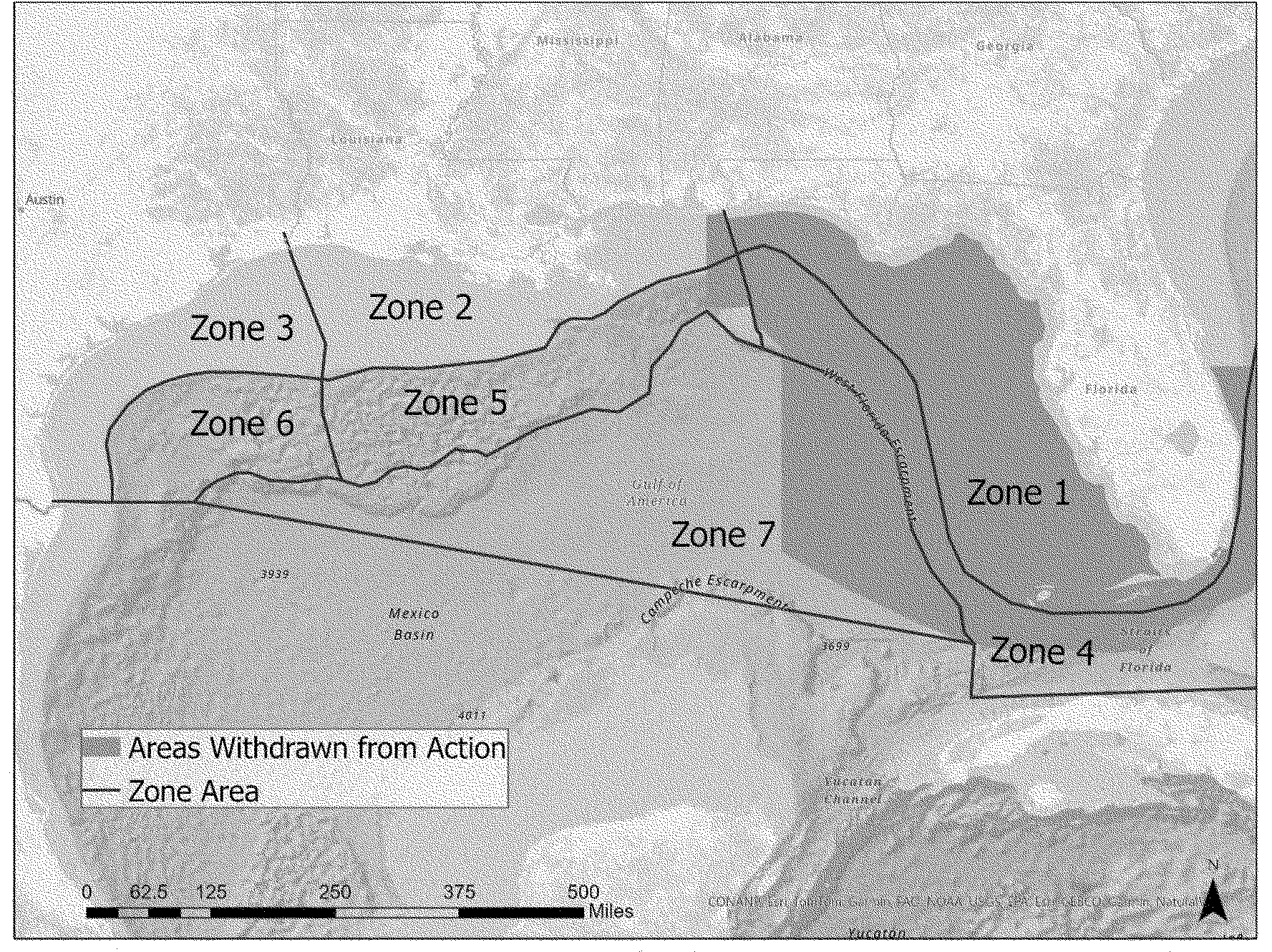
moratorium area) would need to pursue a separate MMPA incidental take authorization (see figure 1).
EnerGeo's 2025 ITR petition suggests that the existing level of effort estimates, by survey type and location, are a reasonable representation of the activities expected to occur under our proposed ITR reimplementation rule (which EnerGeo supports). That petition, available online at:
https://www.fisheries.noaa.gov/action/incidental-take-authorization-oil-and-gas-industry-geophysical-survey-activity-gulf-america,
carries forward the same survey types and similar estimated annual levels of effort by survey type and location as specified over a 10-year period in BOEM's 2016 petition (as adjusted in 2020 by BOEM to account for removal from consideration of the area then under a Congressional leasing moratorium under GOMESA). The most notable difference is EnerGeo's estimate that approximately 40 percent of forecast survey effort may be accomplished using less environmentally impactful alternative sources to airgun arrays (
e.g.,
tuned pulse or dual barbell sources; additional descriptions of these source types may be found in
Federal Register
notices of LOA issuance under the existing ITR,
e.g.,86 FR 37309, July 15, 2021; 87 FR 55790, September 12, 2022; 88 FR 72739, October 23, 2023). NMFS will address these changes to survey effort in a future rulemaking on EnerGeo's petition. For the current rulemaking, we have determined the specified activity that is the subject of this proposed rule is a reasonable projection on which to proceed.
Geophysical surveys are conducted to obtain information on marine seabed and subsurface geology for a variety of reasons, including to obtain data for hydrocarbon and mineral exploration and production; aid in siting of oil and gas structures, facilities, and pipelines; identify possible seafloor or shallow depth geologic hazards; and locate potential archaeological resources and benthic habitats that should be avoided.
Deep penetration seismic surveys using airgun arrays as an acoustic source (sound sources are described in the
Detailed Description of Activities
section) are a primary method of obtaining geophysical data used to characterize subsurface structure. These surveys are designed to illuminate deeper subsurface structures and formations. A deep penetration survey uses an acoustic source suited to provide data on geological formations that may be thousands of meters (m) beneath the seafloor, as compared with a shallow penetration or high resolution geophysical (HRG) survey that may be intended to evaluate shallow subsurface formations or the seafloor itself (
e.g.,
for hazards).
Deep penetration surveys may be two-dimensional (2D) or three-dimensional (3D), and there are a variety of survey methodologies designed to provide the specific data of interest. 2D surveys are designed to acquire data over large areas (thousands of square miles) in order to screen for potential hydrocarbon prospectivity, and provide a cross-sectional image of the structure. In contrast, 3D surveys may use similar acoustic sources but are designed to cover smaller areas with greater resolution (
e.g.,
with closer survey line spacing), providing a volumetric image of underlying geological structures. Repeated 3D surveys are referred to as four-dimensional (4D), or time-lapse, surveys that assess the depletion of a reservoir.
Shallow penetration and high-resolution surveys are designed to highlight seabed and near-surface potential obstructions, archaeology, and geohazards that may have safety implications during rig installation or well and development facility siting. Shallow penetration surveys may use a small airgun array, single airgun, or similar sources, while high-resolution surveys (which are limited to imaging the seafloor itself) may use a variety of sources, such as sub-bottom profilers, single or multibeam echosounders, or side-scan sonars.
Dates and Duration
The specified activities may occur at any time during the 5-year period of validity of the proposed regulations. Actual dates and duration of individual surveys are not known. Although the proposed period of validity is for 5 years, we reiterate the requested reimplementation of regulations would continue only until superseded by a new ITR promulgated on the basis of the separate EnerGeo request.
Specified Geographical Region
Generally speaking, projected survey activity may occur within U.S. waters within the GOA, outside of the former GOMESA moratorium area. The specified geographical region (with modeling zones and depicting the area withdrawn from leasing consideration) is depicted in figure 1.
( printed page 9018)
Figure 1—Specified Geographical Region
Detailed Description of Activities
An airgun is a device used to emit acoustic energy pulses into the seafloor, and generally consists of a steel cylinder that is charged with high-pressure air. There are different types of airguns; differences between types of airguns are generally in the mechanical parts that release the pressurized air, and the bubble and acoustic energy released are effectively the same. Airguns are typically operated at a firing pressure of 2,000 pounds per square inch (psi). Release of the compressed air into the water column generates a signal that reflects (or refracts) off the seafloor and/or subsurface layers having acoustic impedance contrast. Individual airguns are available in different volumetric sizes and, for deep penetration seismic surveys, are towed in arrays (
i.e.,
a certain number of airguns of varying sizes in a certain arrangement) designed according to a given company's method of data acquisition, seismic target, and data processing capabilities.
Airgun arrays are typically configured in subarrays of 6-12 airguns each. The airgun array is typically towed at a speed of approximately 4.5 to 5 knots (kn). The output of an airgun array is directly proportional to airgun firing pressure or to the number of airguns, and is expressed as the cube root of the total volume of the array.
Airguns are considered to be low-frequency acoustic sources, producing sound with energy in a frequency range from less than 10 hertz (Hz) to 2 kHz (though there may be energy at higher frequencies), with most energy radiated at frequencies below 500 Hz. Frequencies of interest to industry are below approximately 100 Hz. The amplitude of the acoustic wave emitted from the source is equal in all directions (
i.e.,
omnidirectional) for a single airgun, but airgun arrays do possess some directionality due to phase delays between guns in different directions. Airgun arrays are typically tuned to maximize functionality for data acquisition purposes, meaning that sound transmitted in horizontal directions and at higher frequencies is minimized to the extent possible.
When fired, a brief (~0.1 second) pulse of sound is emitted by all airguns in an array nearly simultaneously, in order to increase the amplitude of the overall source pressure signal. The combined signal amplitude and directivity is dependent on the number and sizes of individual airguns and their geometric positions within the array. The airguns are silent during the intervening periods, with the array typically fired on a fixed distance (or shot point) interval. The intervals are optimized for water depth and the distance of important geological features below seafloor, but a typical interval in relatively deep water might be approximately every 10-20 seconds (or 25-50 m, depending on vessel speed). The return signal is recorded by a listening device, and later analyzed with computer interpretation and mapping systems used to depict the subsurface. There must be enough time between shots for the sound signals to propagate down to and reflect from the feature of interest, and then to propagate upward to be received on hydrophones or geophones. Reverberation of sound from previous shots must also be given time to dissipate. The receiving hydrophones can be towed behind or in front of the airgun array (may be towed from the source vessel or from a separate receiver vessel), or ocean bottom nodes (OBN) containing geophone receivers can be deployed on the seabed. Receivers may be displaced several kilometers (km) horizontally away from the source, so horizontal propagation time is also considered in setting the interval between shots.
( printed page 9019)
Sound levels for airgun arrays are typically modeled or measured at some distance from the source and a nominal source level then back-calculated. Because these arrays constitute a distributed acoustic source rather than a single point source (
i.e.,
the “source” is actually comprised of multiple sources with some predetermined spatial arrangement), the highest sound levels measurable at any location in the water will be less than the nominal source level. At sufficient distance—in the far field—the array may be perceived as a single point source but individual sources, each with less intensity than that of the whole, may be discerned at closer distances (Caldwell and Dragoset (2000) define the far field as greater than 250 m; though this distance is dependent on the array dimensions). Therefore, back-calculated source levels are not typically considered to be accurate indicators of the true maximum amplitude of the output in the far field, which is what is typically of concern in assessing potential impacts to marine mammals. In addition, the effective source level for sound propagating in near-horizontal directions (
i.e.,
directions likely to impact most marine mammals in the vicinity of an array) is likely to be substantially lower (
e.g.,
15-24 decibels (dB); Caldwell and Dragoset, 2000) than the nominal source level applicable to downward propagation because of the directional nature of the sound from the airgun array. The horizontal propagation of sound is reduced by noise cancellation effects created when sound from neighboring airguns on the same horizontal plane partially cancel each other out.
Alternative sources to conventional airgun arrays are increasingly used in deep penetration surveys. These sources, such as the tuned pulse source (TPS) or dual barbell sources, are expected to present lower potential for impacts to marine mammals but they operate on the same basic principles as traditional airgun sources in that they use compressed air to create a bubble in the water column which then goes through a series of collapses and expansions creating primarily low-frequency sounds. Because of the increasing potential for use of these sources, we describe them briefly here to show that they (and their potential impacts) fall within the scope of this proposed rule. However, the acoustic exposure modeling supporting this rule, and the estimated marine mammal take numbers evaluated herein, assume that airgun sources are used during all projected survey effort.
The difference between the TPS and airgun sources is that the TPS releases a larger volume of air, but at lower pressure. This creates a larger bubble resulting in more of the energy being concentrated in low-frequencies. The release of the air is also “tuned” so that the primary signal has an extended rise time and lower peak pressure level than that of a traditional airgun array source. Field data confirm that the TPS produces more sound at lower frequencies (approximately 2-4 Hz) compared to an airgun source, while producing much less sound (lower decibel levels) at frequencies above 4 Hz, meaning that the source produces significantly reduced energy at frequencies used by marine mammals for hearing and communication. This means that even for species in the low-frequency hearing group (mysticete whales) most affected by seismic survey sounds, the TPS is expected to have less impact than a traditional airgun array in terms of overlap with frequencies the species use. Potential impacts on high- and very high-frequency hearing groups will be reduced even more.
Dual barbell sources consist of one physical element with two large chambers, similarly creating a larger bubble resulting in more of the energy being concentrated in low frequencies. In addition to concentrating energy at lower frequencies, these sources are expected to produce lower overall sound levels than conventional airgun sources. The number of airguns in an array is highly influential on overall sound energy output, because the output increases approximately linearly with the number of airgun elements. In this case, because the same air volume is used to operate two very large guns, rather than tens of smaller guns, the array produces lower sound levels than a conventional array of equivalent total volume.
Survey protocols generally involve a predetermined set of survey, or track, lines. The seismic acquisition vessel(s) (source vessel) will travel down a linear track for some distance until a line of data is acquired, then turn and acquire data on a different track. In some cases, data is acquired as the source vessel(s) turns continuously rather than moving on a linear track (
i.e.,
coil surveys). The spacing between track lines and the length of track lines can vary greatly, depending on the objectives of a survey. Spacing and length of tracks varies by survey.
The general activities described here could occur pre- or post-leasing and/or on- or off-lease. Pre-lease surveys are more likely to involve larger-scale activity designed to explore or evaluate geologic formations. Post-lease activities may also include deep penetration surveys, but would be expected to be smaller in spatial and temporal scale as they are associated with specific leased blocks. Shallow penetration and HRG surveys are more likely to be associated with specific leased blocks and/or facilities, with HRG surveys used along pipeline routes and to search for archaeological resources and/or benthic communities.
2D and 3D Surveys (Deep Penetration Surveys)
—Deep penetration surveys may use an airgun array(s) as the acoustic source and may be 2D or 3D (with repeated 3D surveys termed 4D). Surveys may be designed as either multi-source (
i.e.,
multiple arrays towed by one or more source vessel(s)) or single source.
We described previously the basic differences between 2D and 3D surveys. A typical 2D survey deploys a single array, whereas a 3D vessel may deploy multiple source arrays. Among 3D surveys in particular, there are a variety of survey designs employed to acquire the specific data of interest. Conventional, single-vessel 3D surveys are referred to as narrow azimuth (NAZ) surveys. Survey techniques using multiple source vessels, often referred to as wide-azimuth (WAZ) surveys, help to provide better data quality than that achievable using traditional NAZ surveys, including better illumination, higher signal-to-noise ratios, and higher resolution. This is useful in imaging subsurface areas containing complex geologic structures, particularly those beneath salt bodies with irregular geometries.
In summary, 3D survey design involves a vessel with one or more acoustic sources covering an area of interest with relatively tight spatial configuration. In order to provide richer, more useful data, particularly in areas with more difficult geology, survey designs become more complicated with additional source and/or receiver vessels operating in potentially increasingly complicated choreographies. The time required to complete one pass of a trackline for a single NAZ vessel and the time required for one pass by a multi-vessel entourage conducting a WAZ survey will be essentially the same. Turn times will be somewhat longer during multi-vessel surveys to ensure that all vessels are properly aligned prior to beginning the next trackline. Coil surveys, described previously, reduce the total survey time due to elimination of the trackline-turn methodology. Note that, while coil surveys occur infrequently in the GOA, the coil survey simulation is applicable to a variety of survey types that are
( printed page 9020)
conducted within smaller areas than 2D and 3D survey types.
Borehole Seismic Surveys
—The placement of seismic sensors in a drilled well or borehole is another way data can be acquired. These surveys, typically referred to as vertical seismic profiles (VSP), provide information about geologic structure, lithology, and fluids that is intermediate between that obtained from sea surface surveys and well-log scale information (well logging is the process of recording various physical, chemical, electrical, or other properties of the rock/fluid mixtures penetrated by drilling a borehole). VSP surveying is conducted by placing receivers at many (50-200) depths in a wellbore and recording both direct-arriving and reflection energy from an acoustic source. The acoustic source usually is a single airgun or small airgun array hung from a platform or deployed from a source vessel. The airguns used for VSPs may be the same or similar to those used for 2D and 3D surveys; however, the number of airguns and the total volume of an array used are typically less. Some VSP surveys take less than a day, and most are completed in a few days. Borehole seismic surveys include 2D VSPs, 3D VSPs, and other types of surveys.
Shallow Penetration/HRG Surveys
—These surveys are conducted to provide data informing initial site evaluation, drilling rig emplacement, and platform or pipeline design and emplacement. Identification of geohazards (
e.g.,
gas hydrates, buried channels) is necessary to avoid drilling and facilities emplacement problems, and operators are required to identify and avoid archaeological resources and certain benthic communities. In most cases, conventional 2D and 3D deep penetration surveys do not have the correct resolution to provide the required information. Shallow penetration surveys typically use small airgun arrays, paired or single airguns, or non-airgun impulsive sources such as sparkers or boomers. HRG surveys generally use electromechanical sources, including sources that are not likely to cause incidental take of marine mammals, such as sub bottom profilers, echosounders, and side-scan sonars (Ruppel
et al.,
2022).
Representative Sound Sources
Because the specifics of acoustic sources to be used cannot be known in advance of receiving LOA requests from industry operators, it is necessary to define representative acoustic source parameters, as well as representative survey patterns. The supporting modeling for the 2021 ITR considered two specific airgun array sizes/configurations (4,130 and 8,000 in3
arrays) as well as a single, 90-in3
airgun. For the 2024 rule, modeling of a third representative airgun array size (5,110-in3
) was also specifically considered. In its petition for the 2021 ITR, BOEM determined realistic representative proxy sound sources and survey patterns. We note that EnerGeo's 2025 petition for a new ITR carries forward these assumed proxies regarding survey patterns, as well as the 5,110-in3
array modeled for the 2024 rule, as representative of ongoing industry survey activities in the GOA.
Acoustic exposure modeling for the 8,000-in3
airgun array and 90-in3
single airgun, which provided support for the 2021 rule, was described in detail in “Acoustic Propagation and Marine Mammal Exposure Modeling of Geological and Geophysical Sources in the Gulf of Mexico” and “Addendum to Acoustic Propagation and Marine Mammal Exposure Modeling of Geological and Geophysical Sources in the Gulf of Mexico” (Zeddies
et al.,
2015, 2017a). Additional information, including evaluation of the 4,130-in3
airgun array, was provided in “Gulf of Mexico Acoustic Exposure Model Variable Analysis” (Zeddies
et al.,
2017b).
Representative sources for the modeling include the three different airgun arrays, the single airgun, and an acoustic source package including a sub-bottom profiler in combination with multibeam echosounder and side-scan sonar. Two major survey types were considered: large-area seismic (including 2D, 3D NAZ, 3D WAZ, and coil surveys) and small-area, high-resolution geotechnical (including single airgun surveys and HRG surveys using the aforementioned package of sources). The nominal airgun sources used for analysis of this proposed rule include a small single airgun (90-in3
airgun) and a large airgun array (8,000-in3
). While the 5,110-in3
airgun array is considered most representative of the airgun sources that are likely to be used during deep penetration surveys during the period of effectiveness of this proposed ITR, the 8,000-in3
airgun array results in larger take numbers for most species for which acoustic exposures were modeled, and therefore provide the basis for the analysis herein, thus allowing the flexibility for applicants to use larger sources when survey objectives dictate. The modeling for the alternative 4,130- and 5,110-in3
arrays provides more realistic estimates of take for use in survey-specific LOAs, depending on the actual acoustic sources planned for use (see Letters of Authorization section). We note that while high-resolution geophysical sources were included for consideration in the 2021 final rule to allow for take authorization if necessary, these types of sources would not typically be expected to cause the incidental take of marine mammals (Ruppel
et al.,
2022).
New technologies and/or uses of existing technologies may come into practice during the period of validity of these proposed regulations. As under the 2021 and 2024 final rules, NMFS will evaluate any such developments on a case-specific basis to determine whether expected impacts on marine mammals are consistent with those described or referenced in this document and, therefore, whether any anticipated take incidental to use of those new technologies or practices may appropriately be authorized under the existing regulatory framework. See Letters of Authorization for additional information.
Estimated Levels of Effort
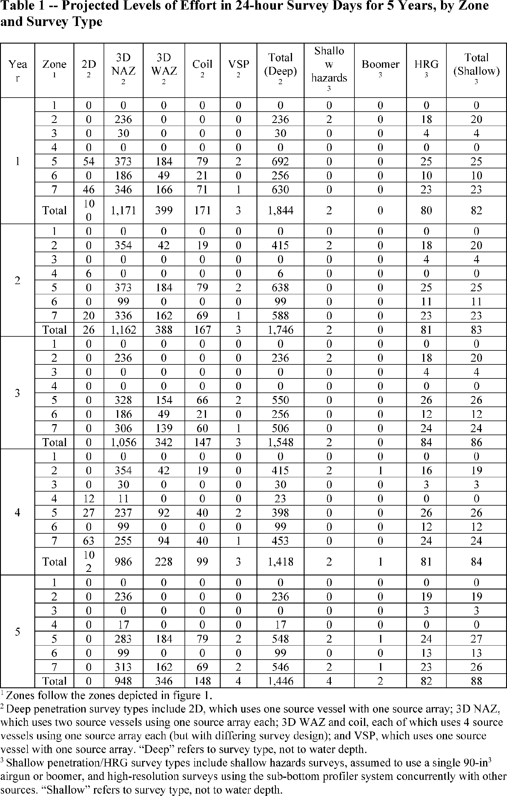
Actual total amounts of effort by survey type and location cannot be known in advance of receiving LOA requests from survey operators. Therefore, BOEM's 2017 PEIS provided projections of survey level of effort for the different survey types for a 10-year period (and BOEM refined those projections following removal of the GOMESA area from the scope of activity in 2020). As noted above, these estimated levels of effort remain representative of expected survey activity on an ongoing basis and, therefore, are carried forward unchanged. Table 1 provides those effort projections for the next 5-year period.
In order to provide some spatial resolution to the projections of survey effort and to provide reasonably similar areas within which acoustic modeling might be conducted, the geographic region was divided into seven zones, largely on the basis of water depth, seabed slope, and defined BOEM planning area boundaries. Shelf regions typically extend from shore to approximately 100-200 m water depths
( printed page 9021)
where bathymetric relief is gradual. The slope starts where the seabed relief is steeper and extends into deeper water. In the GOA water deepens from 100-200 m to 1,500-2,500 m over as little as a 50 km horizontal distance. As the slope ends, water depths become more consistent, though depths can vary from 2,000 to 3,300 m. Three primary bathymetric areas were defined as shelf (0-200 m water depth), slope (200-2,000 m), and deep (>2,000 m).
Available information regarding cetacean density in the GOA shows that, in addition to water depth, animal distribution tends to vary from east to west in the GOA and appears correlated with the width of shelf and slope areas from east to west. The western region is characterized by a relatively narrow shelf and moderate-width slope. The central region has a moderate-width shelf and moderate-width slope, and the eastern region has a wide shelf and a very narrow slope. Therefore, BOEM's western, central, and eastern planning area divisions provide appropriate longitudinal separations for the shelf and slope areas. Due to relative consistency in both physical properties and predicted animal distribution, the deep area was not subdivided. As shown in figure 1, zones 1-3 represent the shelf area (from east to west), zones 4-6 represent the slope area (from east to west), and zone 7 is the deep area. Removal of the GOMESA moratorium area from the scope of activity entirely eliminated zone 1 from consideration, and reduced zone 4 by approximately 98 percent and zone 7 by 33 percent. Smaller portions of zones 2 and 5 were also removed from consideration (figure 1).
( printed page 9022)
( printed page 9023)
Description of Marine Mammals in the Area of the Specified Activities
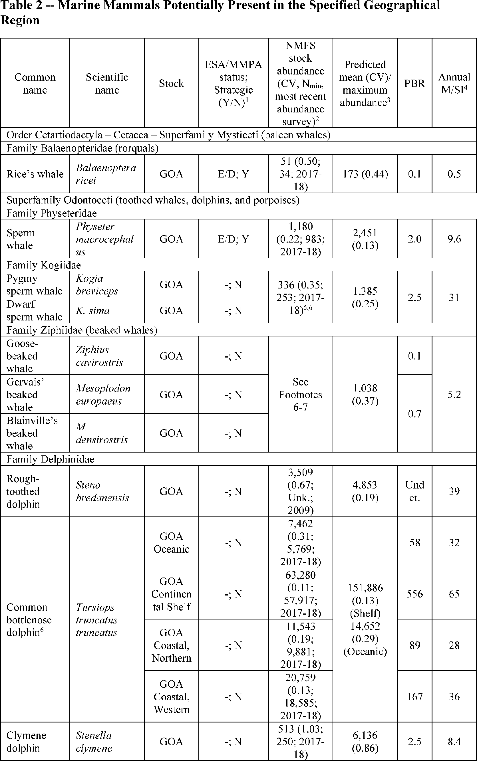
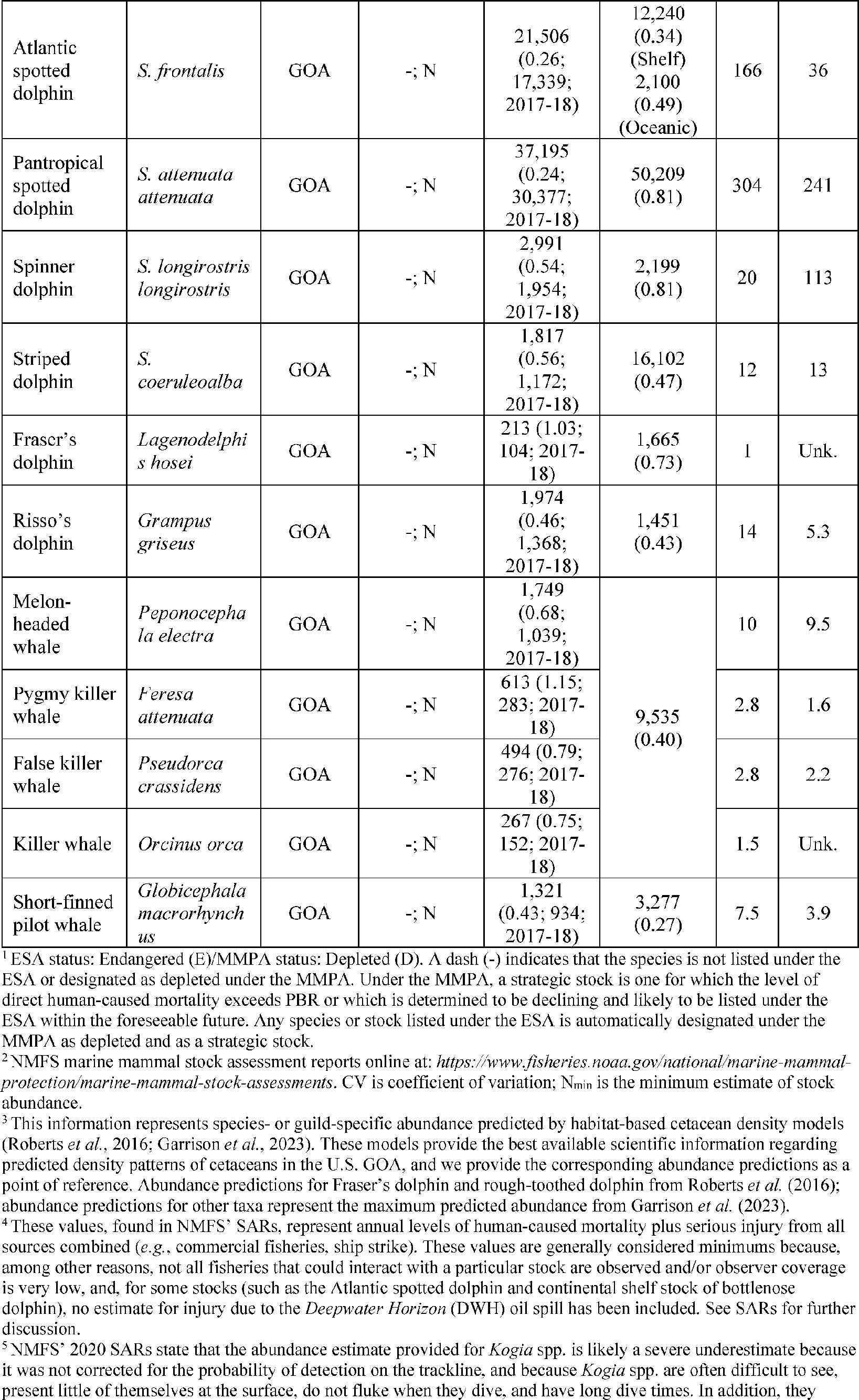
Table 2 lists all species with expected potential for occurrence in the GOA and summarizes information related to the population or stock, including potential biological removal (PBR). PBR, defined by the MMPA as the maximum number of animals, not including natural mortalities, that may be removed from a marine mammal stock while allowing that stock to reach or maintain its optimum sustainable population, is considered in concert with known sources of ongoing anthropogenic mortality (as described in NMFS' stock assessment reports (SAR)). For status of species, we provide information regarding U.S. regulatory status under the MMPA and Endangered Species Act (ESA).
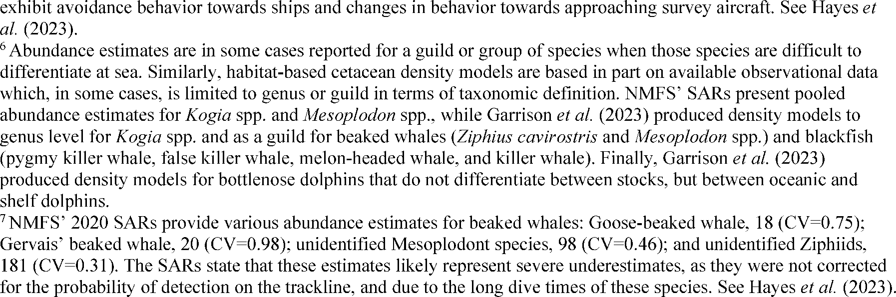
In some cases, species are treated as guilds. In general ecological terms, a guild is a group of species that have similar requirements and play a similar role within a community. However, for purposes of stock assessment or density modeling, certain species may be treated together as a guild because they are difficult to distinguish visually and many observations are ambiguous. For example, NMFS' GOA SARs assess stocks of
Mesoplodon
spp. and
Kogia
spp. as guilds. Following this approach, we consider beaked whales and
Kogia
spp. as guilds. In this rule, reference to “beaked whales” includes the goose-beaked whale [4]
and Blainville's and Gervais' beaked whales, and reference to “
Kogia
spp.” includes both the dwarf and pygmy sperm whale.
The use of guilds herein follows the best available density information (
i.e.,
Garrison
et al.,
2023). The density models treat beaked whales and
Kogia
spp. as guilds and consolidate four species into an undifferentiated blackfish guild. These species include the melon-headed whale, false killer whale, pygmy killer whale, and killer whale. The model authors determined that, for this group of species, there were insufficient sightings of any individual species to generate a species-specific model (Garrison
et al.,
2023). Therefore, reference to blackfish hereafter includes the melon-headed whale, false killer whale, pygmy killer whale, and killer whale.[5]
Twenty-one species (with 24 managed stocks) have the potential to co-occur with the prospective survey activities. All managed stocks in this region are assessed in NMFS' U.S. Atlantic SARs. All values presented in table 2 are the most recent available. For more information, please see information presented in the SARs (available online at:
https://www.fisheries.noaa.gov/national/marine-mammal-protection/marine-mammal-stock-assessment-reports).
( printed page 9024)
( printed page 9025)
( printed page 9026)
In table 2 above, we report two sets of abundance estimates: those from NMFS' SARs and those predicted by habitat-based cetacean density models. Please see footnote 3 of table 2 for more detail. NMFS' SAR estimates are typically generated from the most recent shipboard and/or aerial surveys conducted. GOA oceanography is dynamic, and the spatial scale of the GOA is small relative to the ability of most cetacean species to travel. U.S. waters only comprise about 40 percent of the entire GOA, and 65 percent of GOA oceanic waters are south of the U.S. EEZ. Studies based on abundance and distribution surveys restricted to U.S. waters are unable to detect temporal shifts in distribution beyond U.S. waters that might account for any changes in abundance within U.S. waters. NMFS' SAR estimates also in some cases do not incorporate correction for detection bias. Therefore, for cryptic or long-diving species (
e.g.,
beaked whales,
Kogia
spp., sperm whales), they should generally be considered underestimates (see footnotes 5 and 7 of table 2).
The model-based abundance estimates represent the output of predictive models derived from multi-year observations and associated environmental parameters and which incorporate corrections for detection bias (the same models and data from which the density estimates are derived). Incorporating more data over multiple years of observation can yield different results in either direction, as the result is not as readily influenced by fine-scale shifts in species habitat preferences or by the absence of a species in the study area during a given year. NMFS' SAR abundance estimates show substantial year-to-year variability in some cases. Incorporation of correction for detection bias should systematically result in greater abundance predictions. For these reasons, the model-based estimates are generally more realistic and, for the purposes of assessing estimated exposures relative to abundance—used in this case to understand the scale of the predicted takes compared to the population—NMFS generally believes that the model-based abundance predictions are the best available information and most appropriate because they were used to generate the exposure estimates and therefore provide the most relevant comparison.
As part of our evaluation of the environmental baseline, which is considered as part of the negligible impact analysis, we consider any known areas of importance as marine mammal habitat. We also consider other relevant information, such as unusual mortality events (UME) and the 2010
Deepwater Horizon
oil spill.
Habitat
—Important habitat areas may include areas of known importance for reproduction, feeding, or migration, or areas where small and resident populations are known to occur. They may have independent regulatory status such as designated critical habitat for ESA-listed species (as defined by section 3 of the ESA) or be identified through other means (
e.g.,
recognized Biologically Important Areas (BIA)).
No critical habitat has yet been designated for the Rice's whale, though a proposed rule to do so was published (88 FR 47453, July 24, 2023). The proposal references the same supporting information discussed herein in suggesting that GOA continental slope waters between 100 and 400 m water depth be designated as critical habitat. In addition, a BIA has been recognized since 2015 (LaBrecque
et al.,
2015).
Our knowledge of Rice's whale distribution is based on a combination of historic and contemporary sightings, passive acoustic detections, and spatial modeling. The Rice's whale was historically typically observed only within a narrowly circumscribed area within the eastern GOA, leading to the area being described as a year-round BIA by LaBrecque
et al.
(2015). In sightings data available to support that description, whales were observed only between approximately the 100- and 300-m isobaths in the eastern GOA from the head of the De Soto Canyon (south of Pensacola, Florida) to northwest of Tampa Bay, Florida (Maze-Foley and Mullin, 2006; Waring
et al.,
2016; Rosel and Wilcox, 2014; Rosel
et al.,
2016). NOAA's ESA status review of the species (formerly the GOM Bryde's whale) (Rosel
et al.,
2016) expanded the 2015 BIA description by stating that, due to the depth of some sightings, the area is appropriately defined to the 400-m isobath and westward to Mobile Bay, Alabama, in order to provide some buffer around the deeper sightings and to include all sightings in the northeastern GOA. This area is now considered to mark a core habitat area for the species, versus its entire range within the GOA (as described in the 2023 proposed critical habitat designation). The core habitat area contains the highest known densities of Rice's whale and has defined the movements of previously tagged Rice's whales.
More recent scientific data, including visual and acoustic detections, now indicate that Rice's whales occupy waters along the continental shelf and slope and adjacent waters throughout the U.S. GOA, and in particular, waters between 100 and 400 m deep. The widest swath of habitat occurs in the species' aforementioned core habitat area in the northeastern GOA, south and west of Alabama and Florida. However, a contiguous strip of habitat also extends south of the core habitat area toward the Florida Keys, and westward along the continental shelf and slope offshore of Mississippi, Louisiana, and Texas (Garrison
et al.,
2023). Passive acoustic monitoring (PAM) recordings have been especially valuable for confirming the species' year-round presence in the central and western GOA (Soldevilla
et al.,
2022, 2024), helping to offset the limited visual
( printed page 9027)
survey effort in those locations. The shallowest and deepest waters where Rice's whales have been confirmed visually to date are 117 m and 408 m, respectively, but Rice's whales may use waters that are deeper or shallower than those values at times, and unconfirmed sightings from protected species observers (PSOs) have occurred at a wider range of locations and depths (Barkaszi and Kelley, 2018, 2024).
Current understanding regarding Rice's whale occurrence in the central and western GOA is largely based on passive acoustic detections (Soldevilla
et al.,
2022; 2024). As background, a NOAA survey reported observation of a Rice's whale in the western GOA in 2017 (Garrison
et al.,
2020). Genetic analysis of a skin biopsy that was collected from the whale confirmed it to be a Rice's whale. There had not previously been a genetically verified sighting of a Rice's whale in the western GOA, and given the importance of this observation, additional survey effort was conducted in an attempt to increase effort in the area. However, no additional sightings were recorded (note that there were two sightings of unidentified large baleen whales in 1992 in the western GOA, recorded as
Balaenoptera
sp. or Bryde's/sei whale (Rosel
et al.,
2021)). Subsequently, during 2023 survey effort in the western GOA, a sighting of what has been described as a group of two probable Rice's whales was recorded (
https://www.fisheries.noaa.gov/science-blog/successful-final-leg-gulf-america-marine-mammal-and-seabird-vessel-survey). In addition, there are occasional sightings by PSOs of baleen whales in the GOA that may be Rice's whales. Rosel
et al.
(2021) reviewed 13 whale sightings reported by PSOs in the GOA from 2010-2014 that were recorded as baleen whales. No sightings were close enough for the PSOs to see the diagnostic three lateral ridges on the whales' rostrums required to confirm them as Rice's whales. Rosel
et al.
ruled out five of the sightings as more likely being sperm whales based on water depth and descriptions of the whales' behavior. The remaining eight sightings may have been Rice's whales based on one or more lines of evidence (
i.e.,
photographs, behavioral description, and/or water depth consistent with Rice's whales). Of these sightings, three occurred in the northeastern GOA core habitat area, while the remaining five occurred along the GOA shelf break south of Louisiana.
The acoustic detections provide evidence of year-round Rice's whale presence outside of the northeastern GOA core habitat area. Soldevilla
et al.
(2022) deployed autonomous passive acoustic recorders at 5 sites along the GOA shelf break in predicted Rice's whale habitat (Roberts
et al.,
2016) for 1 year (2016-2017) to (1) determine if Rice's whales occur in waters beyond the northeastern GOA and, if so, (2) evaluate their seasonal occurrence and site fidelity at the five sites. Over the course of the 1-year study, sporadic, year-round recordings of calls assessed as belonging to Rice's whales were made south of Louisiana within approximately the same depth range (200-400 m), indicating that some Rice's whales occurred regularly in waters beyond the northeastern GOA core habitat area during the study period. Based on the detection range of the sonobuoys and acoustic monitors used in the study, actual occurrence could be in water depths up to 500 m (M. Soldevilla, pers. comm.), though the deepest confirmed Rice's whale sighting is at 408 m water depth. Data were successfully collected at four of the five sites; of those four sites, Rice's whale calls were detected at three. Detection of calls ranged from 1 to 16 percent of total days at the three sites. Calls were present in all seasons at two sites, with no obvious seasonality. It remains unknown whether animals are moving between the northwestern and the northeastern GOA or whether these represent different groups of animals (Soldevilla
et al.,
2022).
A subsequent follow-up study (Soldevilla
et al.,
2024) similarly involved deployment of autonomous passive acoustic recorders for approximately 1 year (2019-2020) at two shelf break sites, including one central GOA site included in the previous study and one new site further west, offshore Corpus Christi, Texas (recorders were also deployed at a site in Mexican waters for almost 2 years (2020-2022)). The study objectives were to (1) determine if Rice's whales occur in Mexican waters and to (2) evaluate how frequently they occur at all three sites. Rice's whale calls were detected on 33 and 25 percent of days at the central and western GOA sites, respectively, with calls recorded throughout the year, though no distinct seasonality was detected. These findings reflect an increase in the frequency and number of detections at the central GOA site compared with the 2016-2017 study. The authors note that these findings highlight persistence of Rice's whale detections at this site over multiple years, as well as variability among years (Soldevilla
et al.,
2024). Rice's whale calls were also detected at the site in Mexican waters (see Soldevilla
et al.
(2024) for additional discussion). The authors also describe differences in Rice's whale call types recorded in the eastern GOA compared with those recorded in the western GOA, suggesting that whales may indeed have a broader distribution than the northeastern GOA (Soldevilla
et al.,
2024).
The rate of call detections throughout the year is considerably higher in the eastern GOA than at the central/western GOA site where calls were most commonly detected, with at least 8.3 calls/hour among four eastern GOA sites within the core habitat area over 110 deployment days (Rice
et al.,
2014) compared to 0.27 calls/hour over the 299-day deployment at the central/western GOA site where calls were detected most frequently in the 2016-2017 study. Approximately 2,000 total calls were detected at the central/western GOA site over 10 months in 2016-2017, compared to more than 66,000 total detections at the eastern GOA deployment site over 11 months (
i.e.,
approximately 30 times more calls were detected at the eastern GOA site; Soldevilla
et al.,
2022). Although ambient noise conditions were higher at the central/western GOA site, thus influencing maximum detection range, accounting for this difference in conditions would be expected to result in only 4-8 times as many call detections if all other factors (including presence and number of whales) were consistent (versus 30 times as many detections). Overall, Soldevilla
et al.
(2022) assessed that there seem to be fewer whales or more sparsely spaced whales in the central/western GOA compared to the eastern GOA, with calls present on fewer days, lower call detection rates, and far fewer call detections in the central/western GOA.
The passive acoustic data discussed above provide evidence that waters 100-400 m deep in the central and western GOA are Rice's whale habitat and are being used by Rice's whales in all seasons. This could imply that the population size is larger than previously estimated, or it could indicate that some individual Rice's whales have a broader distribution in the GOA than previously understood (Soldevilla
et al.,
2024). Either way, the acoustic findings, combined with the low numbers of visual sightings in the central and western GOA, suggest that density and abundance of Rice's whales in the central and western GOA are less than in the core habitat in the northeastern GOA. Therefore, while we expect that some individual Rice's whales occur outside the core habitat area and/or that whales from the northeastern GOA core
( printed page 9028)
habitat area occasionally travel outside the area, the currently available data are not sufficient to make inferences about Rice's whale density and abundance in the central and western GOA. More research is needed to answer key questions about Rice's whale density, abundance, habitat use, demography, and stock structure in the central and western GOA.
While these acoustic data and few confirmed sightings support the presence of Rice's whales in western and central GOA waters (within the 100-400 m water depth), the information is consistent with the predictions of Rice's whale density modeling, on which basis NMFS has anticipated and evaluated the potential for and effects of takes of Rice's whale in western and central GOA waters. Little is known about the number of whales that may be present, the nature of these individuals' use of the habitat, or the timing, duration, or frequency of occurrence for individual whales. Conversely, the importance of northeastern GOA waters to Rice's whale recovery is clear (Rosel
et al.,
2016). A comparison of acoustic and sightings data from the central/western and eastern GOA, even acknowledging the limitations of those data, suggests that occurrence of whales in the northeastern GOA core habitat is significantly greater and that the area provides the habitat of greatest importance to the species.
Finally, we acknowledge the “core distribution area” described in the 2024 final rule. Delineation of the core distribution area was an effort by NMFS SEFSC (Rosel and Garrison, 2022) to more systematically delimit the previously described core habitat area, including through the addition of buffers around confirmed sightings and location data from tagged whales to account for potential uncertainty in whale locations and possible movements from those locations. However, the result of this precautionary approach was that areas outside of Rice's whale habitat (NMFS, 2023) were included in the core distribution area. We discussed the relevance of this area in relation to our understanding of Rice's whale habitat in detail in the 2024 final rule. In summary, while the actual Rice's whale core habitat area (
i.e.,
the aforementioned area containing the majority of Rice's whale sightings, containing the movements of previously tagged whales, and where the volume and rate of acoustic detections is highest) is entirely outside the geographic scope of the rule; 5 percent of the core distribution area overlaps the scope of this rule. Within that small portion of the core distribution area, 76 percent covers waters shallower than 100 m (36 percent) or deeper than 400 m (40 percent),
i.e.,
three-quarters of the area covers waters considered outside of most suitable Rice's whale habitat. Therefore, we have determined that the “core distribution area” described by Rosel and Garrison (2022) has no relevance within the geographic scope of this rule beyond consideration of Rice's whale habitat (assumed to be within waters 100-400 m in depth) throughout the geographic scope. We do not further discuss the core distribution area.
Deepwater Horizon Oil Spill
—In 2010, the
Macondo
well blowout and explosion aboard the
Deepwater Horizon
drilling rig (also known as the
Deepwater Horizon
explosion, oil spill, and response; hereafter referred to as the DWH oil spill) caused oil, natural gas, and other substances to flow into the GOA for 87 days before the well was sealed. Total oil discharge was estimated at 3.19 million barrels (134 million gallons), resulting in the largest marine oil spill in history (DWH NRDA Trustees, 2016). In addition, the response effort involved extensive application of dispersants at the seafloor and at the surface, and controlled burning of oil at the surface was also used extensively as a response technique. The oil, dispersant, and burn residue compounds continue to present ecological challenges in the region. NMFS discussed the impacts of the DWH oil spill on marine mammals in detail in its 2018 notice of proposed rulemaking (83 FR 29212; June 22, 2018), and we refer the reader to that document for additional detail. The 2018 proposed rule provided detailed discussion of the DWH oil spill. There is no new information regarding the DWH oil spill. Estimates of annual mortality for many stocks over the period 2014-2018 include mortality attributed to the effects of the DWH oil spill (see table 2) (Hayes
et al.,
2023), and these mortality estimates are considered as part of the environmental baseline.
An Unusual Mortality Event (UME) affecting multiple cetacean species in the northern GOA occurred from 2010 to 2014. Additional information on the UME is available online at:
https://www.fisheries.noaa.gov/national/marine-life-distress/2010-2014-cetacean-unusual-mortality-event-northern-gulf-mexico.
In summary, the event included all cetaceans stranded during this time in Alabama, Mississippi, and Louisiana and all cetaceans other than bottlenose dolphins stranded in the Florida Panhandle (Franklin County through Escambia County), with a total of 1,141 cetaceans stranded or reported dead offshore. For reference, the same area experienced a normal average of 75 strandings per year from 2002 to 2009 (Litz
et al.,
2014). The majority of stranded animals were bottlenose dolphins, though at least 10 additional species were reported as well. Since not all cetaceans that die wash ashore where they may be found, the number reported stranded is likely a fraction of the total number of cetaceans that died during the UME. The UME investigation and the
Deepwater Horizon
Natural Resource Damage Assessment determined that the DWH oil spill was the most likely explanation of the persistent, elevated stranding numbers in the northern GOA after the 2010 spill.
In summary, coastal and oceanic marine mammals were injured by exposure to oil from the DWH spill. Nearly all of the stocks that overlap with the oil spill footprint have demonstrable, quantifiable injuries, and the remaining stocks (for which there is no quantifiable injury) were also likely injured, though there is not currently enough information to make a determination. Injuries included elevated mortality rates, reduced reproduction, and disease. Due to these effects, affected populations may require decades to recover absent successful efforts at restoration (
e.g.,
DWH NRDA Trustees, 2017). The ability of the stocks to recover and the length of time required for that recovery are tied to the carrying capacity of the habitat, and to the degree of other population pressures. NMFS treats the effects of the DWH oil spill as part of the baseline in considering the likely resilience of these populations to the effects of the activities considered in this proposed rule.
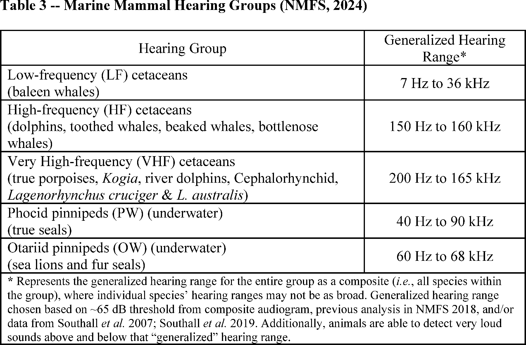
Marine Mammal Hearing
Hearing is the most important sensory modality for marine mammals underwater, and exposure to anthropogenic sound can have deleterious effects. To appropriately assess the potential effects of exposure to sound, it is necessary to understand the frequency ranges marine mammals are able to hear. Not all marine mammal species have equal hearing capabilities (
e.g.,
Richardson
et al.,
1995; Wartzok and Ketten, 1999; Au and Hastings, 2008). To reflect this, Southall
et al.
(2007, 2019) recommended that marine mammals be divided into hearing groups based on directly measured (behavioral or auditory evoked potential techniques) or estimated hearing ranges
( printed page 9029)
(behavioral response data, anatomical modeling,
etc.). Generalized hearing ranges were chosen based on the ~65 decibel (dB) threshold from composite audiograms, previous analyses in NMFS (2018), and/or data from Southall
et al.
(2007) and Southall
et al.
(2019).
For more detail concerning these groups and associated frequency ranges, please see NMFS (2024) for a review of available information.
Potential Effects of the Specified Activities on Marine Mammals and Their Habitat
This section provides a discussion of the ways in which components of the specified activity may impact marine mammals and their habitat. The Estimated Take section later in this document includes a quantitative analysis of the number of individuals that are expected to be taken by this activity. The Negligible Impact Analysis and Determination section considers the content of this section, the Estimated Take section, and the Proposed Mitigation section, to draw conclusions regarding the likely impacts of these activities on the reproductive success or survivorship of individuals and whether those impacts are reasonably expected to, or reasonably likely to, adversely affect the species or stock through effects on annual rates of recruitment or survival.
Description of Active Acoustic Sound Sources
This section contains a brief technical background on sound, the characteristics of certain sound types, and on metrics used in this proposal inasmuch as the information is relevant to the specified activity and to a discussion of the potential effects of the specified activity on marine mammals found later in this document.
Sound travels in waves, the basic components of which are frequency, wavelength, velocity, and amplitude. Frequency is the number of pressure waves that pass by a reference point per unit of time and is measured in Hz or cycles per second. Wavelength is the distance between two peaks or corresponding points of a sound wave (length of one cycle). Higher frequency sounds have shorter wavelengths than lower frequency sounds, and typically attenuate (decrease) more rapidly, except in certain cases in shallower water. Amplitude is the height of the sound pressure wave or the “loudness” of a sound and is typically described using the relative unit of the dB. A sound pressure level (SPL) in dB is described as the ratio between a measured pressure and a reference pressure (for underwater sound, this is 1 micropascal (μPa)) and is a logarithmic unit that accounts for large variations in amplitude; therefore, a relatively small change in dB corresponds to large changes in sound pressure. The source level (SL) represents the SPL referenced at a distance of 1 m from the source (referenced to 1 μPa) while the received level is the SPL at the listener's position (referenced to 1 μPa).
Root mean square (RMS) is the quadratic mean sound pressure over the duration of an impulse. RMS is calculated by squaring all of the sound amplitudes, averaging the squares, and then taking the square root of the average (Urick, 1983). RMS accounts for both positive and negative values; squaring the pressures makes all values positive so that they may be accounted for in the summation of pressure levels (Hastings and Popper, 2005). This measurement is often used in the context of discussing behavioral effects, in part because behavioral effects, which often result from auditory cues, may be better expressed through averaged units than by peak pressures.
Sound exposure level (SEL; represented as dB re 1 μPa2
-s) represents the total energy contained within a pulse and considers both intensity and
( printed page 9030)
duration of exposure. Peak sound pressure (also referred to as zero-to-peak sound pressure or 0-p) is the maximum instantaneous sound pressure measurable in the water at a specified distance from the source and is represented in the same units as the RMS sound pressure. Another common metric is peak-to-peak sound pressure (pk-pk), which is the algebraic difference between the peak positive and peak negative sound pressures. Peak-to-peak pressure is typically approximately 6 dB higher than peak pressure (Southall
et al.,
2007).
When underwater objects vibrate or activity occurs, sound-pressure waves are created. These waves alternately compress and decompress the water as the sound wave travels. Underwater sound waves radiate in a manner similar to ripples on the surface of a pond and may be either directed in a beam or beams or may radiate in all directions (omnidirectional sources), as is the case for pulses produced by the airgun array considered here. The compressions and decompressions associated with sound waves are detected as changes in pressure by aquatic life and man-made sound receptors such as hydrophones.
Even in the absence of sound from the specified activity, the underwater environment is typically loud due to ambient sound. Ambient sound is defined as environmental background sound levels lacking a single source or point (Richardson
et al.,
1995), and the sound level of a region is defined by the total acoustical energy being generated by known and unknown sources. These sources may include physical (
e.g.,
wind and waves, earthquakes, ice, atmospheric sound), biological (
e.g.,
sounds produced by marine mammals, fish, and invertebrates), and anthropogenic (
e.g.,
vessels, dredging, construction) sound. A number of sources contribute to ambient sound, including the following (Richardson
et al.,
1995):
Wind and waves
—The complex interactions between wind and water surface, including processes such as breaking waves and wave-induced bubble oscillations and cavitation, are a main source of naturally occurring ambient sound for frequencies between 200 Hz and 50 kHz (Mitson, 1995). In general, ambient sound levels tend to increase with increasing wind speed and wave height. Surf sound becomes important near shore, with measurements collected at a distance of 8.5 km from shore showing an increase of 10 dB in the 100 to 700 Hz band during heavy surf conditions;
Precipitation
—Sound from rain and hail impacting the water surface can become an important component of total sound at frequencies above 500 Hz, and possibly down to 100 Hz during quiet times;
Biological
—Marine mammals can contribute significantly to ambient sound levels, as can some fish and snapping shrimp. The frequency band for biological contributions is from approximately 12 Hz to over 100 kHz; and
Anthropogenic
—Sources of anthropogenic sound related to human activity include transportation (surface vessels), dredging and construction, oil and gas drilling and production, seismic surveys, sonar, explosions, and ocean acoustic studies. Vessel noise typically dominates the total ambient sound for frequencies between 20 and 300 Hz. In general, the frequencies of anthropogenic sounds are below 1 kHz and, if higher frequency sound levels are created, they attenuate rapidly. Sound from identifiable anthropogenic sources other than the activity of interest (
e.g.,
a passing vessel) is sometimes termed background sound, as opposed to ambient sound.
The sum of the various natural and anthropogenic sound sources at any given location and time—which comprise “ambient” or “background” sound—depends not only on the source levels (as determined by current weather conditions and levels of biological and human activity) but also on the ability of sound to propagate through the environment. In turn, sound propagation is dependent on the spatially and temporally varying properties of the water column and sea floor, and is frequency-dependent. As a result of this dependence on a large number of varying factors, ambient sound levels can be expected to vary widely over both coarse and fine spatial and temporal scales. Sound levels at a given frequency and location can vary by 10-20 dB from day to day (Richardson
et al.,
1995). The result is that, depending on the source type and its intensity, sound from a given activity may be a negligible addition to the local environment or could form a distinctive signal that may affect marine mammals. Details of source types are described in the following text.
Sounds are often considered to fall into one of two general types: Pulsed and non-pulsed. The distinction between these two sound types is important because they have differing potential to cause physical effects, particularly with regard to hearing (
e.g.,
NMFS, 2018; Ward, 1997 in Southall
et al.,
2007). Please see Southall
et al.
(2007) for an in-depth discussion of these concepts.
Pulsed sound sources (
e.g.,
airguns, explosions, gunshots, sonic booms, impact pile driving) produce signals that are brief (typically considered to be less than 1 second), broadband, atonal transients (American National Standards Institute (ANSI), 1986, 2005; Harris, 1998; National Institute for Occupational Health and Safety (NIOSH), 1998; International Organization for Standardization, 2003) and occur either as isolated events or repeated in some succession. Pulsed sounds are all characterized by a relatively rapid rise from ambient pressure to a maximal pressure value followed by a rapid decay period that may include a period of diminishing, oscillating maximal and minimal pressures, and generally have an increased capacity to induce physical injury as compared with sounds that lack these features.
Non-pulsed sounds can be tonal, narrowband, or broadband, brief or prolonged, and may be either continuous or non-continuous (ANSI, 1995; NIOSH, 1998). Some of these non-pulsed sounds can be transient signals of short duration but without the essential properties of pulses (
e.g.,
rapid rise time). Examples of non-pulsed sounds include those produced by vessels, aircraft, machinery operations such as drilling or dredging, vibratory pile driving, and active sonar systems (such as those used by the U.S. Navy). The duration of such sounds, as received at a distance, can be greatly extended in a highly reverberant environment.
Airgun arrays produce pulsed signals with energy in a frequency range from about 10-2,000 Hz, with most energy radiated at frequencies below 200 Hz. The amplitude of the acoustic wave emitted from the source is equal in all directions (
i.e.,
omnidirectional), but airgun arrays do possess some directionality due to different phase delays between guns in different directions. Airgun arrays are typically tuned to maximize functionality for data acquisition purposes, meaning that sound transmitted in horizontal directions and at higher frequencies is minimized to the extent possible.
Acoustic Effects
Here, we discuss the effects of active acoustic sources on marine mammals.
Potential Effects of Underwater Sound[6]
—Anthropogenic sounds cover a broad range of frequencies and sound
( printed page 9031)
levels and can have a range of highly variable impacts on marine life, from none or minor to potentially severe responses, depending on received levels, duration of exposure, behavioral context, and various other factors. The potential effects of underwater sound from active acoustic sources can potentially result in one or more of the following: Temporary or permanent hearing impairment; non-auditory physical or physiological effects; behavioral disturbance; stress; and masking (Richardson
et al.,
1995; Gordon
et al.,
2004; Nowacek
et al.,
2007; Southall
et al.,
2007; Götz
et al.,
2009). The degree of effect is intrinsically related to the signal characteristics, received level, distance from the source, and duration of the sound exposure. In general, sudden, high level sounds can cause hearing loss, as can longer exposures to lower level sounds. Temporary or permanent loss of hearing, if it occurs at all, will occur almost exclusively in cases where a noise is within an animal's hearing frequency range. We first describe specific manifestations of acoustic effects before providing discussion specific to the use of airgun arrays.
Richardson
et al.
(1995) described zones of increasing intensity of effect that might be expected to occur, in relation to distance from a source and assuming that the signal is within an animal's hearing range. First is the area within which the acoustic signal would be audible (potentially perceived) to the animal, but not strong enough to elicit any overt behavioral or physiological response. The next zone corresponds with the area where the signal is audible to the animal and of sufficient intensity to elicit behavioral or physiological response. Third is a zone within which, for signals of high intensity, the received level is sufficient to potentially cause discomfort or tissue damage to auditory or other systems. Overlaying these zones to a certain extent is the area within which masking (
i.e.,
when a sound interferes with or masks the ability of an animal to detect a signal of interest that is above the absolute hearing threshold) may occur; the masking zone may be highly variable in size.
We describe the more severe effects of certain non-auditory physical or physiological effects only briefly as we do not expect that use of airgun arrays are reasonably likely to result in such effects (see below for further discussion). Potential effects from impulsive sound sources can range in severity from effects such as behavioral disturbance or tactile perception to physical discomfort, slight injury of the internal organs and the auditory system, or mortality (Yelverton
et al.,
1973). Non-auditory physiological effects or injuries that theoretically might occur in marine mammals exposed to high level underwater sound or as a secondary effect of extreme behavioral reactions (
e.g.,
change in dive profile as a result of an avoidance reaction) caused by exposure to sound include neurological effects, bubble formation, resonance effects, and other types of organ or tissue damage (Cox
et al.,
2006; Southall
et al.,
2007; Zimmer and Tyack, 2007; Tal
et al.,
2015). The survey activities considered here do not involve the use of devices such as explosives or mid-frequency tactical sonar that are associated with these types of effects.
Marine mammals, like all mammals, develop increased hearing thresholds over time due to age-related degeneration of auditory pathways and sensory cells of the inner ear. This natural, age-related hearing loss is contrasted by noise-induced hearing loss (Møller, 2012). Marine mammals exposed to high-intensity sound or to lower-intensity sound for prolonged periods can experience a noise-induced hearing threshold shift (TS), which NMFS defines as a change, usually an increase, in the threshold of audibility at a specified frequency or portion of an individual's hearing range above a previously established reference level as a result of noise exposure (NMFS, 2018, 2024). The amount of TS is customarily expressed in dB. Noise-induced hearing TS can be temporary (TTS) or permanent (PTS), and higher-level sound exposures are more likely to cause PTS or other auditory injury. As described in NMFS (2018, 2024) there are numerous factors to consider when examining the consequence of TS, including, but not limited to, the signal temporal pattern (
e.g.,
impulsive or non-impulsive), likelihood an individual would be exposed for a long enough duration or to a high enough level to induce a TS, the magnitude of the TS, time to recovery (seconds to minutes or hours to days), the frequency range of the exposure (
i.e.,
spectral content), the hearing frequency range of the exposed species relative to the signal's frequency spectrum (
i.e.,
how an animal uses sound within the frequency band of the signal;
e.g.,
Kastelein
et al.,
2014), and the overlap between the animal and the source (
e.g.,
spatial, temporal, and spectral).
Auditory Injury (AUD INJ)
NMFS (2024) defines AUD INJ as damage to the inner ear that can result in destruction of tissue, such as the loss of cochlear neuron synapses or auditory neuropathy (Houser 2021; Finneran 2024). AUD INJ may or may not result in a PTS. PTS is subsequently defined as a permanent, irreversible increase in the threshold of audibility at a specified frequency or portion of an individual's hearing range above a previously established reference level (NMFS, 2024). PTS does not generally affect more than a limited frequency range, and an animal that has incurred PTS has some level of hearing loss at the relevant frequencies; typically, animals with PTS or other AUD INJ are not functionally deaf (Au and Hastings, 2008; Finneran, 2016). For marine mammals, AUD INJ is considered to be possible when sound exposures are sufficient to produce 40 dB of TTS measured after exposure (Southall
et al.
2007, 1019). AUD INJ levels for marine mammals are estimates; with the exception of a single study unintentionally inducing PTS in a harbor seal (
Phoca vitulina) (Kastak
et al.,
2008; Reichmuth
et al.
2019), there are no empirical data measuring AUD INJ in marine mammals largely due to the fact that, for various ethical reasons, experiments involving anthropogenic noise exposure at levels inducing AUD INJ are not typically pursued or authorized (NMFS, 2024).
Temporary Threshold Shift (TTS)
TTS is the mildest form of hearing impairment that can occur during exposure to sound. TTS is a temporary, reversible increase in the threshold of audibility at a specified frequency or portion of an individual's hearing range above a previously established reference level (NMFS, 2024) that represents primarily tissue fatigue (Henderson
et al.,
2008), and is not considered an AUD INJ. Based on data from marine mammal TTS measurements (see Southall
et al.,
2007, 2019), a TTS of 6 dB is considered the minimum threshold shift clearly larger than any day-to-day or session-to-session variation in a subject's normal hearing ability (Finneran
et al.,
2000, 2002; Schlundt
et al.,
2000). While experiencing TTS, the hearing threshold rises, and a sound must be at a higher level in order to be heard.
In terrestrial and marine mammals, TTS can last from minutes or hours to days (
i.e.,
there is recovery back to baseline/pre-exposure levels), can occur within a specific frequency range (
i.e.,
an animal might only have a temporary loss of hearing sensitivity within a limited frequency band of its auditory range), and can be of varying amounts (
e.g.,
an animal's hearing sensitivity might be reduced by only 6 dB or reduced by 30 dB). In many cases, hearing sensitivity recovers rapidly after exposure to the sound ends. While there
( printed page 9032)
are data on sound levels and durations necessary to elicit mild TTS for marine mammals, recovery is complicated to predict and dependent on multiple factors.
Relationships between TTS and AUD INJ thresholds have not been studied in marine mammals, and there are no measured PTS data for cetaceans, but such relationships are assumed to be similar to those in humans and other terrestrial mammals. AUD INJ typically occurs at exposure levels at least several dB above that inducing mild TTS (
e.g.,
a 40-dB threshold shift approximates AUD INJ onset (Kryter
et al.,
1966; Miller, 1974), while a 6-dB threshold shift approximates TTS onset (Southall
et al.,
2007, 2019). Based on data from terrestrial mammals, a precautionary assumption is that the AUD INJ thresholds for impulsive sounds (such as airgun pulses as received close to the source) are at least 6 dB higher than the TTS threshold on a peak sound pressure level (PK SPL) basis and AUD INJ cumulative SEL (SEL24h) thresholds are 15 (impulsive sound criteria) to 20 dB (non-impulsive criteria) higher than TTS cumulative SEL thresholds (Southall
et al.,
2007, 2019). Given the higher level of sound or longer exposure duration necessary to cause AUD INJ as compared with TTS, it is considerably less likely that AUD INJ could occur.
Marine mammal hearing plays a critical role in communication with conspecifics and interpretation of environmental cues for purposes such as predator avoidance and prey capture. Depending on the degree (elevation of threshold in dB), duration (
i.e.,
recovery time), and frequency range of TTS, and the context in which it is experienced, TTS can have effects on marine mammals ranging from discountable to serious. For example, a marine mammal may be able to readily compensate for a brief, relatively small amount of TTS in a non-critical frequency range that occurs during a time where ambient noise is lower and there are not as many competing sounds present. Alternatively, a larger amount and longer duration of TTS sustained during a time when communication is critical for successful mother/calf interactions could have more serious impacts.
Finneran
et al.
(2015) measured hearing thresholds in 3 captive bottlenose dolphins before and after exposure to 10 pulses produced by a seismic airgun in order to study TTS induced after exposure to multiple pulses. Exposures began at relatively low levels and gradually increased over a period of several months, with the highest exposures at peak SPLs from 196 to 210 dB and cumulative (unweighted) SELs from 193 to 195 dB. No substantial TTS was observed. In addition, behavioral reactions were observed that indicated that animals can learn behaviors that effectively mitigate noise exposures (although exposure patterns must be learned, which is less likely in wild animals than for the captive animals considered in this study). The authors note that the failure to induce more significant auditory effects was likely due to the intermittent nature of exposure, the relatively low peak pressure produced by the acoustic source, and the low-frequency energy in airgun pulses as compared with the frequency range of best sensitivity for dolphins and other high-frequency cetaceans.
Currently, TTS data only exist for four species of cetaceans (bottlenose dolphin, beluga whale (
Delphinapterus leucas), harbor porpoise (
Phocoena phocoena), and Yangtze finless porpoise (
Neophocaena asiaeorientalis)) exposed to a limited number of sound sources (
i.e.,
mostly tones and octave-band noise) in laboratory settings (Finneran, 2015). In general, harbor porpoises have a lower TTS onset than other measured cetacean species (Finneran, 2015). Additionally, the existing marine mammal TTS data come from a limited number of individuals within these species.
Critical questions remain regarding the rate of TTS growth and recovery after exposure to intermittent noise and the effects of single and multiple pulses. Data at present are also insufficient to construct generalized models for recovery and determine the time necessary to treat subsequent exposures as independent events. More information is needed on the relationship between auditory evoked potential and behavioral measures of TTS for various stimuli. For summaries of data on TTS in marine mammals or for further discussion of TTS onset thresholds, please see Southall
et al.
(2007, 2019), Finneran and Jenkins (2012), Finneran (2015), and NMFS (2018, 2024).
Behavioral Effects
—Behavioral disturbance may include a variety of effects, including subtle changes in behavior (
e.g.,
minor or brief avoidance of an area or changes in vocalizations), more conspicuous changes in similar behavioral activities, and more sustained and/or potentially severe reactions, such as displacement from or abandonment of high-quality habitat. Behavioral responses to sound are highly variable and context-specific, and any reactions depend on numerous intrinsic and extrinsic factors (
e.g.,
species, state of maturity, experience, current activity, reproductive state, auditory sensitivity, time of day), as well as the interplay between factors (
e.g.,
Richardson
et al.,
1995; Wartzok
et al.,
2003; Southall
et al.,
2007, 2019; Weilgart, 2007; Archer
et al.,
2010). Behavioral reactions can vary not only among individuals but also within an individual, depending on previous experience with a sound source, context, and numerous other factors (Ellison
et al.,
2012), and can vary depending on characteristics associated with the sound source (
e.g.,
whether it is moving or stationary, number of sources, distance from the source). Please see appendices B-C of Southall
et al.
(2007) for a review of studies involving marine mammal behavioral responses to sound.
Habituation can occur when an animal's response to a stimulus wanes with repeated exposure, usually in the absence of unpleasant associated events (Wartzok
et al.,
2003). Animals are most likely to habituate to sounds that are predictable and unvarying. It is important to note that habituation is appropriately considered as a “progressive reduction in response to stimuli that are perceived as neither aversive nor beneficial,” rather than as, more generally, moderation in response to human disturbance (Bejder
et al.,
2009). The opposite process is sensitization, when an unpleasant experience leads to subsequent responses, often in the form of avoidance, at a lower level of exposure. As noted, behavioral state may affect the type of response. For example, animals that are resting may show greater behavioral change in response to disturbing sound levels than animals that are highly motivated to remain in an area for feeding (Richardson
et al.,
1995; National Research Council (NRC), 2003; Wartzok
et al.,
2003). Controlled experiments with captive marine mammals have shown pronounced behavioral reactions, including avoidance of loud sound sources (Ridgway
et al.,
1997). Observed responses of wild marine mammals to loud pulsed sound sources (typically seismic airguns or acoustic harassment devices) have been varied but often consist of avoidance behavior or other behavioral changes suggesting discomfort (Morton and Symonds, 2002; see also Richardson
et al.,
1995; Nowacek
et al.,
2007). However, many delphinids approach acoustic source vessels with no apparent discomfort or obvious behavioral change (
e.g.,
Barkaszi
et al.,
2012, Barkaszi and Kelly, 2018).
Available studies show wide variation in response to underwater sound;
( printed page 9033)
therefore, it is difficult to predict specifically how any given sound in a particular instance might affect marine mammals perceiving the signal. If a marine mammal does react briefly to an underwater sound by changing its behavior or moving a small distance, the impacts of the change are unlikely to be significant to the individual, let alone the stock or population. However, if a sound source displaces marine mammals from an important feeding or breeding area for a prolonged period, impacts on individuals and populations could be significant (
e.g.,
Lusseau and Bejder, 2007; Weilgart, 2007; NRC, 2005). There are broad categories of potential response, which we describe in greater detail here, that include alteration of dive behavior, alteration of foraging behavior, effects to breathing, interference with or alteration of vocalization, avoidance, and flight.
Changes in dive behavior can vary widely, and may consist of increased or decreased dive times and surface intervals as well as changes in the rates of ascent and descent during a dive (
e.g.,
Frankel and Clark, 2000; Ng and Leung, 2003; Nowacek
et al.,
2004; Goldbogen
et al.,
2013a, b). Variations in dive behavior may reflect disruptions in biologically significant activities (
e.g.,
foraging) or they may be of little biological significance. The impact of an alteration to dive behavior resulting from an acoustic exposure depends on what the animal is doing at the time of the exposure and the type and magnitude of the response.
Disruption of feeding behavior can be difficult to correlate with anthropogenic sound exposure, so it is usually inferred by observed displacement from known foraging areas, the appearance of secondary indicators (
e.g.,
bubble nets or sediment plumes), or changes in dive behavior. As for other types of behavioral response, the frequency, duration, and temporal pattern of signal presentation, as well as differences in species sensitivity, are likely contributing factors to differences in response in any given circumstance (
e.g.,
Croll
et al.,
2001; Nowacek
et al.,
2004; Madsen
et al.,
2006; Yazvenko
et al.,
2007a, b). A determination of whether foraging disruptions affect fitness consequences would require information on or estimates of the energetic requirements of the affected individuals and the relationship between prey availability, foraging effort and success, and the life history stage of the animal.
Visual tracking, PAM, and movement recording tags were used to quantify sperm whale behavior prior to, during, and following exposure to airgun arrays at received levels in the range 140-160 dB at distances of 7-13 km, following a phase-in of sound intensity and full array exposures at 1-13 km (Madsen
et al.,
2006; Miller
et al.,
2009). Sperm whales did not exhibit horizontal avoidance behavior at the surface. However, foraging behavior may have been affected. The sperm whales exhibited 19 percent less vocal, or buzz, rate during full exposure relative to post exposure, and the whale that was approached most closely had an extended resting period and did not resume foraging until the airguns had ceased firing. The remaining whales continued to execute foraging dives throughout exposure; however, swimming movements during foraging dives were 6 percent lower during exposure than control periods (Miller
et al.,
2009). These data raise concerns that seismic surveys may impact foraging behavior in sperm whales, although more data are required to understand whether the differences were due to exposure or natural variation in sperm whale behavior (Miller
et al.,
2009).
Changes in respiration naturally vary with different behaviors and alterations to breathing rate as a function of acoustic exposure and can be expected to co-occur with other behavioral reactions, such as a flight response or an alteration in diving. However, respiration rates in and of themselves may be representative of annoyance or an acute stress response. Various studies have shown that respiration rates may either be unaffected or could increase, depending on the species and signal characteristics, again highlighting the importance in understanding species differences in the tolerance of underwater noise when determining the potential for impacts resulting from anthropogenic sound exposure (
e.g.,
Kastelein
et al.,
2001, 2005, 2006; Gailey
et al.,
2007, 2016).
Marine mammals vocalize for different purposes and across multiple modes, such as whistling, echolocation click production, calling, and singing. Changes in vocalization behavior in response to anthropogenic noise can occur for any of these modes and may result from a need to compete with an increase in background noise or may reflect increased vigilance or a startle response. For example, in the presence of potentially masking signals, humpback whales and killer whales have been observed to increase the length of their songs or amplitude of calls (Miller
et al.,
2000; Fristrup
et al.,
2003; Foote
et al.,
2004; Holt
et al.,
2012), while right whales have been observed to shift the frequency content of their calls upward while reducing the rate of calling in areas of increased anthropogenic noise (Parks
et al.,
2007). In some cases, animals may cease sound production during production of aversive signals (Bowles
et al.,
1994).
Cerchio
et al.
(2014) used PAM to document the presence of singing humpback whales off the coast of northern Angola and to opportunistically test for the effect of seismic survey activity on the number of singing whales. Two recording units were deployed between March and December 2008 in the offshore environment; numbers of singers were counted every hour. Generalized additive mixed models were used to assess the effect of survey day (seasonality), hour (diel variation), moon phase, and received levels of noise (measured from a single pulse during each 10 minutes sampled period) on singer number. The number of singers significantly decreased with increasing received level of noise, suggesting that humpback whale communication was disrupted to some extent by the survey activity.
Castellote
et al.
(2012) reported acoustic and behavioral changes by fin whales in response to shipping and airgun noise. Acoustic features of fin whale song notes recorded in the Mediterranean Sea and northeast Atlantic Ocean were compared for areas with different shipping noise levels and traffic intensities and during a seismic airgun survey. During the first 72 hours of the survey, a steady decrease in song received levels and bearings to singers indicated that whales moved away from the acoustic source and out of the study area. This displacement persisted for a time period well beyond the 10-day duration of seismic airgun activity, providing evidence that fin whales may avoid an area for an extended period in the presence of increased noise. The authors hypothesize that fin whale acoustic communication is modified to compensate for increased background noise and that a sensitization process may play a role in the observed temporary displacement.
Seismic pulses at average received levels of 131 dB re 1 μPa2
-s caused blue whales to increase call production (Di Iorio and Clark, 2009). In contrast, McDonald
et al.
(1995) tracked a blue whale with seafloor seismometers and reported that it stopped vocalizing and changed its travel direction at a range of 10 km from the acoustic source vessel (estimated received level 143 dB pk-pk). Blackwell
et al.
(2013) found that bowhead whale call rates dropped significantly at onset of airgun use at sites with a median distance of 41-45 km from the survey. Blackwell
et al.
( printed page 9034)
(2015) expanded this analysis to show that whales actually increased calling rates as soon as airgun signals were detectable before ultimately decreasing calling rates at higher received levels (
i.e.,
10-minute cumulative SEL (SELcum) of ~127 dB). Overall, these results suggest that bowhead whales may adjust their vocal output in an effort to compensate for noise before ceasing vocalization effort and ultimately deflecting from the acoustic source (Blackwell
et al.,
2013, 2015). These studies demonstrate that even low levels of noise received far from the source can induce changes in vocalization and/or behavior for mysticetes.
Avoidance is the displacement of an individual from an area or migration path as a result of the presence of sound or other stressors, and is one of the most obvious manifestations of disturbance in marine mammals (Richardson
et al.,
1995). For example, gray whales are known to change direction—deflecting from customary migratory paths—in order to avoid noise from seismic surveys (Malme
et al.,
1984). Humpback whales show avoidance behavior in the presence of an active seismic array during observational studies and controlled exposure experiments in western Australia (McCauley
et al.,
2000). Avoidance may be short-term, with animals returning to the area once the noise has ceased (
e.g.,
Bowles
et al.,
1994; Goold, 1996; Stone
et al.,
2000; Morton and Symonds, 2002; Gailey
et al.,
2007). Longer-term displacement is possible, however, which may lead to changes in abundance or distribution patterns of the affected species in the affected region if habituation to the presence of the sound does not occur (
e.g.,
Bejder
et al.,
2006; Teilmann
et al.,
2006).
Forney
et al.
(2017) detail the potential effects of noise on marine mammal populations with high site fidelity, including displacement and auditory masking, noting that a lack of observed response does not imply absence of fitness costs and that apparent tolerance of disturbance may have population-level impacts that are less obvious and difficult to document. Avoidance of overlap between disturbing noise and areas and/or times of particular importance for sensitive species may be critical to avoiding population-level impacts because (particularly for animals with high site fidelity) there may be a strong motivation to remain in the area despite negative impacts. Forney
et al.
(2017) state that, for these animals, remaining in a disturbed area may reflect a lack of alternatives rather than a lack of effects.
Forney
et al.
(2017) specifically discuss beaked whales, stating that until recently most knowledge of beaked whales was derived from strandings, as they have been involved in atypical mass stranding events associated with mid-frequency active (MFA) sonar training operations. Given these observations and recent research, beaked whales appear to be particularly sensitive and vulnerable to certain types of acoustic disturbance relative to most other marine mammal species. Individual beaked whales reacted strongly to experiments using simulated MFA sonar at low received levels, by moving away from the sound source and stopping foraging for extended periods. These responses, if on a frequent basis, could result in significant fitness costs to individuals (Forney
et al.,
2017). Additionally, difficulty in detection of beaked whales due to their cryptic surfacing behavior and silence when near the surface pose problems for mitigation measures employed to protect beaked whales. Forney
et al.
(2017) specifically state that failure to consider both displacement of beaked whales from their habitat and noise exposure could lead to more severe biological consequences.
A flight response is a dramatic change in normal movement to a directed and rapid movement away from the perceived location of a sound source. The flight response differs from other avoidance responses in the intensity of the response (
e.g.,
directed movement, rate of travel). Relatively little information on flight responses of marine mammals to anthropogenic signals exist, although observations of flight responses to the presence of predators have occurred (Connor and Heithaus, 1996). The result of a flight response could range from brief, temporary exertion and displacement from the area where the signal provokes flight to, in extreme cases, marine mammal strandings (Evans and England, 2001). However, it should be noted that response to a perceived predator does not necessarily invoke flight (Ford and Reeves, 2008), and whether individuals are solitary or in groups may influence the response.
Behavioral disturbance can also impact marine mammals in more subtle ways. Increased vigilance may result in costs related to diversion of focus and attention (
i.e.,
when a response consists of increased vigilance, it may come at the cost of decreased attention to other critical behaviors such as foraging or resting). These effects have generally not been demonstrated for marine mammals, but studies involving fish and terrestrial animals have shown that increased vigilance may substantially reduce feeding rates (
e.g.,
Beauchamp and Livoreil, 1997; Fritz
et al.,
2002; Purser and Radford, 2011). In addition, chronic disturbance can cause population declines through reduction of fitness (
e.g.,
decline in body condition) and subsequent reduction in reproductive success, survival, or both (
e.g.,
Harrington and Veitch, 1992; Daan
et al.,
1996; Bradshaw
et al.,
1998). However, Ridgway
et al.
(2006) reported that increased vigilance in bottlenose dolphins exposed to sound over a 5-day period did not cause any sleep deprivation or stress effects.
Many animals perform vital functions, such as feeding, resting, traveling, and socializing, on a diel cycle (24-hour cycle). Disruption of such functions resulting from reactions to stressors, such as sound exposure, are more likely to be significant if they last more than one diel cycle or recur on subsequent days (Southall
et al.,
2007). Consequently, a behavioral response lasting less than 1 day and not recurring on subsequent days is not considered particularly severe unless it could directly affect reproduction or survival (Southall
et al.,
2007). Note that there is a difference between multi-day substantive behavioral reactions and multi-day anthropogenic activities. For example, just because an activity lasts for multiple days does not necessarily mean that individual animals are either exposed to activity-related stressors for multiple days or, further, exposed in a manner resulting in sustained multi-day substantive behavioral responses.
Stone (2015) reported data from at-sea observations during 1,196 seismic surveys from 1994 to 2010. When large arrays of airguns (considered to be 500 in3
or more in that study) were firing, lateral displacement, more localized avoidance, or other changes in behavior were evident for most odontocetes. However, significant responses to large arrays were found only for the minke whale and fin whale. Behavioral responses observed included changes in swimming or surfacing behavior, with indications that cetaceans remained near the water surface at these times. Cetaceans were recorded as feeding less often when large arrays were active. Behavioral observations of gray whales during a seismic survey monitored whale movements and respirations pre-, during, and post-seismic survey (Gailey
et al.,
2016). Behavioral state and water depth were the best “natural” predictors of whale movements and respiration and, after considering natural variation, none of the response variables were significantly associated with seismic survey or vessel sounds.
( printed page 9035)
Stress Responses
—An animal's perception of a threat may be sufficient to trigger stress responses consisting of some combination of behavioral responses, autonomic nervous system responses, neuroendocrine responses, or immune responses (
e.g.,
Seyle, 1950; Moberg, 2000). In many cases, an animal's first and sometimes most economical (in terms of energetic costs) response is behavioral avoidance of the potential stressor. Autonomic nervous system responses to stress typically involve changes in heart rate, blood pressure, and gastrointestinal activity. These responses have a relatively short duration and may or may not have a significant long-term effect on an animal's fitness.
Neuroendocrine stress responses often involve the hypothalamus-pituitary-adrenal system. Virtually all neuroendocrine functions that are affected by stress—including immune competence, reproduction, metabolism, and behavior—are regulated by pituitary hormones. Stress-induced changes in the secretion of pituitary hormones have been implicated in failed reproduction, altered metabolism, reduced immune competence, and behavioral disturbance (
e.g.,
Moberg, 1987; Blecha, 2000). Increases in the circulation of glucocorticoids are also equated with stress (Romano
et al.,
2004).
The primary distinction between stress (which is adaptive and does not normally place an animal at risk) and distress is the cost of the response. During a stress response, an animal uses glycogen stores that can be quickly replenished once the stress is alleviated. In such circumstances, the cost of the stress response would not pose serious fitness consequences. However, when an animal does not have sufficient energy reserves to satisfy the energetic costs of a stress response, energy resources must be diverted from other functions. This state of distress will last until the animal replenishes its energetic reserves sufficiently to restore normal function.
Relationships between these physiological mechanisms, animal behavior, and the costs of stress responses are well-studied through controlled experiments and for both laboratory and free-ranging animals (
e.g.,
Holberton
et al.,
1996; Hood
et al.,
1998; Jessop
et al.,
2003; Krausman
et al.,
2004; Lankford
et al.,
2005). Stress responses due to exposure to anthropogenic sounds or other stressors and their effects on marine mammals have also been reviewed (Fair and Becker, 2000; Romano
et al.,
2002b) and, more rarely, studied in wild populations (
e.g.,
Romano
et al.,
2002a). For example, Rolland
et al.
(2012) found that noise reduction from reduced ship traffic in the Bay of Fundy was associated with decreased stress in North Atlantic right whales. These and other studies lead to a reasonable expectation that some marine mammals will experience physiological stress responses upon exposure to acoustic stressors and that it is possible that some of these would be classified as “distress.” In addition, any animal experiencing TTS would likely also experience stress responses (NRC, 2003).
Auditory Masking
—Sound can disrupt behavior through masking, or interfering with, an animal's ability to detect, recognize, or discriminate between acoustic signals of interest (
e.g.,
those used for intraspecific communication and social interactions, prey detection, predator avoidance, navigation) (Richardson
et al.,
1995; Erbe
et al.,
2016). Masking occurs when the receipt of a sound is interfered with by another coincident sound at similar frequencies and at similar or higher intensity, and may occur whether the sound is natural (
e.g.,
snapping shrimp, wind, waves, precipitation) or anthropogenic (
e.g.,
shipping, sonar, seismic exploration) in origin. The ability of a noise source to mask biologically important sounds depends on the characteristics of both the noise source and the signal of interest (
e.g.,
signal-to-noise ratio, temporal variability, direction), in relation to each other and to an animal's hearing abilities (
e.g.,
sensitivity, frequency range, critical ratios, frequency discrimination, directional discrimination, age or TTS hearing loss), and existing ambient noise and propagation conditions.
Under certain circumstances, significant masking could disrupt behavioral patterns, which in turn could affect fitness for survival and reproduction. It is important to distinguish TTS and PTS, which persist after the sound exposure, from masking, which occurs during the sound exposure. Because masking (without resulting in a TS) is not associated with abnormal physiological function, it is not considered a physiological effect, but rather a potential behavioral effect.
The frequency range of the potentially masking sound is important in predicting any potential behavioral impacts. For example, low-frequency signals may have less effect on high-frequency echolocation sounds produced by odontocetes but are more likely to affect detection of mysticete communication calls and other potentially important natural sounds such as those produced by surf and some prey species. The masking of communication signals by anthropogenic noise may be considered as a reduction in the communication space of animals (
e.g.,
Clark
et al.,
2009) and may result in energetic or other costs as animals change their vocalization behavior (
e.g.,
Miller
et al.,
2000; Foote
et al.,
2004; Parks
et al.,
2007; Di Iorio and Clark, 2009; Holt
et al.,
2009). Masking may be less in situations where the signal and noise come from different directions (Richardson
et al.,
1995), through amplitude modulation of the signal, or through other compensatory behaviors (Houser and Moore, 2014). Masking can be tested directly in captive species (
e.g.,
Erbe, 2008), but in wild populations it must be either modeled or inferred from evidence of masking compensation. There are few studies addressing real-world masking sounds likely to be experienced by marine mammals in the wild (
e.g.,
Branstetter
et al.,
2013).
Masking affects both senders and receivers of acoustic signals and can potentially have long-term chronic effects on marine mammals at the population level as well as at the individual level. Low-frequency ambient sound levels have increased by as much as 20 dB (more than three times in terms of SPL) in the world's ocean from pre-industrial periods, with most of the increase from distant commercial shipping (Hildebrand, 2009). All anthropogenic sound sources, but especially chronic and lower-frequency signals (
e.g.,
from vessel traffic), contribute to elevated ambient sound levels, thus intensifying masking.
Masking effects of pulsed sounds (even from large arrays of airguns) on marine mammal calls and other natural sounds are expected to be limited, although there are few specific data on this. Because of the intermittent nature and low duty cycle of seismic pulses, animals can emit and receive sounds in the relatively quiet intervals between pulses. However, in exceptional situations, reverberation occurs for much or all of the interval between pulses (
e.g.,
Simard
et al.,
2005; Clark and Gagnon 2006), which could mask calls. Situations with prolonged strong reverberation are infrequent. However, it is common for reverberation to cause some lesser degree of elevation of the background level between airgun pulses (
e.g.,
Gedamke 2011; Guerra
et al.,
2011, 2016; Klinck
et al.,
2012; Guan
et al.,
2015), and this weaker reverberation presumably reduces the detection range of calls and other natural sounds to some degree. Guerra
et al.
(2016)
( printed page 9036)
reported that ambient noise levels between seismic pulses were elevated as a result of reverberation at ranges of 50 km from the seismic source. Based on measurements in deep water of the Southern Ocean, Gedamke (2011) estimated that the slight elevation of background noise levels during intervals between seismic pulses reduced blue and fin whale communication space by as much as 36-51 percent when a seismic survey was operating 450-2,800 km away. Based on preliminary modeling, Wittekind
et al.
(2016) reported that airgun sounds could reduce the communication range of blue and fin whales 2,000 km from the seismic source. Nieukirk
et al.
(2012) and Blackwell
et al.
(2013) noted the potential for masking effects from seismic surveys on large whales.
Some baleen and toothed whales are known to continue calling in the presence of seismic pulses, and their calls usually can be heard between the pulses (
e.g.,
Nieukirk
et al.,
2012; Thode
et al.,
2012; Bröker
et al.,
2013; Sciacca
et al.,
2016). Cerchio
et al.
(2014) suggested that the breeding display of humpback whales off Angola could be disrupted by seismic sounds, as singing activity declined with increasing received levels. In addition, some cetaceans are known to change their calling rates, shift their peak frequencies, or otherwise modify their vocal behavior in response to airgun sounds (
e.g.,
Di Iorio and Clark 2009; Castellote
et al.,
2012; Blackwell
et al.,
2013, 2015). The hearing systems of baleen whales are more sensitive to low-frequency sounds than are the ears of the small odontocetes that have been studied directly (
e.g.,
MacGillivray
et al.,
2014). The sounds important to small odontocetes are predominantly at much higher frequencies than are the dominant components of airgun sounds, thus limiting the potential for masking. In general, masking effects of seismic pulses are expected to be minor, given the normally intermittent nature of seismic pulses.
Vessel Noise
Vessel noise from survey vessels could affect marine animals in the proposed survey areas. Houghton
et al.
(2015) proposed that vessel speed is the most important predictor of received noise levels, and Putland
et al.
(2017) also reported reduced sound levels with decreased vessel speed. However, some energy is also produced at higher frequencies (Hermannsen
et al.,
2014); low levels of high-frequency sound from vessels has been shown to elicit responses in harbor porpoise (Dyndo
et al.,
2015).
Vessel noise, through masking, can reduce the effective communication distance of a marine mammal if the frequency of the sound source is close to that used by the animal, and if the sound is present for a significant fraction of time (
e.g.,
Richardson
et al.,
1995; Clark
et al.,
2009; Jensen
et al.,
2009; Gervaise
et al.,
2012; Hatch
et al.,
2012; Rice
et al.,
2014; Dunlop, 2015; Jones
et al.,
2017; Putland
et al.,
2017). In addition to the frequency and duration of the masking sound, the strength, temporal pattern, and location of the introduced sound also play a role in the extent of the masking (Branstetter
et al.,
2013, 2016; Finneran and Branstetter 2013; Sills
et al.,
2017). Branstetter
et al.
(2013) reported that time-domain metrics are also important in describing and predicting masking.
Baleen whales are thought to be more sensitive to sound at these low frequencies than are toothed whales (
e.g.,
MacGillivray
et al.,
2014), possibly causing localized avoidance of the survey area during seismic operations. Many odontocetes show considerable tolerance of vessel traffic, although they sometimes react at long distances if confined by ice or shallow water, if previously harassed by vessels, or have had little or no recent exposure to vessels (Richardson
et al.,
1995). Pirotta
et al.
(2015) noted that the physical presence of vessels, not just ship noise, disturbed the foraging activity of bottlenose dolphins. There is little data on the behavioral reactions of beaked whales to vessel noise, though they seem to avoid approaching vessels (
e.g.,
Würsig
et al.,
1998) or dive for an extended period when approached by a vessel (
e.g.,
Kasuya, 1986).
In summary, survey vessel sounds would not be at levels expected to cause anything more than possible localized and temporary behavioral changes in marine mammals, and would not be expected to result in significant negative effects on individuals or at the population level. In addition, in all oceans of the world, large vessel traffic is currently so prevalent that it is commonly considered a usual source of ambient sound (NSF-USGS, 2011).
Vessel Strike
Vessel collisions with marine mammals, or vessel strikes, can result in death or serious injury of the animal. Wounds resulting from vessel strike may include massive trauma, hemorrhaging, broken bones, or propeller lacerations (Knowlton and Kraus, 2001). An animal at the surface may be struck directly by a vessel, a surfacing animal may hit the bottom of a vessel, or an animal just below the surface may be cut by a vessel's propeller. Superficial strikes may not kill or result in the death of the animal. These interactions are typically associated with large whales (
e.g.,
fin whales), which are occasionally found draped across the bulbous bow of large commercial vessels upon arrival in port. Although smaller cetaceans are more maneuverable in relation to large vessels than are large whales, they may also be susceptible to strike. The severity of injuries typically depends on the size and speed of the vessel, with the probability of death or serious injury increasing as vessel speed increases (Knowlton and Kraus, 2001; Laist
et al.,
2001; Vanderlaan and Taggart, 2007; Conn and Silber, 2013). Impact forces increase with speed, as does the probability of a strike at a given distance (Silber
et al.,
2010; Gende
et al.,
2011).
Pace and Silber (2005) also found that the probability of death or serious injury increased rapidly with increasing vessel speed. Specifically, the predicted probability of serious injury or death increased from 45 to 75 percent as vessel speed increased from 10 to 14 knots (kn, 26 kilometer per hour (kph)), and exceeded 90 percent at 17 kn (31 kph). Higher speeds during collisions result in greater force of impact, but higher speeds also appear to increase the chance of severe injuries or death through increased likelihood of collision by pulling whales toward the vessel (Clyne, 1999; Knowlton
et al.,
1995). In a separate study, Vanderlaan and Taggart (2007) analyzed the probability of lethal mortality of large whales at a given speed, showing that the greatest rate of change in the probability of a lethal injury to a large whale as a function of vessel speed occurs between 8.6 and 15 kn (28 kph). The chances of a lethal injury decline from approximately 80 percent at 15 kn (28 kph) to approximately 20 percent at 8.6 kn (16 kph). At speeds below 11.8 kn (22 kph), the chances of lethal injury drop below 50 percent, while the probability asymptotically increases toward one hundred percent above 15 kn (28 kph).
Survey vessels will travel at a speed of 5 kn (9 kph) while towing seismic survey gear. At this speed, both the possibility of striking a marine mammal and the possibility of a strike resulting in serious injury or mortality are discountable. At average transit speed, the probability of serious injury or mortality resulting from a strike is less than 50 percent. However, the likelihood of a strike actually happening is again discountable. Vessel strikes, as analyzed in the studies cited above, generally involve commercial shipping,
( printed page 9037)
which is much more common in both space and time than is geophysical survey activity. No such incidents have been reported for geophysical survey vessels.
Although the likelihood of the vessel striking a marine mammal is low, we propose a robust vessel strike avoidance protocol (see Proposed Mitigation), which we believe eliminates any foreseeable risk of vessel strike during transit. We anticipate that vessel collisions involving a seismic data acquisition vessel towing gear, while not impossible, represent unlikely, unpredictable events for which there are no preventive measures. Given the proposed mitigation measures, the relatively slow speed of the vessel towing gear, the presence of bridge crew watching for obstacles at all times (including marine mammals), and the presence of marine mammal observers, the possibility of vessel strike is discountable and, further, were a strike of a large whale to occur, it would be unlikely to result in serious injury or mortality. No incidental take resulting from vessel strike is anticipated, and this potential effect of the specified activity will not be discussed further in the following analysis.
Stranding
—When a living or dead marine mammal swims or floats onto shore and becomes “beached” or incapable of returning to sea, the event is a “stranding” (Geraci
et al.,
1999; Perrin and Geraci, 2002; Geraci and Lounsbury, 2005; NMFS, 2007). The legal definition for a stranding under the MMPA is that a marine mammal is dead and is on a beach or shore of the United States; or in waters under the jurisdiction of the United States (including any navigable waters); or a marine mammal is alive and is on a beach or shore of the United States and is unable to return to the water; on a beach or shore of the United States and, although able to return to the water, is in need of apparent medical attention; or in the waters under the jurisdiction of the United States (including any navigable waters), but is unable to return to its natural habitat under its own power or without assistance.
Marine mammals strand for a variety of reasons, such as infectious agents, biotoxicosis, starvation, fishery interaction, vessel strike, unusual oceanographic or weather events, sound exposure, or combinations of these stressors sustained concurrently or in series. However, the cause or causes of most strandings are unknown (Geraci
et al.,
1976; Eaton, 1979; Odell
et al.,
1980; Best, 1982). Numerous studies suggest that the physiology, behavior, habitat relationships, age, or condition of cetaceans may cause them to strand or might predispose them to strand when exposed to another phenomenon. These suggestions are consistent with the conclusions of numerous other studies that have demonstrated that combinations of dissimilar stressors commonly combine to kill an animal or dramatically reduce its fitness, even though one exposure without the other does not produce the same result (Chroussos, 2000; Creel, 2005; DeVries
et al.,
2003; Fair and Becker, 2000; Foley
et al.,
2001; Moberg, 2000; Relyea, 2005a; 2005b, Romero, 2004; Sih
et al.,
2004).
There is no conclusive evidence that exposure to airgun noise results in behaviorally-mediated forms of injury. Behaviorally-mediated injury (
i.e.,
mass stranding events) has been primarily associated with beaked whales exposed to MFA sonar. MFA sonar and the alerting stimulus used in Nowacek
et al.
(2004) are very different from the noise produced by airguns. One should therefore not expect the same reaction to airgun noise as to these other sources. As explained below, military MFA sonar is very different from airguns, and one should not assume that airguns will cause the same effects as MFA sonar (including strandings).
To understand why military MFA sonar affects beaked whales differently than airguns do, it is important to note the distinction between behavioral sensitivity and susceptibility to auditory injury. To understand the potential for auditory injury in a particular marine mammal species in relation to a given acoustic signal, the frequency range the species is able to hear is critical, as well as the species' auditory sensitivity to frequencies within that range. Current data indicate that not all marine mammal species have equal hearing capabilities across all frequencies and, therefore, species are grouped into hearing groups with generalized hearing ranges assigned on the basis of available data (Southall
et al.,
2007, 2019). Hearing ranges as well as auditory sensitivity/susceptibility to frequencies within those ranges vary across the different groups. For example, in terms of hearing range, the very high-frequency cetaceans (
e.g., Kogia
spp.) have a generalized hearing range of frequencies between 200 Hz and 165 kHz, while high-frequency cetaceans—such as dolphins and beaked whales—have a generalized hearing range between 150 Hz to 160 kHz. Regarding auditory susceptibility within the hearing range, while high-frequency cetaceans and very high-frequency cetaceans have roughly similar hearing ranges, the very high-frequency group is much more susceptible to noise-induced hearing loss during sound exposure,
i.e.,
these species have lower thresholds for these effects than other hearing groups (NMFS, 2018, 2024). Referring to a species as behaviorally sensitive to noise simply means that an animal of that species is more likely to respond to lower received levels of sound than an animal of another species that is considered less behaviorally sensitive. So, while dolphin species and beaked whale species—both in the high-frequency cetacean hearing group—are assumed to generally hear the same sounds equally well and be equally susceptible to noise-induced hearing loss (auditory injury), the best available information indicates that a beaked whale is more likely to behaviorally respond to that sound at a lower received level compared to an animal from other high-frequency cetacean species that are less behaviorally sensitive. This distinction is important because, while beaked whales are more likely to respond behaviorally to sounds than are many other species (even at lower levels), they cannot hear the predominant, lower frequency sounds from seismic airguns as well as sounds that have more energy at frequencies that beaked whales can hear better (such as military MFA sonar).
Military MFA sonar effects beaked whales differently than airguns do because it produces energy at different frequencies than airguns. High-frequency cetacean hearing is generically thought to be best between 8.8 to 110 kHz,
i.e.,
these cutoff values define the range above and below which a species in the group is assumed to have declining auditory sensitivity, until reaching frequencies that cannot be heard (NMFS, 2018, 2024). However, beaked whale hearing is likely best within a higher, narrower range (20-80 kHz, with best sensitivity around 40 kHz), based on a few measurements of hearing in stranded beaked whales (Cook
et al.,
2006; Finneran
et al.,
2009; Pacini
et al.,
2011) and several studies of acoustic signals produced by beaked whales (
e.g.,
Frantzis
et al.,
2002; Johnson
et al.,
2004, 2006; Zimmer
et al.,
2005). While precaution requires that the full range of audibility be considered when assessing risks associated with noise exposure (Southall
et al.,
2007, 2019), animals typically produce sound at frequencies where they hear best. More recently, Southall
et al.
(2019) suggested that certain species in the high-frequency hearing group (beaked whales, sperm whales, and killer whales) are likely more sensitive to lower frequencies
( printed page 9038)
within the group's generalized hearing range than are other species within the group, and state that the data for beaked whales suggest sensitivity to approximately 5 kHz. However, this information is consistent with the general conclusion that beaked whales (and other high-frequency cetaceans) are relatively insensitive to the frequencies where most energy of an airgun signal is found. Military MFA sonar is typically considered to operate in the frequency range of approximately 3-14 kHz (D'Amico
et al.,
2009),
i.e.,
outside the range of likely best hearing for beaked whales but within or close to the lower bounds, whereas most energy in an airgun signal is radiated at much lower frequencies, below 500 Hz (Dragoset, 1990).
It is important to distinguish between energy (loudness, measured in dB) and frequency (pitch, measured in Hz). In considering the potential impacts of mid-frequency components of airgun noise (1-10 kHz, where beaked whales can be expected to hear) on marine mammal hearing, one needs to account for the energy associated with these higher frequencies and determine what energy is truly “significant.” Although there is mid-frequency energy associated with airgun noise (as expected from a broadband source), airgun sound is predominantly below 1 kHz (Breitzke
et al.,
2008; Tashmukhambetov
et al.,
2008; Tolstoy
et al.,
2009). As stated by Richardson
et al.
(1995), “[. . .] most emitted [seismic airgun] energy is at 10-120 Hz, but the pulses contain some energy up to 500-1,000 Hz.” Tolstoy
et al.
(2009) conducted empirical measurements, demonstrating that sound energy levels associated with airguns were at least 20 dB lower at 1 kHz (considered “mid-frequency”) compared to higher energy levels associated with lower frequencies (below 300 Hz) (“all but a small fraction of the total energy being concentrated in the 10-300 Hz range” (Tolstoy
et al.,
2009)), and at higher frequencies (
e.g.,
2.6-4 kHz), power might be less than 10 percent of the peak power at 10 Hz. Energy levels measured by Tolstoy
et al.
(2009) were even lower at frequencies above 1 kHz. In addition, as sound propagates away from the source, it tends to lose higher-frequency components faster than low-frequency components (
i.e.,
low-frequency sounds typically propagate longer distances than high-frequency sounds) (Diebold
et al.,
2010). Although higher-frequency components of airgun signals have been recorded, it is typically in surface-ducting conditions (
e.g.,
DeRuiter
et al.,
2006; Madsen
et al.,
2006) or in shallow water, where there are advantageous propagation conditions for the higher frequency (but low-energy) components of the airgun signal (Hermannsen
et al.,
2015). This should not be of concern because the likely behavioral reactions of beaked whales that can result in acute physical injury would result from noise exposure at depth (because of the potentially greater consequences of severe behavioral reactions). In summary, the frequency content of airgun signals is such that beaked whales will not be able to hear the signals well (compared to MFA sonar), especially at depth where we expect the consequences of noise exposure could be more severe.
Aside from frequency content, there are other significant differences between MFA sonar signals and the sounds produced by airguns that minimize the risk of severe behavioral reactions that could lead to strandings or deaths at sea,
e.g.,
significantly longer signal duration, horizontal sound direction, typical fast and unpredictable source movement. All of these characteristics of MFA sonar tend towards greater potential to cause severe behavioral or physiological reactions in exposed beaked whales that may contribute to stranding. Although both sources are powerful, MFA sonar contains significantly greater energy in the mid-frequency range, where beaked whales hear better. Short-duration, high energy pulses—such as those produced by airguns—have greater potential to cause damage to auditory structures (though this is unlikely for high-frequency cetaceans, as explained later in this document), but it is longer duration signals that have been implicated in the vast majority of beaked whale strandings. Faster, less predictable movements in combination with multiple source vessels are more likely to elicit a severe, potentially anti-predator response. Of additional interest in assessing the divergent characteristics of MFA sonar and airgun signals and their relative potential to cause stranding events or deaths at sea is the similarity between the MFA sonar signals and stereotyped calls of beaked whales' primary predator: the killer whale (Zimmer and Tyack, 2007). Although generic disturbance stimuli—as airgun noise may be considered in this case for beaked whales—may also trigger antipredator responses, stronger responses should generally be expected when perceived risk is greater, as when the stimulus is confused for a known predator (Frid and Dill, 2002). In addition, because the source of the perceived predator (
i.e.,
MFA sonar) will likely be closer to the whales (because attenuation limits the range of detection of mid-frequencies) and moving faster (because it will be on faster-moving vessels), any antipredator response would be more likely to be severe (with greater perceived predation risk, an animal is more likely to disregard the cost of the response; Frid and Dill, 2002). Indeed, when analyzing movements of a beaked whale exposed to playback of killer whale predation calls, Allen
et al.
(2014) found that the whale engaged in a prolonged, directed avoidance response, suggesting a behavioral reaction that could pose a risk factor for stranding. Overall, these significant differences between sound from MFA sonar and the mid-frequency sound component from airguns and the likelihood that MFA sonar signals will be interpreted in error as a predator are critical to understanding the likely risk of behaviorally-mediated injury due to seismic surveys.
The available scientific literature also provides a useful contrast between airgun noise and MFA sonar regarding the likely risk of behaviorally-mediated injury. There is strong evidence for the association of beaked whale stranding events with MFA sonar use, and particularly detailed accounting of several events is available (
e.g.,
a 2000 Bahamas stranding event for which investigators concluded that MFA sonar use was responsible; Evans and England, 2001). D'Amico
et al.
(2009) reviewed 126 beaked whale mass stranding events over the period from 1950 (
i.e.,
from the development of modern MFA sonar systems) through 2004. Of these, there were two events where detailed information was available on both the timing and location of the stranding and the concurrent nearby naval activity, including verification of active MFA sonar usage, with no evidence for an alternative cause of stranding. An additional 10 events were at minimum spatially and temporally coincident with naval activity likely to have included MFA sonar use and, despite incomplete knowledge of timing and location of the stranding or the naval activity in some cases, there was no evidence for an alternative cause of stranding. The U.S. Navy has publicly stated agreement that five such events since 1996 were associated in time and space with MFA sonar use, either by the U.S. Navy alone or in joint training exercises with the North Atlantic Treaty Organization. The U.S. Navy additionally noted that, as of 2017, a 2014 beaked whale stranding event in Crete coincident with naval exercises was under review and had not yet been
( printed page 9039)
determined to be linked to sonar activities (U.S. Navy, 2017). Separately, the International Council for the Exploration of the Sea reported in 2005 that, worldwide, there have been about 50 known strandings, consisting mostly of beaked whales, with a potential causal link to MFA sonar (International Council for the Exploration for the Sea, 2005). In contrast, very few such associations have been made to seismic surveys, despite widespread use of airguns as a geophysical sound source in numerous locations around the world.
A review of possible stranding associations with seismic surveys (Castellote and Llorens, 2016) states that, “[s]peculation concerning possible links between seismic survey noise and cetacean strandings is available for a dozen events but without convincing causal evidence.” The authors' search of available information found 10 events worth further investigation via a ranking system representing a rough metric of the relative level of confidence offered by the data for inferences about the possible role of the seismic survey in a given stranding event. Only three of these events involved beaked whales. Whereas D'Amico
et al.
(2009) used a 1-5 ranking system, in which “1” represented the most robust evidence connecting the event to MFA sonar use, Castellote and Llorens (2016) used a 1-6 ranking system, in which “6” represented the most robust evidence connecting the event to the seismic survey. As described above, D'Amico
et al.
(2009) found that two events were ranked “1” and 10 events were ranked “2” (
i.e.,
12 beaked whale stranding events were found to be associated with MFA sonar use). In contrast, Castellote and Llorens (2016) found that none of the three beaked whale stranding events achieved their highest ranks of 5 or 6. Of the 10 total events, none achieved the highest rank of 6. Two events were ranked as 5: one stranding in Peru involving dolphins and porpoises and a 2008 stranding in Madagascar. This latter ranking can only be broadly associated with the survey itself, as opposed to use of seismic airguns. An investigation of the 2008 Madagascar stranding event, which did not involve beaked whales, concluded that use of a high-frequency mapping system (12-kHz multibeam echosounder) was the most plausible and likely initial behavioral trigger of the event, which was likely exacerbated by several site- and situation-specific secondary factors. The review panel found that seismic airguns were used after the initial strandings and animals entering a lagoon system, that airgun use clearly had no role as an initial trigger, and that there was no evidence that airgun use dissuaded animals from leaving (Southall
et al.,
2013).
However, one of these stranding events, involving two goose-beaked beaked whales, was contemporaneous with and reasonably associated spatially with a 2002 seismic survey in the Gulf of California, as was the case for the 2007 Gulf of Cadiz seismic survey discussed by Castellote and Llorens (also involving two goose-beaked beaked whales). Neither event was considered a “true atypical mass stranding” (according to Frantzis (1998)) as used in the analysis of Castellote and Llorens (2016). While we agree with Castellote and Llorens that this lack of evidence associating seismic surveys and stranding events should not be considered conclusive, it is clear that there is very little evidence that seismic surveys should be considered as posing a significant risk of acute harm to beaked whales or other high-frequency cetaceans. We have considered the potential for the proposed surveys to result in marine mammal stranding and, based on the best available information, do not expect a stranding to occur.
Other Potential Impacts
Here, we briefly address the potential risks due to entanglement and contaminant spills. We are not aware of any records of marine mammal entanglement in towed arrays such as those considered here, and we address measures designed to eliminate the potential for entanglement in gear used by OBN surveys in Proposed Mitigation. The discharge of trash and debris is prohibited (33 CFR 151.51 through 151.77) unless it is passed through a machine that breaks up solids such that they can pass through a 25-mm mesh screen. All other trash and debris must be returned to shore for proper disposal with municipal and solid waste. Some personal items may be accidentally lost overboard. However, U.S. Coast Guard and Environmental Protection Act regulations require operators to become proactive in avoiding accidental loss of solid waste items by developing waste management plans, posting informational placards, manifesting trash sent to shore, and using special precautions such as covering outside trash bins to prevent accidental loss of solid waste. Entanglement risks are essentially eliminated by the proposed requirements, and entanglement risks are not discussed further in this document.
Marine mammals could be affected by accidentally spilled diesel fuel from a vessel associated with proposed survey activities. Quantities of diesel fuel on the sea surface may affect marine mammals through various pathways: surface contact of the fuel with skin and other mucous membranes, inhalation of concentrated petroleum vapors, or ingestion of the fuel (direct ingestion or by the ingestion of contaminated prey) (
e.g.,
Geraci and St. Aubin, 1980, 1985, 1990). However, the likelihood of a fuel spill during any particular geophysical survey is considered to be remote, and the potential for impacts to marine mammals would depend greatly on the size and location of a spill and meteorological conditions at the time of the spill. Spilled fuel would rapidly spread to a layer of varying thickness and break up into narrow bands or windrows parallel to the wind direction. The rate at which the fuel spreads would be determined by the prevailing conditions such as temperature, water currents, tidal streams, and wind speeds. Lighter, volatile components of the fuel would evaporate to the atmosphere almost completely in a few days. Evaporation rate may increase as the fuel spreads because of the increased surface area of the slick. Rougher seas, high wind speeds, and high temperatures also tend to increase the rate of evaporation and the proportion of fuel lost by this process (Scholz
et al.,
1999). We do not anticipate potentially meaningful effects to marine mammals as a result of any contaminant spill resulting from the proposed survey activities, and contaminant spills resulting from the specified activity are not discussed further in this document.
Anticipated Effects on Marine Mammal Habitat
Physical Disturbance
—Sources of seafloor disturbance related to geophysical surveys that may impact marine mammal habitat include placement of anchors, nodes, cables, sensors, or other equipment on or in the seafloor for various activities. Equipment deployed on the seafloor has the potential to cause direct physical damage and could affect bottom-associated fish resources.
Placement of equipment, such as nodes, on the seafloor could damage areas of hard bottom where direct contact with the seafloor occurs and could crush epifauna (organisms that live on the seafloor or surface of other organisms). Damage to unknown or unseen hard bottom could occur, but because of the small area covered by most bottom-founded equipment, the patchy distribution of hard bottom habitat, and typical BOEM permit
( printed page 9040)
conditions related to avoidance of such areas, contact with unknown hard bottom is expected to be rare and impacts minor. Seafloor disturbance in areas of soft bottom can cause loss of small patches of epifauna and infauna due to burial or crushing, and bottom-feeding fishes could be temporarily displaced from feeding areas. Overall, any effects of physical damage to habitat are expected to be minor and temporary.
Effects to Prey
—Marine mammal prey varies by species, season, and location and, for some, is not well documented. Fish react to sounds which are especially strong and/or intermittent low-frequency sounds, and behavioral responses such as flight or avoidance are the most likely effects. However, the reaction of fish to airguns depends on the physiological state of the fish, past exposures, motivation (
e.g.,
feeding, spawning, migration), and other environmental factors. Several studies have demonstrated that airgun sounds might affect the distribution and behavior of some fishes, potentially impacting foraging opportunities or increasing energetic costs (
e.g.,
Fewtrell and McCauley, 2012; Pearson
et al.,
1992; Skalski
et al.,
1992; Santulli
et al.,
1999; Paxton
et al.,
2017), though the bulk of studies indicate no or slight reaction to noise (
e.g.,
Miller and Cripps, 2013; Dalen and Knutsen, 1987; Peña
et al.,
2013; Chapman and Hawkins, 1969; Wardle
et al.,
2001; Jorgenson and Gyselman, 2009; Blaxter
et al.,
1981; Cott
et al.,
2012; Boeger
et al.,
2006), and that, most commonly, while there are likely to be impacts to fish as a result of noise from nearby airguns, such effects will be temporary. For example, investigators reported significant, short-term declines in commercial fishing catch rate of gadid fishes during and for up to 5 days after seismic survey operations, but the catch rate subsequently returned to normal (Engås
et al.,
1996; Engås and Lokkeborg, 2002). Other studies have reported similar findings (Hassel
et al.,
2004).
Skalski
et al.,
(1992) also found a reduction in catch rates—for rockfish (
Sebastes
spp.) in response to controlled airgun exposure—but suggested that the mechanism underlying the decline was not dispersal but rather decreased responsiveness to baited hooks associated with an alarm behavioral response. A companion study showed that alarm and startle responses were not sustained following the removal of the sound source (Pearson
et al.,
1992). Therefore, Skalski
et al.
(1992) suggested that the effects on fish abundance may be transitory, primarily occurring during the sound exposure itself. In some cases, effects on catch rates are variable within a study, which may be more broadly representative of temporary displacement of fish in response to airgun noise (
i.e.,
catch rates may increase in some locations and decrease in others) than any long-term damage to the fish themselves (Streever
et al.,
2016).
SPLs of sufficient strength have been known to cause injury to fish and fish mortality and, in some studies, fish auditory systems have been damaged by airgun noise (McCauley
et al.,
2003; Popper
et al.,
2005; Song
et al.,
2008). However, in most fish species, hair cells in the ear continuously regenerate and loss of auditory function likely is restored when damaged cells are replaced with new cells. Halvorsen
et al.
(2012) showed that a TTS of 4-6 dB was recoverable within 24 hours for one species. Impacts would be most severe when the individual fish is close to the source and when the duration of exposure is long; both of which are conditions unlikely to occur for this survey that is necessarily transient in any given location and likely result in brief, infrequent noise exposure to prey species in any given area. For seismic surveys, the sound source is constantly moving, and most fish would likely avoid the sound source prior to receiving sound of sufficient intensity to cause physiological or anatomical damage. In addition, ramp-up may allow certain fish species the opportunity to move further away from the sound source.
A comprehensive review (Carroll
et al.,
2017) found that results are mixed as to the effects of airgun noise on the prey of marine mammals. While some studies suggest a change in prey distribution and/or a reduction in prey abundance following the use of seismic airguns, others suggest no effects or even positive effects in prey abundance. As one specific example, Paxton
et al.
(2017), which describes findings related to the effects of a 2014 seismic survey on a reef off of North Carolina, showed a 78 percent decrease in observed nighttime abundance for certain species. It is important to note that the evening hours during which the decline in fish habitat use was recorded (via video recording) occurred on the same day that the seismic survey passed, and no subsequent data is presented to support an inference that the response was long-lasting. Additionally, given that the finding is based on video images, the lack of recorded fish presence does not support a conclusion that the fish actually moved away from the site or suffered any serious impairment. In summary, this particular study corroborates prior studies indicating that a startle response or short-term displacement should be expected.
Available data suggest that cephalopods are capable of sensing the particle motion of sounds and detect low frequencies up to 1-1.5 kHz, depending on the species, and so are likely to detect airgun noise (Kaifu
et al.,
2008; Hu
et al.,
2009; Mooney
et al.,
2010; Samson
et al.,
2014). Auditory injuries (lesions occurring on the statocyst sensory hair cells) have been reported upon controlled exposure to low-frequency sounds, suggesting that cephalopods are particularly sensitive to low-frequency sound (André
et al.,
2011; Solé
et al.,
2013). Behavioral responses, such as inking and jetting, have also been reported upon exposure to low-frequency sound (McCauley
et al.,
2000; Samson
et al.,
2014). Similar to fish, however, the transient nature of the survey leads to an expectation that effects will be largely limited to behavioral reactions and would occur as a result of brief, infrequent exposures.
With regard to potential impacts on zooplankton, McCauley
et al.
(2017) found that exposure to airgun noise resulted in significant depletion for more than half the taxa present and that there were two to three times more dead zooplankton after airgun exposure compared with controls for all taxa, within 1 km of the airguns. However, the authors also stated that in order to have significant impacts on
r
-selected species (
i.e.,
those with high growth rates and that produce many offspring) such as plankton, the spatial or temporal scale of impact must be large in comparison with the ecosystem concerned, and it is possible that the findings reflect avoidance by zooplankton rather than mortality (McCauley
et al.,
2017). In addition, the results of this study are inconsistent with a large body of research that generally finds limited spatial and temporal impacts to zooplankton as a result of exposure to airgun noise (
e.g.,
Dalen and Knutsen, 1987; Payne, 2004; Stanley
et al.,
2011). Most prior research on this topic, which has focused on relatively small spatial scales, has showed minimal effects (
e.g.,
Kostyuchenko, 1973; Booman
et al.,
1996; Sætre and Ona, 1996; Pearson
et al.,
1994; Bolle
et al.,
2012).
A modeling exercise was conducted as a follow-up to the McCauley
et al.
(2017) study (as recommended by McCauley
et al.), in order to assess the potential for impacts on ocean ecosystem dynamics and zooplankton population dynamics (Richardson
et al.,
2017). Richardson
et al.
(2017) found that for copepods with a short life cycle
( printed page 9041)
in a high-energy environment, a full-scale airgun survey would impact copepod abundance up to 3 days following the end of the survey, suggesting that effects such as those found by McCauley
et al.
(2017) would not be expected to be detectable downstream of the survey areas, either spatially or temporally.
Notably, a subsequent study produced results inconsistent with those of McCauley
et al.
(2017). Researchers conducted a field and laboratory study to assess if exposure to airgun noise affects mortality, predator escape response, or gene expression of the copepod
Calanus finmarchicus
(Fields
et al.,
2019). Immediate mortality of copepods was significantly higher, relative to controls, at distances of 5 m or less from the airguns. Mortality 1 week after the airgun pulse was significantly higher in the copepods placed 10 m from the airgun but was not significantly different from the controls at a distance of 20 m from the airgun. The increase in mortality, relative to controls, did not exceed 30 percent at any distance from the airgun. Moreover, the authors caution that even this higher mortality in the immediate vicinity of the airguns may be more pronounced than what would be observed in free-swimming animals due to increased flow speed of fluid inside bags containing the experimental animals. There were no sublethal effects on the escape performance or the sensory threshold needed to initiate an escape response at any of the distances from the airgun that were tested. Whereas McCauley
et al.
(2017) reported an SEL of 156 dB at a range of 509-658 m, with zooplankton mortality observed at that range, Fields
et al.
(2019) reported an SEL of 186 dB at a range of 25 m, with no reported mortality at that distance. Regardless, if we assume a worst-case likelihood of severe impacts to zooplankton within approximately 1 km of the acoustic source, the brief time to regeneration of the potentially affected zooplankton populations does not lead us to expect any meaningful follow-on effects to the prey base for marine mammals.
A review article concluded that, while laboratory results provide scientific evidence for high-intensity and low-frequency sound-induced physical trauma and other negative effects on some fish and invertebrates, the sound exposure scenarios in some cases are not realistic to those encountered by marine organisms during routine seismic operations (Carroll
et al.,
2017). The review finds that there has been no evidence of reduced catch or abundance following seismic activities for invertebrates, and that there is conflicting evidence for fish with catch observed to increase, decrease, or remain the same. Further, where there is evidence for decreased catch rates in response to airgun noise, these findings provide no information about the underlying biological cause of catch rate reduction (Carroll
et al.,
2017).
In summary, impacts of the specified activity on marine mammal prey species will likely generally be limited to behavioral responses, the majority of prey species will be capable of moving out of the area during the survey, a rapid return to normal recruitment, distribution, and behavior for prey species is anticipated, and, overall, impacts to prey species will be minor and temporary. Prey species exposed to sound might move away from the sound source, experience TTS, experience masking of biologically relevant sounds, or show no obvious direct effects. Mortality from decompression injuries is possible in close proximity to a sound, but only limited data on mortality in response to airgun noise exposure are available (Hawkins
et al.,
2014). The most likely impacts for most prey species in the survey area would be temporary avoidance of the area. The proposed survey would move through an area relatively quickly, limiting exposure to multiple impulsive sounds. In all cases, sound levels would return to ambient once the survey moves out of the area or ends and the noise source is shut down and, when exposure to sound ends, behavioral and/or physiological responses are expected to end relatively quickly (McCauley
et al.,
2000). The duration of fish avoidance of a given area after survey effort stops is unknown, but a rapid return to normal recruitment, distribution, and behavior is anticipated. While the potential for disruption of spawning aggregations or schools of important prey species can be meaningful on a local scale, the mobile and temporary nature of typical surveys and the likelihood of temporary avoidance behavior suggest that impacts would be minor.
Acoustic Habitat
—Acoustic habitat is the soundscape—which encompasses all of the sound present in a particular location and time, as a whole—when considered from the perspective of the animals experiencing it. Animals produce sound for, or listen for sounds produced by, conspecifics (communication during feeding, mating, and other social activities), other animals (finding prey or avoiding predators), and the physical environment (finding suitable habitats, navigating). Together, sounds made by animals and the geophysical environment (
e.g.,
produced by earthquakes, lightning, wind, rain, waves) make up the natural contributions to the total acoustics of a place. These acoustic conditions, termed acoustic habitat, are one attribute of an animal's total habitat.
Soundscapes are also defined by, and acoustic habitat is influenced by, the total contribution of anthropogenic sound. This may include incidental emissions from sources such as vessel traffic, or may be intentionally introduced to the marine environment for data acquisition purposes (as in the use of airgun arrays). Anthropogenic noise varies widely in its frequency content, duration, and loudness, and these characteristics greatly influence the potential habitat-mediated effects to marine mammals (please see also the previous discussion on masking under
Acoustic Effects), which may range from local effects for brief periods of time to chronic effects over large areas and for long durations. Depending on the extent of effects to habitat, animals may alter their communications signals (thereby potentially expending additional energy) or miss acoustic cues (either conspecific or adventitious). For more detail on these concepts see,
e.g.,
Barber
et al.,
2010; Pijanowski
et al.,
2011; Francis and Barber, 2013; Lillis
et al.,
2014.
Problems arising from a failure to detect cues are more likely to occur when noise stimuli are chronic and overlap with biologically relevant cues used for communication, orientation, and predator/prey detection (Francis and Barber, 2013). Although the signals emitted by seismic airgun arrays are generally low frequency, they would also likely be of short duration and transient in any given area due to the nature of these surveys. As described previously, exploratory surveys such as these cover a large area but would be transient rather than focused in a given location over time and therefore would not be considered chronic in any given location.
Based on the information discussed herein, we conclude that impacts of the specified activity are not likely to have more than short-term adverse effects on any prey habitat or populations of prey species. Further, any impacts to marine mammal habitat are not expected to result in significant or long-term consequences for individual marine mammals, or to contribute to adverse impacts on their populations.
Estimated Take
This section provides an estimate of the numbers and type of incidental takes that may be expected to occur
( printed page 9042)
under the specified activity, which informs NMFS' negligible impact determinations. Realized incidental takes would be determined by the actual levels of activity at specific times and places that occur under any issued LOAs and by the actual acoustic source used. Take estimates are available for the three different airgun array configurations described previously. The highest modeled estimated take (annual and 5-year total) for each species is analyzed for the negligible impact analysis.
Except with respect to certain activities not pertinent here, section 3(18) of the MMPA defines “harassment” as: any act of pursuit, torment, or annoyance which (i) has the potential to injure a marine mammal or marine mammal stock in the wild (Level A harassment); or (ii) has the potential to disturb a marine mammal or marine mammal stock in the wild by causing disruption of behavioral patterns, including, but not limited to, migration, breathing, nursing, breeding, feeding, or sheltering (Level B harassment). Harassment is the only type of take expected to result from these activities. It is unlikely that lethal takes would occur even in the absence of the mitigation and monitoring measures, and no such takes are anticipated or will be authorized.
Anticipated takes would primarily be by Level B harassment, as use of the described acoustic sources, particularly airgun arrays, is likely to disrupt behavioral patterns of marine mammals upon exposure to sound at certain levels. There is also some potential for auditory injury (Level A harassment) to result for LF and VHF species due to the size of the predicted auditory injury zones for those species, though none is predicted to occur for Rice's whales (the only LF cetacean in the GOA). NMFS does not expect auditory injury to occur for HF species. Detailed discussion of this determination is provided below.
Below, we summarize how the take that may be authorized was estimated using acoustic thresholds, sound field modeling, and marine mammal density data. In addition to discussion provided below, please see associated companion documents available on NMFS' website, for additional detail (Zeddies
et al.,
2015, 2017a; Weirathmueller
et al.,
2022). A summary overview of the take estimation process, as well as full discussion related to the development of estimated take numbers, is provided below.
Acoustic Thresholds
NMFS uses acoustic thresholds that identify the received level of underwater sound above which exposed marine mammals generally would be reasonably expected to exhibit disruption of behavioral patterns (Level B harassment) or to incur AUD INJ of some degree (Level A harassment).
Level B Harassment
—NMFS carries forward the approach to evaluation of potential take by Level B harassment used for the current ITRs. Based on the practical need to use a relatively simple threshold based on available information that is both predictable and measurable for most activities, NMFS typically uses a generalized acoustic threshold based on received level to estimate the onset of Level B harassment (
e.g.,
the historical 160 dB rms threshold for intermittent sources, which include the impulsive sources evaluated herein). In this case, NMFS identified a more complex probabilistic risk function for use in evaluating the potential effects of the specified activity. This function, first described in Wood
et al.
(2012), differs from the single-step 160 dB rms criterion primarily by acknowledging the potential for Level B harassment at exposures to received levels below 160 dB rms as well as the potential that animals exposed to received levels above 160 dB rms will not respond in ways constituting Level B harassment. The approach described by Wood
et al.
(2012) also accounts for differential hearing sensitivity by incorporating the Type I frequency-weighting functions described by Southall
et al.
(2007). The broader Type I filters are appropriately retained for use in evaluating potential behavioral disturbance in conjunction with the probabilistic response function. The criteria are described in table 4.
Level A harassment
—Modeling supporting the 2021 and 2024 final rules relied on NMFS' Technical Guidance for Assessing the Effects of Anthropogenic Sound on Marine Mammal Hearing (Version 2.0; NMFS, 2018) (table 5). Since issuance of those rules, NMFS completed Updated Technical Guidance (NMFS, 2024) (table 6). Both versions of the technical guidance identify dual criteria to assess auditory injury (Level A harassment) to five different marine mammal groups (based on hearing sensitivity) as a result of exposure to noise from two different types of sources (impulsive or non-impulsive). This proposed rule carries forward the modeling and resulting take estimates from the existing ITR, based on the 2018 Technical Guidance (NMFS, 2018), based on our determination that those estimates of Level A harassment remain sufficiently representative of any incidents of Level A harassment that may reasonably be expected to occur (described next).
( printed page 9043)
These thresholds are provided in tables 5 and 6. The references, analysis, and methodology used in the development of the thresholds are described in NMFS' 2018 Technical Guidance and NMFS' 2024 Updated Technical Guidance, both of which may be accessed at:
https://www.fisheries.noaa.gov/national/marine-mammal-protection/marine-mammal-acoustic-technical-guidance.
The specified activity considered herein includes the use of impulsive seismic sources (
i.e.,
airguns).
In summary, the peak pressure threshold for LF cetaceans increased by 3 dB, while the cumulative SEL threshold (upon which estimates of potential AUD INJ for LF cetaceans is based in this case) is unchanged. As discussed below, no Level A harassment is likely to occur for HF cetaceans, though we note that the cumulative SEL threshold for the hearing group increased by 8 dB. The peak pressure threshold for VHF cetaceans (upon which estimates of potential AUD INJ are based in this case) is unchanged, while the cumulative SEL threshold increased by 4 dB (see tables 5 and 6). Regarding the underlying frequency sensitivities, the generalized hearing range for LF cetaceans remains essentially the same (currently estimated as 7 Hz-36 kHz versus 7 Hz-35 kHz in the 2018 Technical Guidance), while the current HF cetacean hearing range is unchanged from that estimated for the previously named mid-frequency hearing group. The current VHF cetacean hearing range was changed more significantly, from 275 Hz-160 kHz (for the previously named HF hearing group) to 200 Hz-165 kHz (see table 3). However, because the potential for Level A harassment is best predicted by exposures above the peak pressure threshold for VHF cetaceans, the change to estimated hearing range, and changes to the auditory weighting function, are not relevant,
i.e.,
frequency weighting is not a factor in evaluating exposures to peak pressure output from airgun arrays. As the peak pressure threshold for this hearing group is unchanged, no change would be expected to the previously estimated instances of Level A harassment.
Although the operable cumulative SEL threshold for LF cetaceans is unchanged, frequency weighting is relevant to evaluations of potential exposure above the threshold. Changes to the LF cetacean weighting function would be expected to result in slight increases to estimated isopleth distances associated with the AUD INJ threshold, though these would remain smaller than the proposed shutdown distance for Rice's whales (see Proposed Mitigation). The existing take estimates, which NMFS proposes to carry forward for this ITR, predict that no Level A harassment will occur for Rice's whales. Given the very low likelihood of injurious exposure for Rice's whales, in context of the proposed mitigation requirements, NMFS has determined that the minor changes to the Technical Guidance for LF cetaceans do not affect the likelihood of Level A harassment and, therefore, there is no need to update related quantitative estimates. There are no
( printed page 9044)
changes to the existing estimates of potential Level A harassment for any species.
Acoustic Exposure Modeling
Zeddies
et al.
(2015, 2017a) provided estimates of the annual marine mammal acoustic exposures exceeding the aforementioned criteria caused by sounds from geophysical survey activity in the GOA for 10 years of notional activity levels, using 8,000-in3
airguns and other sources, as well as full detail regarding the original acoustic exposure modeling conducted in support of BOEM's 2016 petition and NMFS' analysis in support of the 2021 final rule. Zeddies
et al.
(2017b) provided information regarding source and propagation modeling related to the 4,130-in3
airgun array, and Weirathmueller
et al.
(2022) provide detail regarding the modeling performed for the 5,110-in3
airgun array. For full details of the modeling effort, see the reports (available online at:
https://www.fisheries.noaa.gov/action/incidental-take-authorization-oil-and-gas-industry-geophysical-survey-activity-gulf-mexico).
The modeling effort produced exposure estimates computed from modeled sound levels as received by simulated animals (animats) in a specific modeling area. As described previously, the GOA was divided into seven modeling zones with six survey types simulated within each zone to estimate the potential effects of each survey: shelf and slope waters were divided into eastern, central, and western zones, plus a single deep-water zone, to account for both the geospatial dependence of acoustic fields and the geographic variations of animal distributions. The selected boundaries considered sound propagation conditions and species distribution to create regions of optimized uniformity in both acoustic environment and animal density. Survey types included deep penetration surveys using a large airgun array (2D, 3D NAZ, 3D WAZ, and coil survey types), shallow penetration surveys using a single airgun (which were assumed to be a reasonable proxy for surveys conducted using a boomer), and high resolution surveys. We do not discuss HRG surveys further, as they are not considered likely to result in incidental take of marine mammals.
The results from each zone were summed to provide GOA-wide estimates of take for each marine mammal species for each survey type for each notional year. To get these annual aggregate exposure estimates, 24-hr average exposure estimates from each survey type were multiplied by the number of expected survey days from BOEM's effort projections. Because these projections are not season-specific, surveys were assumed to be equally likely to occur at any time of the year and at any location within a given zone.
Acoustic source emission levels and directivity of a single airgun and an airgun array were modeled using JASCO Applied Sciences' Airgun Array Source Model (AASM). AASM is capable of predicting airgun source levels at frequencies up to 25 kHz, and produces a set of notional signatures for each array element based on array layout; volume, tow depth, and firing pressure for each element; and interactions between different elements in the array. The signatures are summed to obtain the far-field source signature of the entire array in the horizontal plane, which is then filtered into one third-octave frequency bands to compute the source levels of the array as a function of frequency band and azimuthal angle in the horizontal plane (at the source depth), after which it is considered to be an azimuth-dependent directional point source in the far field.
Underwater sound propagation (
i.e.,
transmission loss) as a function of range from each source was modeled using JASCO's Marine Operations Noise Model (MONM) for multiple propagation radials centered at the source to yield 3D transmission loss fields in the surrounding area. The MONM computes received per-pulse SEL for directional sources at specified depths. MONM uses two separate models to estimate transmission loss. At frequencies less than 2 kHz, MONM computes acoustic propagation via a wide-angle parabolic equation (PE) solution to the acoustic wave equation, based on a version of the U.S. Naval Research Laboratory's Range-dependent Acoustic Model (RAM) modified to account for an elastic seabed. MONM-RAM incorporates bathymetry, underwater sound speed as a function of depth, and a geoacoustic profile based on seafloor composition, and accounts for source horizontal directivity. At frequencies greater than 2 kHz, MONM accounts for increased sound attenuation due to volume absorption at higher frequencies with the widely-used BELLHOP Gaussian beam ray-trace propagation model. This component incorporates bathymetry and underwater sound speed as a function of depth with a simplified representation of the sea bottom, as sub-bottom layers have a negligible influence on the propagation of acoustic waves with frequencies above 1 kHz. MONM-BELLHOP accounts for horizontal directivity of the source and vertical variation of the source beam pattern. Both propagation models account for full exposure from a direct acoustic wave, as well as exposure from acoustic wave reflections and refractions (
i.e.,
multi-path arrivals at the receiver).
In order to accurately estimate exposure, a simulation must adequately cover the various location- and season-specific environments. The surveys may be conducted at any location within the planning area and occur at any time of the year, so simulations must adequately cover each area and time period. As noted, potential exposures were modeled within the seven zones corresponding with shelf and slope environments subdivided into western, central, and eastern areas, as well as a single deep zone. The subdivision depth definitions are: shelf, 0-200 m; slope, 200-2,000 m; and deep, greater than 2,000 m. Within each of the seven zones, a set of representative survey-simulation rectangles for each of the survey types was defined, with larger areas for the “large-area” surveys (
i.e.,
deep penetration airgun) and smaller areas for the “small-area” surveys (
i.e.,
shallow penetration airgun).
A set of 30 sites was selected to calculate acoustic propagation loss grids as functions of source, range from the source, azimuth from the source, and receiver depth. These were then used as inputs to the acoustic exposure model. The environmental parameters and acoustic propagation conditions represented by these 30 modeling sites were chosen to be representative of the prevalent acoustic propagation conditions within the survey extents. To account for seasonal variation in propagation, winter and summer were both used to calculate exposure estimates. Propagation during spring and fall was found to be almost identical to the results for summer, so those seasons were represented with the summer results. The primary seasonal influence on transmission loss is the presence of a sound channel, or duct, near the surface in winter.
All acoustic exposure modeling, including source and propagation modeling, was redone in 2022 in support of the 2024 final rule to address the additional airgun array configurations as well as to incorporate updated data on marine mammal density and species behavioral parameters, as described below in this section (Weirathmueller
et al.,
2022). However, all aspects of the modeling (including source, propagation, and animal movement modeling) were performed in the same manner as described in Zeddies
et al.
(2015, 2017a, 2017b).
( printed page 9045)
The 2022 modeling update, which is also used for this proposed rule, incorporated revised species definition files consisting of behavioral parameters (
e.g.,
depth, travel rate, dive profile) for each species that govern simulated animal (animat) movement within the movement model (Weirathmueller
et al.,
2022). These updated acoustic exposure modeling results allow NMFS to evaluate full results for all three array configurations, providing for appropriate representation of the range of actual acoustic sources planned for use during consideration of LOA requests.
Marine Mammal Density Information
—The best available scientific information was considered in conducting marine mammal exposure estimates (the basis for estimating take). This information consists of habitat-based cetacean density models produced by NMFS' Southeast Fisheries Science Center (Garrison
et al.,
2023). These models incorporate survey data from 2003 through 2019 including data from survey effort conducted during winter, allowing for increased temporal resolution of model predictions relative to previously available marine mammal density data. In addition, these are the first density models that incorporate survey data collected after the DWH oil spill. New models were produced for all taxa other than Fraser's dolphin and rough-toothed dolphin, as the model authors determined that there were too few detections of these species to support model development. Therefore, we rely on previously available models (Roberts
et al.,
2016) for these two species.
For species occurring in oceanic waters, the density models are based upon data collected during vessel surveys conducted in 2003-2004, 2009, and 2017-2018 (and surveys conducted in 2019 for Rice's whale). Survey effort was generally conducted in a survey region bounded by the shelf break (approximately the 200-m isobath) to the north and the boundary of the U.S. EEZ to the south. Separate models were created for species occurring in shelf waters (Atlantic spotted dolphin and bottlenose dolphin) based on seasonal aerial surveys conducted in 2011-2012 and 2017-2018. Based on water depth, the shelf models were used to predict acoustic exposures for these two species in zones 2 and 3 (with zone 1 no longer part of the specified geographic region), and the oceanic models were used to predict exposures in zones 4-7.
As discussed above, the density modeling effort treats beaked whales and
Kogia
spp. as guilds, as sightings of these species are typically difficult to resolve to the species level. In addition, the model authors determined there to be too few sightings and/or too few sightings resolved to species level for the melon-headed whale, false killer whale, pygmy killer whale, and killer whale to produce individual species models. Instead, a single blackfish model was developed to produce guild-level predictions for these species (Garrison
et al.,
2023).
Take Estimates
Exposure estimates above Level A and Level B harassment criteria, originally developed by Zeddies
et al.
(2015, 2017a, 2017b) and updated by Weirathmueller
et al.
(2022) in association with the activity projections for the various annual effort scenarios, were generated based on the specific modeling scenarios (including source and survey geometry),
i.e.,
2D survey (1 x source array), 3D NAZ survey (2 x source array), 3D WAZ survey (4 x source array), coil survey (4 x source array).
Level A Harassment
—Here, we summarize acoustic exposure modeling results related to Level A harassment. Overall, there is a low likelihood of take by Level A harassment for any species, though the degree of this low likelihood is primarily influenced by the specific hearing group. For HF and VHF cetaceans, potential auditory injury would be expected to occur on the basis of instantaneous exposure to peak pressure output from an airgun array while for LF cetaceans, potential auditory injury would occur on the basis of the accumulation of energy output over time by an airgun array. Importantly, the modeled exposure estimates do not account for either aversion or the beneficial impacts of the required mitigation measures.
Of even greater import for HF cetaceans is that the small calculated Level A harassment zone size in conjunction with the properties of sound fields produced by arrays in the near field versus far field leads to a logical conclusion that Level A harassment is so unlikely for species in this hearing group as to be discountable.
For HF cetaceans, the only potential injury zones will be based on the peak pressure metric, as such zones will be larger than those calculated on the basis of the cumulative SEL metric (which are essentially non-existent for HF and VHF cetaceans). The estimated zone size for the 230 dB peak threshold for HF cetaceans is only 18 m. In a theoretical modeling scenario, it is possible for animats to engage with such a small assumed zone around a notional point source and, subsequently, for these interactions to scale to predictions of real-world exposures given a sufficient number of predicted 24-hr survey days in confluence with sufficiently high predicted real-world animal densities. However, this is not a realistic outcome. The source level of the array is a theoretical definition assuming a point source and measurement in the far-field of the source. As described by Caldwell and Dragoset (2000), an array is not a point source, but one that spans a small area. In the far-field, individual elements in arrays will effectively work as one source because individual pressure peaks will have coalesced into one relatively broad pulse. The array can then be considered a “point source.” For distances within the near-field,
i.e.,
approximately two to three times the array dimensions, pressure peaks from individual elements do not arrive simultaneously because the observation point is not equidistant from each element. The effect is destructive interference of the outputs of each element, so that peak pressures in the near-field will be significantly lower than the output of the largest individual element. Here, the 230 dB peak isopleth distances would be expected to be within the near-field of the arrays where the definition of source level breaks down. Therefore, actual locations within this distance (
i.e.,
within 18 m) of the array center where the sound level exceeds 230 dB peak SPL would not necessarily exist. In general, Caldwell and Dragoset (2000) suggest that the near-field for airgun arrays is considered to extend out to approximately 250 m.
In order to provide quantitative support for this theoretical argument, we calculated expected maximum distances at which the near-field would transition to the far-field for five specific, real-world arrays (83 FR 63268, December 7, 2018). The average distance to the near-field calculated for the five arrays, following the process described below, was 203 m (range 80-417 m).
For a specific array one can estimate the distance at which the near-field transitions to the far-field by:
with the condition that
D≫
λ,
and where
D
is the distance,
L
is the longest dimension of the array, and
λ
is the wavelength of the signal (Lurton, 2002). Given that
λ
can be defined by:
( printed page 9046)
where
f
is the frequency of the sound signal and
v
is the speed of the sound in the medium of interest, one can rewrite the equation for
D
as:
and calculate
D
directly given a particular frequency and known speed of sound (here assumed to be 1,500 meters per second in water, although this varies with environmental conditions).
To determine the closest distance to the array at which the modeled source level prediction is valid (
i.e.,
maximum extent of the near-field), we calculated
D
based on an assumed frequency of 1 kHz. A frequency of 1 kHz is commonly used in near-field/far-field calculations for airgun arrays, and based on representative airgun spectrum data and field measurements of an airgun array used on the R/V
Marcus G. Langseth,
nearly all (greater than 95 percent) of the energy from airgun arrays is below 1 kHz (Tolstoy
et al.,
2009). Thus, using 1 kHz as the upper cut-off for calculating the maximum extent of the near-field should reasonably represent the near-field extent in field conditions.
If the largest distance to the peak sound pressure level threshold was equal to or less than the longest dimension of the array (
i.e.,
under the array), or within the near-field, then received levels that meet or exceed the threshold in most cases are not expected to occur. This is because within the near-field and within the dimensions of the array, the specified source level is overestimated and not applicable. In fact, until one reaches a distance of approximately three or four times the near-field distance, the average intensity of sound at any given distance from the array is still less than that based on calculations that assume a directional point source (Lurton, 2002). For example, an airgun array used on the R/V
Marcus G. Langseth
has an approximate diagonal of 29 m, resulting in a near-field distance of 140 m at 1 kHz (NSF and USGS, 2011). Field measurements of this array indicate that the source behaves like multiple discrete sources, rather than a directional point source, beginning at approximately 400 m (deep site) to 1 km (shallow site) from the center of the array (Tolstoy
et al.,
2009), distances that are actually greater than four times the calculated 140-m near-field distance. Within these distances, the recorded received levels were always lower than would be predicted based on calculations that assume a directional point source, and increasingly so as one moves closer towards the array (Tolstoy
et al.,
2009). Given this, relying on the calculated distances as the distances at which we expect to be in the near-field is a conservative approach because even beyond this distance the acoustic modeling still overestimates the actual received level.
Within the near-field, in order to explicitly evaluate the likelihood of exceeding any particular acoustic threshold, one would need to consider the exact position of the animal, its relationship to individual array elements, and how the individual acoustic sources propagate and their acoustic fields interact. Given that within the near-field and dimensions of the array source levels would be below the modeled notional source level, we believe exceedance of the peak pressure threshold would only be possible under highly unlikely circumstances.
For all HF cetaceans, following evaluation of the available scientific literature regarding the auditory sensitivity of HF cetaceans and the properties of airgun array sound fields, NMFS does not expect any reasonable potential for Level A harassment to occur. NMFS expects the potential for Level A harassment of HF cetaceans to be discountable, even before the likely moderating effects of aversion and mitigation are considered (
e.g.,
Nachtigall
et al.,
2018), and NMFS does not believe that Level A harassment is a likely outcome for any HF cetacean. The modeling results provided by Weirathmueller
et al.
(2022) and relied upon herein account for this by assuming that any estimated exposures above Level A harassment thresholds for HF cetaceans resulted instead in Level B harassment (as reflected in table 7).
The possibility of incorporating quantitative adjustments within the original modeling process to account for the effects of mitigation and/or aversion was considered, as these factors would lead to a reduction in likely injurious exposure. However, these factors were ultimately not quantified in the modeling. In summary, there is too much inherent uncertainty regarding the effectiveness of detection-based mitigation to support any reasonable quantification of its effect in reducing injurious exposure, and there is too little information regarding the likely level of onset and degree of aversion to quantify this behavior in the modeling process. This does not mean that mitigation is not effective (to some degree) in avoiding incidents of Level A harassment, nor does it mean that aversion is not a meaningful real-world effect of noise exposure that should be expected to reduce the number of incidents of Level A harassment.
Aversion is a known real-world phenomenon. It is well-known that animals will avoid unpleasant stimuli, such as very high received levels of sound. A large body of literature has demonstrated behavioral aversion in a number of contexts for many marine mammal species in increasingly controlled and well-documented contexts. While considerable species, individual, and context-dependencies exist in terms of received noise levels associated with behavioral aversion, clear patterns of behavioral aversion have been demonstrated empirically within odontocetes and mysticetes (
e.g.,
Miller
et al.,
2012, 2014; DeRuiter
et al.,
2013; Southall
et al.,
2019). This is particularly true for exposure scenarios in which animals occur relatively close to sources and at the high levels that would be required for even TTS (much less PTS) to occur. In some instances, in these and other studies, behavioral avoidance has been measured at received levels many orders of magnitude below those required for predicted PTS onset and even below the nominal, 50 percent behavioral response probability at 160 dB rms that NMFS has applied historically.
However, accounting for aversion quantitatively in an acoustic exposure modeling process is a significantly data-heavy endeavor and, despite the growing body of evidence there is at this time still not sufficient data regarding the specific degree of aversion and level of onset on a species-specific basis. That is, in order to account for aversion within the modeling process, one must program individual animats representing different species to respond at a specific received level by changing their direction of travel by a specific degree and assuming a specific rate of speed. While this is possible to do, the specific values that must be used in programming the animat response cannot be derived with sufficient accuracy to provide confidence in the results as would be necessary to justify the effort. Instead, a nominal offset factor was applied to the modeled injurious exposures based on published model result evaluation to account for aversion.
Ellison
et al.
(2016) modeled scenarios using animal movement models to evaluate predicted PTS in which no aversion was assumed relative to scenarios where reasonable assumptions were made about aversion, in line with historical response probability assumptions and that existing scientific literature suggest are appropriate. Scenarios where no
( printed page 9047)
aversion probability was used overestimated the potential for high levels of exposure required for PTS by about five times. Accordingly, total modeled injurious exposures calculated without accounting for behavioral aversion (for low- and high-frequency species) were reduced by 80 percent. NMFS consulted scientific experts, including the lead author of the Ellison
et al.
(2016) study, in selecting the specific offset factor as part of the development of the modeling supporting the 2021 ITR. NMFS carries forward this approach and specific offset factor as a reasonable and likely conservative approach to addressing the issue of aversion. This adjustment was incorporated into the modeling results provided by Weirathmueller
et al.
(2022) and reflected in table 7.
As discussed previously, in 2020 BOEM provided an update to the scope of their proposed action through removal of the area subject to leasing moratorium under GOMESA from consideration for the 2021 rule. In support of this revision, BOEM provided revised 5-year level of effort predictions (table 1).
For purposes of the negligible impact analyses, NMFS uses the maximum of the species-specific exposure modeling results from the three airgun array configurations/sizes. Specifically, for all species other than Rice's whale, these results are associated with the 8,000-in3
array. For the Rice's whale, modeling associated with the 5,110-in3
array produced larger exposure estimates (discussed below). In addition, these species-specific maximum estimates provide the upper bound of take that may be authorized under the rule, while actual take authorized through LOAs would be determined based on the appropriate source proxy (
i.e.,
either 90-in3
single airgun or 4,130-, 5,110-, or 8,000-in3
airgun array).
Estimated instances of take,
i.e.,
scenario-specific acoustic exposure estimates incorporating the adjustments to Level A harassment exposure estimates discussed here, are shown in table 7. This information regarding total number of takes (with Level A harassment takes based on assumptions relating to HF cetaceans in general as well as aversion), on an annual basis for 5 years, provides the bounds within which LOAs may be issued in association with this regulatory framework.
Typically, and especially in cases where PTS is predicted, NMFS anticipates that some number of individuals may incur temporary threshold shift (TTS). However, it is not necessary to separately quantify those takes, as it is unlikely that an individual marine mammal would be exposed at the levels and duration necessary to incur TTS without also being exposed to the levels associated with potential disruption of behavioral patterns (
i.e.,
Level B harassment). As such, NMFS expects any potential TTS takes to be captured by the estimated Level B harassment takes associated with behavioral disturbance (discussed below).
( printed page 9048)
Discussion of Estimated Take
Modeling for the smaller, 5,110-in3
array illustrated that the larger array is not necessarily always more impactful. Free-field beam patterns are different for the arrays as are the tow depths. The 5,110-in3
array was specified as being towed at 12 m depth (following typical usage observed by NMFS through review of LOA applications), while the other arrays are assumed to use an 8-m tow depth (assumptions regarding source specifications were made by BOEM as part of its original petition for rulemaking). The depth at which a source is placed influences the interference pattern caused by the direct and sea-surface reflected paths (the “Lloyd's mirror” effect). The destructive interference from the sea-surface reflection is generally greater for shallow tow depths compared to deeper tow depths. In addition, interactions between source depth, beam pattern
( printed page 9049)
geometry, source frequency content, the environment (
e.g.,
bathymetry and sound velocity profile), and different animat seeding depths and behaviors can give unexpected results. For example, while the larger array may have the longest range for a particular isopleth (sound contour), the overall sound field coverage area was found to have greater asymmetry as a result of the above-mentioned interactions.
While the larger array did produce greater predicted exposures for all species, with the exception of Rice's whales, the differences between predicted exposure estimates for the two larger arrays are not as great as may have been expected on the basis of total array volume alone. The 5,110- and 8,000-in3
arrays are often similar in terms of predicted exposures, although the beam patterns are quite different. For arrays of airgun sources, the chamber volume or the total array volume is not the only meaningful variable. Although it is true that a source with a larger volume is generally louder, in practice this only applies largely to single sources or small arrays of sources and was not the case for the considered arrays. As discussed above, array configuration, tow depth, and bathymetry were significant factors. For example, the 8,000-in3
array generally had a more directional beam pattern than the 4,130- or 5,110-in3
arrays. The vertical structure of the sound field combined with different species' dive depth and surface intervals was important as well.
Level B Harassment
NMFS has determined the values shown in table 7 are a reasonable estimate of the maximum potential instances of take that may occur in each year of the regulations based on projected effort (more specifically, each of these “takes” represents a day in which one individual is exposed above the Level B harassment criteria, even if only for minutes). However, these take numbers do not represent the number of individuals expected to be taken, as they do not consider the fact that certain individuals may be exposed above harassment thresholds on multiple days. Accordingly, NMFS developed a “scalar ratio” approach to inform two important parts of the analyses: understanding a closer approximation of the number of individuals of each species or stock that may be taken within a survey, and understanding the degree to which individuals of each species or stock may be more likely to be repeatedly taken across multiple days within a year.
In order to determine more realistic exposure probabilities for individuals across multiple days, modeled results were compared for a 30-day period versus the aggregation of 24-hr population reset intervals to determine a species-typical offset of modeled daily exposures. When conducting computationally-intensive modeling over the full assumed 30-day survey period (versus aggregating the smaller 24-hr periods for 30 days), results showed about 10-45 percent of the total number of takes calculated using a 24-hr reset of the population, with differences relating to species-typical movement and residency patterns. Given that many of the evaluated survey activities occur for 30-day or longer periods, particularly some of the larger surveys for which the majority of the modeled exposures occur, using such a scaling process is appropriate in order to evaluate the likely severity of the predicted exposures.
This approach was evaluated using six representative species/guilds: Rice's whale, sperm whale, beaked whales, bottlenose dolphin,
Kogia
spp., and short-finned pilot whale. For purposes of this analysis, bottlenose dolphin was used as a proxy for other small dolphin species, and short-finned pilot whale was used as a proxy for other large delphinids. Information regarding the number of modeled animals receiving exposure above criteria for average 24-hr sliding windows scaled to the full 30-day duration and percent change in comparison to the same number evaluated when modeling the full 30-day duration was used to derive the aforementioned 30-day scalar ratios which, when applied to the total instances of take given in table 7, captures repeated takes of individuals at a 30-day sampling level. Scalar ratios are as follows: Rice's whale, 0.189; sperm whale, 0.423; beaked whales, 0.101; bottlenose dolphin, 0.287;
Kogia
spp., 0.321; and short-finned pilot whale, 0.295. Application of the re-scaling method reduced the overall magnitude of modeled takes for all species by slightly more than double to up to ten-fold (table 8).
In summary, comparing the results of modeling simulations that more closely match longer survey durations (30 days) to the results of 24-hour take estimates scaled up to 30 days (as the instances of take in table 7 were calculated) provides the comparative ratios of the numbers of individuals taken/calculated (within a 30-day survey) to instances of take, in order to better understand the comparative distribution of exposures across individuals of different species. These products are used to inform a better understanding of the nature in which individuals are taken across the multiple days of a longer duration survey given the different behaviors that are represented in the animat modeling and may appropriately be used in combination with the calculated instances of take to predict the number of individuals taken for surveys of similar duration, in order to support evaluation of take estimates in requests for LOAs under the “small numbers” standard, which is based on the number of individuals taken. Application of the scaling method reduced the overall magnitude of modeled takes for all species by a range of slightly more than double up to tenfold (table 8).
These adjusted take numbers, representing a closer approximation of the number of individuals taken (shown in table 8), provide a more realistic basis upon which to evaluate severity of the expected taking. Please see the Negligible Impact Analysis and Determinations section later in this document for additional detail. It is important to recognize that while these scaled numbers better reflect the number of individuals likely to be taken within a single 30-day survey than the number of instances in table 7, they will still overestimate the number of individuals taken across the aggregated GOA activities, because they do not correct for (
i.e.,
further reduce take to account for) individuals exposed to multiple surveys or fully correct for individuals exposed to surveys significantly longer than 30 days.
As noted in the beginning of this section and in the Small Numbers section, using modeled instances of take (table 7) and the method used here to scale those numbers allows one to more accurately predict the number of individuals that will be taken as a result of exposure to one survey and, therefore, these scaled predictions are more appropriate to consider in requests for LOAs to assess whether a resulting LOA would meet the small numbers standard. However, for the purposes of ensuring that the total taking authorized pursuant to all issued LOAs is within the scope of the analysis conducted to support the negligible impact finding in this rule, authorized instances of take (which are the building blocks of the analysis) also must be assessed. Specifically, reflecting table 7 and what has been analyzed, the total instances of take that may be authorized for any given species or stock over the course of the 5 years covered under these regulations must not, and are not expected to, exceed the sum of the 5 years of take indicated for the 5 years in that table. Additionally, in any given year, the instances of take of any species must not, and are not expected to,
( printed page 9050)
exceed the highest annual take listed in table 7 for any of the 5 years for a given species.
Proposed Mitigation
Under section 101(a)(5)(A) of the MMPA, NMFS must set forth the permissible methods of taking pursuant to such activity, and other means of effecting the LPAI on such species or stock and its habitat, paying particular attention to rookeries, mating grounds, and areas of similar significance, and on the availability of such species or stock for subsistence uses, often referred to in shorthand as “mitigation.” NMFS does not have a regulatory definition for LPAI. However, NMFS' implementing regulations require applicants for incidental take authorizations to include information about the availability and feasibility (economic and technological) of equipment, methods, and manner of conducting such activity or other means of effecting the LPAI upon the affected species or stocks and their habitat (50 CFR 216.104(a)(11)). In the Mitigation section of the 2021 final rule, NMFS included a detailed description of our interpretation of the LPAI standard (including its relationship to the negligible impact standard) and how the LPAI standard is implemented (86 FR 5322, 5407, January 19, 2021). We refer readers to the full LPAI discussion in the 2021 final rule for additional information.
NMFS' evaluation of potential mitigation measures includes consideration of two primary factors:
(1) The manner in which, and the degree to which, implementation of the potential measure(s) is expected to reduce adverse impacts to marine mammal species or stocks, their habitat, and their availability for subsistence uses (where relevant). This analysis considers such things as the nature of the potential adverse impact (such as likelihood, scope, and range), the likelihood that the measure will be effective if implemented, and the likelihood of successful implementation; and
(2) The practicability of the measures for applicant implementation. Practicability of implementation may consider such things as cost, impact on activities, personnel safety, and practicality of implementation.
Application of the LPAI Standard in This Action
In carrying out the MMPA's mandate for this action, NMFS applies the context-specific balance between the manner in which and the degree to which measures are expected to reduce impacts to the affected species or stocks and their habitat and practicability for survey operators. The effects of concern (
i.e.,
those with the potential to adversely impact species or stocks and their habitat) include auditory injury, severe behavioral reactions, disruptions of critical behaviors, and to a lesser degree, masking and impacts on acoustic habitat. Our 2024 final rule re-analyzed the mitigation requirements in the current ITRs in light of the best available information and concluded they remained appropriate to satisfy the LPAI standard; and we again propose to reimplement those measures without change.
Mitigation prescribed in the current ITR is focused on measures with proven or reasonably presumed ability to avoid or reduce the intensity of acute exposures that have potential to result in these anticipated effects. To the extent of the information available to NMFS, in prescribing these measures for the current ITR and in determining that the same measures meet the LPAI standard for this proposed rule, we considered practicability concerns, as well as potential undesired consequences of the measures,
e.g.,
extended periods using the acoustic source due to the need to reshoot lines. NMFS recognizes that instantaneous protocols, such as shutdown requirements, are not capable of avoiding all acute effects, are not suitable for avoiding many cumulative or chronic effects, and do not provide
( printed page 9051)
targeted protection in areas of greatest importance for marine mammals. Therefore, in addition to a basic suite of seismic mitigation protocols, we also evaluated time-area restrictions that would avoid or reduce both acute and chronic impacts of surveys.
In order to satisfy the MMPA's LPAI standard, NMFS evaluated a suite of basic mitigation protocols that are required regardless of the status of a stock. Additional or enhanced protections are proposed for species whose stocks are in particularly poor health and/or are subject to some significant additional stressor that lessens that stock's ability to weather the effects of the specified activities without worsening its status.
For purposes of defining mitigation requirements, we differentiate here between requirements for two classes of airgun survey activity: deep penetration and shallow penetration, with surveys using arrays greater than 1,500 in3
total airgun volume considered deep penetration. Shallow penetration surveys also include those using single airguns. A third general class of surveys is also considered, referred to here as HRG surveys and including those surveys using the other electromechanical sources described previously. Below, mitigation requirements are described in detail.
Mitigation-Related Monitoring
Monitoring by dedicated, trained marine mammal observers is required in all water depths and, for certain surveys, observers must be independent. Additionally, for some surveys, NMFS requires that some PSOs have prior experience in the role. Independent observers are employed by a third-party observer provider; vessel crew may not serve as PSOs when independent observers are required. Dedicated observers are those who have no tasks other than to conduct observational effort, record observational data, and communicate with and instruct the survey operator (
i.e.,
vessel captain and crew) with regard to the presence of marine mammals and mitigation requirements. Trained PSOs have successfully completed an approved PSO training course (see Proposed Monitoring and Reporting), and experienced PSOs have additionally gained a minimum of 90 days at-sea experience working as a PSO during a deep penetration seismic survey, with no more than 18 months having elapsed since the conclusion of the relevant at-sea experience. Training and experience is specific to either visual or acoustic PSO duties (where required). An experienced visual PSO must have completed approved, relevant training and must have gained the requisite experience working as a visual PSO. An experienced acoustic PSO must have completed a passive acoustic monitoring (PAM) operator training course and must have gained the requisite experience working as an acoustic PSO. Hereafter, we also refer to acoustic PSOs as PAM operators, whereas when we use “PSO” without a qualifier, the term refers to either visual PSOs or PAM operators (acoustic PSOs).
NMFS does not formally administer any PSO training program or endorse specific providers but will approve PSOs that have successfully completed courses that meet the curriculum and trainer requirements specified herein (see Proposed Monitoring and Reporting). NMFS will provide PSO approvals in the context of the need to ensure that PSOs have the necessary training to carry out their duties competently while also approving applicant staffing plans quickly. In order for PSOs to be approved, NMFS must review and approve PSO resumes indicating successful completion of an acceptable training course. A PSO may be trained and/or experienced as both a visual PSO and PAM operator and may perform either duty, pursuant to scheduling requirements. Where multiple PSOs are required and/or PAM operators are required, PSO watch schedules shall be devised in consideration of the following restrictions: (1) a maximum of 2 consecutive hours on watch followed by a break of at least 1 hour between watches for visual PSOs; (2) a maximum of 4 consecutive hours on watch followed by a break of at least 2 consecutive hours between watches for PAM operators; and (3) a maximum of 12 hours observation per 24-hour period. NMFS may grant an exception for the requirement that visual PSOs be limited to a maximum of 2 consecutive hours on watch followed by a break of at least 1 hour between watches if requested on the basis of practicability concerns by LOA applicants. If an exception is granted, visual PSOs would instead be limited to a maximum of 4 consecutive hours on watch followed by a break of at least 2 hours between watches. Further information regarding PSO requirements may be found in the Proposed Monitoring and Reporting section, later in this document.
Deep Penetration Surveys—
During deep penetration survey operations (
e.g.,
any day on which use of the acoustic source is planned to occur; whenever the acoustic source is in the water, whether activated or not), a minimum of two independent PSOs must be on duty and conducting visual observations at all times during daylight hours (
i.e.,
from 30 minutes prior to sunrise through 30 minutes following sunset).
All source vessels must carry a minimum of one experienced visual PSO, who shall be designated as the lead PSO, coordinate duty schedules and roles,[7]
and serve as the primary point of contact for the operator. The lead PSO shall determine the most appropriate observation posts that will not interfere with navigation or operation of the vessel while affording an optimal, elevated view of the sea surface. These should be the highest elevation available on each vessel, with the maximum viewable range from the bow to 90 degrees to port or starboard of the vessel. PSOs shall coordinate to ensure 360° visual coverage around the vessel, and shall conduct visual observations using binoculars and the naked eye while free from distractions and in a consistent, systematic, and diligent manner. All source vessels must be equipped with pedestal-mounted “bigeye” binoculars that will be available for PSO use. Within these broad outlines, the lead PSO and PSO team will have discretion to determine the most appropriate vessel- and survey-specific system for implementing effective marine mammal observational effort. Any observations of marine mammals by crew members aboard any vessel associated with the survey, including receiver or chase vessels, should be relayed to the source vessel(s) and to the PSO team.
All source vessels must use a towed PAM system for potential detection of marine mammals at all times when operating the sound source in waters deeper than 100 m. The term “towed PAM system” refers to any combination of hardware and software that uses a towed array for operations. The system must be monitored at all times during use of the acoustic source, and acoustic monitoring must begin at least 30 minutes prior to ramp-up. PAM operators must be independent, and all source vessels shall carry a minimum of two experienced PAM operators. PAM operators shall communicate all detections to visual PSOs, when visual PSOs are on duty, including any determination by the PSO regarding species identification, distance and bearing, and the degree of confidence in the determination. Further detail regarding PAM system requirements may be found in the Proposed
( printed page 9052)
Monitoring and Reporting section, later in this document.
Visual monitoring must begin at least 30 minutes prior to ramp-up (described below) and must continue until 1 hour after use of the acoustic source ceases or until 30 minutes past sunset. If any marine mammal is observed at any distance from the vessel, a PSO would record the observation and monitor the animal's position (including latitude/longitude of the vessel and relative bearing and estimated distance to the animal) until the animal dives or moves out of visual range of the observer. A PSO would continue to observe the area to watch for the animal to resurface or for additional animals that may surface in the area. Visual PSOs shall communicate all observations to PAM operators, including any determination by the PSO regarding species identification, distance, and bearing and the degree of confidence in the determination.
As noted previously, all source vessels must carry a minimum of one experienced visual PSO and two experienced PAM operators. The observer designated as lead PSO (including the full team of visual PSOs and PAM operators) must have experience as a visual PSO. The applicant may determine how many additional PSOs are required to adequately fulfill the requirements specified here. To summarize, these requirements are: (1) 24-hour acoustic monitoring during use of the acoustic source in waters deeper than 100 m; (2) visual monitoring during use of the acoustic source by two PSOs during all daylight hours; (3) maximum of 2 consecutive hours on watch followed by a minimum of 1 hour off watch for visual PSOs and a maximum of 4 consecutive hours on watch followed by a minimum of 2 consecutive hours off watch for PAM operators; and (4) maximum of 12 hours of observational effort per 24-hour period for any PSO, regardless of duties.
Shallow Penetration Surveys
—During shallow penetration surveys, operators must follow the same requirements described above for deep penetration surveys, with one notable exception: The use of PAM is not required.
HRG Surveys
—HRG survey protocols differ from the previously described protocols for deep and shallow penetration surveys, and we differentiate between deep-water (greater than 100 m) and shallow-water HRG surveys. Water depth in the GOA provides a reliable indicator of the marine mammal fauna that may be encountered and, therefore, the complexity of likely observations and concern related to potential effects on deep-diving and/or sensitive species.
Deep-water HRG surveys are required to employ a minimum of one independent visual PSO during all daylight operations, in the same manner as was described for deep and shallow penetration surveys. Shallow-water HRG surveys are required to employ a minimum of one visual PSO, which may be a crew member. PSOs employed during shallow-water HRG surveys are only required during a pre-clearance period. PAM is not required for any HRG survey.
PAM Malfunction
—Survey activity may continue for brief periods of time when the PAM system malfunctions or is damaged. Activity may continue for 30 minutes without PAM while the PAM operator diagnoses the issue. If the diagnosis indicates that the PAM system must be repaired to solve the problem, operations may continue for an additional 2 hours without acoustic monitoring under the following conditions:
Daylight hours and sea state is less than or equal to Beaufort sea state (BSS) 4;
No marine mammals (excluding delphinids; see below) detected solely by PAM in the exclusion zone (see below) in the previous 2 hours;
NMFS is notified via email as soon as practicable with the time and location in which operations began without an active PAM system; and
Operations with an active acoustic source, but without an operating PAM system, do not exceed a cumulative total of 4 hours in any 24-hour period.
Exclusion Zone and Buffer Zone
An exclusion zone is a defined area within which occurrence of a marine mammal triggers mitigation action intended to reduce the potential for certain outcomes such as auditory injury or more severe disruption of behavioral patterns. For deep penetration surveys, the PSOs shall establish and monitor a 500-m exclusion zone and additional 500-m buffer zone (total 1,000 m) during the pre-clearance period (see below) and a 500-m exclusion zone during the ramp-up and operational periods (see below for description of extended 1,500-m zone in special circumstances). PSOs should generally focus their observational effort within a 1.5-km zone, to the extent possible, with animals observed at greater distances recorded and mitigation action taken as necessary (see below). For shallow penetration surveys, the PSOs shall establish and monitor a 100-m exclusion zone with additional 100-m buffer (total 200-m zone) during the pre-clearance period and a 100-m exclusion zone during the ramp-up (for small arrays only, versus single airguns) and operational periods (see below for description of extended 500-m zone in special circumstances). PSOs should generally focus their observational effort within a 500-m zone, to the extent possible, with animals observed at greater distances recorded and mitigation action taken as necessary (see below). These zones shall be based upon radial distance from any element of the airgun array (rather than being based on the center of the array or around the vessel itself). During use of the acoustic source, occurrence of marine mammals within the buffer zone (but outside the exclusion zone) should be communicated to the operator to prepare for the potential shutdown of the acoustic source. Use of the buffer zone in relation to ramp-up is discussed below under “Ramp-up.” Further detail regarding the exclusion zone and shutdown requirements is given under “Exclusion Zone and Shutdown Requirements.”
Ramp-up
Ramp-up of an acoustic source is intended to provide a gradual increase in sound levels, enabling animals to move away from the source if the signal is sufficiently aversive prior to its reaching full intensity. Ramp-up is required for all surveys using airgun arrays.
The ramp-up procedure involves a step-wise increase in the number of airguns firing and total array volume until all operational airguns are activated and the full volume is achieved. Ramp-up is required at all times as part of the activation of the acoustic source (including source tests; see “
Miscellaneous Protocols”
for more detail) and may occur at times of poor visibility, assuming appropriate acoustic monitoring with no detections in the 30 minutes prior to beginning ramp-up. Acoustic source activation may only occur at night where operational planning cannot reasonably avoid such circumstances. Ramp-up must occur at night following acoustic source deactivation due to line turn or mechanical difficulty. The operator must notify a designated PSO of the planned start of ramp-up as agreed-upon with the lead PSO; the notification time should be at least 60 minutes prior to the planned ramp-up. A designated PSO must be notified again immediately prior to initiating ramp-up procedures and the operator must receive confirmation from the PSO to proceed.
Ramp-up begins by activating a single airgun (
i.e.,
array element) of the
( printed page 9053)
smallest volume in the array. Ramp-up continues in stages by doubling the number of active elements at the commencement of each stage, with each stage of approximately the same duration. Total duration should not be less than approximately 20 minutes but maximum duration is not prescribed and will vary depending on the total number of stages. There will generally be one stage in which doubling the number of elements is not possible because the total number is not even. This should be the last stage of the ramp-up sequence. The operator must provide information to the PSO documenting that appropriate procedures were followed. This approach is intended to ensure a perceptible increase in sound output per increment while employing increments that produce similar degrees of increase at each step.
For deep penetration surveys, PSOs must monitor a 1,000-m zone (or to the distance visible if less than 1,000 m) for a minimum of 30 minutes prior to ramp-up (
i.e.,
pre-clearance). For shallow penetration surveys, PSOs must monitor a 200-m zone (or to the distance visible if less than 200 m) for a minimum of 30 minutes prior to ramp-up or start-up (for single airgun or non-airgun surveys; note that extended distance shutdowns, discussed below, may be required if certain species or circumstances are detected within greater distances: 1.5 km for deep penetration surveys and 500 m for shallow penetration surveys). The pre-clearance period may occur during any vessel activity (
i.e.,
transit, line turn). Ramp-up must be planned to occur during periods of good visibility when possible; operators may not target the period just after visual PSOs have gone off duty. Following deactivation of the source for reasons other than mitigation, the operator must communicate the near-term operational plan to the lead PSO with justification for any planned nighttime ramp-up. Ramp-up may not be initiated if any marine mammal is within the designated zone. If a marine mammal is observed within the zone during the pre-clearance period, ramp-up may not begin until the animal(s) has been observed exiting the zone or until an additional time period has elapsed with no further sightings (
i.e.,
15 minutes for small delphinids and 30 minutes for all other species). PSOs will monitor the exclusion zone during ramp-up, and ramp-up must cease and the source shut down upon observation of marine mammals within or approaching the zone.
Exclusion Zone and Shutdown Requirements
Deep Penetration Surveys
—The PSOs must establish a minimum exclusion zone with a 500-m radius as a perimeter around the outer extent of the airgun array (rather than being delineated around the center of the array or the vessel itself). If a marine mammal (other than the small delphinid species discussed below) appears within or enters this zone, the acoustic source must be shut down (
i.e.,
power to the acoustic source must be immediately turned off). If a marine mammal is detected acoustically, the acoustic source must be shut down, unless the PAM operator is confident that the animal detected is outside the exclusion zone or that the detected species is not subject to the shutdown requirement (see below).
The 500-m radial distance of the standard exclusion zone is expected to contain sound levels exceeding peak pressure injury criteria for all hearing groups other than, potentially, VHF cetaceans, while also providing a consistent, reasonably observable zone within which PSOs would typically be able to conduct effective observational effort. Although significantly greater distances may be observed from an elevated platform under good conditions, NMFS believes that 500 m is likely regularly attainable for PSOs using the naked eye during typical conditions. In addition, an exclusion zone is expected to be helpful in avoiding more severe behavioral responses. Behavioral response to an acoustic stimulus is determined not only by received level but by context (
e.g.,
activity state) including, importantly, proximity to the source (
e.g.,
Southall
et al.,
2007; Ellison
et al.,
2012; DeRuiter
et al.,
2013). In prescribing an exclusion zone, NMFS seeks not only to avoid most potential auditory injury but also to reduce the likely severity of the behavioral response at a given received level of sound.
In summary, NMFS' goal in prescribing a standard exclusion zone distance is to (1) encompass zones for most species within which auditory injury could occur on the basis of instantaneous exposure; (2) provide protection from the potential for more severe behavioral reactions (
e.g.,
panic, antipredator response) for marine mammals at relatively close range to the acoustic source; (3) enable more effective implementation of required mitigation by providing consistency and ease of implementation for PSOs, who need to monitor and implement the exclusion zone; and (4) define a distance within which detection probabilities are reasonably high for most species under typical conditions. NMFS' use of 500 m as the zone is not based directly on any quantitative understanding of the range at which auditory injury would be entirely precluded or any range specifically related to disruption of behavioral patterns. Rather, we believe it is a reasonable combination of factors. This zone has been proven as a feasible measure through past implementation by operators in the GOA. In summary, a practicable criterion such as this has the advantage of familiarity and simplicity while still providing in most cases a zone larger than relevant auditory injury zones, given realistic movement of source and receiver. Increased shutdowns, without a firm idea of the outcome the measure seeks to avoid, simply displace survey activity in time and increase the total duration of acoustic influence as well as total sound energy in the water (due to additional ramp-up and overlap where data acquisition was interrupted). The shutdown requirement described here would be required for most marine mammals, with certain differences. Small delphinids are excepted from the shutdown requirement, as described in the following section. Certain species are subject to an extended distance shutdown zone, as described in the subsequent section entitled “Other Shutdown Requirements.”
Dolphin Exception
—The shutdown requirement described above is in place for all marine mammals, with the exception of small delphinids. As defined here, the small delphinid group is intended to encompass those members of the Family Delphinidae most likely to voluntarily approach the source vessel for purposes of interacting with the vessel and/or airgun array (
e.g.,
bow-riding). Here we refer to “large delphinids” and “small delphinids” as shorthand for generally deep-diving versus surface-dwelling/bow-riding groups, respectively, as the important distinction is their dive behavior rather than their size. This exception to the shutdown requirement applies solely to specific genera of dolphins—
Steno, Tursiops,Stenella,
and
Lagenodelphis
(see table 2)—and applies under all circumstances, regardless of what the perception of the animal(s) behavior or intent may be.
The exception described here is based on the lack of evidence of or presumed potential for the types of effects to these species of small delphinid that our shutdown requirement for other species seeks to avoid and the practicability
( printed page 9054)
concern presented by the operational impacts of frequent shutdowns. Despite a large volume of observational effort during airgun surveys, including in locations where dolphin shutdowns have not previously been required (
i.e.,
the U.S. GOA and United Kingdom (UK) waters), we are not aware of accounts of notable adverse dolphin reactions to airgun noise (Stone, 2015; Barkaszi
et al.,
2012; Barkaszi and Kelly, 2018) other than one isolated incident (Gray and Van Waerebeek, 2011). Dolphins have a relatively high threshold for the onset of auditory injury (
i.e.,
PTS) and more severe adverse behavioral responses seem less likely given the evidence of purposeful approach and/or maintenance of proximity to vessels with operating airguns.
The best available scientific evidence indicates that auditory injury as a result of airgun sources is extremely unlikely for HF cetaceans, primarily due to a relative lack of sensitivity and susceptibility to noise-induced hearing loss at the frequency range output by airguns (
i.e.,
most sound below 500 Hz) as shown by the HF cetacean auditory weighting function (NMFS, 2024). Criteria for TTS in HF cetaceans for impulsive sounds were derived by experimental measurement of TTS in beluga whales exposed to pulses from a seismic watergun. Dolphins exposed to the same stimuli in this study did not display TTS (Finneran
et al.,
2002). Moreover, when the experimental watergun signal was weighted appropriately for HF cetaceans, less energy was filtered than would be the case for an airgun signal. Finneran
et al.
(2015) exposed bottlenose dolphins to repeated pulses from an airgun and measured no TTS.
NMFS cautions that, while dolphins are observed voluntarily approaching source vessels (
e.g.,
bow-riding or interacting with towed gear), the reasons for the behavior are unknown. In context of an active airgun array, the behavior cannot be assumed to be harmless. Although bow-riding comprises approximately 30 percent of behavioral observations in the GOA, there is a much lower incidence of the behavior when the acoustic source is active (Barkaszi
et al.,
2012), and this finding was replicated by Stone (2015a) for surveys occurring in UK waters. Some studies have found evidence of aversive behavior by dolphins during firing of airguns. Barkaszi
et al.
(2012) found that the median closest distance of approach to the acoustic source was at significantly greater distances during times of full-power source operation when compared to silence, while Stone (2015) and Stone and Tasker (2006) reported that behavioral responses, including avoidance and changes in swimming or surfacing behavior, were evident for dolphins during firing of large arrays. Goold and Fish (1998) described a “general pattern of localized disturbance” for dolphins in the vicinity of an airgun survey. However, while these general findings—typically, dolphins will display increased distance from the acoustic source, decreased prevalence of “bow-riding” activities, and increases in surface-active behaviors—are indicative of adverse or aversive responses that may rise to the level of “take” (as defined by the MMPA), they are not indicative of any response of a severity such that the need to avoid it outweighs the impact on practicability for the industry and operators.
Additionally, increased shutdowns resulting from such a measure would require source vessels to revisit the missed track line to reacquire data, resulting in an overall increase in the total sound energy input to the marine environment and an increase in the total duration over which the survey is active in a given area. Therefore, the removal of such measures for small delphinids is warranted in consideration of the available information regarding the effectiveness of such measures in mitigating impacts to small delphinids and the practicability of such measures.
Although other HF hearing specialists (
e.g.,
large delphinids) are considered no more likely to incur auditory injury than are small delphinids, they are more typically deep divers, meaning that there is some increased potential for more severe effects from a behavioral reaction. Therefore, NMFS anticipates benefit from a shutdown requirement for large delphinids, in that it is likely to preclude more severe behavioral reactions for any such animals in close proximity to the source vessel as well as any potential for physiological effects.
At the same time, large delphinids are much less likely to approach vessels. Therefore, a shutdown requirement for large delphinids would not have similar impacts as a small delphinid shutdown in terms of either practicability for the applicant or corollary increase in sound energy output and time on the water.
Other Surveys
—Shutdown protocols for shallow penetration surveys are similar to those described for deep penetration surveys, except that the exclusion zone is defined as a 100-m radial distance around the perimeter of the acoustic source. The dolphin exception described above for deep penetration surveys would apply. As described previously, no shutdowns would be required for HRG surveys.
Extended Shutdown Requirements for Special Circumstances
—Shutdown of the acoustic source is also required in the event of certain other detections beyond the standard exclusion zones. As for normal shutdowns within the standard exclusion zone, shutdowns at extended distance should be made on the basis of confirmed detections (visual or acoustic) within the zone. For deep penetration surveys, NMFS determined an appropriate distance on the basis of available information regarding detection functions for relevant species, but notes that, while based on quantitative data, the distance is an approximate limit that is merely intended to encompass the region within which we would expect a relatively high degree of success in sighting certain species while also improving PSO efficacy by removing the potential that a PSO might interpret these requirements as demanding a focus on areas further from the vessel. NMFS set the shutdown radius for special circumstances (described below) at 1.5 km for deep penetration surveys. The shutdown radius for special circumstances is set at 500 m for shallow penetration surveys.
Circumstances justifying shutdown at extended distance (
e.g.,
within 1.5 km) include:
Upon detection of a Rice's whale.
These whales have a highly restricted geographic range (limited to water depths of approximately 100-400 m within the GOA) and a very small population abundance (estimated at fewer than 100). Aside from the restricted distribution and small population, the whales face a significant suite of anthropogenic threats, one of which is noise produced by geophysical surveys. NMFS believes it appropriate to eliminate potential effects to individual Rice's whales to the extent practicable.
Upon detection of a sperm whale.
The sperm whale's primary means of locating prey is echolocation (Miller
et al.,
2004), and multiple studies have shown that noise can disrupt feeding behavior and/or significantly reduce foraging success for sperm whales at relatively low levels of exposure (
e.g.,
Miller
et al.,
2009, 2012; Isojunno
et al.,
2016; Sivle
et al.,
2012; Curé
et al.,
2016). Effects on energy intake with no immediate compensation, as is suggested by disruption of foraging behavior without corollary movements to new locations, would be expected to result in bioenergetics consequences to individual whales. Farmer
et al.
(2018) developed a stochastic life-stage structured bioenergetic model to evaluate the consequences of reduced
( printed page 9055)
foraging efficiency in sperm whales, finding that individual resilience to foraging disruptions is primarily a function of size (
i.e.,
reserve capacity) and daily energetic demands, and that the ultimate effects on reproductive success and individual fitness are largely dependent on the duration and frequency of disturbance. The bioenergetic simulations of Farmer
et al.
(2018) show that frequent disruptions in foraging, as might be expected when large amounts of survey activity overlap with areas of importance for sperm whales, can have potentially severe fitness consequences. In addition, the GOA sperm whale population was heavily impacted by the DWH oil spill. Therefore, in consideration of the potential energetic impacts of survey activity on individual sperm whales and the environmental baseline for the GOA sperm whale population, NMFS determined that meaningful measures must be taken to minimize disruption of foraging behavior.
Upon detection of a beaked whale or Kogia spp.
These species are behaviorally sensitive deep divers and it is possible that disturbance could provoke a severe behavioral response leading to fitness consequences (
e.g.,
Würsig
et al.,
1998; Cox
et al.,
2006). NMFS recognizes that there are generally low detection probabilities for beaked whales and
Kogia
spp., meaning that many animals of these species may go undetected. Because it is likely that only a small proportion of beaked whales and
Kogia
spp. potentially affected by the proposed surveys would actually be detected, it is important to avoid potential impacts when practicable. Additionally, for
Kogia
spp.—the one species of VHF cetacean likely to be encountered—auditory injury zones relative to peak pressure thresholds are significantly greater than for other cetaceans—approximately 500 m from the acoustic source, depending on the specific real world array characteristics.
Shutdown Implementation Protocols
—Any PSO on duty has the authority to delay the start of survey operations or to call for shutdown of the acoustic source. When shutdown is called for by a PSO, the acoustic source must be immediately deactivated and any dispute resolved only following deactivation. The survey operator must establish and maintain clear lines of communication directly between PSOs on duty and crew controlling the acoustic source to ensure that shutdown commands are conveyed swiftly while allowing PSOs to maintain watch. When both visual PSOs and PAM operators are on duty, all detections must be immediately communicated to the remainder of the on-duty team for potential verification of visual observations by the PAM operator or of acoustic detections by visual PSOs and initiation of dialogue as necessary. When there is certainty regarding the need for mitigation action on the basis of either visual or acoustic detection alone, the relevant PSO(s) must call for such action immediately.
Upon implementation of shutdown, the source may be reactivated after the animal(s) has been observed exiting the exclusion zone or following a 30-minute clearance period with no further detection of the animal(s).
If the acoustic source is shut down for reasons other than mitigation (
e.g.,
mechanical difficulty) for brief periods (
i.e.,
less than 30 minutes), it may be activated again without ramp-up if PSOs have maintained constant observation (including acoustic observation, where required) and no visual detections of any marine mammal have occurred within the exclusion zone and no acoustic detections have occurred (when required). NMFS defines “brief periods” in keeping with other clearance watch periods and to avoid unnecessary complexity in protocols for PSOs. For any longer shutdown (
e.g.,
during line turns), pre-clearance watch and ramp-up are required. For any shutdown at night or in periods of poor visibility (
e.g.,
BSS 4 or greater), ramp-up is required but if the shutdown period was brief and constant observation maintained, pre-clearance watch is not required.
Miscellaneous Protocols
The acoustic source must be deactivated when not acquiring data or preparing to acquire data, except as necessary for testing. Unnecessary use of the acoustic source should be avoided. Firing of the acoustic source at any volume above the stated production volume would not be authorized. Notified operational capacity (not including redundant backup airguns) must not be exceeded during the survey, except where unavoidable for source testing and calibration purposes. All occasions where activated source volume exceeds notified operational capacity must be noticed to the PSO(s) on duty and fully documented for reporting. The lead PSO must be granted access to relevant instrumentation documenting acoustic source power and/or operational volume.
Testing of the acoustic source involving all elements requires normal mitigation protocols (
e.g.,
ramp-up). Testing limited to individual source elements or strings does not require ramp-up but does require pre-clearance.
Restriction Areas
NMFS proposes the same coastal restriction included in the current ITR to provide enhanced protection for northern coastal bottlenose dolphins, and discusses the potential for a restriction area for Rice's whales. See discussion provided below. For all other species, there are no known specific areas of particular importance to consider for time-area restrictions, and no new information to suggest that the existing standard operational mitigation requirements are not sufficient to effect the LPAI on the affected species or stocks and their habitat.
Coastal Restriction
—No airgun surveys may occur from 90° to 84° W long. (as truncated through removal of the GOMESA moratorium area) and shoreward of a line indicated by the 20-m isobath, during the months of January through May. Waters shoreward of the 20-m isobath, where coastal dolphin stocks occur, represent the areas of greatest abundance for bottlenose dolphins.
The restriction is intended specifically to avoid additional stressors to the northern coastal stock of bottlenose dolphins during the time period believed to be of greatest importance as a reproductive period. NOAA estimates that potentially 82 percent of northern coastal dolphins were exposed to DWH oil, resulting in an array of long-term health impacts (including reproductive failure) and possible population reductions of 50 percent for the stock (DWH MMIQT, 2015). The same analysis estimated that these population-level impacts could require 39 years to recovery, in the absence of other additional stressors. The stock has been subject to multiple declared UMEs.
The January-May timeframe is intended to best encompass the most important reproductive period for bottlenose dolphins in these coastal waters, when additional stress is most likely to have serious impacts on pregnancy and/or survival of neonates. Expert interpretation of the long-term data for neonate strandings is that February-April are the primary months that animals are born in the northern GOA, and that fewer but similar numbers are born in January and May. This refers to long-term averages and in any particular year the peak reproductive period can shift earlier or later.
Rice's Whale
—For this proposed rule, NMFS evaluated the potential for a restriction on survey activity in areas
( printed page 9056)
between 100 and 400 m in depth throughout the geographic area covered by the rule for Rice's whales. We first provide a summary of baseline information relevant to our consideration of mitigation for Rice's whales. Rice's whales have a small population size, are restricted to the GOA, and were determined by the status review team to be “at or below the near-extinction population level” (Rosel
et al.,
2016). While various population abundance estimates are available (
e.g.,
Garrison
et al.,
2020, 2023; Hayes
et al.,
2023; Roberts
et al.,
2016; Dias and Garrison, 2016), all are highly uncertain because targeted surveys have not been conducted throughout the Rice's whale's range. The most recent statistically-derived abundance estimate, from 2017 and 2018 surveys in the northeastern GOA, is 51 individuals (20-130 95% Confidence Interval (CI)) (Garrison
et al.,
2020). There may be fewer than 100 individuals throughout the GOA (Rosel
et al.,
2016). In addition, the population exhibits very low levels of genetic diversity (Rosel and Wilcox, 2014; Rosel
et al.,
2021). The small population size, restricted range, and low genetic diversity alone place these whales at significant risk of extinction (IWC, 2017). This risk has been exacerbated by the effects of the DWH oil spill, which was estimated to have exposed up to half the population to oil (DWH NRDA Trustees, 2016; DWH MMIQT, 2015). In addition, Rice's whales face a significant suite of anthropogenic threats, including noise produced by airgun surveys (Rosel
et al.,
2016). Additionally, Rice's whale dive and foraging behavior places them at heightened risk of being struck by vessels and/or entangled in fishing gear (Soldevilla
et al.,
2017).
Of relevance here, the geographic scope of the specified activity for this proposed rule excludes the eastern GOA through BOEM's earlier removal of the GOMESA area (see figure 1). This reduced scope effectively minimizes potential impacts to Rice's whales and their core habitat.
It is in the aforementioned context that we evaluated restriction of survey activity over a broad (but undefined) area of the central and/or western GOA within Rice's whale habitat in waters between the 100 and 400 m isobaths. There is no scientific information supporting a temporal component for any potential restriction nor any specific spatial definition for a central and/or western GOA restriction.
The amount of anticipated take of Rice's whales over the 5-year duration of the proposed ITR is relatively low and limited to Level B harassment. The anticipated magnitude of impacts from any of these anticipated takes is considered to be relatively low, as we concluded that none of these takes are expected to impact the fitness of any individuals. See Negligible Impact Analysis and Determinations. We also note the robust required shutdown measures that utilize highly effective visual and passive acoustic detection methods to avoid marine mammal injury as well as minimize TTS and more severe behavioral responses.
For this rulemaking, NMFS examined the potential for area-based restrictions in the context of the LPAI standard to determine whether a restriction is warranted to minimize the impacts from seismic survey activities on the affected marine mammal species or stocks. This analysis is consistent with the consideration of the LPAI criteria described above when determining appropriateness of mitigation measures. These potential requirements were evaluated (see below) in the context of the proposed seismic survey activities (including the geographic scope of the rule) and the other existing mitigation measures that would be implemented to minimize impacts on the affected marine mammal species or stocks from these activities.
To reiterate, the geographic scope of the rule does not cover Rice's whale core habitat in the northeastern GOA, which is the area that contains the highest known densities of Rice's whale and which has defined the movements of previously tagged Rice's whales. Thus, even though individual Rice's whales occurring outside of the core habitat area may experience harassment, this geographic scope likely precludes significant impacts to Rice's whales at the species level by avoiding takes of the majority of individuals and by avoiding impacts to the habitat that supports the highest densities of the species. This important context generally means that the takes that do occur for Rice's whales are expected to have lower potential to have negative energetic effects or deleterious effects on reproduction that could reduce the likelihood of survival or reproductive success. In addition, NMFS is again proposing existing mitigation measures that would minimize or alleviate the likelihood of injury (PTS), TTS, and more severe behavioral responses (the 1,500-m shutdown zone). Exposures to airgun noise would occur in open water areas where animals can more readily avoid the source and find alternate habitat relatively easily. Those existing mitigation requirements are expected to be effective in ensuring that impacts are limited to lower-level responses with limited potential to significantly alter natural behavior patterns in ways that would affect the fitness of individuals and by extension the affected species.
In evaluating mitigation for species or stocks and their habitat, we consider the expected benefits of the mitigation measures for the species or stocks and their habitats against the practicability of implementation. This consideration includes assessing the manner in which, and the degree to which, the implementation of the measure(s) is expected to reduce impacts to marine mammal species or stocks (including through consideration of expected reduced impacts on individuals), their habitat, and their availability for subsistence uses (where relevant). This analysis considers such things as the nature of the proposed activity's adverse impact (likelihood, scope, range); the likelihood that the measure will be effective if implemented; the likelihood of successful implementation. Practicability of implementing the measure is also assessed and may involve consideration of such things as cost and impact on operations (16 U.S.C. 1371(a)(5)(A)(iii)).
Taking into account the above considerations, we provide evaluation of potential survey restrictions in the central and western GOA. Please see discussion of information related to Rice's whale occurrence in the central and western GOA provided previously in the Description of Marine Mammals in the Area of the Specified Activities section. In summary, passive acoustic data provide evidence that waters 100-400 m deep in the central and western GOA are Rice's whale habitat and are being used by Rice's whales in all seasons, though available data suggest that density and abundance of Rice's whales in the central and western GOA are less than in the core habitat in the northeastern GOA. Little is known about the number of whales that may be present, the nature of these individuals' use of the habitat, or the timing, duration, or frequency of occurrence for individual whales; and predictions of Rice's whale density modeling have been used to estimate potential takes of Rice's whales in the area.
Restricting survey activity in central/western GOA waters from 100 to 400 m depth would avoid likely Level B harassment of any individuals that may occur in the area, but aside from the very large area within the 100-400 m isobaths throughout the GOA generally, there is no information supporting further delineation of any specific area within which a restriction on survey activity might be expected to provide targeted reductions in adverse impacts
( printed page 9057)
to Rice's whales or their habitat. Further, Level B harassment that may occur in the central/western GOA may be expected to have lower potential for meaningful consequences relative to Level B harassment events that occur in the northeastern GOA core habitat area, where important behavior may be more likely disrupted, and where greater numbers of Rice's whale are expected to occur. The relatively low level of take predicted for Rice's whales in the geographic scope for the specified activity under this proposed rule, as well as the other proposed (existing) mitigation measures (including expanded shutdowns for Rice's whales), which are expected with a high degree of confidence to minimize the duration and intensity of any instances of take that do occur, factor into NMFS' consideration of the potential benefits of any restriction on survey effort in central and western GOA waters 100-400 m depth.
Practicability
—NMFS produced a draft Regulatory Impact Analysis in support of the 2018 proposed rule, which evaluated potential costs associated with a range of area-based activity restrictions (available online at:
https://www.fisheries.noaa.gov/action/incidental-take-authorization-oil-and-gas-industry-geophysical-survey-activity-gulf-mexico). While the RIA did not directly evaluate the impacts of area-based restrictions for Rice's whales in the central and western GOA, it did consider the impacts of other potential area-based restrictions, including seasonal and year-round restrictions in the northeastern GOA core habitat area for Rice's whales, and in so doing provided a useful framework for considering practicability of area-based restrictions considered in this current rulemaking. The analysis suggested that the analyzed seasonal and year-round area closures would have the potential to generate reductions in leasing, exploration, and subsequent development activity. Although the 2018 draft RIA cautioned that its conclusions were subject to substantial uncertainty, it provided several factors that the likelihood of ultimate impacts to oil and gas production as a result of delays in data collection could be expected to depend upon: (1) oil and gas market conditions; (2) the relative importance of the closure area to oil and gas production; (3) the state of existing data covering the area; and (4) the duration of the closure. For this current rulemaking, NMFS cannot predict factor (1) and does not have complete information regarding factor (3) (though the 2018 draft RIA provides that new surveys are expected to be required to facilitate efficient exploration and development decisions). We can, however, more adequately predict the effects of factors (2) and (4) on the impact of any closure.
Habitat that supports all of the Rice's whale life-history states is generally considered to consist of the aforementioned strip of continental shelf waters within the 100-400 m isobaths throughout the U.S. GOA (Roberts
et al.,
2016; Garrison
et al.,
2023; NMFS, 2023). Salinity and surface water velocity are likely predictive of potential Rice's whale occurrence (Garrison
et al.,
2023), but these more dynamic variables are less useful in delineating a potential area of importance than the static depth variable. Within this GOA-wide depth range, we focus on the area where Soldevilla
et al.
(2022; 2024) recorded Rice's whale calls as being of interest for a potential restriction. This area lies within the central GOA, where the vast majority of seismic survey effort during NMFS' experience implementing the 2021 rule has occurred. The 2018 proposed rule draft RIA considered the economic impacts of a prospective closure area in deeper waters of the central GOA. The evaluated area was designed to benefit sperm whales and beaked whales, which are found in deep water, and more activity is projected to occur in deep water than in the shelf-break waters where Rice's whale habitat occurs. As such, the 2018 draft RIA analysis likely overestimates the potential impacts of a central or western GOA closure within a portion of the shelf waters considered to be Rice's whale habitat. However, the draft RIA analysis of deep-water closures in the central GOA suggests that a central GOA closure for Rice's whales could cause significant economic impacts. A key consideration in this finding relates to factor (4), as the analyzed closure for sperm whales and beaked whales was year-round. Similarly, there is no information to support a temporal component to design of a potential Rice's whale restriction and, therefore, a restriction would appropriately be year-round. As operators have no ability to plan around a year-round restriction, this aspect exacerbates the potential for effects on oil and gas production in the GOA.
We also considered data available specifically for the area under consideration (Rice's whale habitat in the central and western GOA). While Rice's whale habitat (
i.e.,
water depths of 100-400 m on the continental shelf break) contains less oil and gas industry infrastructure than do shallower, more developed waters, and have been subject to less leasing activity than deeper waters with greater expected potential reserves, central and western GOA waters 100-400 m nevertheless host significant industry activity. BOEM provides summary information by water depth bin, including water depths of 201-400 m (see
https://www.data.boem.gov/Main/Default.aspx). The area covering those depths overlaps 33 active leases, with 17 active platforms and over 1,200 approved applications to drill. In the past 20 years, over 500 wells have been drilled in water depths of 100-400 m. These data confirm that there is substantial oil and gas industry activity in this area and, therefore, the inability to collect new seismic data could affect oil and gas development given that the oil and gas industry typically uses targeted seismic data to refine geologic analyses before drilling a well. Under the existing rule, NMFS has issued (at the time of writing) 8 LOAs in association with surveys that partially overlapped the central GOA 100-400 m depth band. These surveys support a conclusion that a year-round closure would likely substantially affect future GOA oil and gas activity.
In summary, the foregoing supports that (1) we are unable to delineate specific areas of Rice's whale habitat in the central and western GOA where restrictions on survey activity would be appropriate because there is currently uncertainty about Rice's whale density, abundance, habitat usage patterns and other factors in the central and western GOA; and (2) there is high likelihood that closures or other restrictions on survey activity in all waters of 100-400 m depth in the central and western GOA would have significant economic impacts. Therefore, while new information regarding Rice's whale presence in areas of the GOA outside of the northeastern core habitat suggests that a restriction on survey effort may be expected to reduce adverse impacts to individual whales, there is a lack of information supporting the importance of or appropriately specific timing or location of such a restriction and an unclear understanding of the importance of particular areas to individual whales or the population as a whole. On the other hand, information regarding the potential for economic impacts resulting from a year-round restriction broadly in the 100-400 m area supports our conclusion that there are significant practicability concerns. As a result, NMFS has preliminarily determined that no additional
( printed page 9058)
mitigation is warranted to effect the LPAI on the species.
Entanglement Avoidance
The use of OBN or similar equipment requiring the use of tethers or connecting lines poses an entanglement risk. These measures apply to operators conducting OBN surveys (or surveys using similar equipment), and include: (1) use negatively buoyant coated wire-core tether cable (
e.g.,3/4
″ polyurethane-coated cable with
1/2
″ wire core); (2) retrieve all lines immediately following completion of the survey; and (3) attach acoustic pingers directly to the coated tether cable. Acoustic releases should not be used. No unnecessary release lines or lanyards may be used and nylon rope may not be used for any component of the system. Pingers must be attached directly to the nodal tether cable via shackle, with cables retrieved via grapnel. If a lanyard is required it must be as short as possible and made as stiff as possible,
e.g.,
by placing inside a hose sleeve.
Vessel Strike Avoidance
These measures apply to all vessels associated with any survey activity (
e.g.,
source vessels, streamer vessels, chase vessels, supply vessels). However, NMFS notes that these requirements do not apply in any case where compliance would create an imminent and serious threat to a person or vessel or to the extent that a vessel is restricted in its ability to maneuver and, because of the restriction, cannot comply. These measures include the following:
1. Vessel operators and crews must maintain a vigilant watch for all marine mammals and must slow down, stop their vessel, or alter course, as appropriate and regardless of vessel size, to avoid striking any marine mammal. A visual observer aboard the vessel must monitor a vessel strike avoidance zone around the vessel (distances stated below). Visual observers monitoring the vessel strike avoidance zone may be third-party observers (
i.e.,
PSOs) or crew members, but crew members responsible for these duties must receive sufficient training to (1) distinguish protected species from other phenomena and (2) broadly to identify a marine mammal as a baleen whale, sperm whale, or other marine mammal;
2. Vessel speeds must be reduced to 10 kn or less when mother/calf pairs, pods, or large assemblages of any marine mammal are observed near a vessel;
3. All vessels must maintain a minimum separation distance of 500 m from baleen whales;
4. All vessels must maintain a minimum separation distance of 100 m from sperm whales;
5. All vessels must, to the maximum extent practicable, attempt to maintain a minimum separation distance of 50 m from all other marine mammals, with an understanding that at times this may not be possible (
e.g.,
for animals that approach the vessel); and
6. When marine mammals are sighted while a vessel is underway, the vessel shall take action as necessary to avoid violating the relevant separation distance (
e.g.,
attempt to remain parallel to the animal's course, avoid excessive speed or abrupt changes in direction until the animal has left the area). If marine mammals are sighted within the relevant separation distance, the vessel must reduce speed and shift the engine to neutral, not engaging the engines until animals are clear of the area. This does not apply to any vessel towing gear or any vessel that is navigationally constrained.
NMFS has carefully evaluated the suite of mitigation measures described here and considered a range of other measures in the context of ensuring that we prescribe the means of effecting the least practicable adverse impact on the affected marine mammal species and stocks and their habitat. Based on our evaluation of these measures, we have preliminarily determined that the required mitigation measures provide the means of effecting the least practicable adverse impact on marine mammal species or stocks and their habitat, paying particular attention to rookeries, mating grounds, and areas of similar significance.
Proposed Monitoring and Reporting
In order to issue an incidental take authorization for an activity, section 101(a)(5)(A) of the MMPA states that NMFS must set forth requirements pertaining to the monitoring and reporting of the authorized taking. NMFS' MMPA implementing regulations further describe the information that an applicant should provide when requesting an authorization (50 CFR 216.104 (a)(13)), including the means of accomplishing the necessary monitoring and reporting that will result in increased knowledge of the species and the level of taking or impacts on populations of marine mammals.
Section 101(a)(5)(A) allows that incidental taking may be authorized only if the total of such taking contemplated over the course of 5 years will have a negligible impact on affected species or stocks (a finding based on impacts to annual rates of recruitment and survival) and, further, section 101(a)(5)(B) requires that authorizations issued pursuant to 101(a)(5)(A) be withdrawn or suspended if the total taking is having, or may have, more than a negligible impact (or such information may inform decisions on requests for LOAs under the specific regulations). Therefore, the necessary requirements pertaining to monitoring and reporting must address the total annual impacts to marine mammal species or stocks. Effective reporting is critical both to compliance as well as ensuring that the most value is obtained from the required monitoring.
Monitoring and reporting requirements prescribed by NMFS should contribute to improved understanding of one or more of the following:
Occurrence of marine mammal species in action area (e.g.,
presence, abundance, distribution, density);
Nature, scope, or context of likely marine mammal exposure to potential stressors/impacts (individual or cumulative, acute or chronic), through better understanding of: (1) action or environment (e.g.,
source characterization, propagation, ambient noise); (2) affected species (
e.g.,
life history, dive patterns); (3) co-occurrence of marine mammal species with the action; or (4) biological or behavioral context of exposure (
e.g.,
age, calving or feeding areas);
Individual marine mammal responses (behavioral or physiological) to acoustic stressors (acute, chronic, or cumulative), other stressors, or cumulative impacts from multiple stressors;
How anticipated responses to stressors impact either: (1) long-term fitness and survival of individual marine mammals; or (2) populations, species, or stocks;
Effects on marine mammal habitat (e.g.,
marine mammal prey species, acoustic habitat, or important physical components of marine mammal habitat); and
Mitigation and monitoring effectiveness.
NMFS has carefully reviewed the monitoring and reporting requirements prescribed through the current ITR, and determined that these requirements remain appropriate. We therefore proposed to carry forward those requirements, described below, without change.
PSO Eligibility and Qualifications
All PSO resumes must be submitted to NMFS and PSOs must be approved by NMFS after a review of their qualifications. These qualifications
( printed page 9059)
include whether the individual has successfully completed the necessary training (see “Training,” below) and, if relevant, whether the individual has the requisite experience (and is in good standing). PSOs should provide a current resume and information indicating successful completion of an acceptable PSO training course. In order for a PSO training course to be deemed acceptable by NMFS, the agency must, at minimum, review a course information packet that includes the name and qualifications (
e.g.,
experience, training, or education) of the instructor(s), the course outline or syllabus, and course reference material. Absent a waiver (discussed below), PSOs must be trained biologists, with the following minimum qualifications:
A bachelor's degree from an accredited college or university with a major in one of the natural sciences and a minimum of 30 semester hours or equivalent in the biological sciences and at least one undergraduate course in math or statistics; and
Successful completion of relevant training (described below), including completion of all required coursework and passing (80 percent or greater) a written and/or oral examination developed for the training program.
In addition, it is recommended that PSOs meet the following requirements:
Experience and ability to conduct field observations and collect data according to assigned protocols (may include academic experience) and experience with data entry on computers;
Visual acuity in both eyes (vision correction is permissible) sufficient for discernment of moving targets at the water's surface with ability to estimate target size and distance; use of binoculars may be necessary to correctly identify the target (required for visual PSOs only);
Experience or training in the field identification of marine mammals, including the identification of behaviors (required for visual PSOs only);
Sufficient training, orientation, or experience with the survey operation to ensure personal safety during observations;
Writing skills sufficient to prepare a report of observations (e.g.,
description, summary, interpretation, analysis) including but not limited to the number and species of marine mammals observed; marine mammal behavior; and descriptions of activity conducted and implementation of mitigation; and
Ability to communicate orally, by radio or in person, with survey personnel to provide real-time information on marine mammals detected in the area as necessary.
The educational requirements may be waived if the PSO has acquired the relevant skills through alternate experience. Requests for such a waiver must include written justification, and prospective PSOs granted waivers must satisfy training requirements described below. Alternate experience that may be considered includes, but is not limited to, the following:
Secondary education and/or experience comparable to PSO duties;
Previous work experience conducting academic, commercial, or government-sponsored marine mammal surveys; and
Previous work experience as a PSO; the PSO should demonstrate good standing and consistently good performance of PSO duties.
Training
—NMFS does not formally administer any PSO training program or endorse specific providers but will approve PSOs that have successfully completed courses that meet the curriculum and trainer requirements specified herein and, therefore, are deemed acceptable. To be deemed acceptable, training should adhere generally to the recommendations provided by “
National Standards for a Protected Species Observer and Data Management Program: A Model Using Geological and Geophysical Surveys”
(Baker
et al.,
2013). Those recommendations include the following topics for training programs:
Life at sea, duties, and authorities;
Ethics, conflicts of interest, standards of conduct, and data confidentiality;
Offshore survival and safety training;
Overview of oil and gas activities (including geophysical data acquisition operations, theory, and principles) and types of relevant sound source technology and equipment;
Overview of the MMPA and ESA as they relate to protection of marine mammals;
Mitigation, monitoring, and reporting requirements as they pertain to geophysical surveys;
Marine mammal identification, biology and behavior;
Background on underwater sound;
Visual surveying protocols, distance calculations and determination, cues, and search methods for locating and tracking different marine mammal species (visual PSOs only);
Optimized deployment and configuration of PAM equipment to ensure effective detections of cetaceans for mitigation purposes (PAM operators only);
Detection and identification of vocalizing species or cetacean groups (PAM operators only);
Measuring distance and bearing of vocalizing cetaceans while accounting for vessel movement (PAM operators only);
Data recording and protocols, including standard forms and reports, determining range, distance, direction, and bearing of marine mammals and vessels; recording GPS location coordinates, weather conditions, Beaufort wind force and sea state,etc.;
Proficiency with relevant software tools;
Field communication/support with appropriate personnel, and using communication devices (e.g.,
two-way radios, satellite phones, internet, email, facsimile);
Reporting of violations, noncompliance, and coercion; and
Conflict resolution.
PAM operators should regularly refresh their detection skills through practice with simulation-modeling software and keep up to date with training on the latest software/hardware advances.
Visual Monitoring
The lead PSO is responsible for establishing and maintaining clear lines of communication with vessel crew. The vessel operator shall work with the lead PSO to accomplish this and shall ensure any necessary briefings are provided for vessel crew to understand mitigation requirements and protocols. While on duty, PSOs will continually scan the water surface in all directions around the acoustic source and vessel for presence of marine mammals, using a combination of the naked eye and high-quality binoculars, from optimum vantage points for unimpaired visual observations with minimum distractions. PSOs will collect observational data for all marine mammals observed, regardless of distance from the vessel, including species, group size, presence of calves, distance from vessel and direction of travel, and any observed behavior (including an assessment of behavioral responses to survey activity). Upon observation of marine mammal(s), a PSO will record the observation and monitor the animal's position (including latitude/longitude of the vessel and relative bearing and estimated distance to the animal) until the animal dives or moves out of visual range of the observer, and a PSO will continue to observe the area to watch for the animal to resurface or for additional animals that may surface in the area. PSOs will also record environmental conditions at
( printed page 9060)
the beginning and end of the observation period and at the time of any observations, as well as whenever conditions change significantly in the judgment of the PSO on duty.
For all deep penetration surveys, the vessel operator must provide bigeye binoculars of appropriate quality (
e.g.,
25 x 150; 2.7 view angle; individual ocular focus; height control) solely for PSO use. These should be pedestal-mounted on the deck at the most appropriate vantage point that provides for optimal sea surface observation, PSO safety, and safe operation of the vessel. Other required equipment, which should be made available to PSOs by the third-party observer provider, includes reticle binoculars of appropriate quality (
e.g.,
7 x 50), GPS, digital camera with a telephoto lens (the camera or lens should also have an image stabilization system) that is at least 300 mm or equivalent on a full-frame single-lens reflex, compass, and any other tools necessary to adequately perform the tasks described above, including accurate determination of distance and bearing to observed marine mammals.
Acoustic Monitoring
Use of towed PAM is required for deep penetration surveys. Monitoring of a towed PAM system is required at all times for these surveys, from 30 minutes prior to ramp-up, throughout all use of the acoustic source, and for 60 minutes following cessation of survey activity. Towed PAM systems should consist of hardware (
e.g.,
hydrophone array, recorder, cables) and software (
e.g.,
data processing program and algorithm). Some type of automated detection software must be used. Acoustic signals are processed for output to the PAM operator with software designed to detect marine mammal vocalizations. Current PAM technology has some limitations (
e.g.,
limited directional capabilities and detection range, detection of signals due to vessel and flow noise, low accuracy in localization) and there are no formal guidelines currently in place regarding specifications for hardware, software, or operator training requirements.
NMFS' requirement to use PAM refers to the use of calibrated hydrophone arrays with full system redundancy to detect, identify, and estimate distance and bearing to vocalizing cetaceans, to the extent possible. With regard to calibration, the PAM system should have at least one calibrated hydrophone, sufficient for determining whether background noise levels on the towed PAM system are sufficiently low to meet performance expectations. Additionally, if multiple hydrophone types occur in a system (
i.e.,
monitor different bandwidths), then one hydrophone from each such type shall be calibrated, and whenever sets of hydrophones (of the same type) are sufficiently spatially separated such that they would be expected to experience ambient noise environments that differ by 6 dB or more across any integrated species cluster bandwidth, then at least one hydrophone from each set should be calibrated. In terms of calibrating the rest of the system, the signal route to the data recorder and monitoring software shall be calibrated so that the binary amplitude data written to hard disk can be converted into units of acoustic pressure. The configuration of hardware should be coupled with appropriate software to aid monitoring and listening by a PAM operator skilled in bioacoustics analysis and computer system specifications capable of running appropriate software. GPS data acquisition is recommended for all PAM operations. If the PAM plan (see below) claims an ability to localize, every localization estimate obtained from a PAM system must be accompanied by some estimate of uncertainty and ambiguity.
In the absence of formal standards addressing any of these three facets of PAM technology, all applicants must provide a PAM plan including description of the hardware and software proposed for use prior to proceeding with any survey where PAM is required. Following the survey, a validation document must be submitted as part of required reporting (see below). The purpose of the PAM plan is to demonstrate that the PAM system being proposed for use is adequate for addressing the mitigation goals. The plan shall include methodology and documentation requirements for all stages of the project. PAM plans should, at minimum, adequately address and describe (1) the hardware and software planned for use, including a hardware performance diagram demonstrating that the sensitivity and dynamic range of the hardware is appropriate for the operation; (2) deployment methodology, including target depth/tow distance; (3) definitions of expected operational conditions, used to summarize background noise statistics; (4) proposed detection-classification-localization methodology, including anticipated species clusters (using a cluster definition table), target minimum detection range for each cluster, and the proposed localization method for each cluster; (5) operation plans, including the background noise sampling schedule; (6) array design considerations for noise abatement; and (7) cluster-specific details regarding which real-time displays and automated detectors the operator would monitor. Where relevant, the plan should address the potential for PAM deployment on a receiver vessel or other associated vessel separate from the acoustic source.
Species clusters
—The PAM plan shall list the species of concern during the upcoming operation. While some species may be listed individually for special attention, in many circumstances it is expected that for the purposes of a PAM operation multiple species can be grouped together in a “cluster” that shares similar acoustic and behavioral characteristics (
e.g.,
sperm whale, beaked whales). The plan must specify a target minimum detection (and possibly localization) range for each species cluster used in the document. Different ranges can be defined for different operational conditions. The PAM system may exceed this detection range, but shall always be capable of achieving this minimum detection range.
Hardware and software specifications
—The PAM plan shall have a section dedicated to demonstrating that the PAM hardware is sensitive enough to detect signals from the species clusters of concern at the target minimum detection ranges specified. The plan should include a hardware specification table and hardware performance diagram. The diagram will show the sensitivity and bandwidth of the combined array hardware and recording system, as well as the received levels required for a given species cluster to be detectable at the target minimum detection range. The overall goal of the diagram is to visually demonstrate that the planned PAM array/recording system would have the capability of detecting various species clusters at required target ranges, provided that background noise levels are not an issue.
Operational conditions
—The validation document should demonstrate whether the PAM system has been compromised by excessive background noise, whether that noise is electronic interference, flow, platform, or environmental noise. Therefore, the PAM plan shall define a set of “operational conditions” under which detection statistics (background noise profiles) will be categorized during the project. Operational conditions consist of three categories: platform activity and status, mitigation (activity) status, and environmental status.
Operating procedures
—The PAM plan shall describe the level of effort that is reasonably expected to occur for
( printed page 9061)
the monitoring requirements. For every species cluster, the plan should detail which part of the PAM display would be used for detecting that cluster. For example, if a scrolling spectrogram display is being used for a species cluster, then the spectrogram's fast Fourier transform sample size, frequency bandwidth, and their refresh rate shall be specified. Similar details would be provided for other software tools, such as click detectors and other automated detectors and classifiers. The plan shall also provide a screenshot of the expected monitor display.
In coordination with vessel crew, the lead PAM operator will be responsible for deployment, retrieval, and testing and optimization of the hydrophone array. While on duty, the PAM operator must diligently listen to received signals and/or monitoring display screens in order to detect vocalizing cetaceans, except as required to attend to PAM equipment. The PAM operator must use appropriate sample analysis and filtering techniques and must report all cetacean detections. NMFS recommends that vessel self-noise assessments be undertaken during mobilization in order to optimize PAM array configuration according to the specific noise characteristics of the vessel and equipment involved, and to refine expectations for distance/bearing estimations for cetacean species during the survey. Copies of any vessel self-noise assessment reports must be included with the summary trip report.
Data Collection
PSOs must use standardized electronic data forms. PSOs will record detailed information about any implementation of mitigation requirements, including the distance of animals to the acoustic source and description of specific actions that ensued, the behavior of the animal(s), any observed changes in behavior before and after implementation of mitigation, and if shutdown was implemented, the length of time before any subsequent ramp-up of the acoustic source to resume survey. If required mitigation was not implemented, PSOs should submit a description of the circumstances. NMFS requires that, at a minimum, the following information be reported:
Vessel names (source vessel and other vessels associated with survey), vessel size and type, maximum speed capability of vessel, port of origin, and call signs;
PSO names and affiliations;
Dates of departures and returns to port with port name;
Dates and participants of PSO briefings;
Dates and times (Greenwich Mean Time) of survey effort and times corresponding with PSO effort;
Vessel location (latitude/longitude) when survey effort begins and ends and vessel location at beginning and end of visual PSO duty shifts
Vessel location at 30 second intervals (if software capability allows) or 5-minute intervals (if location must be manually recorded);
Vessel heading and speed at beginning and end of visual PSO duty shifts and upon any line change;
Environmental conditions while on visual survey (at beginning and end of PSO shift and whenever conditions change significantly), including Beaufort scale and any other relevant weather conditions including cloud cover, fog, sun glare, night, and overall visibility to the horizon;
Vessel location when environmental conditions change significantly;
Factors that may have contributed to impaired observations during each PSO shift change or as needed as environmental conditions change (e.g.,
vessel traffic, equipment malfunctions);
Survey activity information, such as acoustic source power output while in operation, number and volume of airguns operating in an array, tow depth of an acoustic source, and any other notes of significance (i.e.,
pre-clearance, ramp-up, shutdown, testing, shooting, ramp-up completion, end of operations, streamers, etc.);
If a marine mammal is sighted, the following information should be recorded:
○ Watch status (sighting made by PSO on/off effort, opportunistic, crew, alternate vessel/platform);
○ PSO who sighted the animal and PSO location (including height above water) at time of sighting;
○ Time of sighting;
○ Vessel location at time of sighting;
○ Water depth;
○ Direction of vessel's travel (compass direction);
○ Direction of animal's travel relative to the vessel;
○ Pace of the animal;
○ Estimated distance to the animal (and method of estimating distance) and its heading relative to vessel at initial sighting;
○ Identification of the animal (
e.g.,
genus/species, lowest possible taxonomic level, or unidentified) and PSO confidence in identification; also note the composition of the group if there is a mix of species;
○ Estimated number of animals (high/low/best);
○ Estimated number of animals by cohort (adults, yearlings, juveniles, calves, group composition, etc.);
○ Description (as many distinguishing features as possible of each individual seen, including length, shape, color, pattern, scars or markings, shape and size of dorsal fin, shape of head, and blow characteristics);
○ Detailed behavior observations (
e.g.,
number of blows, number of surfaces, breaching, spyhopping, diving, feeding, traveling; as explicit and detailed as possible; note any observed changes in behavior);
○ Animal's closest point of approach (CPA) and/or closest distance from the acoustic source;
○ Platform activity at time of sighting (
e.g.,
deploying, recovering, testing, shooting, data acquisition, other); and
○ Description of any actions implemented in response to the sighting (
e.g.,
delays, shutdown, ramp-up); time and location of the action should also be recorded;
If a marine mammal is detected while using the PAM system, the following information should be recorded:
○ An acoustic encounter identification number, and whether the detection was linked with a visual sighting;
○ Time when first and last heard;
○ Types and nature of sounds heard (
e.g.,
clicks, whistles, creaks, burst pulses, continuous, sporadic, strength of signal); and
○ Any additional information recorded such as water depth of the hydrophone array, bearing of the animal to the vessel (if determinable), species or taxonomic group (if determinable), spectrogram screenshot, and any other notable information.
LOA Reporting
PSO effort, survey details, and sightings data should be recorded continuously during surveys. Reports must include all information described above under “Data Collection,” including amount and location of line-kms surveyed and all marine mammal observations with closest approach distance. Draft reports must be submitted to NMFS within 90 days of survey completion or following expiration of an issued LOA. In the event that an LOA is issued for a period exceeding 1 year, annual reports must be submitted during the period of validity. The draft report must be accompanied by a certification from lead PSOs as to the accuracy of the report. A final report must be submitted within 30 days following resolution of any comments on the draft report.
( printed page 9062)
The report must describe the operations conducted and sightings of marine mammals near the operations; provide full documentation of methods, results, and interpretation pertaining to all monitoring; summarize the dates and locations of survey operations, and all marine mammal sightings (dates, times, locations, activities, associated survey activities); and provide information regarding locations where the acoustic source was used. The LOA-holder shall provide geo-referenced time-stamped vessel tracklines for all time periods in which airguns (full array or single) were operating. Tracklines should include points recording any change in airgun status (
e.g.,
when the airguns began operating, when they were turned off). GIS files shall be provided in ESRI shapefile format and include the UTC date and time, latitude in decimal degrees, and longitude in decimal degrees. All coordinates should be referenced to the WGS84 geographic coordinate system. In addition to the report, all raw observational data shall be made available to NMFS.
This report must also include a validation document concerning the use of PAM (if PAM was required), which should include necessary noise validation diagrams (NVD) and demonstrate whether background noise levels on the PAM deployment limited achievement of the planned detection goals. A separate diagram should be produced for every background noise percentile chosen for analysis. Background noise percentiles, rather than a simple average of the data, are required because the highly non-stationary characteristics of many background noise profiles cannot be described by a simple mean. For example, data collected during a seismic survey will have short periods of time containing high-intensity pulses and longer periods of time dominated by lower levels of reverberation. Taking a simple mean of these noise data would imply background noise levels substantially higher than what may actually have been present between seismic pulses. A validation report would typically contain between three to five diagrams, depending on the number of percentiles analyzed. At a minimum, the validation report should contain three diagrams that include the 50th percentile (median), 5th percentile, and 95th percentile. The 25th percentile and 75th percentile may also be included. In each percentile diagram, a separate background noise curve shall be drawn for each defined operational condition. In general, the NVD should be generated from the data stream that is used for detecting the presence of marine mammal signals. For example, if beamforming or some other form of array gain has been applied before invoking signal detection, then the NVD should be generated using the beamformed data, and not omnidirectional data. The complete set of NVDs, one for each percentile of interest, combined with a table that lists the fraction of time the activity was in each operational state, provides a means of reviewing the background noise-limitations encountered by the PAM system during various operational conditions. Actual marine mammal detections should be plotted on this diagram for a reasonableness check on the expected received levels. Overall, the validation document should reiterate all the goals and parameters stated in the planning document and verify that goals were/were not met, why, changes, etc. The validation document also should state whether the planning was suited to the needs of the survey and met the required mitigation standards.
The report must include a post-survey estimate of the instances of take of each species utilizing the line miles of survey actually conducted and the same methods used to initially predict the estimated take in the LOA application. Depending on the length and dates of the survey, LOA-holders may be required to segment take estimates into specific years to support the administration of the rule.
Comprehensive Reporting
Individual LOA-holders will be responsible for collecting and submitting monitoring data to NMFS, as described above. In addition, on an annual basis, LOA-holders will also collectively be responsible for compilation and analysis of those data for inclusion in subsequent annual synthesis reports. Individual LOA-holders may collaborate to produce this report or may elect to have their trade associations support the production of such a report. These reports would summarize the data presented in the individual LOA-holder reports, provide analysis of these synthesized results, discuss the implementation of required mitigation, and present any recommendations. This comprehensive annual report would be the basis of an annual adaptive management process (described below in Adaptive Management). The following topics will be described in comprehensive reporting:
Summary of geophysical survey activity by survey type, geographic zone (i.e.,
the seven zones described in the modeling report), month, and acoustic source status (
e.g.,
inactive, ramp-up, full-power, power-down);
Summary of monitoring effort (on-effort hours and/or distance) by acoustic source status, location, and visibility conditions (for both visual and acoustic monitoring);
Summary of mitigation measures implemented (e.g.,
delayed ramp-ups, shutdowns, course alterations for vessel strike avoidance) by survey type and location;
Sighting rates of marine mammals during periods with and without acoustic source activities and other variables that could affect detectability of marine mammals, such as:
○ Initial sighting distances of marine mammals relative to source status;
○ Closest point of approach of marine mammals relative to source status;
○ Observed behaviors and types of movements of marine mammals relative to source status;
○ Distribution/presence of marine mammals around the survey vessel relative to source status; and
○ Analysis of the effects of various factors influencing the detectability of marine mammals (
e.g.,
wind speed, sea state, swell height, presence of glare or fog).
Estimates of total take across all activities for which take is authorized based on actual survey effort and original estimation method;
Summary and conclusions from monitoring in previous year; and
Recommendations for adaptive management.
Each annual comprehensive report should cover 1 full year of monitoring effort and must be submitted for review each year. Each report should analyze survey and monitoring effort described in reports submitted by individual LOA-holders during a given 1 year period, beginning from the date of effectiveness of these regulations. Each annual comprehensive report must be submitted for review 90 days following conclusion of the annual reporting period.
Reporting Injured or Dead Marine Mammals
Discovery of Injured or Dead Marine Mammal
—In the event that personnel involved in the survey activities covered by the authorization discover an injured or dead marine mammal, the LOA-holder shall report the incident to the Office of Protected Resources (OPR), NMFS and to the regional stranding network as soon as feasible. The report must include the following information:
Time, date, and location (latitude/longitude) of the first discovery (and
( printed page 9063)
updated location information if known and applicable);
Species identification (if known) or description of the animal(s) involved;
Condition of the animal(s) (including carcass condition if the animal is dead);
Observed behaviors of the animal(s), if alive;
If available, photographs or video footage of the animal(s); and
General circumstances under which the animal was discovered.
Vessel Strike
—In the event of a ship strike of a marine mammal by any vessel involved in the activities covered by the authorization, the LOA-holder shall report the incident to OPR, NMFS and to the regional stranding network as soon as feasible. The report must include the following information:
Time, date, and location (latitude/longitude) of the incident;
Species identification (if known) or description of the animal(s) involved;
Vessel's speed during and leading up to the incident;
Vessel's course/heading and what operations were being conducted (if applicable);
Status of all sound sources in use;
Description of avoidance measures/requirements that were in place at the time of the strike and what additional measures were taken, if any, to avoid strike;
Environmental conditions (e.g.,
wind speed and direction, Beaufort sea state, cloud cover, visibility) immediately preceding the strike;
Estimated size and length of animal that was struck;
Description of the behavior of the marine mammal immediately preceding and following the strike;
If available, description of the presence and behavior of any other marine mammals immediately preceding the strike;
Estimated fate of the animal (e.g.,
dead, injured but alive, injured and moving, blood or tissue observed in the water, status unknown, disappeared); and
To the extent practicable, photographs or video footage of the animal(s).
Actions To Minimize Additional Harm to Live-Stranded (or Milling) Marine Mammals
For deep penetration surveys, in the event of a live stranding (or near-shore atypical milling) event within 50 km of the survey operations, where the NMFS stranding network is engaged in herding or other interventions to return animals to the water, the Director of OPR, NMFS (or designee) will advise the LOA-holder of the need to implement shutdown procedures for all active acoustic sources operating within 50 km of the stranding. Shutdown procedures for live stranding or milling marine mammals include the following:
If at any time, the marine mammals die or are euthanized, or if herding/intervention efforts are stopped, the Director of OPR, NMFS (or designee) will advise the LOA-holder that the shutdown around the animals' location is no longer needed.
Otherwise, shutdown procedures will remain in effect until the Director of OPR, NMFS (or designee) determines and advises the LOA-holder that all live animals involved have left the area (either of their own volition or following an intervention).
If further observations of the marine mammals indicate the potential for re-stranding, additional coordination with the LOA-holder will be required to determine what measures are necessary to minimize that likelihood (e.g.,
extending the shutdown or moving operations farther away) and to implement those measures as appropriate.
Shutdown procedures are not related to the investigation of the cause of the stranding and their implementation is not intended to imply that the specified activity is the cause of the stranding. Rather, shutdown procedures are intended to protect marine mammals exhibiting indicators of distress by minimizing their exposure to possible additional stressors, regardless of the factors that contributed to the stranding.
Additional Information Requests
—If NMFS determines that the circumstances of any marine mammal stranding found in the vicinity of the activity suggest investigation of the association with survey activities is warranted (example circumstances noted below), and an investigation into the stranding is being pursued, NMFS will submit a written request to the LOA-holder indicating that the following initial available information must be provided as soon as possible, but no later than 7 business days after the request for information.
Status of all sound source use in the 48 hours preceding the estimated time of stranding and within 50 km of the discovery/notification of the stranding by NMFS; and
If available, description of the behavior of any marine mammal(s) observed preceding (i.e.,
within 48 hours and 50 km) and immediately after the discovery of the stranding.
Examples of circumstances that could trigger the additional information request include, but are not limited to, the following:
Atypical nearshore milling events of live cetaceans;
Mass strandings of cetaceans (two or more individuals, not including cow/calf pairs);
Beaked whale strandings; or,
Necropsies with findings of pathologies that are unusual for the species or area.
In the event that the investigation is still inconclusive, the investigation of the association of the survey activities is still warranted, and the investigation is still being pursued, NMFS may provide additional information requests, in writing, regarding the nature and location of survey operations prior to the time period above.
Negligible Impact Analysis and Determinations
NMFS' implementing regulations define negligible impact as an impact resulting from the specified activity that cannot be reasonably expected to, and is not reasonably likely to, adversely affect the species or stock through effects on annual rates of recruitment or survival (50 CFR 216.103). A negligible impact finding is based on the lack of likely adverse effects on annual rates of recruitment or survival (
i.e.,
population-level effects). An estimate of the number of takes alone is not enough information on which to base a negligible impact determination. In addition to considering estimates of the number of marine mammals that might be “taken” by mortality, serious injury, and Level A or Level B harassment, we consider other factors, such as the type of take, the likely nature of any behavioral responses (
e.g.,
intensity, duration), the context of any such responses (
e.g.,
critical reproductive time or location, migration), as well as effects on habitat, and the likely effectiveness of mitigation. We also assess the number, intensity, and context of estimated takes by evaluating this information relative to population status. Consistent with the 1989 preamble for NMFS' implementing regulations (54 FR 40338, September 29, 1989), the impacts from other past and ongoing anthropogenic activities are incorporated into these analyses via their impacts on the baseline (
e.g.,
as reflected in the regulatory status of the species, population size and growth rate where known, ongoing sources of human-caused mortality).
For each potential activity-related stressor, NMFS considers the potential effects to marine mammals and the likely significance of those effects to the species or stock as a whole. Potential risk due to vessel collision in view of
( printed page 9064)
the related mitigation measures, as well as potential risk due to entanglement and contaminant spills, were addressed in the Proposed Mitigation and Potential Effects of the Specified Activity on Marine Mammals sections and are not discussed further, as there are minimal risks expected from these potential stressors.
The “specified activity” for this rule continues to be a broad program of geophysical survey activity that could occur at any time of year in U.S. waters of the GOA, within the same specified geographical region as the 2021 final rule (
i.e.,
U.S. waters of the GOA, excluding the former GOMESA leasing moratorium area). We continue to rely upon the acoustic exposure modeling developed to support the 2021 final rule and ITR, as updated for the 2024 corrective rulemaking, which provides marine mammal noise exposure estimates based on projections of future survey effort and best available modeling of sound propagation, animal distribution, and animal movement. This information provides a best estimate of potential acute noise exposure events that may result from the described suite of activities.
Overview of Negligible Impact Analysis
—In recognition of the broad geographic and temporal scale of this activity, we again apply an analytical methodology through which an explicit, systematic risk assessment framework is used to evaluate potential effects of aggregated discrete acoustic exposure events (
i.e.,
geophysical survey activities) on marine mammals, which is in turn used in the negligible impact analysis. This risk assessment framework was described by Southall
et al.
(2017) (available online at:
https://www.fisheries.noaa.gov/national/marine-mammal-protection/incidental-take-authorizations-oil-and-gas) and applied in support of the 2021 rule.
The systematic risk assessment framework uses the modeling results to put into biologically-relevant context the level of potential risk of injury and/or disturbance to marine mammals. The framework considers both the aggregation of acute effects and the broad temporal and spatial scales over which chronic effects may occur. Generally, this approach is a relativistic risk assessment that provides an interpretation of the exposure estimates within the context of key biological and population parameters (
e.g.,
population size, life history factors, compensatory ability of the species, animal behavioral state, aversion), as well as other biological, environmental, and anthropogenic factors. This analysis was performed on a species-specific basis within each modeling zone (figure 1), and the end result provides an indication of the biological significance of the evaluated exposure numbers for each affected marine mammal stock (
i.e.,
yielding the severity of impact and vulnerability of stock/population information), and forecasts the likelihood of any such impact. This result is expressed as relative impact ratings of overall risk that couple (1) potential severity of effect on a stock, and (2) likely vulnerability of the population to the consequences of those effects, given biologically relevant information (
e.g.,
compensatory ability).
Spectral, temporal, and spatial overlaps between survey activities and animal distribution are the primary factors that drive the type, magnitude, and severity of potential effects on marine mammals, and these considerations are integrated into both the severity and vulnerability assessments. The risk assessment framework utilizes a strategic approach to balance the weight of these considerations between the two assessments, specifying and clarifying where and how the interactions between potential disturbance and species within these dimensions are evaluated.
This risk assessment framework is one component of the negligible impact analysis. As we explain more below, overall risk ratings from the risk assessment are then considered in conjunction with the required mitigation (and any additional relevant contextual information) to ultimately inform our negligible impact determinations. Elements of this approach are subjective and relative within the context of this program of projected survey activity and, overall, the analysis necessarily requires the application of professional judgment.
Our negligible impact analyses begin with the risk assessment framework, which comprehensively considers the aggregate impacts to marine mammal populations from the specified activities in the context of both the severity of the impacts and the vulnerability of the affected species. However, it does not consider the effects of the mitigation required through the regulations in identifying risk ratings for the affected species. In addition, while the risk assessment framework comprehensively considers the spatial and temporal overlay of the activities and the marine mammals in the GOA, as well as the number of predicted takes, there are details about the nature of any “take” anticipated to result from these activities that were not considered directly in the framework analysis that warrant explicit consideration in the negligible impact determination.
Accordingly, following the description of the framework analysis presented below, NMFS highlights a few factors regarding the nature of the predicted “takes,” then synthesizes the results of implementation of the framework, the additional factors regarding the nature of the predicted takes, and the anticipated effects of the mitigation to consider the negligible impact determination for each of the species considered here. The risk assessment analysis below is performed for 2 representative years, one representing a relatively high-effort scenario (Year 1 of the effective period of rule) and the other representing a moderate-effort scenario (Year 4 of the rule). Please see table 1 for details regarding level of effort projections.
Risk Assessment Framework: Severity of Effect
Severity ratings consider the scaled Level B harassment takes relative to zone-specific population abundance to evaluate the severity of effect. As described above in Estimated Take, a significant model assumption was that populations of animals were reset for each 24-hour period. Exposure estimates for the 24-hour period were then aggregated across all assumed survey days as completely independent events, assuming populations turn over completely within each large zone on a daily basis. In order to evaluate modeled daily exposures and determine more realistic exposure probabilities for individuals across multiple days, we used information on species-typical movement behavior to determine a species-typical offset of modeled daily exposures, described under Estimated Take. Given that many of the evaluated survey activities occur for 30-day or longer periods, particularly some of the larger surveys for which the majority of the modeled exposures occur, this scaling process is appropriate to evaluate the likely severity of the predicted exposures (although, for surveys significantly longer than 30 days, the take numbers with this scaling applied would still be expected to overestimate the number of individuals, given the greater degree of repeat exposures that would be expected the longer the survey goes on). This scaling output was used in a severity assessment. This approach is also discussed in more detail in the Southall
et al.
(2017) report.
The scaled Level B harassment takes were then rated through a population-dependent binning system. For each species, scaled takes were divided by
( printed page 9065)
the zone-specific predicted abundance, and these proportions were used to evaluate the relative severity of modeled exposures based on the distribution of values across species to evaluate risk associated with behavioral disruption across species—a simple, logical means of evaluating relative risk across species and areas. Relative risk ratings using percent of area population size were defined as follows:
Very high—Adjusted Level B harassment takes greater than 800 percent of zone-specific population;
High—Adjusted Level B harassment takes 401-800 percent of zone-specific population;
Moderate—Adjusted Level B harassment takes 201-400 percent of zone-specific population;
Low—Adjusted Level B harassment takes 100-200 percent of zone-specific population; and
Very low—Adjusted Level B harassment takes less than 100 percent of zone-specific population.
Results of the severity ratings are shown in table 9. Level A harassment (including PTS) is not expected to occur for any of the species evaluated here, with the exception of
Kogia
spp. Estimated takes by Level A harassment for
Kogia
spp. are discussed in further detail in the species-specific sections below.
Risk Assessment Framework: Vulnerability of Affected Population
Vulnerability rating seeks to evaluate the relative risk of a predicted effect given species-typical and population-specific parameters (
e.g.,
species-specific life history, population factors) and other relevant interacting factors (
e.g.,
human or other environmental stressors). The assessment includes consideration of four categories within two overarching risk factors (species-specific biological and environmental risk factors). These values were selected to capture key aspects of the importance of spatial (geographic), spectral (frequency content of noise in relation to species-typical hearing and sound communications), and temporal relationships between sound and receivers. Explicit numerical criteria for
( printed page 9066)
identifying scores were specified where possible, but in some cases qualitative judgments, based on a reasonable interpretation of given aspects of the specified activity and how it relates to the species in question and the environment within the specified area, were required. The vulnerability assessment includes factors related to population status, habitat use and compensatory ability, masking, and other stressors. These factors were detailed in Southall
et al.
(2017), and species-specific ratings were updated as appropriate in the 2024 final rule. There is no new information that would change the species-specific vulnerability assessment ratings since the 2024 final rule, which are shown in table 10. Note that the effects of the DWH oil spill are accounted for through a non-noise chronic anthropogenic risk factor, while the effects to acoustic habitat and on individual animal behavior via masking are accounted for through the masking and chronic anthropogenic noise risk factors. Note that, as there are certain species-specific elements of the vulnerability assessment, we evaluated each of the four species contained within the blackfish group. For purposes of evaluating relative risk, we assume that the greatest vulnerability (assessed for melon-headed whale) applies to each species in the blackfish group.
Risk Assessment Framework: Risk Ratings
In the final step of the framework, severity and vulnerability ratings are integrated to provide relative impact ratings of overall risk,
i.e.,
relative risk ratings. Severity and vulnerability assessments each produce a numerical rating (1-5) corresponding with the qualitative rating (
i.e.,
very low, low, moderate, high, very high). A matrix is then used to integrate these two scores to provide an overall risk assessment rating for each species. The matrix is shown in table 2 of Southall
et al.
(2017).
Table 11 provides relative impact ratings for overall risk by zone and activity effort scenario (high and moderate), and table 12 provides GOA-wide relative impact ratings for overall risk for representative high and moderate effort scenarios.
( printed page 9067)
( printed page 9068)
In order to characterize the relative risk for each species across their entire range in the GOA, we used the median of the seven zone-specific risk ratings for each activity scenario (high and moderate effort), not counting those in which less than 0.05 percent of the GOA-wide abundance occurred (“n/a” in table 11), to describe a GOA-wide risk rating for each of the representative activity scenarios (table 12).
Overall, the results of the risk assessment show that (as expected) risk is highly correlated with effort and density. Areas where little or no survey activity is predicted to occur or areas within which few or no animals of a particular species are believed to occur generally have very low or no potential risk of negatively affecting marine mammals, as seen across activity scenarios in Zones 1-4 (no activity will occur in Zone 1, which was entirely removed from scope of the rule, and less than 2 percent of Zone 4 remains within scope of the rule). Fewer species are expected to be present in Zones 1-3, where only bottlenose and Atlantic spotted dolphins occur in meaningful numbers. Areas with consistently high projected levels of effort (Zones 5-7) are generally predicted to have higher overall evaluated risk across all species. In Zone 7, animals are expected to be subject to less other chronic noise and non-noise stressors, which is reflected in the vulnerability scoring for that zone. Therefore, despite consistently high levels of projected effort, overall rankings for Zone 7 are lower than for Zones 5 and 6.
Zone 5 is the only zone with “very high” levels of risk due to behavioral disturbance, identified for two species of particular concern (beaked and sperm whales) due to assumed greater sensitivity to the effects of noise exposure. For sperm whales, this sensitivity is manifest through typically higher vulnerability scoring, whereas the assumed sensitivity of beaked whales to noise exposure is expressed through the application of behavioral harassment criteria (table 4) and, therefore, relatively high estimated take numbers (note that, overall, relative risk for beaked whales is evaluated as “very
( printed page 9069)
low” based on “very low” relative risk ratings under both scenarios in all zones other than Zone 5). A “high” level of relative risk due to behavioral disturbance was identified in Zone 5 under both scenarios for most species (excepting Rice's whale (both scenarios) and
Kogia
spp., bottlenose dolphin, Atlantic spotted dolphin, and short-finned pilot whale (moderate effort scenario only)). Outside of Zone 5, there is no relative risk evaluated as greater than “moderate” for any species or scenario (excepting Atlantic spotted dolphin in Zone 2). Overall, the greatest relative risk across species is generally seen in Zone 5 (both scenarios) and in Zone 6 (under the high effort scenario).
When considered across both representative activity scenarios (table 12), no species is considered to have even relatively moderate risk, though several species are evaluated as having low to moderate relative risk under the high effort scenario. The rest of the species have no more than low to very low risk under either scenario. Beaked whales, shelf/coastal and oceanic bottlenose dolphin stocks, spinner dolphins, and Fraser's dolphins are assessed as having no greater than very low relative risk under any scenario.
Although the scores generated by the risk assessment framework and further aggregated across zones (as described above) are species- or guild-specific, additional stock-specific information is also considered in our analysis, where appropriate, as indicated in the Description of Marine Mammals in the Area of the Specified Activity, Potential Effects of the Specified Activity on Marine Mammals and Their Habitat, and Proposed Mitigation sections.
Duration of Level B Harassment Exposures
In order to more fully place the predicted amount of take into meaningful context, it is useful to understand the duration of exposure at or above a given level of received sound, as well as the likely number of repeated exposures across days. The accounting of Level B harassment take estimates does not make any distinction between fleeting exposures and more severe encounters in which an animal may be exposed to that received level of sound for a longer period of time. Yet, this information is meaningful to an understanding of the likely severity of the exposure, which is relevant to the negligible impact evaluation and not directly incorporated into the risk assessment framework. Each animat modeled has a record or time history of received levels of sound over the course of the modeled 24-hour period. For example, for the four blackfish species exposed to noise from 3D WAZ surveys, the 50th percentile of the cumulative distribution function indicates that the time spent exposed to levels of sound above 160 dB rms SPL (
i.e.,
the 50 percent midpoint for Level B harassment) would range from only 1.4 to 3.3 minutes—a minimal amount of exposure carrying little potential for significant disruption of behavioral activity. We provide summary information for the species evaluated here regarding the total average time in a 24-hour period that an animal would spend with received levels above 160 dB (the threshold at which 50 percent of the exposed population is considered taken) and between 140 and 160 dB (where 10 percent of the exposed population is considered taken) in table 13.
Additionally, by comparing exposure estimates generated by multiplying 24-hour exposure estimates by the total number of survey days versus modeling for a full 30-day survey duration for six representative species, we were able to refine the exposure estimates to better reflect the number of individuals exposed above threshold within a single survey. Using this same comparison and scalar ratios described earlier, we are able to predict an average number of days that each of the representative species modeled in the test scenario will be exposed above the Level B harassment thresholds within a single survey. As with the duration of exposures discussed above, the number of repeated exposures is important to an understanding of the severity of effects. For example, the ratio for dolphins indicates that the 30-day modeling showed that approximately 29 percent as many individual dolphins (compared to the results produced by multiplying average 24-hour exposure results by the 30-day survey duration) could be expected to be exposed above harassment thresholds. However, scaling up the 24-hour exposure estimates appropriately reflects the instances of exposure above threshold (which cannot be more than 1 in 24 hours), so the inverse of the scalar ratio suggests the average number of days in the 30-day modeling period that any given dolphin is exposed above threshold is approximately 3.5. It is important to remember that this is an average within a given survey, and that it is more likely some individuals would be exposed on fewer days and some on more. Table 13 reflects the average days exposed above threshold for the indicated species after the scalar ratios were applied.
( printed page 9070)
Loss of Hearing Sensitivity
In general, NMFS expects that noise-induced hearing loss as a result of airgun survey activity, whether temporary (temporary threshold shift, equivalent to Level B harassment) or permanent (PTS, equivalent to Level A harassment), is only possible for LF and VHF cetaceans. The best available scientific information indicates that LF cetacean species (
i.e.,
mysticete whales, including the Rice's whale) have heightened sensitivity to frequencies in the range output by airguns, as shown by their auditory weighting function, whereas VHF cetacean species (including
Kogia
spp.) have heightened sensitivity to noise in general (as shown by their lower threshold for the onset of PTS) (NMFS, 2024). However, no instances of Level A harassment are predicted to occur for Rice's whales, and none may be authorized in any LOAs issued under this rule.
Level A harassment is predicted to occur for
Kogia
spp. (as indicated in table 7). However, the degree of injury (hearing impairment) is expected to be mild. If permanent hearing impairment occurs, it is most likely that the affected animal would lose a few dB in its hearing sensitivity, which in most cases would not be expected to affect its ability to survive and reproduce. Hearing impairment that occurs for these individual animals would be limited to at or slightly above the dominant frequency of the noise sources. In particular, the predicted PTS resulting from airgun exposure is not likely to affect their echolocation performance or communication, as
Kogia
spp. likely produce acoustic signals at frequencies above 100 kHz (Merkens
et al.,
2018), well above the frequency range of airgun noise. Further, modeled exceedance of Level A harassment criteria typically resulted from being near an individual source once, rather than accumulating energy from multiple sources. Overall, the modeling indicated that exceeding the SEL threshold for PTS is a rare event, and having 4 vessels close to each other (350 m between tracks) did not cause appreciable accumulation of energy at the ranges relevant for injury exposures. Accumulation of energy from independent surveys is expected to be negligible. This is relevant for
Kogia
spp. because based on their expected sensitivity, we expect that aversion may play a stronger role in avoiding exposures above the peak pressure PTS threshold than we have accounted for.
Some subset of the individual marine mammals predicted to be taken by Level B harassment may incur some TTS. For Rice's whales, TTS may occur at frequencies important for
( printed page 9071)
communication. However, any TTS incurred would be expected to be of a relatively small degree and short duration. This is due to the low likelihood of sound source exposures of the intensity or duration necessary to cause more severe TTS, given the fact that both sound source and marine mammals are continuously moving, the anticipated effectiveness of shutdowns, and general avoidance by marine mammals of louder sources.
For these reasons, and in conjunction with the required mitigation, NMFS does not believe that Level A harassment (here, PTS) or Level B harassment in the form of TTS will play a meaningful role in the overall degree of impact experienced by marine mammal populations as a result of the projected survey activity. Further, the impacts of any TTS incurred are addressed through the broader analysis of Level B harassment.
Impacts to Habitat
Regarding impacts to prey species such as fish and invertebrates, NMFS' review of the available information leads to a conclusion that the most likely impact of survey activity would be temporary avoidance of an area, with a rapid return to pre-survey distribution and behavior, and minimal impacts to recruitment or survival anticipated. Therefore, the specified activities are not likely to have more than short-term adverse effects on any prey habitat or populations of prey species. Further, any impacts to prey species are not expected to result in significant or long-term consequences for individual marine mammals, or to contribute to adverse impacts on their populations.
Regarding potential impacts to acoustic habitat, NMFS provided a detailed analysis of potential cumulative and chronic effects to marine mammals (found in the Cumulative and Chronic Effects report, available online at
https://www.fisheries.noaa.gov/action/incidental-take-authorization-oil-and-gas-industry-geophysical-survey-activity-gulf-america). See also 83 FR 29212, 29242 (June 22, 2018) for detailed discussion of this analysis. That analysis focused on potential effects to the acoustic habitat of sperm whales and Rice's whales via an assessment of listening and communication space. The analysis performed for sperm whales (which provides a useful proxy for other HF and VHF cetaceans evaluated here) shows that the survey activities do not significantly contribute to the soundscape in the frequency band relevant for their lower-frequency slow-clicks and that there will be no significant change in communication space for sperm whales. Similar conclusions may be assumed for other HF and VHF cetacean species.
Implications for acoustic masking and reduced communication space resulting from noise produced by airgun surveys in the GOA are expected to be particularly heightened for animals that actively produce low-frequency sounds or whose hearing is attuned to lower frequencies (
i.e.,
Rice's whales). The strength of the communication space approach used here is that it evaluates potential contractions in the availability of a signal of documented importance. In this case, losses of communication space for Rice's whales were estimated to be higher in western and central GOA canyons and shelf break areas. In contrast, relative maintenance of listening area and communication space was seen within the Rice's whale core habitat area in the northeastern GOA. The result was heavily influenced by the projected lack of survey activity in that region, which underscores the importance of maintaining the acoustic soundscape of this important habitat for the Rice's whale. However, no survey activity will occur under this rule within the Rice's whale core habitat area or within the broader eastern GOA (see figure 1). In deepwater areas where larger amounts of survey activity were projected, significant loss of low-frequency listening area and communication space was predicted by the model, but this finding was discounted because Rice's whales are unlikely to occur in deeper waters of the central and western GOA.
In this section, we consider the relative impact ratings described above in conjunction with the required mitigation and other relevant contextual information in order to produce a final assessment of impact to the species or stocks,
i.e.,
the negligible impact determinations. The effects of the DWH oil spill are accounted for through the vulnerability scoring (table 10).
Although Rice's whale core habitat in the northeastern GOA is not the subject of restrictions on survey activity, as the scope of the specified activity does not include the area (see figure 1), the beneficial effect for the species remains the same. The absence of survey activity in the eastern GOA benefits GOA marine mammals by reducing the portion of a stock likely exposed to survey noise and avoiding impacts to certain species in areas of importance for them. Habitat areas of importance in the eastern GOA are discussed in detail in the Proposed Mitigation section of the 2018 notice of proposed rulemaking.
Rice's Whale
The risk assessment analysis, which evaluated the relative significance of the aggregated impacts of the survey activities across seven GOA zones in the context of the vulnerability of each species, concluded that the GOA-wide risk ratings for Rice's whales are low, regardless of activity scenario. We note that, although the evaluated severity of take for Rice's whales is very low in all zones where take could occur, vulnerability for the species is assessed as high in 5 of the 6 zones where the species occurs (vulnerability is assessed as moderate in Zone 3, where less than 1 percent of GOA-wide abundance is predicted to occur). When integrated through the risk framework described above, overall risk for the species is therefore assessed as low for both the high and moderate effort scenarios. In the context of relatively low predicted take numbers, the relative risk ratings for the species are driven by the assessed vulnerability.
We further consider the likely severity of any predicted behavioral disruption of Rice's whales in the context of the likely duration of exposure above Level B harassment thresholds. Specifically, the average modeled time per day spent at received levels above 160 dB rms (the threshold at which 50 percent of the exposed population is considered taken) ranges from 6.8 to 21.4 minutes for deep penetration survey types. The average time spent exposed to received levels between 140 and 160 dB rms (where 10 percent of the exposed population is considered taken) ranges from 55 to 164 minutes for 2D, 3D NAZ, and 3D WAZ surveys, and 401 minutes for coil surveys (which comprise approximately 10 percent of the total activity days).
Importantly, no survey activity will occur within the eastern GOA pursuant to this rule. Although there is evidence of Rice's whale occurrence in the central and western GOA from passive acoustic detections (Soldevilla
et al.,
2022; 2024), the highest densities of Rice's whales remain confined to the northeastern GOA core habitat. Moreover, the number of individuals that occur in the central and western GOA and nature of their use of this area is poorly understood. Soldevilla
et al.
(2022) suggest that more than one individual was present on at least one occasion, as overlapping calls of different call subtypes were recorded in that instance, but also state that call detection rates suggest that either multiple individuals are typically
( printed page 9072)
calling or that individual whales are producing calls at higher rates in the central/western GOA. Soldevilla
et al.
(2024) provide further evidence that Rice's whale habitat encompasses all 100-400 m depth waters encircling the entire GOA (including Mexican waters), but they also note that further research is needed to understand the density of whales in these areas, seasonal changes in whale density, and other aspects of habitat usage.
This new information does not affect the prior conclusion that the absence of survey activity in the eastern GOA benefits Rice's whales and their habitat by minimizing a range of potential effects of airgun noise, both acute and chronic, that could otherwise accrue to impact the reproduction or survival of individuals in this area, and that the absence of survey activity in the eastern GOA will minimize disturbance of the species in the place most important to them for critical behaviors such as foraging and socialization. The absence of survey activity in this area and significant reduction in associated exposures of Rice's whales to seismic airgun noise is expected to eliminate the likelihood of auditory injury of Rice's whales. Finally, the absence of survey activity in the eastern GOA will reduce chronic exposure of Rice's whales to higher levels of anthropogenic sound and the associated effects including masking, disruption of acoustic habitat, long-term changes in behavior such as vocalization, and stress.
As described in the preceding
Loss of Hearing Sensitivity
section, we have analyzed the likely impacts of potential temporary hearing impairment and do not expect that they would result in impacts on reproduction or survival of any individuals. The extended shutdown zone for Rice's whales (1,500 m)—to be implemented in the unlikely event that a Rice's whale is encountered—is expected to further minimize the severity of any hearing impairment incurred as well as reduce the likelihood of more severe behavioral responses.
No mortality of Rice's whales is anticipated or authorized. It is possible that Rice's whale individuals, if encountered, will be taken (harassed) briefly on one or more days during a year of activity by one type of survey or another and some subset of those exposures above thresholds may be of comparatively long duration within a day. However, the amount of take is low (annual average of 26 incidents, with a maximum in any year of 30), and the significant and critical functional protection afforded through the absence of survey activity in the species' northeastern GOA core habitat and the extended shutdown requirement means that the impacts of the expected takes from these activities are not likely to impact the reproduction or survival of any individual Rice's whales, much less adversely affect the species through impacts on annual rates of recruitment or survival. Accordingly, we conclude the taking from the specified activity will have a negligible impact on Rice's whales as a species.
Sperm Whale
The risk assessment analysis, which evaluated the relative significance of the aggregated impacts of the survey activities across seven GOA zones in the context of the vulnerability of each species, concluded that the GOA-wide risk ratings for sperm whales were between moderate and low (equivalent to a 2.5 on a 5-point scale, with a 3 equating to “moderate”) (for the high effort scenario) or low (for the moderate effort scenario). We further consider the likely severity of any predicted behavioral disruption of sperm whales in the context of the likely duration of exposure above Level B harassment thresholds. Specifically, the average modeled time per day spent at received levels above 160 dB rms (where 50 percent of the exposed population is considered taken) ranges from 4 to 10.3 minutes for 2D, 3D NAZ, and 3D WAZ surveys and up to 20.7 minutes for coil surveys (which comprise less than 10 percent of the total projected activity days) and the average time spent between 140 and 160 dB rms (where 10 percent of the exposed population is considered taken) is 12 to 31.8 minutes.
Odontocetes echolocate to find prey, and while there are many different strategies for hunting, one common pattern, especially for deeper-diving species, is to conduct multiple repeated deep dives within a feeding bout, and multiple bouts within a day, to find and catch prey. While exposures of the short durations noted above could potentially interrupt a dive or cause an individual to relocate to feed, such a short-duration interruption would typically be unlikely to have significant impacts on an individual's energy budget and, further, for these species and this open-ocean area, there are no specific known reasons (
i.e.,
these species range GOA-wide beyond the continental slope and there are no known BIAs) to expect that there would not be adequate alternate feeding areas relatively nearby, especially considering the anticipated absence of survey activity in the eastern GOA. Importantly, the absence of survey activity in the eastern GOA will reduce disturbance of sperm whales in places of importance to them for critical behaviors such as foraging and socialization and, overall, help to reduce impacts to the species as a whole.
Additionally, we note that the extended distance shutdown zone for sperm whales (1,500 m) is expected to further reduce the likelihood of, and minimize the severity of, more severe behavioral responses. Similarly, application of this extended distance shutdown requirement when calves are present will minimize the potential for and degree of disturbance during this sensitive life stage.
No mortality or Level A harassment of sperm whales is anticipated or authorized. While it is likely that the majority of the individual sperm whales will be impacted briefly on one or more days during a year of activity by one type of survey or another, based on the nature of the individual exposures and takes, as well as the aggregated scale of the impacts across the GOA, and in consideration of the mitigation discussed here, the impacts of the expected takes from these activities are not likely to impact the reproduction or survival of any individuals, much less adversely affect the GOA stock of sperm whales through impacts on annual rates of recruitment or survival. Accordingly, we conclude the taking from the specified activity will have a negligible impact on the GOA stock of sperm whales.
Beaked Whales
In consideration of the similarities in the nature and scale of impacts, we consider the GOA stocks of the goose-beaked whale and Gervais' and Blainville's beaked whales together in this section. The risk assessment analysis, which evaluated the relative significance of the aggregated impacts of the survey activities across seven GOA zones in the context of the vulnerability of each species, concluded that the GOA-wide risk ratings for beaked whales were very low for both effort scenarios. We further consider the likely severity of any predicted behavioral disruption of beaked whales in the context of the likely duration of exposure above Level B harassment thresholds. Beaked whales are considered more behaviorally sensitive to sound than most other species, and therefore we utilize different thresholds to predict behavioral disturbance. This means that beaked whales are evaluated as “taken” upon exposure to received sound levels as low as 120 dB (where 50 percent of the exposed beaked whale population is considered taken). These received levels are typically reached at
( printed page 9073)
extreme distance from the acoustic source (
i.e.,
greater than 50 km from the source). Behavioral responses to noise are significantly correlated with distance from the source (
e.g.,
Gomez
et al.,
2016); thus potential responses to these relatively low received levels at such great distances, while evaluated here as take under the MMPA, are unlikely to result in any response of such a severity as to carry any cost to the animal (additionally, in certain circumstances, noise from the surveys at these distances may be indistinguishable from other low-frequency background noise). Therefore, as for other species, we consider only the average modeled time per day spent at received levels above 140 dB rms (where 90 percent of the exposed beaked whale populations are considered taken) and 160 dB rms (where, potentially, all exposed beaked whales are taken). Specifically, the average modeled time per day spent at received levels above 160 dB rms ranges from 6 to 12.4 minutes for 2D, 3D NAZ, and 3D WAZ surveys and up to 24 minutes for coil surveys (which comprise less than 10 percent of the total projected activity days), and the average time spent between 140 and 160 dB rms is 14.1 to 16.2 minutes for 3D WAZ and 2D surveys, 31.1 minutes for coil surveys, and 39.7 minutes for 3D NAZ surveys.
Odontocetes echolocate to find prey, and while there are many different strategies for hunting, one common pattern, especially for deeper-diving species, is to conduct multiple repeated deep dives within a feeding bout, and multiple bouts within a day, to find and catch prey. While some of the exposures of the durations noted above could interrupt a dive or cause an individual to relocate to feed because of the lower thresholds combined with the way exposures are distributed across received levels, a higher proportion of the total takes (as compared to other taxa) are at the lower end of the received levels at which take would be expected to occur and at great distance from the acoustic source, where responses (if any) should be assumed to be minor. All else being equal, exposures to lower received levels and, separately, at greater distances might be expected to result in less severe responses, even given longer durations (
e.g.,
DeRuiter
et al.,
2013). Considered individually or infrequently, these sorts of feeding interruptions would be unlikely to have significant impacts on an individual's energy budget and, further, for these species and this open-ocean area, there are no specific known reasons (
i.e.,
these species range GOA-wide beyond the continental slope and there are no known BIAs) to expect that there would not be adequate alternate feeding areas relatively nearby, especially considering the anticipated absence of survey activity in the eastern GOA. Importantly, the absence of survey activity in the eastern GOA will reduce disturbance of beaked whales in places of importance to them for critical behaviors such as foraging and socialization and, overall, help to reduce impacts to the species as a whole.
Additionally, we note that the extended distance shutdown zone for beaked whales (1,500 m) is expected to further reduce the likelihood of, and minimize the severity of, more severe behavioral responses.
Of note, due to their pelagic distribution, typical high availability bias due to deep-diving behavior and cryptic nature when at the surface, beaked whales are rarely sighted during at-sea surveys and difficult to distinguish between species when visually observed in the field. Accordingly, abundance estimates in NMFS SARs are recorded for
Mesoplodon
spp. (and, separately, for the goose-beaked whale). Available sightings data, including often unresolved sightings of beaked whales, must be combined in order to develop habitat-based density models for beaked whales, as were used to inform our acoustic exposure modeling effort. Therefore, density and take estimates in this rule are similarly lumped for the three species of beaked whales, and there is no additional information by which NMFS could appropriately apportion impacts other than equally/proportionally across the three species.
No mortality or Level A harassment of any of these three species of beaked whales is anticipated or authorized. While it is likely that the majority of the individuals of these three species will be impacted briefly on one or more days during a year of activity by one type of survey or another, based on the nature of the individual exposures and takes, as well as the aggregated scale of the impacts across the GOA, and in consideration of the mitigation discussed here, the impacts of the expected takes from these activities are not likely to impact the reproduction or survival of any individuals, much less adversely affect the GOA stocks of goose-beaked whale or Gervais' or Blainville's beaked whales through impacts on annual rates of recruitment or survival. Accordingly, we conclude the taking from the specified activity will have a negligible impact on GOA stocks of beaked whales.
Kogia spp.
The risk assessment analysis, which evaluated the relative significance of the aggregated impacts of the survey activities across seven GOA zones in the context of the vulnerability of each species, concluded that the GOA-wide risk ratings for
Kogia
spp. were between low and moderate (for the high effort scenario) and between very low and low (for the moderate effort scenario). We further consider the likely severity of any predicted behavioral disruption of
Kogia
spp. in the context of the likely duration of exposure above Level B harassment thresholds. Specifically, the average modeled time per day spent at received levels above 160 dB rms (where 50 percent of the exposed population is considered taken) ranges from 2.8 to 7.9 minutes for 2D, 3D NAZ, and 3D WAZ surveys and up to 15.3 minutes for coil surveys (which comprise less than 10 percent of the total projected activity days), and the average time spent between 140 and 160 dB rms (where 10 percent of the exposed population is considered taken) is 6.7 to 19 minutes.
Odontocetes echolocate to find prey, and while there are many different strategies for hunting, one common pattern, especially for deeper diving species, is to conduct multiple repeated deep dives within a feeding bout, and multiple bouts within a day, to find and catch prey. While exposures of the short durations noted above could potentially interrupt a dive or cause an individual to relocate to feed, such a short-duration interruption would be unlikely to have significant impacts on an individual's energy budget and, further, for these species and this open-ocean area, there are no specific known reasons (
i.e.,
these species range GOA-wide beyond the continental slope and there are no known biologically important areas) to expect that there would not be adequate alternate feeding areas relatively nearby, especially considering the anticipated absence of survey activity in the eastern GOA. Importantly, the absence of survey activity in the eastern GOA will reduce disturbance of
Kogia
spp. in places of importance to them for critical behaviors such as foraging and socialization and, overall, help to reduce impacts to the species as a whole.
NMFS has analyzed the likely impacts of potential hearing impairment, including the estimated upper bounds of auditory injury (Level A harassment) that could be authorized under the rule and do not expect that they would result
( printed page 9074)
in impacts on reproduction or survival of any individuals. As described in the previous section, the degree of injury for individuals would be expected to be mild, and the predicted PTS resulting from airgun exposure is not likely to affect echolocation performance or communication for
Kogia
spp. Additionally, the extended distance shutdown zone for
Kogia
spp. (1,500 m) is expected to further minimize the severity of any hearing impairment incurred and also to further reduce the likelihood of, and minimize the severity of, more severe behavioral responses.
Of note, due to their pelagic distribution, small size, and cryptic behavior, pygmy sperm whales and dwarf sperm whales are rarely sighted during at-sea surveys and difficult to distinguish when visually observed in the field. Accordingly, abundance estimates in NMFS SARs are recorded for
Kogia
spp. only, density and take estimates in this rule are similarly lumped for the two species, and there is no additional information by which NMFS could appropriately apportion impacts other than equally/proportionally across the two species.
No mortality of
Kogia
spp. is anticipated or authorized. While it is likely that the majority of the individuals of these two species will be impacted briefly on one or more days during a year of activity by one type of survey or another, based on the nature of the individual exposures and takes, as well as the aggregated scale of the impacts across the GOA, and in consideration of the mitigation discussed here, the impacts of the expected takes from these activities are not likely to impact the reproduction or survival of any individuals, much less adversely affect the GOA stocks of dwarf or pygmy sperm whales through impacts on annual rates of recruitment or survival. Accordingly, we conclude the taking from the specified activity will have a negligible impact on GOA stocks of dwarf or pygmy sperm whales.
Bottlenose Dolphins
The risk assessment analysis, which evaluated the relative significance of the aggregated impacts of the survey activities across seven GOA zones in the context of the vulnerability of each species, concluded that the GOA-wide risk ratings for both oceanic bottlenose dolphins and coastal/shelf bottlenose dolphins are very low for both scenarios. We further considered the likely severity of any predicted behavioral disruption of bottlenose dolphins in the context of the likely duration of exposure above Level B harassment thresholds. Specifically, the average modeled time per day spent at received levels above 160 dB rms (where 50 percent of the exposed population is considered taken) ranges from 4 to 11.7 minutes for 2D, 3D NAZ, and 3D WAZ surveys and up to 16.8 minutes for coil surveys (which comprise less than 10 percent of the total projected activity days) and the average time spent between 140 and 160 dB rms is 19.7 to 54.6 minutes. While exposures of the short durations noted above could potentially interrupt a dive or cause an individual to relocate to feed, such a short-duration interruption would be unlikely to have significant impacts on an individual's energy budget and, further, for this species, there are no specific known reasons (
i.e.,
the species ranges GOA-wide and there are no known BIAs for the stocks affected by this activity) to expect that there would not be adequate alternate feeding areas relatively nearby, especially considering the anticipated absence of survey activity in the eastern GOA. It is likely that the noise exposure considered herein would result in minimal significant disruption of foraging behavior and, therefore, the corresponding energetic effects would similarly be minimal.
As described earlier in this preamble, the northern coastal stock of bottlenose dolphin was particularly severely impacted by the DWH oil spill, and was additionally affected by a recent UME. Importantly, as described in Proposed Mitigation, NMFS is again proposing a seasonal time-area restriction on airgun survey activity within the coastal waters where this stock is likely to be found. The closure area is expected to protect coastal bottlenose dolphins and their habitat through the alleviation or minimization of a range of potential effects of airgun noise, both acute and chronic, that could otherwise accrue to impact the reproduction or survival of individuals in this area. The timing of the restriction provides protection during the times of year thought to be most important for bottlenose dolphin calving and nursing of young. Although some sound from airguns may still propagate into the area from surveys that may occur outside of the area, exposure of bottlenose dolphins to sound levels that would result in Level B harassment will be alleviated or reduced for animals within the closure area. Any exposure to noise that may increase stress levels and exacerbate health problems in bottlenose dolphins still recovering from the effects of the DWH spill will be minimized during this important reproductive period. This mitigation results in a reduction in the scale of aggregate effects (which, among other things, suggests the comparative number of days across which individual bottlenose dolphins might be taken within a year) and associated risk assessment.
Of note, bottlenose dolphins cannot be identified to stock when visually observed in the field. Abundance estimates in NMFS' SARs are based strictly on the location where animals are observed, and available sightings data must be combined in order to develop habitat-based density models for bottlenose dolphins, as were used to inform our acoustic exposure modeling effort. Density estimates used in this rule are provided for bottlenose dolphins GOA-wide for shelf/coastal bottlenose dolphins and, separately, for oceanic dolphins (estimated take numbers provided in tables 7 and 8 are aggregated for the species GOA-wide). Based on NMFS' stock delineations, we assume that dolphins occurring within Zones 4-7 would be from the oceanic stock, while dolphins occurring within Zones 2-3 would be from the shelf stock and/or coastal stocks (the eastern coastal stock is assumed to occur only in Zone 1 and is therefore excluded from this analysis). Therefore, for the oceanic stock, we are able to draw stock-specific conclusions in this analysis. For coastal/shelf stocks, there is no additional information by which NMFS could appropriately apportion impacts other than equally/proportionally across the stocks, with the exception of predicting reduced impacts to the northern coastal stock as described above.
No mortality or Level A harassment of bottlenose dolphins is anticipated or authorized. While it is likely that the majority of individual dolphins may be impacted briefly on one or more days during a year of activity by one type of survey or another, based on the nature of the individual exposures and takes, as well as the aggregated scale of the impacts across the GOA, and in consideration of the mitigation discussed here, the impacts of the expected takes from these activities are not likely to impact the reproduction or survival of any individuals, much less adversely affect any GOA stocks of bottlenose dolphins through impacts on annual rates of recruitment or survival. Accordingly, we conclude the taking from the specified activity will have a negligible impact on GOA stocks of bottlenose dolphin, including the oceanic, continental shelf, and western and northern coastal stocks.
Other Stocks
In consideration of the similarities in the nature and scale of impacts, we
( printed page 9075)
consider the GOA stocks of the following species together in this section: rough-toothed dolphin, Clymene dolphin, Atlantic spotted dolphin, pantropical spotted dolphin, striped dolphin, spinner dolphin, Fraser's dolphin, Risso's dolphin, melon-headed whale, pygmy killer whale, false killer whale, killer whale, and short-finned pilot whale.
The risk assessment analysis, which evaluated the relative significance of the aggregated impacts of the survey activities across seven GOA zones in the context of the vulnerability of each species, concluded that the GOA-wide risk ratings for high and moderate effort scenarios ranged from very low to between low and moderate for these species.
We further considered the likely severity of any predicted behavioral disruption of the individuals of these species in the context of the likely duration of exposure above Level B harassment thresholds. Specifically, the average modeled time per day spent at received levels above 160 dB rms (where 50 percent of the exposed population is considered taken) ranges from 1.4 to 11.7 minutes for 2D, 3D NAZ, and 3D WAZ surveys and up to 25.7 minutes for coil surveys (which comprise less than 10 percent of the total projected activity days). The average time per day spent between 140 and 160 dB rms for individuals that are taken is from 8 to 58.1 minutes, with the one exception of killer whales exposed to noise from coil surveys, which average 73.6 minutes (though we note that the overall risk rating for the blackfish group, including killer whales, is low).
Odontocetes echolocate to find prey, and there are many different strategies for hunting. One common pattern for deeper-diving species is to conduct multiple repeated deep dives within a feeding bout, and multiple bouts within a day, to find and catch prey. While exposures of the shorter durations noted above could potentially interrupt a dive or cause an individual to relocate to feed, such a short-duration interruption would be unlikely to have significant impacts on an individual's energy budget and, further, for these species and this open-ocean area, there are no specific known reasons (
i.e.,
these species range GOA-wide beyond the continental slope (or, for Atlantic spotted dolphin, in coastal and shelf waters) and there are no known biologically important areas) to expect that there would not be adequate alternate feeding areas relatively nearby, especially considering the anticipated absence of survey activity in the eastern GOA. For those species that are more shallow feeding species, it is likely that the noise exposure considered herein would result in minimal significant disruption of foraging behavior and, therefore, the corresponding energetic effects would similarly be minimal.
Of note, the Atlantic spotted dolphin is expected to benefit (via lessening of both number and severity of takes) from the coastal waters time-area restriction developed to benefit bottlenose dolphins, and several additional species can be expected to benefit from the absence of survey activity in important eastern GOA habitat.
No mortality or Level A harassment of these species is anticipated or authorized. It is likely that the majority of the individuals of these species will be impacted briefly on one or more days during a year of activity by one type of survey or another. Based on the nature of the individual exposures and takes, as well as the very low to low aggregated scale of the impacts across the GOA and considering the mitigation discussed here, the impacts of the expected takes from these activities are not likely to impact the reproduction or survival of any individuals, much less adversely affect the GOA stocks of any of these 13 species through impacts on annual rates of recruitment or survival. Accordingly, we conclude the taking from the specified activity will have a negligible impact on GOA stocks of these 13 species.
Determination
Based on the analysis contained herein of the likely effects of the specified activities on marine mammals and their habitat, and taking into consideration the implementation of the mitigation and related monitoring measures, NMFS preliminarily finds that the total marine mammal take from the specified activities for the 5-year period of the regulations will have a negligible impact on all affected marine mammal species and stocks.
Small Numbers
Only take of small numbers of marine mammals may be authorized under section 101(a)(5)(A) of the MMPA for specified activities other than military readiness activities. The MMPA does not define small numbers. However, consistent with Congress' pronouncement that small numbers is not a concept that can be expressed in absolute terms (House Committee on Merchant Marine and Fisheries Report No. 97-228 (September 16, 1981)), NMFS makes its small numbers findings based on an analysis of whether the number of individuals authorized to be taken annually from a specified activity is small relative to the stock or population size. The Ninth Circuit has upheld a similar approach (see
Center for Biological Diversity
v.
Salazar,
695 F.3d 893 (9th Cir. 2012)).
In practice, when quantitative take estimates of individual marine mammals are available or inferable through consideration of additional factors, and the number of animals taken is one-third or less of the best available abundance estimate for the species or stock, NMFS considers it to be of small numbers. For NMFS' full discussion of its approach to small numbers, please see 86 FR 5322 (January 19, 2021). NMFS may also appropriately find that one or two predicted group encounters will result in small numbers of take relative to the range and distribution of a species, regardless of the estimated proportion of the abundance. Additionally, other qualitative factors may be considered in the analysis, such as the temporal or spatial scale of the activities.
NMFS may appropriately elect to make a “small numbers” finding based on the estimated annual take in individual LOAs issued under the rule. This approach does not affect the negligible impact analysis for a rule, which is the biologically relevant inquiry and based on the total annual estimated taking for all activities the regulations will govern over the 5-year period. The negligible impact analysis must be conducted for the time period explicitly specified in the statute (
i.e.,
up to 5 years), but the small numbers analysis is appropriately attached to the instrument itself that authorizes the taking,
i.e.,
the LOA.
For this rule, sophisticated models have been used to estimate take in a manner that will allow for quantitative comparison of the take of individuals versus the best available abundance estimates for the species or guilds. Specifically, while the modeling effort utilized for this rule enumerates the estimated instances of takes that will occur across days as the result of the operation of certain survey types in certain areas, the modeling also allows for a reasonable modification of those generalized take estimates to better estimate the number of individuals that will be taken within one survey (as discussed under Estimated Take). Use of modeling results from the rule allows one to reasonably approximate the number of marine mammal individuals taken in association with survey activities. The estimated take of marine mammals for each species or guild will then be compared against the best available abundance estimate as
( printed page 9076)
determined, and estimates that do not exceed one-third of that estimate will be considered small numbers.
Adaptive Management
The regulations governing the take of marine mammals incidental to geophysical survey activities contain an adaptive management component. The comprehensive reporting requirements are designed to provide NMFS with monitoring data from the previous year to allow consideration of whether any changes are appropriate. The use of adaptive management allows NMFS to consider new information from different sources to determine (with input from the LOA-holders regarding practicability) on a regular (
e.g.,
annual or biennial) basis if mitigation or monitoring measures should be modified (including additions or deletions). Mitigation measures could be modified if new data suggest that such modifications would have a reasonable likelihood of more effectively accomplishing the goals of the mitigation and monitoring set forth herein. The adaptive management process and associated reporting requirements would serve as the basis for evaluating performance and compliance.
Under this rule, NMFS plans to continue to implement an annual adaptive management process. The foundation of the adaptive management process is the annual comprehensive reports produced by LOA-holders (or their representatives), as well as the results of any relevant research activities, including research supported voluntarily by the oil and gas industry and research supported by the Federal government. Data collection and reporting by individual LOA-holders occurs on an ongoing basis, per the terms of issued LOAs. In a given annual cycle, the comprehensive annual report will summarize and synthesize LOA-specific reports, with report development (supported through collaboration of individual LOA-holders or by their representatives) occurring for 90 days following the end of a given 1 year period. Review and revision of the report will occur within 90 days following receipt of the annual report. Any agreed-upon modifications will occur through the process for modifications and/or adaptive management described in the regulatory text following this preamble.
NMFS' MMPA implementing regulations require that applicants for incidental take authorizations describe the suggested means of coordinating research opportunities, plans, and activities relating to reducing incidental taking and evaluating its effects (50 CFR 216.104(a)(14)). Such coordination can serve as an effective supplement to the monitoring and reporting required pursuant to issued LOAs and/or incidental take regulations. NMFS expects that relevant research efforts will inform the annual adaptive management process described above, and that levels and types of research efforts will change from year to year in response to identified needs and evolutions in knowledge, emerging trends in the economy and available funding, and available scientific and technological resources. NMFS refers the reader to the industry Joint Industry Program (JIP) website (
https://www.soundandmarinelife.org), which hosts a database of available products funded partially or fully through the JIP, and to BOEM's Environmental Studies Program (ESP), which develops, funds, and manages scientific research to inform policy decisions regarding outer continental shelf resource development (
https://www.boem.gov/studies).
Impact on Availability of Affected Species for Taking for Subsistence Uses
There are no relevant subsistence uses of marine mammals implicated by these actions. Therefore, NMFS has determined that the total taking of affected species or stocks will not have an unmitigable adverse impact on the availability of such species or stocks for taking for subsistence purposes.
Endangered Species Act (ESA)
Section 7 of the ESA requires Federal agencies to insure that their actions are not likely to jeopardize the continued existence of endangered or threatened species or adversely modify or destroy their designated critical habitat. Federal agencies must consult with NMFS for actions that may affect such species under NMFS' jurisdiction or critical habitat designated for such species. At the conclusion of consultation, the consulting agency provides an opinion stating whether the Federal agency's action is likely to jeopardize the continued existence of ESA-listed species or destroy or adversely modify designated critical habitat.
On May 20, 2025, NMFS issued a Biological Opinion (BiOp) on federally regulated oil and gas program activities in the GOA, including NMFS' issuance of the existing ITRs and subsequent LOAs (as well as all BOEM and Bureau of Safety and Environmental Enforcement approvals of activities associated with the OCS oil and gas program in the GOA) that superseded and replaced all prior BiOps on that action. Because this proposed rule does not contain changes to the take numbers or to the prescribed mitigation and related monitoring requirements, NMFS has preliminarily determined that reinitiation of consultation is not required.
Letters of Authorization
Under the incidental take regulations in effect for this specified activity, industry operators may apply for LOAs (50 CFR 217.186). We propose no changes to the regulations for obtaining an LOA. LOAs may be issued for any time period that does not exceed the effective period of the regulations, provided that NMFS is able to make the relevant determinations (50 CFR 217.183). Because the specified activity does not provide actual specifics of the timing, location, and survey design for activities that would be the subject of issued LOAs, such requests must include, at minimum, the information described at 50 CFR 216.104(a)(1) and (2), and should include an affirmation of intent to adhere to the mitigation, monitoring, and reporting requirements described in the regulations. The level of effort proposed by an operator will be used to develop an LOA-specific take estimate based on the results of Weirathmueller
et al.
(2022). These results will be based on the appropriate source proxy (
i.e.,
either 90-in3
single airgun or 4,130-, 5,110-, or 8,000-in3
airgun array).
If applicants do not use the modeling provided by the rule, NMFS may publish a notice in the
Federal Register
soliciting public comment, if the model or inputs differ substantively from those that have been reviewed by NMFS and the public previously. Additional public review is not needed unless the model or inputs differ substantively from those that have been reviewed by NMFS and the public previously.
Technologies continue to evolve to meet the technical, environmental, and economic challenges of oil and gas development. The use of technologies other than those described herein will be evaluated on a case-by-case basis and
( printed page 9077)
may require public review. Some seemingly new technologies proposed for use by operators are often extended applications of existing technologies and interface with the environment in essentially the same way as well-known or conventional technologies. NMFS will evaluate such technologies accordingly and as described in the notice of issuance for the 2021 final rule. Please see that document for further detail.
The Office of Management and Budget (OMB) has determined that this proposed rule is significant for purposes of Executive Order 12866.
Pursuant to the procedures established to implement Executive Order 12866, OMB determined that the 2021 Final Rule (the rule), “Regulations Governing Taking Marine Mammals Incidental to Geophysical Survey Activities in the Gulf of America,” was economically significant under Executive Order 12866 section 3(f)(1). Accordingly, NMFS prepared a regulatory impact analysis (RIA) that evaluated and, to the extent feasible, quantified the likely costs and benefits of the rule. The RIA evaluated the impacts of the 2021 rule relative to two different baselines, including a baseline that corresponded with BOEM's management of geophysical survey activities in the GOA prior to a 2013 litigation settlement agreement and a baseline that reflected the settlement agreement-related mitigation measures for survey activities in the GOA that were in place at the time the analysis was conducted (
i.e.,
post-settlement agreement). The 2021 rule alleviated certain requirements of the litigation settlement agreement and, as a result, resulted in net savings relative to the post-settlement baseline. Relative to the regulatory baseline corresponding with management of geophysical survey activities in the GOA prior to the 2013 litigation settlement agreement, the RIA projected that annualized direct compliance costs of the rule would range from approximately $31 million to $90 million (2019$), applying a 7 percent discount rate.[8]
NMFS proposes to carry forward this baseline as the baseline most similar to current conditions, as the litigation settlement agreement no longer exists.
Key drivers of direct costs of the rule include the number and type of surveys conducted in the GOA and the duration of shutdowns. Due to uncertainty about the future level of survey activity and duration of shutdowns, the RIA provides low-end and high-end forecasts for these factors, by survey type, for the years 2021-2025. An additional key driver of costs is the frequency of marine mammal encounters resulting in shutdowns. A review of PSO reports for surveys completed since implementation of the rule revealed the following:
The actual number of surveys conducted since 2021 is lower than the low-end forecast in the RIA. Low-end forecasts exceed actual survey counts for all types except one, and no surveys of the type with the highest projected costs have been conducted. This signals that cost projections in the RIA may be overstated.
The actual average duration of shutdowns has been lower than the low-end forecast for the types of surveys that have been conducted. This signals that cost projections in the RIA may be overstated.
The frequency of encounters with marine mammals resulting in shutdowns has been slightly higher than forecasted in the RIA. This signals that cost projections in the RIA may be understated.
Based on these findings, we have determined that the RIA estimates provide a reasonable approximation of direct compliance costs of the rule. NMFS requests comment on this determination.
Other Costs and Benefits of the Rule
In addition to the quantified direct costs of the rule, the RIA identifies seasonal closures of specific areas to survey activities as a potential source of indirect costs. Indirect costs could be incurred by the oil and gas industry to the extent that the seasonal closures delay or reduce the ability of industry to collect data necessary to identify and recover oil and gas resources, thereby reducing the overall level of oil and gas production in the GOA. The RIA states that such delays or reductions in production could also impact dependent social welfare associated with changes in the timing and volume of surveys and oil and gas production activities. NMFS requests comment on whether seasonal closure included in the 2021 rule has impacted survey activities or overall oil and gas production in the GOA.
The RIA also identifies potential direct and indirect benefits of the rule. First, oil and gas industry survey operators' reliance since 2021 on the MMPA compliance framework afforded by the rule suggests that these companies rely upon NMFS' incidental take authorizations to proceed with the actions analyzed herein. While a MMPA incidental take authorization is not a pre-condition for conducting these actions (as the survey operators are ultimately responsible for this decision), issuance of LOAs provides survey operators with two key benefits: (1) a legal exemption from the MMPA's general prohibition on the take of marine mammals (assuming survey operators comply with the terms and conditions of authorizations); and (2) regulatory certainty because survey operators will be fully cognizant of NMFS' expectations in regard to the steps needed to be taken to address risks to marine mammals and how to minimize legal exposure under the statute. Survey operators will also incur costs to comply with certain mitigation and monitoring requirements, as required by the MMPA and described in detail in the preceding. Despite the additional costs of such measures, the costs related to MMPA compliance during survey operations are small compared with expenditures on other aspects of oil and agas industry operations, and direct compliance costs of the regulatory requirements are unlikely to result in material impacts to those operations.
In addition, cost savings are generated by the reduced administrative effort required to obtain an LOA under the framework established by a rule compared to what would be required to obtain an incidental harassment authorization absent the rule. Data are not available at this time to quantify these cost savings. Data are not available to determine the extent to which the rule has generated conservation benefits, and, even with these data, available literature does not allow for the monetization of such benefits.
To the extent that this rule would allow a number of surveys to move forward, or move forward sooner, there may be effects on tourism, ecosystem services, and non-use valuations. NMFS describes each of these values below. To the extent that the proposed rule would allow additional take, each of these values may be decreased.
Tourism
Marine mammal populations generate economic activity in the GOA and, more broadly, in the U.S. For example, the U.S. leads the world in whale watcher
( printed page 9078)
participation, with an estimated 4.9 million trips taken in 2008, or 38 percent of global whale watching trips. In 2013, the tourism and recreation sector of ocean-related activities in the GOA region (inclusive of all counties bordering the GOA) generated nearly $6.2 billion in wages and employed 310,000 individuals at 17,300 establishments, for a total GDP contribution of approximately $13 billion.
Whale watching activities alone support hundreds of jobs and tens of millions in regional income in the GOA. In addition, tourists drawn to the region to participate in these tours and activities spend money on goods and services in the regional economy, for example for meals, accommodations, or transportation to and from the whale watching destination. According to a 2009 report, the number of whale watchers in the GOA states increased to over 550,000 in 2008, nearly an order of magnitude increase over a ten year time period (Exhibit 5-1). Direct revenues from sales of whale watching tickets was $14.1 million that year, and the overall regional spending related to whale watching was nearly $45 million. An estimated 625 full-time equivalent jobs were directly involved in marine mammal recreation across all GOA states in 2008.
Florida is the leading state for cetacean-based tourism in the country. Bottlenose dolphin viewing constitutes the majority of Florida's marine mammal-related tourism with average ticket prices of approximately $43 for boat-based trips and $95 for swim-with tours. Elsewhere in the GOA, in Alabama and Texas, average ticket prices are $11 to $22. Commercial whale watching activity is minimal in Mississippi and Louisiana.
Ecosystem Services
Large whales provide ecosystem services, which are benefits that society receives from the environment. The services whales provide include contributing to sense of place, education, research, and they play an important role in the ecosystem. Large whales are considered ecosystem engineers, given their potential for trophic influence on their ecosystems. Their presence can reduce the risk of trophic cascades, which have previously affected smaller species when whale populations suffered historic declines. For example, as large consumers, whales heavily impact food-web interactions and can promote primary productivity.
Non-Use Benefits
The protection and restoration of populations of endangered whales may also generate non-use benefits. Economic research has demonstrated that society places economic value on environmental assets, whether or not those assets are ever directly exploited. For example, society places real (and potentially measurable) economic value on simply knowing that large whale populations are flourishing in their natural environment (often referred to as “existence value”) and will be preserved for the enjoyment of future generations. Using survey research methods, economists have developed several studies of non-use values associated with protection of whales or other marine mammals (table 15).
This proposed rule is expected to be an Executive Order 14192 deregulatory action. Though there are no monetized cost savings for the rule, the rule is expected to reduce burden on industry.
Regulatory Flexibility Act (RFA)
NMFS prepared a regulatory impact analysis (RIA), including a final regulatory flexibility analysis (FRFA), in support of the 2021 final rule. The FRFA described the economic effects of the 2021 final rule on small entities. In summary, the FRFA found that a relatively small portion of total survey activities in the GOA are undertaken by small entities and that it is unlikely that small entities will bear the estimated compliance costs. See 86 FR 5322, 5443 (January 19, 2021). A copy of the full FRFA is available as Appendix B to the RIA. No changes are proposed here that would affect the findings of the FRFA,
( printed page 9080)
and there are no new data that would meaningfully change the FRFA.
As a result, pursuant to section 605(b) of the Regulatory Flexibility Act (RFA) (5 U.S.C. 601et seq.), the Chief Counsel for Regulation of the Department of Commerce has certified to the Chief Counsel for Advocacy of the Small Business Administration (SBA) that this proposed rule, if adopted, would not have a significant economic impact on a substantial number of small entities. Because of this certification, no new regulatory flexibility analysis is required and none has been prepared.
Paperwork Reduction Act (PRA)
This rule contains collection-of-information requirements subject to the provisions of the PRA. These requirements have been approved by the Office of Management and Budget (OMB) under control number 0648-0151 (Applications and Reporting Requirements for the Incidental Take of Marine Mammals by Specified Activities under the Marine Mammal Protection Act) and include the applications for regulations, subsequent LOAs, and reports. The current information collection approved by OMB under control number 0648-0151 includes burden estimates for incidental take authorizations issued under the MMPA. The current numbers approved under 0648-0151 are as follows: 576 respondents, 576 responses, 70,236 burden hours, and $2,892,557 in labor and miscellaneous costs. This current proposed rulemaking is expected to result in the following burden estimates; 137 respondents, 391 responses, and 30,926 burden hours, $1,422,281 in labor and miscellaneous costs. The burden hours in this rule fall within the existing burden estimates associated with this control number.
Notwithstanding any other provision of law, no person is required to respond to nor shall a person be subject to a penalty for failure to comply with a collection of information subject to the requirements of the PRA unless that collection of information displays a currently valid OMB control number.
Specified activity and specified geographical region.
(a) Regulations in this subpart apply only to oil and gas industry operators (Letter of Authorization (LOA)-holders), and those persons authorized to conduct activities on their behalf, for the taking of marine mammals that occurs in the area outlined in paragraph (b) of this section and that occurs incidental to geophysical survey activities.
(b) The taking of marine mammals by oil and gas industry operators may be authorized in a LOA only if it occurs within U.S. waters in the Gulf of America, outside the area previously subject to a Congressional leasing moratorium under the Gulf of Mexico Energy Security Act (GOMESA) (Pub. L. 109-432, § 104).
Under LOAs issued pursuant to §§ 216.106 of this chapter and 217.186, LOA-holders may incidentally, but not intentionally, take marine mammals within the area described in § 217.180(b) by Level A and Level B harassment associated with geophysical survey activities, provided the activity is in compliance with all terms, conditions, and requirements of the regulations in this subpart and the appropriate LOA.
Notwithstanding takings contemplated in §§ 217.180 and 217.182, and authorized by a LOA issued under §§ 216.106 of this chapter and 217.186, no person in connection with the activities described in § 217.180 may:
(a) Violate, or fail to comply with, the terms, conditions, and requirements of this subpart or a LOA issued under §§ 216.106 of this chapter and 217.186;
(b) Take any marine mammal not specified in such LOAs;
(c) Take any marine mammal specified in such LOAs in any manner other than as specified; or
(d) Take a marine mammal specified in such LOAs if NMFS determines such taking results in more than a negligible impact on the species or stocks of such marine mammal.
When conducting the activities identified in § 217.180, the mitigation measures contained in any LOA issued under §§ 216.106 of this chapter and 217.186 must be implemented. These mitigation measures shall include but are not limited to:
(a)
General conditions.
(1) A copy of any issued LOA must be in the possession of the LOA-holder, vessel operator, other relevant personnel, the lead protected species observer (PSO), and any other relevant designees operating under the authority of the LOA.
(2) The LOA-holder must instruct relevant vessel personnel with regard to the authority of the protected species monitoring team (PSO team), and must ensure that relevant vessel personnel and PSO team participate in a joint onboard briefing, led by the vessel operator and lead PSO, prior to beginning work to ensure that responsibilities, communication procedures, protected species monitoring protocols, operational procedures, and LOA requirements are clearly understood. This briefing must be repeated when relevant new personnel join the survey operations
( printed page 9081)
before work involving those personnel commences.
(3) The acoustic source must be deactivated when not acquiring data or preparing to acquire data, except as necessary for testing. Unnecessary use of the acoustic source must be avoided. For surveys using airgun arrays as the acoustic source, notified operational capacity (
i.e.,
total array volume) (not including redundant backup airguns) must not be exceeded during the survey, except where unavoidable for source testing and calibration purposes. All occasions where activated source volume exceeds notified operational capacity must be communicated to the PSO(s) on duty and fully documented. The lead PSO must be granted access to relevant instrumentation documenting acoustic source power and/or operational volume.
(4) PSOs must be used as specified in this paragraph.
(i) LOA-holders must use independent, dedicated, qualified PSOs, meaning that the PSOs must be employed by a third-party observer provider, must have no tasks other than to conduct observational effort, collect data, and communicate with and instruct relevant vessel crew with regard to the presence of protected species and mitigation requirements (including brief alerts regarding maritime hazards), and must be qualified pursuant to § 217.185(a) (except as specified at § 217.184(d)(2)(iii-iv)). Acoustic PSOs are required to complete specialized training for operating passive acoustic monitoring (PAM) systems and are encouraged to have familiarity with the vessel on which they will be working. PSOs may act as both acoustic and visual observers (but not simultaneously), so long as they demonstrate that their training and experience are sufficient to perform each task.
(ii) The LOA-holder must submit PSO resumes for NMFS review and approval prior to commencement of the survey (except as specified at § 217.184(d)(2)(iii)). Resumes should include dates of training and any prior NMFS approval, as well as dates and description of last experience, and must be accompanied by information documenting successful completion of an acceptable training course. NMFS is allowed 1 week to approve PSOs from the time that the necessary information is received by NMFS, after which PSOs meeting the minimum requirements will automatically be considered approved.
(iii) At least one visual PSO and two acoustic PSOs (when required) aboard each acoustic source vessel must have a minimum of 90 days at-sea experience working in those roles, respectively, with no more than 18 months elapsed since the conclusion of the at-sea experience (except as specified at § 217.184(d)(2)(iii)). One visual PSO with such experience must be designated as the lead for the entire PSO team. The lead must coordinate duty schedules and roles for the PSO team and serve as the primary point of contact for the vessel operator (note that the responsibility of coordinating duty schedules and roles may instead be assigned to a shore-based, third-party monitoring coordinator). To the maximum extent practicable, the lead PSO must devise the duty schedule such that experienced PSOs are on duty with those PSOs with appropriate training but who have not yet gained relevant experience.
(b)
Deep penetration surveys.
(1) Deep penetration surveys are defined as surveys using airgun arrays with total volume greater than 1,500 in3
.
(2) Visual monitoring must be conducted as specified in this paragraph.
(i) During survey operations (
i.e.,
any day on which use of the acoustic source is planned to occur, and whenever the acoustic source is in the water, whether activated or not), a minimum of two PSOs must be on duty and conducting visual observations at all times during daylight hours (
i.e.,
from 30 minutes prior to sunrise through 30 minutes following sunset).
(ii) Visual monitoring must begin not less than 30 minutes prior to ramp-up and must continue until 1 hour after use of the acoustic source ceases or until 30 minutes past sunset.
(iii) Visual PSOs must coordinate to ensure 360° visual coverage around the vessel from the most appropriate observation posts, and must conduct visual observations using binoculars and the naked eye while free from distractions and in a consistent, systematic, and diligent manner.
(iv) Visual PSOs must immediately communicate all observations of marine mammals to the on-duty acoustic PSO, including any determination by the PSO regarding species identification, distance, and bearing and the degree of confidence in the determination.
(v) Any observations of marine mammals by crew members aboard any vessel associated with the survey must be relayed to the PSO team.
(vi) During good conditions (
e.g.,
daylight hours; Beaufort sea state (BSS) 3 or less), visual PSOs must conduct observations when the acoustic source is not operating for comparison of sighting rates and behavior with and without use of the acoustic source and between acquisition periods, to the maximum extent practicable.
(vii) Visual PSOs may be on watch for a maximum of 2 consecutive hours followed by a break of at least 1 hour between watches and may conduct a maximum of 12 hours of observation per 24-hour period. NMFS may grant an exception for LOA applications that demonstrate such a “2 hours on/1 hour off” duty cycle is not practicable, in which case visual PSOs will be subject to a maximum of 4 consecutive hours on watch followed by a break of at least 2 hours between watches. Combined observational duties (visual and acoustic but not at the same time) must not exceed 12 hours per 24-hour period for any individual PSO.
(3) Acoustic monitoring must be conducted as specified in this paragraph.
(i) All source vessels must use a towed PAM system at all times when operating in waters deeper than 100 m, which must be monitored by a minimum of one acoustic PSO beginning at least 30 minutes prior to ramp-up, at all times during use of the acoustic source, and until 1 hour after use of the acoustic source ceases. “PAM system” refers to calibrated hydrophone arrays with full system redundancy to detect, identify, and estimate distance and bearing to vocalizing cetaceans, coupled with appropriate software to aid monitoring and listening by a PAM operator skilled in bioacoustics analysis and computer system specifications capable of running appropriate software. The PAM system must have at least one calibrated hydrophone (per each deployed hydrophone type and/or set) sufficient for determining whether background noise levels on the towed PAM system are sufficiently low to meet performance expectations. Applicants must provide a PAM plan including description of the hardware and software proposed for use prior to proceeding with any survey where PAM is required.
(ii) Acoustic PSOs must immediately communicate all detections of marine mammals to visual PSOs (when visual PSOs are on duty), including any determination by the PSO regarding species identification, distance, and bearing, and the degree of confidence in the determination.
(iii) Acoustic PSOs may be on watch for a maximum of 4 consecutive hours followed by a break of at least 2 hours between watches, and may conduct a maximum of 12 hours of observation per 24-hour period. Combined observational duties (visual and acoustic but not at the same time) must not exceed 12 hours
( printed page 9082)
per 24-hour period for any individual PSO.
(iv) Survey activity may continue for 30 minutes when the PAM system malfunctions or is damaged, while the PAM operator diagnoses the issue. If the diagnosis indicates that the PAM system must be repaired to solve the problem, operations may continue for an additional 2 hours without acoustic monitoring during daylight hours only under the following conditions:
(A) Sea state is less than or equal to BSS 4;
(B) No marine mammals (excluding delphinids) detected solely by PAM in the applicable exclusion zone in the previous 2 hours;
(C) NMFS is notified via email as soon as practicable with the time and location in which operations began occurring without an active PAM system; and
(D) Operations with an active acoustic source, but without an operating PAM system, do not exceed a cumulative total of 4 hours in any 24-hour period.
(4) PSOs must establish and monitor applicable exclusion and buffer zones. These zones must be based upon the radial distance from the edges of the airgun array (rather than being based on the center of the array or around the vessel itself). During use of the acoustic source (
i.e.,
anytime the acoustic source is active, including ramp-up), occurrence of marine mammals within the relevant buffer zone (but outside the exclusion zone) should be communicated to the operator to prepare for the potential shutdown of the acoustic source.
(i) Two exclusion zones are defined, depending on the species and context. A standard exclusion zone encompassing the area at and below the sea surface out to a radius of 500 meters from the edges of the airgun array (0-500 m) is defined. For special circumstances (defined at § 217.184(b)(9)(v)), the exclusion zone encompasses an extended distance of 1,500 meters (0-1,500 m).
(ii) During pre-start clearance monitoring (
i.e.,
before ramp-up begins), the buffer zone acts as an extension of the exclusion zone in that observations of marine mammals within the buffer zone would also preclude airgun operations from beginning (
i.e.,
ramp-up). For all marine mammals (except where superseded by the extended 1,500-m exclusion zone), the buffer zone encompasses the area at and below the sea surface from the edge of the 0-500 meter exclusion zone out to a radius of 1,000 meters from the edges of the airgun array (500-1,000 m). The buffer zone is not applicable when the exclusion zone is greater than 500 meters,
i.e.,
the observational focal zone is not increased beyond 1,500 meters.
(5) A ramp-up procedure, involving a step-wise increase in the number of airguns firing and total active array volume until all operational airguns are activated and the full volume is achieved, is required at all times as part of the activation of the acoustic source. A 30-minute pre-start clearance observation period must occur prior to the start of ramp-up. The LOA-holder must adhere to the following pre-start clearance and ramp-up requirements:
(i) The operator must notify a designated PSO of the planned start of ramp-up as agreed upon with the lead PSO; the notification time should not be less than 60 minutes prior to the planned ramp-up.
(ii) Ramp-ups must be scheduled so as to minimize the time spent with source activated prior to reaching the designated run-in.
(iii) A designated PSO must be notified again immediately prior to initiating ramp-up procedures and the operator must receive confirmation from the PSO to proceed.
(iv) Ramp-up must not be initiated if any marine mammal is within the applicable exclusion or buffer zone. If a marine mammal is observed within the exclusion zone or the buffer zone during the 30-minute pre-start clearance period, ramp-up must not begin until the animal(s) has been observed exiting the zones or until an additional time period has elapsed with no further sightings (15 minutes for small delphinids and 30 minutes for all other species).
(v) Ramp-up must begin by activating a single airgun of the smallest volume in the array and shall continue in stages by doubling the number of active elements at the commencement of each stage, with each stage of approximately the same duration. Total duration must not be less than 20 minutes. The operator must provide information to the PSO documenting that appropriate procedures were followed.
(vi) Ramp-up must cease and the source shut down upon observation of marine mammals within the applicable exclusion zone. Once ramp-up has begun, observations of marine mammals within the buffer zone do not require shutdown.
(vii) Ramp-up may occur at times of poor visibility, including nighttime, if appropriate acoustic monitoring has occurred with no detections of a marine mammal other than delphinids in the 30 minutes prior to beginning ramp-up. Acoustic source activation may only occur at night where operational planning cannot reasonably avoid such circumstances.
(viii) If the acoustic source is shut down for brief periods (
i.e.,
less than 30 minutes) for reasons other than implementation of prescribed mitigation (
e.g.,
mechanical difficulty), it may be activated again without ramp-up if PSOs have maintained constant visual and/or acoustic observation and no visual or acoustic detections of any marine mammal have occurred within the applicable exclusion zone. For any longer shutdown, pre-start clearance observation and ramp-up are required. For any shutdown at night or in periods of poor visibility (
e.g.,
BSS 4 or greater), ramp-up is required, but if the shutdown period was brief and constant observation maintained, pre-start clearance watch is not required.
(ix) Testing of the acoustic source involving all elements requires ramp-up. Testing limited to individual source elements or strings does not require ramp-up but does require the pre-start clearance observation period.
(6) Shutdowns must be implemented as specified in this paragraph.
(i) Any PSO on duty has the authority to delay the start of survey operations or to call for shutdown of the acoustic source pursuant to the requirements of this subpart.
(ii) The operator must establish and maintain clear lines of communication directly between PSOs on duty and crew controlling the acoustic source to ensure that shutdown commands are conveyed swiftly while allowing PSOs to maintain watch.
(iii) When both visual and acoustic PSOs are on duty, all detections must be immediately communicated to the remainder of the on-duty PSO team for potential verification of visual observations by the acoustic PSO or of acoustic detections by visual PSOs.
(iv) When the airgun array is active (
i.e.,
anytime one or more airguns is active, including during ramp-up) and (1) a marine mammal appears within or enters the applicable exclusion zone and/or (2) a marine mammal (excluding delphinids) is detected acoustically and localized within the applicable exclusion zone, the acoustic source must be shut down. When shutdown is called for by a PSO, the acoustic source must be immediately deactivated and any dispute resolved only following deactivation.
(v) The extended 1,500-m exclusion zone must be applied upon detection (visual or acoustic) of a baleen whale, sperm whale, beaked whale, or
Kogia
spp. within the zone.
(vi) Shutdown requirements are waived for dolphins of the following
( printed page 9083)
genera:
Tursiops, Stenella,Steno,
and
Lagenodelphis.
If a delphinid is visually detected within the exclusion zone, no shutdown is required unless the PSO confirms the individual to be of a genus other than those listed above, in which case a shutdown is required. Acoustic detection of delphinids does not require shutdown.
(vii) If there is uncertainty regarding identification or localization, PSOs may use best professional judgment in making the decision to call for a shutdown.
(viii) Upon implementation of shutdown, the source may be reactivated after the marine mammal(s) has been observed exiting the applicable exclusion zone or following a 30-minute clearance period with no further detection of the marine mammal(s).
(c)
Shallow penetration surveys.
(1) Shallow penetration surveys are defined as surveys using airgun arrays with total volume equal to or less than 1,500 in,3
single airguns, boomers, or equivalent sources.
(2) LOA-holders conducting shallow penetration surveys must follow the requirements defined for deep penetration surveys at § 217.184(b), with the following exceptions:
(i) Acoustic monitoring is not required for shallow penetration surveys.
(ii) Ramp-up for small airgun arrays must follow the procedure described above for large airgun arrays, but may occur over an abbreviated period of time. Ramp-up is not required for surveys using only a single airgun. For non-airgun sources, power should be increased as feasible to effect a ramp-up.
(iii) Two exclusion zones are defined, depending on the species and context. A standard exclusion zone encompassing the area at and below the sea surface out to a radius of 100 meters from the edges of the airgun array (if used) or from the acoustic source (0-100 m) is defined. For special circumstances (§ 217.184(b)(6)(v)), the exclusion zone encompasses an extended distance of 500 meters (0-500 m).
(iv) The buffer zone encompasses the area at and below the sea surface from the edge of the 0-100 meter exclusion zone out to a radius of 200 meters from the edges of the airgun array (if used) or from the acoustic source (100-200 meters). The buffer zone is not applicable when the exclusion zone is greater than 100 meters.
(d)
High-resolution geophysical (HRG) surveys.
(1) HRG surveys are defined as surveys using an electromechanical source that operates at frequencies less than 180 kHz, other than those defined at § 217.184(c)(1) (
e.g.,
side-scan sonar, multibeam echosounder, or chirp sub-bottom profiler).
(2) LOA-holders conducting HRG surveys must follow the requirements defined for shallow penetration surveys at § 217.184(c), with the following exceptions:
(i) No shutdowns are required for HRG surveys. Pre-start clearance watch is required as defined at § 217.184(c),
i.e.,
for a period of 30 minutes and over a 200-m radius from the acoustic source.
(ii) During survey operations (
e.g.,
any day on which use of the acoustic source is planned to occur, and whenever the acoustic source is in the water, whether activated or not), a minimum of one trained and experienced independent PSO must be on duty and conducting visual observations at all times during daylight hours (
i.e.,
from 30 minutes prior to sunrise through 30 minutes following sunset) when operating in waters deeper than 100 m.
(iii) When operating in waters shallower than 100 m, LOA-holders must employ one trained visual PSO, who may be a crew member, only for purposes of conducting pre-start clearance monitoring. If PSOs are crew members,
i.e.,
are not independent PSOs, the PSOs are not subject to NMFS' approval. In these circumstances, LOA requests must describe the training that will be provided to crew members filling the role of PSO.
(iv) PSOs are not required during survey operations in which the active acoustic source(s) are deployed on an autonomous underwater vehicle.
(e)
Time-area closure.
From January 1 through May 31, no use of airguns may occur shoreward of the 20-m isobath and between 90-84° W.
(f)
Entanglement avoidance.
To avoid the risk of entanglement, LOA-holders conducting surveys using ocean-bottom nodes or similar gear must:
(1) Use negatively buoyant coated wire-core tether cable;
(2) Retrieve all lines immediately following completion of the survey; and
(3) Attach acoustic pingers directly to the coated tether cable; acoustic releases should not be used.
(g)
Vessel strike avoidance.
LOA-holders must adhere to the following requirements:
(1) Vessel operators and crews must maintain a vigilant watch for all marine mammals and must slow down, stop their vessel, or alter course, as appropriate and regardless of vessel size, to avoid striking any marine mammal. A visual observer aboard the vessel must monitor a vessel strike avoidance zone around the vessel, which shall be defined according to the parameters stated in this subsection. Visual observers monitoring the vessel strike avoidance zone may be third-party observers (
i.e.,
PSOs) or crew members, but crew members responsible for these duties must be provided sufficient training to distinguish marine mammals from other phenomena and broadly to identify a marine mammal as a baleen whale, sperm whale, or other marine mammal;
(2) Vessel speeds must be reduced to 10 kn or less when mother/calf pairs, pods, or large assemblages of marine mammals are observed near a vessel;
(3) All vessels must maintain a minimum separation distance of 500 m from baleen whales;
(4) All vessels must maintain a minimum separation distance of 100 m from sperm whales;
(5) All vessels must, to the maximum extent practicable, attempt to maintain a minimum separation distance of 50 m from all other marine mammals, with an exception made for those animals that approach the vessel; and
(6) When marine mammals are sighted while a vessel is underway, the vessel must take action as necessary to avoid violating the relevant separation distance,
e.g.,
attempt to remain parallel to the animal's course, avoid excessive speed or abrupt changes in direction until the animal has left the area. If marine mammals are sighted within the relevant separation distance, the vessel must reduce speed and shift the engine to neutral, not engaging the engines until animals are clear of the area. This does not apply to any vessel towing gear or any vessel that is navigationally constrained.
(7) These requirements do not apply in any case where compliance would create an imminent and serious threat to a person or vessel or to the extent that a vessel is restricted in its ability to maneuver and, because of the restriction, cannot comply.
(1) PSOs must successfully complete relevant, acceptable training, including completion of all required coursework and passing (80 percent or greater) a written and/or oral examination developed for the training program.
(2) PSOs must have successfully attained a bachelor's degree from an accredited college or university with a major in one of the natural sciences, a minimum of 30 semester hours or equivalent in the biological sciences, and at least one undergraduate course in math or statistics. The educational
( printed page 9084)
requirements may be waived if the PSO has acquired the relevant skills through alternate experience. Requests for such a waiver must be submitted to NMFS and shall include written justification. Requests will be granted or denied (with justification) by NMFS within 1 week of receipt of submitted information. Alternate experience that may be considered includes, but is not limited to:
(i) secondary education and/or experience comparable to PSO duties;
(ii) previous work experience conducting academic, commercial, or government-sponsored marine mammal surveys; or
(iii) previous work experience as a PSO; the PSO should demonstrate good standing and consistently good performance of PSO duties.
(b)
Equipment.
LOA-holders are required to:
(i) Provide PSOs with bigeye binoculars (
e.g.,
25 x 150; 2.7 view angle; individual ocular focus; height control) of appropriate quality solely for PSO use. These must be pedestal-mounted on the deck at the most appropriate vantage point that provides for optimal sea surface observation, PSO safety, and safe operation of the vessel.
(ii) For each vessel required to use a PAM system, provide a PAM system that has been verified and tested by an experienced acoustic PSO who will be using it during the trip for which monitoring is required;
(iii) Work with the selected third-party observer provider to ensure PSOs have all equipment (including backup equipment) needed to adequately perform necessary tasks, including accurate determination of distance and bearing to observed marine mammals. (Equipment specified in A. through G. below may be provided by an individual PSO, the third-party observer provider, or the LOA-holder, but the LOA-holder is responsible for ensuring PSOs have the proper equipment required to perform the duties specified herein.) Such equipment, at a minimum, must include:
(A) Reticle binoculars (
e.g.,
7 x 50) of appropriate quality (at least one per PSO, plus backups);
(B) Global Positioning Unit (GPS) (plus backup);
(C) Digital camera with a telephoto lens (the camera or lens should also have an image stabilization system) that is at least 300 mm or equivalent on a full-frame single lens reflex (SLR) (plus backup);
(D) Compass (plus backup);
(E) Radios for communication among vessel crew and PSOs (at least one per PSO, plus backups); and
(F) Any other tools necessary to adequately perform necessary PSO tasks.
(c)
Data collection.
PSOs must use standardized electronic data forms. PSOs must record detailed information about any implementation of mitigation requirements, including the distance of marine mammals to the acoustic source and description of specific actions that ensued, the behavior of the animal(s), any observed changes in behavior before and after implementation of mitigation, and if shutdown was implemented, the length of time before any subsequent ramp-up or activation of the acoustic source. If required mitigation was not implemented, PSOs must record a description of the circumstances. At a minimum, the following information should be recorded:
(1) Vessel names (source vessel and other vessels associated with survey), vessel size and type, maximum speed capability of vessel, port of origin, and call signs;
(2) PSO names and affiliations;
(3) Dates of departures and returns to port with port name;
(4) Dates of and participants in PSO briefings;
(5) Dates and times (Greenwich Mean Time) of survey effort and times corresponding with PSO effort;
(6) Vessel location (latitude/longitude) when survey effort began and ended and vessel location at beginning and end of visual PSO duty shifts;
(7) Vessel location at 30-second intervals (if software capability allows) or 5-minute intervals (if location must be manually recorded);
(8) Vessel heading and speed at beginning and end of visual PSO duty shifts and upon any line change;
(9) Environmental conditions while on visual survey (at beginning and end of PSO shift and whenever conditions changed significantly), including Beaufort sea state and any other relevant weather conditions including cloud cover, fog, sun glare, and overall visibility to the horizon;
(10) Vessel location when environmental conditions change significantly;
(11) Factors that may have contributed to impaired observations during each PSO shift change or as needed as environmental conditions change (
e.g.,
vessel traffic, equipment malfunctions);
(12) Survey activity information, such as acoustic source power output while in operation, number and volume of airguns operating in an array, tow depth of an acoustic source, and any other notes of significance (
i.e.,
pre-start clearance, ramp-up, shutdown, testing, shooting, ramp-up completion, end of operations, streamers, etc.); and
(13) Upon visual observation of a marine mammal, the following information:
(i) Watch status (sighting made by PSO on/off effort, opportunistic, crew, alternate vessel/platform);
(ii) PSO who sighted the animal and PSO location (including height above water) at time of sighting;
(iii) Time of sighting;
(iv) Vessel coordinates at time of sighting;
(v) Water depth;
(vi) Direction of vessel's travel (compass direction);
(vii) Speed of the vessel(s) from which the observation was made;
(viii) Direction of animal's travel relative to the vessel;
(ix) Pace of the animal;
(x) Estimated distance to the animal (and method of estimating distance) and its heading relative to vessel at initial sighting;
(xi) Identification of the animal (
e.g.,
genus/species, lowest possible taxonomic level, or unidentified), PSO confidence in identification, and the composition of the group if there is a mix of species;
(xii) Estimated number of animals (high/low/best);
(xiii) Estimated number of animals by cohort (adults, juveniles, group composition, etc.);
(xiv) Description (as many distinguishing features as possible of each individual seen, including length, shape, color, pattern, scars or markings, shape and size of dorsal fin, shape of head, and blow characteristics);
(xv) Detailed behavior observations (
e.g.,
number of blows/breaths, number of surfaces, breaching, spyhopping, diving, feeding, traveling; as explicit and detailed as possible; note any observed changes in behavior), including an assessment of behavioral responses to survey activity;
(xvi) Animal's closest point of approach (CPA) and/or closest distance from any element of the acoustic source;
(xvii) Platform activity at time of sighting (
e.g.,
deploying, recovering, testing, shooting, data acquisition, other); and
(xviii) Description of any actions implemented in response to the sighting (
e.g.,
delays, shutdown, ramp-up) and time and location of the action.
(14) Upon acoustic detection of a marine mammal using a PAM system, the following information:
(i) An acoustic encounter identification number, and whether the detection was linked with a visual sighting;
( printed page 9085)
(ii) Date and time when first and last heard;
(iii) Types and nature of sounds heard (
e.g.,
clicks, whistles, creaks, burst pulses, continuous, sporadic, strength of signal); and
(iv) Any additional information recorded such as water depth of the hydrophone array, bearing of the animal to the vessel (if determinable), species or taxonomic group (if determinable), spectrogram screenshot, and any other notable information.
(d)
Reporting.
(1) Annual reporting must be submitted as specified in this paragraph.
(i) LOA-holders must submit a summary report to NMFS on all activities and monitoring results within 90 days of the completion of the survey or expiration of the LOA, whichever comes sooner, and must include all information described above under § 217.185(c). If an issued LOA is valid for greater than 1 year, the summary report must be submitted on an annual basis.
(ii) The report must describe activities conducted and sightings of marine mammals, must provide full documentation of methods, results, and interpretation pertaining to all monitoring, and must summarize the dates and locations of survey operations and all marine mammal sightings (dates, times, locations, activities, associated survey activities, and information regarding locations where the acoustic source was used). In addition to the report, all raw observational data must be made available to NMFS.
(iii) For operations requiring the use of PAM, the report must include a validation document concerning the use of PAM, which should include necessary noise validation diagrams and demonstrate whether background noise levels on the PAM deployment limited achievement of the planned detection goals. Copies of any vessel self-noise assessment reports must be included with the report.
(iv) The LOA-holder must provide geo-referenced time-stamped vessel tracklines for all time periods in which airguns (full array or single) were operating. Tracklines must include points recording any change in airgun status (
e.g.,
when the airguns began operating, when they were turned off). GIS files must be provided in ESRI shapefile format and include the UTC date and time, latitude in decimal degrees, and longitude in decimal degrees. All coordinates must be referenced to the WGS84 geographic coordinate system.
(v) The draft report must be accompanied by a certification from the lead PSO as to the accuracy of the report, and the lead PSO may submit directly to NMFS a statement concerning implementation and effectiveness of the required mitigation and monitoring.
(vi) A final report must be submitted within 30 days following resolution of any comments on the draft report.
(2) Comprehensive reporting must be submitted as specified in this paragraph. LOA-holders must contribute to the compilation and analysis of data for inclusion in an annual synthesis report addressing all data collected and reported through annual reporting in each calendar year. The synthesis period shall include all annual reports deemed to be final by NMFS in a given 1 year reporting period. The report must be submitted to NMFS within 90 days following the end of a given 1 year reporting period.
(e)
Reporting of injured or dead marine mammals.
(1) In the event that personnel involved in the survey activities discover an injured or dead marine mammal, the LOA-holder must report the incident to the Office of Protected Resources (OPR), NMFS and to the Southeast Regional Stranding Network as soon as feasible. The report must include the following information:
(i) Time, date, and location (latitude/longitude) of the first discovery (and updated location information if known and applicable);
(ii) Species identification (if known) or description of the animal(s) involved;
(iii) Condition of the animal(s) (including carcass condition if the animal is dead);
(iv) Observed behaviors of the animal(s), if alive;
(v) If available, photographs or video footage of the animal(s); and
(vi) General circumstances under which the animal was discovered.
(2) In the event of a ship strike of a marine mammal by any vessel involved in the survey activities, the LOA-holder must report the incident to OPR, NMFS and to the Southeast Regional Stranding Network as soon as feasible. The report must include the following information:
(i) Time, date, and location (latitude/longitude) of the incident;
(ii) Species identification (if known) or description of the animal(s) involved;
(iii) Vessel's speed during and leading up to the incident;
(iv) Vessel's course/heading and what operations were being conducted (if applicable);
(v) Status of all sound sources in use;
(vi) Description of avoidance measures/requirements that were in place at the time of the strike and what additional measures were taken, if any, to avoid strike;
(vii) Environmental conditions (
e.g.,
wind speed and direction, Beaufort sea state, cloud cover, visibility) immediately preceding the strike;
(viii) Estimated size and length of animal that was struck;
(ix) Description of the behavior of the marine mammal immediately preceding and following the strike;
(x) If available, description of the presence and behavior of any other marine mammals immediately preceding the strike;
(xi) Estimated fate of the animal (
e.g.,
dead, injured but alive, injured and moving, blood or tissue observed in the water, status unknown, disappeared); and
(xii) To the extent practicable, photographs or video footage of the animal(s).
(3) For deep penetration surveys, in the event of a live stranding (or near-shore atypical milling) event within 50 km of the survey operations, where the NMFS stranding network is engaged in herding or other interventions to return animals to the water, the Director of OPR, NMFS (or designee) will advise the LOA-holder of the need to implement shutdown procedures for all active acoustic sources operating within 50 km of the stranding. Shutdown procedures for live stranding or milling marine mammals include the following:
(i) If at any time, the marine mammal(s) die or are euthanized, or if herding/intervention efforts are stopped, the Director of OPR, NMFS (or designee) will advise the LOA-holder that the shutdown around the animals' location is no longer needed.
(ii) Otherwise, shutdown procedures will remain in effect until the Director of OPR, NMFS (or designee) determines and advises the LOA-holder that all live animals involved have left the area (either of their own volition or following an intervention).
(iii) If further observations of the marine mammals indicate the potential for re-stranding, additional coordination with the LOA-holder will be required to determine what measures are necessary to minimize that likelihood (
e.g.,
extending the shutdown or moving operations farther away) and to implement those measures as appropriate.
(4) If NMFS determines that the circumstances of any marine mammal stranding found in the vicinity of the activity suggest investigation of the association with survey activities is warranted, and an investigation into the stranding is being pursued, NMFS will submit a written request to the LOA-
( printed page 9086)
holder indicating that the following initial available information must be provided as soon as possible, but no later than 7 business days after the request for information. In the event that the investigation is still inconclusive, the investigation of the association of the survey activities is still warranted, and the investigation is still being pursued, NMFS may provide additional information requests, in writing, regarding the nature and location of survey operations prior to the time period above.
(i) Status of all sound source use in the 48 hours preceding the estimated time of stranding and within 50 km of the discovery/notification of the stranding by NMFS; and
(ii) If available, description of the behavior of any marine mammal(s) observed preceding (
i.e.,
within 48 hours and 50 km) and immediately after the discovery of the stranding.
(a) To incidentally take marine mammals pursuant to these regulations, prospective LOA-holders must apply for and obtain an LOA.
(b) An LOA, unless suspended or revoked, may be effective for a period not to exceed the expiration date of these regulations.
(c) In the event of projected changes to the activity or to mitigation and monitoring measures required by an LOA, the LOA-holder must apply for and obtain a modification of the LOA as described in § 217.187.
(d) The LOA shall set forth:
(1) Permissible methods of incidental taking;
(2) Means of effecting the least practicable adverse impact (
i.e.,
mitigation) on the species or stock and its habitat; and
(3) Requirements for monitoring and reporting.
(e) Issuance of the LOA shall be based on a determination that the level of taking will be consistent with the findings made for the total taking allowable under these regulations and a determination that the amount of take authorized under the LOA is of no more than small numbers.
(f) For LOA issuance, where either
(1) the conclusions put forth in an application (
e.g.,
take estimates) are based on analytical methods that differ substantively from those used in the development of the rule, or
(2) the proposed activity or anticipated impacts vary substantively in scope or nature from those analyzed for the rule, NMFS may publish a notice of proposed LOA in the
Federal Register
, including the associated analysis of the differences, and solicit public comment before making a decision regarding issuance of the LOA.
(g) Notice of issuance or denial of an LOA shall be published in the
Federal Register
within 30 days of a determination.
(a) An LOA issued under § 216.106 of this chapter and § 217.186 for the activity identified in § 217.180 shall be modified upon request by the applicant, provided that:
(1) The proposed specified activity and mitigation, monitoring, and reporting measures, as well as the anticipated impacts, are the same as those described and analyzed for these regulations (excluding changes made pursuant to the adaptive management provision in paragraph (c)(1) of this section); and
(2) NMFS determines that the mitigation, monitoring, and reporting measures required by the previous LOA under these regulations were implemented.
(b) For LOA modification requests by the applicant that include changes to the activity or the mitigation, monitoring, or reporting (excluding changes made pursuant to the adaptive management provision in paragraph (c)(1) of this section) that result in more than a minor change in the total estimated number of takes (or distribution by species or years), NMFS may publish a notice of proposed LOA in the
Federal Register
, including the associated analysis of the change, and solicit public comment before issuing the LOA.
(c) An LOA issued under § 216.106 of this chapter and § 217.186 for the activity identified in § 217.180 may be modified by NMFS under the following circumstances:
(1) NMFS may modify (including adding or removing measures) the existing mitigation, monitoring, or reporting measures (after consulting with the LOA-holder regarding the practicability of the modifications) if doing so is practicable and creates a reasonable likelihood of more effectively accomplishing the goals of the mitigation and monitoring set forth in the preamble for these regulations;
(i) Possible sources of data that could contribute to the decision to modify the mitigation, monitoring, or reporting measures in an LOA:
(A) Results from monitoring from previous years;
(B) Results from other marine mammal and/or sound research or studies; and
(C) Any information that reveals marine mammals may have been taken in a manner, extent or number not authorized by these regulations or subsequent LOAs.
(ii) If, through adaptive management, the modifications to the mitigation, monitoring, or reporting measures are substantial, NMFS will publish a notice of proposed LOA in the
Federal Register
and solicit public comment.
(2) If NMFS determines that an emergency exists that poses a significant risk to the well-being of the species or stocks of marine mammals specified in an LOA issued pursuant to § 216.106 of this chapter and § 217.186, an LOA may be modified without prior notice or opportunity for public comment. Notice would be published in the
Federal Register
within 30 days of the action.
(a) The reference in § 217.186(e) relating to a small numbers determination for the issuance of LOAs is intended to be severable from the remaining provisions of these regulations.
1.
Pursuant to Executive Order 14172, “Restoring Names That Honor American Greatness,” and Department of the Interior Secretarial Order 3423, “The Gulf of America,” the body of water formerly known as the Gulf of Mexico is now called the Gulf of America. Accordingly, NMFS amended the incidental take regulations to reflect the change. See 90 FR 38001 (August 7, 2025).
2.
There are no relevant subsistence uses implicated by this action. Therefore the taking from the specified activity will not have an unmitigable adverse impact on the availability of the species for taking for relevant subsistence uses. See 16 U.S.C. 1371(a)(5)(A).
3.
The Congressional moratorium in GOMESA was in place until June 30, 2022. On September 8, 2020, the President withdrew, under section 12 of the Outer Continental Shelf Lands Act, the same area covered by the prior GOMESA moratorium from disposition by leasing for 10 years, beginning on July 1, 2022, and ending on June 30, 2032.
5.
This rule provides a single take estimate for the melon-headed whale, false killer whale, pygmy killer whale, and killer whale grouped together as the “blackfish.” This approach reflects the best available scientific information (Garrison
et al.,
2023). These species are encountered only occasionally during any given vessel survey, and these relatively infrequent encounters make it difficult to fit species-specific detection and habitat models. For each of these models, the authors detail analyses and decisions relevant to model development, as well as notes of caution regarding use of the models given the associated uncertainty resulting from development of a model based on few sightings. The Garrison
et al.
(2023) models are based on survey data from 2003 to 2019. Notably, surveys conducted after 2009 were conducted in “passing” mode, where the ship did not deviate from the trackline to approach and verify species identifications for detected marine mammal groups, resulting in an increase in observed marine mammal groups that could not be identified to species. As a result of these factors, the model authors determined it appropriate to develop a single spatial model based on sightings of unidentified blackfish, in addition to the relatively few sightings where species identification could be confirmed.
6.
Please refer to the information given previously (
Description of Active Acoustic Sound Sources) regarding sound, characteristics of sound types, and metrics used in this document.
8.
Annualized direct compliance costs ranging from $31 million to $90 million reflect analysis assuming a pre-settlement regulatory baseline. The RIA estimated net cost savings of regulatory compliance ranging from $21 million to $212 million (2019$, 7 percent discount rate) relative to a Settlement Agreement Baseline.
Use this for formal legal and research references to the published document.
91 FR 9014
Web Citation
Suggested Web Citation
Use this when citing the archival web version of the document.
“Taking and Importing Marine Mammals; Taking Marine Mammals Incidental to Geophysical Surveys in the Gulf of America,” thefederalregister.org (February 24, 2026), https://thefederalregister.org/documents/2026-03691/taking-and-importing-marine-mammals-taking-marine-mammals-incidental-to-geophysical-surveys-in-the-gulf-of-america.