Proposed Establishment of the Llano Uplift and Hickory Sands District Viticultural Areas
The Alcohol and Tobacco Tax and Trade Bureau (TTB) proposes to establish the 2,096-square mile "Llano Uplift" American viticultural area (AVA) in portions of Blanco, Burnet, Gil...
Alcohol and Tobacco Tax and Trade Bureau, Treasury.
ACTION:
Notice of proposed rulemaking.
SUMMARY:
The Alcohol and Tobacco Tax and Trade Bureau (TTB) proposes to establish the 2,096-square mile “Llano Uplift” American viticultural area (AVA) in portions of Blanco, Burnet, Gillespie, Llano, Mason, McCulloch, and San Saba Counties in Texas. The proposed AVA entirely encompasses the established Bell Mountain AVA. TTB is also proposing to establish the 193-square mile “Hickory Sands District” AVA in portions of Llano, Mason, McCulloch, and San Saba Counties in Texas. TTB is proposing these two AVAs simultaneously because, if established, the proposed Hickory Sands District AVA would be located entirely within the proposed Llano Uplift AVA. Additionally, both proposed AVAs are located entirely within the boundaries of the existing Texas Hill Country AVA. TTB designates viticultural areas to allow vintners to better describe the origin of their wines and to allow consumers to better identify wines they may purchase. TTB invites comments on these proposals.
DATES:
TTB must receive your comments on or before October 13, 2026.
ADDRESSES:
You may electronically submit comments to TTB on this proposal, and view copies of this document, its supporting materials, and any comments TTB receives on it within Docket No. TTB-2026-0005 as posted on
Regulations.gov
(
www.regulations.gov), the Federal e-rulemaking portal. Alternatively, you may submit comments via postal mail to the Director, Regulations and Ruling Division, Alcohol and Tobacco Tax and Trade Bureau, 1310 G Street NW, Box 12, Washington, DC 20005. Please see the “Public Participation” section of this document for further information on the comments requested on this proposal and on the submission, confidentiality, and public disclosure of comments.
FOR FURTHER INFORMATION CONTACT:
Karen A. Thornton, Regulations and Rulings Division, Alcohol and Tobacco Tax and Trade Bureau, 1310 G Street, NW, Box 12, Washington, DC 20005; phone 202-453-1039, ext. 175.
Section 105(e) of the Federal Alcohol Administration Act (FAA Act), 27 U.S.C. 205(e), authorizes the Secretary of the Treasury to prescribe regulations for the labeling of wine, distilled spirits, and malt beverages. The FAA Act provides that these regulations should, among other things, prohibit consumer deception and the use of misleading statements on labels and ensure that labels provide the consumer with adequate information as to the identity and quality of the product. The Alcohol and Tobacco Tax and Trade Bureau (TTB) administers the FAA Act provisions pursuant to section 1111(d) of the Homeland Security Act of 2002, as codified at 6 U.S.C. 531(d). The Secretary has delegated the functions and duties in the administration and enforcement of these provisions to the TTB Administrator through Treasury Order 120-01.
Part 4 of the TTB regulations (27 CFR part 4) authorizes TTB to establish definitive viticultural areas and regulate the use of their names as appellations of origin on wine labels and in wine advertisements. Part 9 of the TTB regulations (27 CFR part 9) sets forth standards for the preparation and submission of petitions for the establishment or modification of American viticultural areas (AVAs) and lists the approved AVAs.
Definition
Section 4.25(e)(1)(i) of the TTB regulations (27 CFR 4.25(e)(1)(i)) defines a viticultural area for American wine as a delimited grape-growing region having distinguishing features as described in part 9 of the regulations and, once approved, a name and a delineated boundary codified in part 9 of the regulations. These designations allow vintners and consumers to attribute a given quality, reputation, or other characteristic of a wine made from grapes grown in an area to the wine's geographic origin. The establishment of AVAs allows vintners to describe more
( printed page 52577)
accurately the origin of their wines to consumers and helps consumers to identify wines they may purchase. Establishment of an AVA is neither an approval nor an endorsement by TTB of the wine produced in that area.
Requirements
Section 4.25(e)(2) of the TTB regulations (27 CFR 4.25(e)(2)) outlines the procedure for proposing an AVA and allows any interested party to petition TTB to establish a grape-growing region as an AVA. Section 9.12 of the TTB regulations (27 CFR 9.12) prescribes standards for petitions to establish or modify AVAs. Petitions to establish an AVA must include the following:
Evidence that the area within the proposed AVA boundary is nationally or locally known by the AVA name specified in the petition;
An explanation of the basis for defining the boundary of the proposed AVA;
A narrative description of the features of the proposed AVA affecting viticulture, such as climate, geology, soils, physical features, and elevation, that makes the proposed AVA distinctive and distinguishes it from adjacent areas outside the proposed AVA boundary;
The appropriate United States Geological Survey (USGS) map(s) showing the location of the proposed AVA, with the boundary of the proposed AVA clearly drawn thereon;
A detailed narrative description of the proposed AVA boundary based on USGS map markings; and
If the proposed AVA is to be established within, or overlapping, an existing AVA, an explanation that both identifies the attributes of the proposed AVA that are consistent with the existing AVA and explains how the proposed AVA is sufficiently distinct from the existing AVA, and therefore appropriate for separate recognition.
Proposed Llano Uplift AVA
TTB received a petition from Justin Scheiner, Sydney Maulsby, Dorado Delgado, and Jack Whatley of the Department of Horticultural Sciences at Texas A&M University—College Station, proposing to establish the “Llano Uplift” AVA. The proposed AVA is located primarily in Llano and Mason Counties, in Texas, but also includes small portions of Blanco, Burnet, Gillespie, McCulloch, and San Saba Counties. The proposed AVA is located entirely within the established Texas Hill Country AVA (27 CFR 9.136) and also contains the entire established Bell Mountain AVA (27 CFR 9.55) within it. There are 12 commercial vineyards covering a total of 294 acres within the proposed AVA, as well as 14 wineries. The distinguishing features of the proposed Llano Uplift AVA are its geology, soils, climate, and groundwater.
Name Evidence
The proposed AVA takes its name from the large geologic dome of Precambrian granite and metamorphic rock known as the Llano Uplift. According to the petition, the first observed use of the name “Llano Uplift” to describe the region of the proposed AVA appeared in a 1947 Bulletin of the Geological Society of America.[1]
The name also appears on a 1962 USGS. map titled “Aeromagnetic map of the Llano Uplift, Mason-Burnet area, Central Texas.” [2]
The petition also includes multiple current examples of the use of the name “Llano Uplift” to describe the region of the proposed AVA. For example, the website for the city of Llano, which is located within the proposed AVA, has a section on the mineral deposits of the region which notes, “The Llano Uplift is a rock hound's wonderland.” [3]
The Texas Parks and Wildlife Department's website includes a section on the “Llano Uplift Acidic Forest, Woodland, and Glade” on its web page related to the ecological mapping systems of Texas.[4]
A curriculum guide for elementary and middle school students also notes that the “Llano Uplift” is one of the 11 unique ecoregions of the State.[5]
An organization dedicated to archaeology of the region of the proposed AVA is called the Llano Uplift Archeological Society.[6]
The Texas Department of Transportation's website publishes a list of wildflower seeds they specifically sow in the “Llano Uplift Region.” [7]
A web page on a site for vacation cabin rentals within the proposed AVA features the heading “Llano Uplift: A Geological Wonder in the Texas Hill Country.” [8]
A website dedicated to Texas history states that the Llano County Historical Museum has photos of “the Llano Uplift's largest quarried granite rock,” [9]
which was later used to build the base of the Texas Rangers monument at the State Capitol. Finally, a magazine article about a family-run rock and mineral shop in the city of Llano states, “Enchanted Rocks & Minerals on Llano's historic courthouse square feels as timeless as the Precambrian rocks of the surrounding Llano Uplift.” [10]
Boundary Evidence
The proposed Llano Uplift AVA encompasses the geologic feature in central Texas known as the Llano Uplift. The proposed AVA boundary closely follows the boundaries of the formation as reported by the USGS. According to the petition, the proposed northern boundary approximates the division between the ecoregion known as the Llano Uplift and the ecoregion known as the North Central Rolling Plains, which has lower elevations. The proposed western, southern, and eastern boundaries represent the division between the Llano Uplift ecoregion and the Edwards Plateau. The portion of the Edwards Plateau immediately to the west of the proposed AVA, has a flatter topography and more arid climate than the proposed AVA. The remaining portion of the Edwards Plateau is comprised primarily of soft limestone, rather than the hard granite of the proposed AVA, and its topography has been more influenced by weathering and erosion than the proposed AVA.
Distinguishing Features
According to the petition, the distinguishing features of the proposed Llano Uplift AVA are its geology, soils, climate, and groundwater.
Geology
The proposed Llano Uplift is located on an uplifted dome of granite and metamorphic rock. According to the petition, granite has lower porosity and permeability than limestone, which affects water runoff and the root depth of grapevines in the proposed AVA. The petition also states that the granite and metamorphic rocks are harder than the limestone materials found throughout much of the surrounding Texas Hill Country AVA. As a result, the proposed
( printed page 52578)
Llano Uplift AVA has been less subject to erosion from water than the limestone-rich regions to the north, south, and east. To the west of the proposed AVA, limestone is also present in large amounts. However, the limestone to the west is less eroded than the limestone within the proposed AVA due to the arid climate and lack of major streams or rivers.
Soils
According to the petition, the weathering of the exposed granite and metamorphic rocks within the proposed Llano Uplift AVA resulted in many loamy-to-coarse soils that are ideal for grape production. Soils derived from weathered granite and gneiss include Castell, Click, Keese, Lou, and Voca, which are all sandy loam soils with excellent drainage. Other major soil groups in the proposed AVA include Campair, Katemcy, Ligon, Loneoak, Nebgen, and Yates, which are all sandy-to-loamy, well-drained soils derived from weathered sandstone, schist, and limestone. The petition states that good soil drainage allows grape growers to provide greater control of water availability that directly impacts fruit yields and quality.
The petition also states that the soils of the proposed Llano Uplift AVA are slightly acidic and contain high concentrations of potassium. The petition claims that moderately acidic soils are desirable for vineyards because they provide high nutrient availability to the vines. By contrast, the limestone-derived soils found in the surrounding regions are mostly alkaline and have high levels of calcium due to the presence of limestone and caliche. The petition states that plants are less able to absorb zinc, iron, boron, and phosphorous from alkaline soils. Furthermore, soils with high calcium levels impact a plant's ability to absorb magnesium. As a result, vineyards planted in alkaline soils or soils with high calcium levels often need different fertilizer programs than vineyards with acidic soils and may also require the use of different rootstock.
Climate
The petition includes information on the climate of the proposed Llano Uplift AVA. The 30-year mean annual temperature in the proposed AVA ranges from 67 to 69 degrees Fahrenheit (F), which is slightly cooler than the range of 67 to 71 degrees F for the surrounding Texas Hill Country AVA. However, the petition states that the average July and August 30-year average minimum temperatures in the proposed AVA are approximately 1 degree F warmer than in the portions of the established Texas Hill Country AVA that are to the south and west of the proposed AVA. During the same period, average maximum July and August temperatures within the proposed AVA are 1 to 2 degrees F warmer than within the majority of the surrounding Texas Hill Country AVA. The petition states that grape composition and quality can be greatly influenced by temperatures during the ripening period. For example, warmer maximum and minimum temperatures for July and August within the proposed Llano Uplift AVA may accelerate fruit ripening and lead to earlier harvest times. The petition also states that warmer temperatures during the ripening period can reduce acidity in grapes, particularly malic acid, and influence the development of polyphenolic compounds.
The petition also describes rainfall and humidity levels during the summer months within the proposed AVA. The 30-year average rainfall amounts for May through August within the proposed Llano Uplift AVA are approximately 2 inches less than rainfall amounts within the surrounding Texas Hill Country AVA. The petition states that the proposed AVA's location within the northern portion of the established Texas Hill Country AVA renders the proposed AVA less prone to summer moisture that is pulled inland from the Texas coast by southerly winds. According to the petition, the reduced moisture is advantageous to grape growers, as it reduces the risk of potential fungal diseases and other negative impacts from excessive rainfall, including greater water content in the fruit.
The drier air also increases the intensity of solar radiation within the proposed AVA, leading to solar radiation levels that are greater than within approximately two-thirds of the surrounding Texas Hill Country AVA, namely the regions to the south and east of the proposed AVA. According to the petition, greater solar radiation amounts impact the photosynthetic activity of grapevines.
Groundwater
The petition states that vineyard owners within the proposed Llano Uplift AVA and the larger surrounding Texas Hill Country AVA irrigate their crops during the summer months. As a result, the petition states that the quality and availability of irrigation water is an important factor for vineyard owners. Most vineyards within the proposed Llano Uplift AVA draw water from wells drawing water from the Ellenberger-San Saba, Hickory, and Llano Uplift aquifers. These three aquifers provide water that usually has less than 1,000 milligrams per liter of total dissolved solids. The petition states that low levels of dissolved solids are desirable, as high levels can harm the physical characteristics of soil and can result in osmotic stress and cause phytotoxicity in grapevines.
By contrast, the regions to the north, east, and south of the proposed Llano Uplift AVA generally derive their water from the Trinity Aquifer. The petition states that the Trinity Aquifer can yield very hard, moderately saline water. The petition notes that high salt concentrations in water can cause deflocculation (reduction or breaking up) of soil particles in soils with a heavier texture, resulting in reduced water infiltration and poor soil structure. Higher salt levels can also make it more difficult for roots to extract water from the soil, increasing drought stress on grapevines. In areas where salinity is a limiting factor for vineyards, salt tolerant rootstock is often used to mitigate these potential problems.
Comparison of the Proposed Llano Uplift AVA to the Existing Bell Mountain AVA
The Bell Mountain AVA was established by T.D. ATF-238, which was published in the
Federal Register
on October 10, 1986 (51 FR 36398). The Bell Mountain AVA is located entirely within the southeastern portion of the proposed Llano Uplift AVA. According to T.D. ATF-238, the southern and southwestern slopes of Bell Mountain on which the AVA is located have gentler slope angles than the northern and northeastern slopes of the mountain. Soils in the Bell Mountain AVA are primarily from the Pedernales-Pontotoc association and are slightly acidic, whereas most of the soils in the surrounding region are calcareous and alkaline. The Bell Mountain AVA is generally drier and cooler than the regions to the north and south due to its higher elevations.
Like the Bell Mountain AVA, the proposed Llano Uplift AVA also has a relatively dry climate and soils that are slightly acidic. However, the petition states that the climate of the Bell Mountain AVA is generally cooler than that of the majority of the proposed Llano Uplift AVA. Additionally, although portions of the proposed Llano Uplift AVA have elevations and slope angles similar to those of the Bell Mountain AVA, the proposed AVA also has regions with lower elevations and regions with gentler slope angles.
( printed page 52579)
Comparison of the Proposed Llano Uplift AVA to the Existing Texas Hill Country AVA
The Texas Hill Country AVA was established by T.D. ATF-318, which was published in the
Federal Register
on November 29, 1991 (56 FR 60920). The proposed Llano Uplift AVA is located in the northern portion of the Texas Hill Country AVA. T.D. ATF-318 describes the Texas Hill Country AVA as a region of low mountains, hills, canyons, and valleys surrounded by flatter terrain. Soils in the AVA are derived from limestone, sandstone, and granite and are generally calcareous.
The proposed Llano Uplift AVA shares some of the characteristics of the larger Texas Hill Country AVA. For instance, the proposed AVA also has rolling hills, canyons, and valleys, as well as elevations that are within the range of elevations found in the established AVA. The Texas Hill Country AVA also has a drier, cooler climate than the region to the east, which is closer to the Texas coast. However, the proposed Llano Uplift AVA is distinguishable from the Texas Hill Country AVA due to its soils, which are derived primarily from granite, rather than limestone.
Proposed Hickory Sands District AVA
TTB received a petition from Dan McLaughlin, owner of Robert Clay Vineyards, William R. Parr, Jr., owner of Parr Vineyards and Parr Cellars, and Drew Tallent, owner of Tallent Vineyards, proposing to establish the “Hickory Sands District” AVA. The proposed AVA is located in portions of Llano, Mason, McCulloch, and San Saba Counties in Texas, and it is entirely within the established Texas Hill Country AVA. If established, the proposed AVA would also be located entirely within the northwest corner of the proposed Llano Uplift AVA. There are 9 commercial vineyards covering a total of approximately 190 acres within the proposed Hickory Sands District AVA, as well as nine wineries. The distinguishing features of the proposed Hickory Sands District AVA are its soils, groundwater, climate, and elevation.
Name Evidence
The proposed Hickory Sands District AVA is located in central Texas atop a geologic formation known as the Hickory Sandstone formation or Hickory Sandstone Member. The weathering of the geologic formation produced sandy, loamy, iron-rich soils regionally called “hickory” sands due to their red and brown hues. The presence of these soils led to the region being referred to as the “Hickory Sands” region of Texas.
The petition includes multiple examples of the use of “Hickory Sands” to describe the region of the proposed AVA. For example, an article about wine and grape growing in the region is titled “The Hickory Sands is more than just a sandy outcrop in Texas.” [11]
The article goes on to describe vineyards located “smack dab in the middle of Hickory Sand country.” In an article about prospecting for topaz within the region of the proposed AVA, the author also describes visiting the Mason town square to try wines grown “in the nearby hickory sands [sic]”.[12]
A newspaper article about transferring water from the region of the proposed AVA to a nearby city notes that the water is “transited from Hickory Sands to San Angelo's Groundwater Treatment Plant . . . .” [13]
Hickory Sand Ranch is located within the proposed AVA, and the petition includes an advertisement for “Hickory Sand Ranch's Annual Bull Sale.” [14]
On its website, the Texas Section of the American Institute of Professional Geologists notes a recent trip to the region of the proposed AVA and a visit to the “Hickory Sands Mine” owned by Premier Silica.[15]
The websites for the city of Fredericksburg [16]
and the city of San Angelo [17]
both note that the cities receive their drinking water from the “Hickory Sands Aquifer.” A real estate listing for a property within the proposed AVA notes that it has “a good Hickory Sands water well . . . .” [18]
Finally, an advertisement for the Mason Arts & Wine Festival encourages people to come taste the “wines of the Hickory Sands.” [19]
Although the region is commonly called “Hickory Sands,” the petitioners proposed the name “Hickory Sands District.” Doing so would allow wines that are not eligible to use the AVA name as an appellation of origin to include truthful statements about the presence of “hickory” sands soil in the vineyards on the labels.
Boundary Evidence
The proposed Hickory Sands District AVA follows a series of creeks, roads, and straight lines drawn between marked elevation points to encompass the portions of the Hickory Sandstone Member geologic formation that are at 1,500 feet or higher. According to the petition, the soils, groundwater conditions, and diurnal temperature shifts found at 1,500 feet or higher are significantly different from those found at lower elevations and provide a unique set of conditions for growing grapes.
Distinguishing Features
According to the petition, the distinguishing features of the proposed Hickory Sands District AVA are its soils, groundwater, climate (specifically diurnal temperature swings), and elevation.
Soils
According to the petition, the soils of the proposed Hickory Sands District AVA formed from eroded igneous and metamorphic Precambrian bedrock and Cambrian sedimentary rocks. The soils are mainly coarse, sometimes gravelly, textured sands and are primarily from the Keese and Ligon soil series. Keese soils are shallow and found on slopes, while Ligon soils are deeper and found on broad ridges. The soils are mineral-rich but low in fertility and have low salinity levels. The petition states that the coarse texture of the sand allows for favorable movement of water and air through the soils, providing adequate drainage and soil oxygen for vine roots. The petition also notes that the silicate in the sandy soil makes it inhospitable for phylloxera, a soil-borne aphid that can devastate vineyards.
To the north, west, and immediate south of the proposed Hickory Sands District AVA, the soils belong to the Tarrant-Oplin soil group. To the east and farther south, the soils are from the Brackett-Eckrant-Real series. The petition states that both soil types are frequently clayey and often lack the rooting depth of the soils of the proposed AVA. Furthermore, soils of the Oplin group have a root-restrictive layer of cemented caliche.
Groundwater
The petition states that, due to low precipitation and minimal surface water, vineyards throughout the Texas Hill Country rely heavily on regional aquifers for irrigation. Within the proposed Hickory Sands District AVA, the Hickory Aquifer is the primary source of water. The petition states that water in the Hickory Aquifer is easily
( printed page 52580)
accessible, with the average thickness of freshwater saturation being 350 feet. As a result, wells can be cost-effectively tapped for irrigation purposes. The petition includes information from the Texas Water Development Board which shows 66 irrigation wells within the proposed Hickory Sands District AVA that draw water from the Hickory Aquifer at a rate of 200 gallons per minute or higher, suitable for providing the 25 to 35 inches of water per year that grapevines need to avoid stress. The mineral content of the water averages 450 milligrams per liter (mpl) of dissolved solids, and the pH is relatively neutral at 7.3 on average. The petition states that mineral uptake in vineyards is optimal when water pH levels are between 6.5 and 7.5.
The region to the west and south of the proposed AVA is served by the Edwards—Trinity Aquifer. The average saturated thickness is 433 feet, but the petition states that in the grape-growing portions of these regions, the depth can be up to 800 feet. Total dissolved solids can range up to 3,000 mpl, and salinity levels are higher, especially as one moves west. To the east and southeast, the Trinity is the principal aquifer for many vineyards. The average saturated thickness for this aquifer is roughly 1,900 feet. Total dissolved solids range from 1,000 to 5,000 mpl, and salinity is moderate. Farther east and south the Edwards Aquifer is the primary source of irrigation, which has an average saturated thickness of 560 feet. However, the petition notes that the quantity of water that can be withdrawn from this aquifer is limited by law to protect endangered species that are dependent on the aquifer's springs' flow. The petition states that there are no commercial vineyards to the north of the proposed Hickory Sands District AVA, but the agricultural activities in that region are supported by the Hickory Aquifer, as well as the San Saba or Ellenburger Aquifers.
Climate—Diurnal Temperature Swings
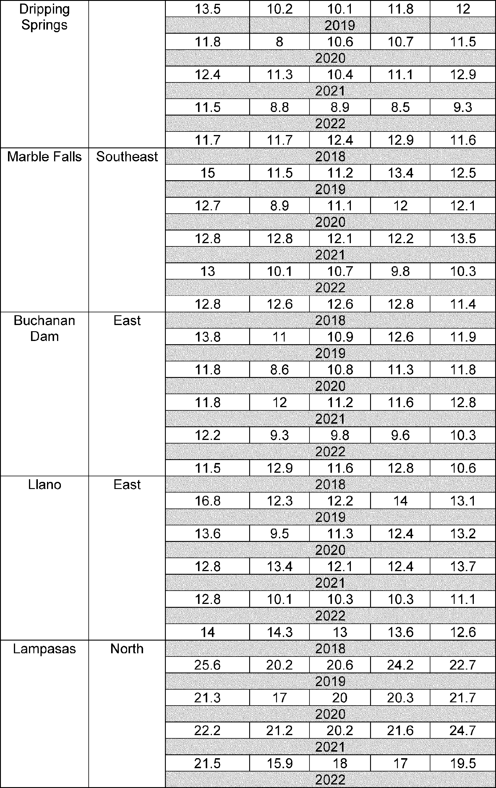
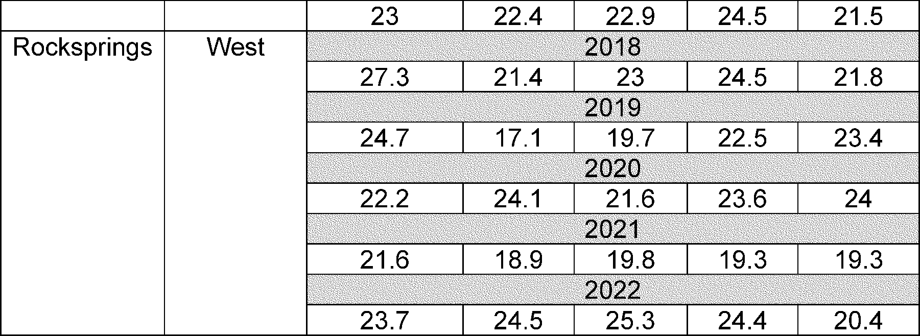
The petition states that, while the climate of the proposed Hickory Sands District AVA is generally the same as that of the surrounding regions during the growing season, diurnal temperature shifts are an important distinction. The proposed AVA has daily maximum temperatures similar to the surrounding regions but experiences significantly greater cooling after sunset due to its higher elevations and greater distance from the coastal regions of Texas. The following tables show the average monthly growing season diurnal temperature swings [20]
for the proposed AVA and the surrounding regions from 2018 to 2022.
( printed page 52581)
( printed page 52582)
( printed page 52583)
The data show that the proposed Hickory Sands District AVA has greater growing season diurnal temperature swings than the surrounding regions. Temperature swings within the proposed AVA are regularly at least 14 degrees greater than the regions to the south, east, and southeast, which have a large concentration of commercial viticulture. The differences between the proposed AVA and the regions to the north and west are less pronounced, but the petition notes that commercial viticulture does not occur in these regions. According to the petition, the nightly cooldown helps counteract the punishing daily heat during the grape ripening. In particular, cooler nighttime temperatures allow the grapes to maintain acidity while ripening and ensure favorable pH levels from harvested fruit.
Elevation
Elevations within the proposed AVA range from 1,500 feet to 1,980 feet. According to the petition, the average vineyard elevation within the proposed Hickory Sands District AVA is 1,717 feet. To the east and southeast, within the proposed Llano Uplift AVA, elevations average 983 feet. The petition states that the high elevations within the proposed AVA hasten and enhance the cooling of temperatures after the sun sets. As discussed previously, the lower nighttime temperatures relieve stress on the vines and allow the grapes to ripen while maintaining favorable acidity levels.
Comparison of the Proposed Hickory Sands District AVA to the Existing Texas Hill Country AVA
The Texas Hill Country AVA was established by T.D. ATF-318, which published in the
Federal Register
on November 29, 1991 (56 FR 60920). T.D. ATF-318 states that the AVA is a region of low mountains, hills, canyons, and valleys surrounded by flatter terrain. Soils are derived from limestone, sandstone, and granite and are generally calcareous.
The proposed Hickory Sands District AVA shares some of the major features of the established Texas Hill Country AVA. For example, the proposed AVA is considered part of the region known as the Texas Hill Country, as shown in a map produced by the Texas Parks and Wildlife and included in the petition as Exhibit 13. The petition also notes that the proposed AVA is similarly dominated by karst topography, where the land was shaped by the dissolution of water-soluble limestone and granite bedrock. As a result, the proposed AVA also has soils derived from sandstone and granite.
However, the proposed Hickory Sands District AVA also has distinctive features that set it apart from the larger Texas Hill Country AVA. For example, the exposed Precambrian rock formations in the proposed AVA are the oldest in Texas, whereas the rock formations in the surrounding established AVA are from the Cretaceous period and are several hundred million years more recent. Additionally, while the primary soils of the proposed AVA are from the Keese and Ligon soil series, the major soils of the established Texas Hill Country AVA are from the Tarrant—Oplin group and the Brackett—Eckrant—Real series. The proposed AVA also draws its water from the Hickory Aquifer, whereas most of the Texas Hill Country AVA gets its water from the Edwards—Trinity, Edwards, and Trinity Aquifers. Finally, the proposed AVA has average elevations that are 1,717 feet, compared to the average Texas Hill Country AVA, which has an average elevation of 1,000 feet.
Comparison of the Proposed Hickory Sands District AVA to the Proposed Llano Uplift AVA
The proposed Hickory Sands District AVA is located entirely within the northwestern portion of the proposed Llano Uplift AVA. Both proposed AVAs share several features, including karst topography with exposed Precambrian and Cambrian rock formations; neutral to slightly acidic sandy loam soils over bedrock of granite, limestone, gneiss, and schist; and hot growing season temperatures. However, within the proposed Hickory Sands District AVA, irrigation wells draw groundwater from only the Hickory Aquifer, whereas irrigation wells in the proposed Llano Uplift AVA also draw from the Ellenburger-San Saba Aquifer. Additionally, the petition states that irrigation wells in the proposed Hickory Sands District AVA are generally more productive than in the proposed Llano Uplift AVA. The petitioner provided a chart showing irrigation wells with yield rates at or exceeding 200 gallons per minute.[21]
There are 66 such wells within the proposed Hickory Sands District AVA, compared to four within the region of the proposed Llano Uplift AVA that is outside the proposed Hickory Sands District AVA.
Diurnal temperature swings also differentiate the proposed Hickory Sands District AVA from the proposed Llano Uplift AVA. Within the proposed Hickory Sands District AVA, the shifts are greater, even though the petition states that average growing season high temperatures in the two proposed AVAs are less than one degree different. The petition attributes the difference in diurnal temperature swings to elevation differences, as the average elevation of commercial vineyards in the proposed Hickory Sands District AVA is over 700 feet higher than the average elevation of
( printed page 52584)
vineyards within the proposed Llano Uplift AVA.
Finally, although both proposed AVAs contain Keese and Ligon “hickory sands” soils, these soils are more scattered and not as prevalent within the proposed Llano Uplift AVA as compared within the proposed Hickory Sands District AVA. According to the petition, the proposed Llano Uplift AVA also has extensive areas where granite outcroppings intrude upon the surface, leading to shallower soils than are found in the proposed Hickory Sands District AVA.
TTB Determination
TTB concludes that the petitions to establish the 2,096-square mile “Llano Uplift” AVA and the 193-square mile “Hickory Sands District” AVA merit consideration and public comment, as invited in this document.
Boundary Description
See the narrative boundary descriptions of the petitioned-for AVAs in the proposed regulatory text published at the end of this document.
Maps
The petitioners provided the required maps, and they are listed below in the proposed regulatory text. You may also view the proposed Llano Uplift AVA and Hickory Sands District AVA boundaries on the AVA Map Explorer on the TTB website, at
www.ttb.gov/regulated-commodities/beverage-alcohol/wine/ava-map-explorer.
Impact on Current Wine Labels
Part 4 of the TTB regulations prohibits any label reference on a wine that indicates or implies an origin other than the wine's true place of origin. For a wine to be labeled with an AVA name or with a brand name that includes an AVA name, at least 85 percent of the wine must be derived from grapes grown within the area represented by that name, and the wine must meet the other conditions listed in 27 CFR 4.25(e)(3). If the wine is not eligible for labeling with an AVA name and that name appears in the brand name, then the label is not in compliance and the bottler must change the brand name and obtain approval of a new label. Similarly, if the AVA name appears in another reference on the label in a misleading manner, the bottler would have to obtain approval of a new label. Different rules apply if a wine has a brand name containing an AVA name that was used as a brand name on a label approved before July 7, 1986. See 27 CFR 4.39(i)(2) for details.
If TTB establishes the proposed Llano Uplift AVA, its name, “Llano Uplift,” will be recognized as a name of viticultural significance under § 4.39(i)(3) of the TTB regulations (27 CFR 4.39(i)(3)). The text of the proposed regulation clarifies this point. Consequently, wine bottlers using “Llano Uplift” in a brand name, including a trademark, or in another label reference as to the origin of the wine, would have to ensure that the product is eligible to use the viticultural area's name “Llano Uplift.” The approval of the proposed Llano Uplift AVA would not affect any existing AVA, and any bottlers using “Texas Hill Country” as an appellation of origin or in a brand name for wines made from grapes grown within the Llano Uplift AVA would not be affected by the establishment of this new AVA. If approved, the establishment of the proposed Llano Uplift AVA would allow vintners to use “Llano Uplift,” “Texas Hill Country,” or both AVA names as appellations of origin for wines made from grapes grown within the proposed AVA, if the wines meet the eligibility requirements for the appellation.
If TTB establishes the proposed Hickory Sands District AVA, its name, “Hickory Sands District,” will be recognized as a name of viticultural significance under § 4.39(i)(3) of the TTB regulations (27 CFR 4.39(i)(3)). The text of the proposed regulation clarifies this point. Consequently, wine bottlers using “Hickory Sands District” in a brand name, including a trademark, or in another label reference as to the origin of the wine, would have to ensure that the product is eligible to use the viticultural area's name “Hickory Sands District.” The approval of the proposed Hickory Sands District AVA would not affect any existing AVA, and any bottlers using “Texas Hill Country” as an appellation of origin or in a brand name for wines made from grapes grown within the Hickory Sands District AVA would not be affected by the establishment of this new AVA. If approved, the establishment of the proposed Hickory Sands District AVA would allow vintners to use “Hickory Sands District,” “Texas Hill Country,” “Llano Uplift,” or two or three of these AVA names as appellations of origin for wines made from grapes grown within the proposed AVA, if the wines meet the eligibility requirements for the appellation. TTB is not proposing to make “Hickory Sands,” standing alone, a term of viticultural significance in order to allow for the use of truthful statements regarding the presence of “hickory sand” soils in vineyards on wine labels.
Public Participation
Comments Invited
TTB invites comments from interested members of the public on whether TTB should establish the proposed Llano Uplift and Hickory Sands District AVAs. TTB is interested in receiving comments on the sufficiency and accuracy of the name, boundary, and other required information submitted in support of the AVA petitions. With regards to the proposed Llano Uplift AVA, TTB is interested in comments on whether the evidence submitted in the petition regarding the distinguishing features of the proposed AVA sufficiently differentiates it from the existing Texas Hill Country AVA, in which the proposed AVA is located. TTB is also interested in comments on whether the geographic features of the proposed AVA are so distinguishable from the Texas Hill Country AVA that the proposed Llano Uplift AVA should not be part of the established AVA. Please provide any available specific information in support of your comments.
With regards to the proposed Hickory Sands District AVA, TTB is interested in comments on whether the evidence submitted in the petition regarding the distinguishing features of the proposed AVA sufficiently distinguishes it from the existing Texas Hill Country AVA and the proposed Llano Uplift AVA, both of which entirely encompass the proposed Hickory Sands District AVA. TTB is also interested in comments on whether the geographic features of the proposed Hickory Sands District AVA are so distinguishable from either the Texas Hill Country AVA or the proposed Llano Uplift AVA that the proposed Hickory Sands District AVA should not be part of either the established AVA or the proposed Llano Uplift AVA. Please provide any available specific information in support of your comments.
Because of the potential impact of the establishment of the proposed Llano Uplift and Hickory Sands District AVAs on wine labels that include the terms “Llano Uplift” or “Hickory Sands District” as discussed above under Impact on Current Wine Labels, TTB is particularly interested in comments regarding whether there will be a conflict between the proposed area names and currently used brand names. If a commenter believes that a conflict will arise, the comment should describe the nature of that conflict, including any anticipated negative economic impact
( printed page 52585)
that approval of the proposed AVAs will have on an existing viticultural enterprise. TTB is also interested in receiving suggestions for ways to avoid conflicts, for example, by adopting a modified or different name for the proposed AVAs.
Submitting Comments
You may submit comments on this proposal as an individual or on behalf of a business or other organization via the
Regulations.gov
website or via postal mail, as described in the
ADDRESSES
section of this document. Your comment must reference Notice No. 243 and must be submitted or postmarked by the closing date shown in the
DATES
section of this document. You may upload or include attachments with your comment. You also may request a public hearing on this proposal. The TTB Administrator reserves the right to determine whether to hold a public hearing.
Confidentiality and Disclosure of Comments
All submitted comments and attachments are part of the rulemaking record and are subject to public disclosure. Do not enclose any material in your comments that you consider confidential or that is inappropriate for disclosure. TTB will post, and you may view, copies of this document, the related petition and selected supporting materials, and any comments TTB receives about this proposal within the related
Regulations.gov
docket. In general, TTB will post comments as submitted, and it will not redact any identifying or contact information from the body of a comment or attachment. Please contact TTB's Regulations and Rulings Division by email using the web form available at
www.ttb.gov/contact-rrd, or by telephone at 202-453-2265, if you have any questions about commenting on this proposal or to request copies of this document, the related petition and its supporting materials, or any comments received.
Regulatory Flexibility Act
TTB certifies that this proposed regulation, if adopted, would not have a significant economic impact on a substantial number of small entities. The proposed regulation imposes no new reporting, recordkeeping, or other administrative requirement. Any benefit derived from the use of a viticultural area name would be the result of a proprietor's efforts and consumer acceptance of wines from that area. Therefore, no regulatory flexibility analysis is required.
It has been determined that this proposed rule is not a significant regulatory action as defined by Executive Order 12866, as amended. Therefore, it requires no regulatory assessment.
(a)
Name.
The name of the viticultural area described in this section is “Llano Uplift”. For purposes of part 4 of this chapter, “Llano Uplift” is a term of viticultural significance.
(b)
Approved maps.
The five United States Geological Survey (USGS) 1:100,000 scale topographic map used to determine the boundary of the viticultural area are as follows:
(1) Mason, Texas, 1985;
(2) Brady, Texas, 1985;
(3) Llano, Texas, 1992;
(4) Pedernales River, Texas, 1985; and
(5) Kerrville, Texas, 1985.
(c)
Boundary.
The Llano Uplift viticultural area is located in portions of Blanco, Burnet, Gillespie, Llano, Mason, McColloch, and San Saba Counties, in Texas. The boundary of the Llano Uplift viticultural area is as described as follows:
(1) The beginning point is on the Mason map at the intersection of US Highway 377 and an unnamed road known locally as Paloma Road, southwest of Long Mountain. From the beginning point, proceed east along US Highway 377 for 2.9 miles to a point east of Cutoff Mountain and due south of Haystack Mountain; then
(2) Proceed north in a straight line for 2.8 miles to the peak of Haystack Mountain; then
(3) Proceed northeast in a straight line for approximately 3.35 miles to the intersection of State Highway 1222 and an unnamed road known locally as Roble Drive; then
(4) Proceed northeast in a straight line for approximately 5.72 miles to the intersection of State Highway 1222 and an unnamed road known locally as Sandy Lane Road; then
(5) Proceed northeast in a straight line for approximately 1.24 miles to an unnamed road known locally as Flat Rock Road; then
(6) Proceed northeast in a straight line for approximately 1.94 miles to the intersection of U.S. Highway 87 and the shared McCulloch-Mason County line; then
(7) Proceed northeast in a straight line for approximately 6.85 miles, crossing onto the Brady map, to the intersection of the San Saba River and State Highway 71; then
(8) Proceed northeast in a straight line for approximately 1.32 miles to the intersection of two unnamed roads known locally as County Road 208 and Private Road 671; then
(9) Proceed northeast in a straight line for approximately 1.87 miles to the intersection of two unnamed roads known locally as Private Road 626 and Private Road 669; then
(10) Proceed east in a straight line for approximately 2.24 miles to an unnamed road known locally as County Road 212; then
(11) Proceed southeast in a straight line for approximately 6.21 miles, crossing onto the Mason map, to an unnamed road known locally as County Road 385, east of Deer Creek; then
(12) Proceed southeast in a straight line for approximately 1.27 miles to the intersection of two unnamed roads known locally as County Road 381 and County Road 373; then
(13) Proceed east along County Road 373 for approximately 4.5 miles, crossing onto the Llano map, to the road's intersection with an unnamed road known locally as West Farm-to-Market Road 501; then
(14) Proceed east along West Farm-to-Market Road 501 for approximately 12.9 miles to its intersection with Cherokee Creek; then
(15) Proceed easterly along Cherokee Creek for 10.6 miles to its intersection with an unnamed road known locally as West Farm-to-Market Road 501/Pontotoc Road; then
(16) Proceed east along West Farm-to-Market Road 501 for 3.8 miles to its intersection with an unnamed road known locally as State Highway 16/South Indian Avenue in Cherokee; then
(17) Proceed south-southeast in a straight line to the intersection of an unnamed road known locally as County Road 437 and Jackson Branch; then
(18) Proceed northeast in a straight line for 2.6 miles to its intersection with
( printed page 52586)
an unnamed road known locally as County Road 436; then
(19) Proceed southerly along County Road 436 for approximately 1.7 miles to its second intersection with the 1,500-foot elevation contour; then
(20) Proceed southeast in a straight line to the 1,600-foot elevation contour; then
(21) Proceed southeast in a straight line for 7.9 miles to the summit of Point Peak; then
(22) Proceed northeast in a straight line for 7.9 miles to the confluence of Fall Creek with Lake Buchanan; then
(23) Proceed counterclockwise along the shore of Lake Buchanan for a total of 67.4 miles to its intersection with an unnamed road known locally as Ranch Road 2341; then
(24) Proceed south along Ranch Road 2341 for 0.9 mile, circling Spider Mountain, to an unnamed road known locally as County Road 113; then
(25) Proceed east-southeast in a straight line for 2.9 miles to its intersection with the 1,360-foot elevation contour south of Council Creek; then
(26) Proceed southeast in a straight line for 4.5 miles to the intersection of two unnamed roads known locally as Ranch Road 2341 and State Highway 29 at the marked Fourmile Spring; then
(27) Proceed southwest in a straight line to its intersection with an unnamed road known locally as Hoover Valley Road, west of the marked landing strip; then
(28) Proceed southwest in a straight line for 6.3 miles to the summit of Backbone Mountain; then
(29) Proceed northeast in a straight line for 9.4 miles to the intersection of State Highway 281 and an unnamed road known locally as Park Road 4 South, south of Demarco; then
(30) Proceed south along State Highway 281 for 8.9 miles, crossing the Colorado River, to the highway's intersection with an unnamed road known locally as Old River Road in Marble Falls; then
(31) Proceed southwest in a straight line for 9.3 miles to its intersection with Pecan Creek north of the shared Llano-Blanco County line; then
(32) Proceed southwest in a straight line for 6.1 miles, crossing onto the Pedernales River map, to an unnamed road known locally as Smith West Ranch Road; then
(33) Proceed southwesterly along Smith West Ranch Road for 2 miles to its intersection with an unnamed road known locally as The Great Divide; then
(34) Proceed southeast in a straight line for 5.7 miles to the summit of Buffalo Peak; then
(35) Proceed southwest in a straight line for 5.8 miles to the confluence of the Pedernales River and North Grape Creek; then
(36) Proceed west-northwesterly along North Grape Creek for 15.1 miles to its intersection with an unnamed road known locally as Wahrmund-Ahrens Road; then
(37) Proceed north along Wahrmund-Ahrens Road for 1.5 miles to its intersection with an unnamed road known locally as Ranch Road 1631; then
(38) Proceed north along Ranch Road 1631 for 0.36 mile to its intersection with an unnamed road known locally as Ranch Road 1323; then
(39) Proceed west, then north along Ranch Road 1323 to its intersection with an unnamed road known locally as Andy Moor Mountain Road; then
(40) Proceed west-southwest in a straight line for 2.6 miles to its intersection with two unnamed roads known locally as Old Willow Road and OK Ranch Road; then
(41) Proceed westerly along Old Willow Road for 2 miles to its intersection with State Highway 16; then
(42) Proceed northwest in a straight line for 17.9 miles, crossing onto the Kerrville map, to the shared Mason-Gillespie County line; then
(43) Proceed west along the shared Mason-Gillespie County line and then along the shared Mason-Kimble County line for 22.9 miles to its intersection with the James River; then
(44) Proceed northeasterly along the James River for approximately 9.3 miles, crossing onto the Mason map, to the river's intersection with the marked pipeline; then
(45) Proceed northwest in a straight line for 15 miles to the beginning point.
(a)
Name.
The name of the viticultural area described in this section is “Hickory Sands District”. For purposes of part 4 of this chapter, “Hickory Sands District” is a term of viticultural significance.
(b)
Approved maps.
The 13 United States Geological Survey (USGS) 1:24,000 scale topographic map used to determine the boundary of the viticultural area are as follows:
(1) Long Mountain, TX., 1970;
(2) Grit, TX., 1970;
(3) Purdy Hill, TX., 1962;
(4) Spy Rock, TX., 1963;
(5) Fredonia, TX., 1962;
(6) Katemcy, TX., 1970;
(7) Voca, TX., 1963;
(8) Pecan Springs, TX., 1963;
(9) Pontotoc, TX., 1955;
(10) Fly Gap, TX., 1962, photorevised 1982;
(11) Mason, TX., 1967, photoinspected 1979;
(12) Turtle Creek, TX., 1968; and
(13) Sheep Run Creek, TX., 1968.
(c)
Boundary.
The Hickory Sands District viticultural area is located in portions of Llano, Mason, McCulloch, and San Saba Counties, in Texas. The boundary of the Hickory Sands District viticultural area is as described as follows:
(1) The beginning point is on the Long Mountain map at the intersection of US Highway 377 and the 1,748-foot elevation point, just west of benchmark 1,678. From the beginning point, proceed northwest in a straight line to the marked 1,705-foot elevation contour at the intersection of Big Bluff Creek and an unnamed, unpaved road; then
(2) Proceed northeast in a straight line to the 1,800-foot elevation contour; then
(3) Proceed easterly, then southeasterly, then northerly along the meandering 1,800-foot elevation contour to its intersection with an unnamed, unpaved road running perpendicular to the unnamed road known locally as Red Lane, northeast of the marked 1,844-foot elevation point; then
(4) Proceed northeast in a straight line to the marked 1,866-foot elevation point; then
(5) Proceed northeast in a straight line to the 1,900-foot elevation contour; then
(6) Proceed southerly, then northeasterly along the meandering 1,900-foot elevation contour, crossing onto the Grit map, and continuing along the 1,900-foot elevation contour to its intersection with an unnamed, unpaved road southeast of the marked “Spring;” then
(7) Proceed southeasterly, then easterly along the unnamed, unpaved road, passing another unnamed, unimproved road, to its intersection with a second unnamed, unpaved road south of the marked 1,908-foot elevation point; then
(8) Proceed southwesterly along the second unnamed, unpaved road to its intersection with Honey Creek; then
(9) Proceed southerly along Honey Creek to its intersection with State Highway 29; then
(10) Proceed southeasterly along State Highway 29 to its intersection with US Highway 377; then
(11) Proceed southeasterly along US Highway 377, crossing onto the Purdy Hill map, to the highway's intersection with US Highway 87; then
(12) Proceed northeast in a straight line to the marked 1,648-foot elevation point at the intersection of State Highway 386 and an unnamed road
( printed page 52587)
known locally as Old Katemcy Mason Road; then
(13) Proceed north along Old Katemcy Mason Road to the marked 1,692-foot elevation point; then
(14) Proceed northeast in a straight line past Little Willow Creek to the marked 1,842-foot elevation point; then
(15) Proceed east-southeast in a straight line to the marked 1,693-foot elevation point on an unnamed, light-duty road known locally as Blackjack Road; then
(16) Proceed northeast in a straight line, crossing onto the Spy Rock map, to the marked 1,653-foot elevation point on an unnamed road known locally as Thomas Road; then
(17) Proceed northeasterly in a straight line to the marked 1,629-foot elevation point at the intersection of two unnamed roads known locally as Spy Rock Road and Wagram Road; then
(18) Proceed northeast in a straight line, crossing onto the Fredonia map, and continuing in a straight line to benchmark 1,675 along State Highway 1222; then
(19) Proceed northwest in a straight line, crossing over the shared Mason-McCulloch County line and back onto the Spy Rock map, to the marked 1,602-foot elevation point along an unnamed road known locally as State Highway 224; then
(20) Proceed north in a straight line to the intersection of State Highway 734 and an unnamed road known locally as County Road 222; then
(21) Proceed northwesterly along State Highway 734 to its intersection with an unnamed road known locally as Private Road 661; then
(22) Proceed southwest in a straight line to the marked 1,613-foot elevation point; then
(23) Proceed southwest in a straight line to the marked 1,625-foot elevation point; then
(24) Proceed southwest in a straight line to the marked 1,610-foot elevation point along South Farm-to-Market Road 1851; then
(25) Proceed southwest in a straight line to the marked 1,713-foot elevation point at the intersection of an unnamed road known locally as Voca Road and State Highway 1222; then
(26) Proceed southwest in a straight line to the marked 1,774-foot elevation point along an unnamed road known locally as Old Katemcy Mason Road; then
(27) Proceed northwest along Old Katemcy Mason Road, crossing onto the Katemcy map, and continuing along the road to its intersection with State Highway 1222; then
(28) Proceed west-southwest along State Highway 1222 to its intersection with the 1,700-foot elevation contour; then
(29) Proceed southwest in a straight line, crossing the 1,750-foot elevation contour, to a fork in Dry Prong Katemcy Creek north of the marked 1,758-foot elevation point; then
(30) Proceed southwesterly along Dry Prong Katemcy Creek, crossing back onto the Grit map, and continuing along the creek to its intersection with an unnamed road known locally as Stark Road/A-H Road; then
(31) Proceed west, then northwest, along Stark Road to the marked 2,037-foot elevation point; then
(32) Proceed northwest in a straight line, crossing back onto the Katemcy map, to the marked 1,971-foot elevation point; then
(33) Proceed north-northeast in a straight line to the marked 1,823-foot elevation point; then
(34) Proceed northeast in a straight line to the marked 1,770-foot elevation point along State Highway 1222; then
(35) Proceed northeast in a straight line to the marked 1,801-foot elevation point; then
(36) Proceed northeast in a straight line to the marked “Quarry”; then
(37) Proceed northeast in a straight line to the intersection of US Highway 377 and an unnamed road known locally as Katemcy Road at the marked 1,716-foot elevation point; then
(38) Proceed northeast in a straight line to the marked 1,726-foot elevation point; then
(39) Proceed northeast in a straight line to the marked 1,669-foot elevation point at the intersection of two unnamed roads; then
(40) Proceed northeast in a straight line to the marked 1,645-foot elevation point west of Katemcy Creek; then
(41) Proceed northeast in a straight line, crossing back onto the Spy Rock map, to the marked 1,682-foot elevation point; then
(42) Proceed northeast in a straight line to the marked 1,618-foot elevation point along an unnamed road known locally as County Road 216; then
(43) Proceed north along County Road 216, crossing onto the Voca map, and continuing along the road to its intersection with State Highway 734; then
(44) Proceed northeast in a straight line to benchmark 1,495 along an unnamed road known locally as County Road 214; then
(45) Proceed northeast in a straight line to the intersection of two unnamed roads known locally as County Road 208 and Private Road 671, east of the marked “Quarry”; then
(46) Proceed northeast in a straight line to the marked 1,554-foot elevation point at the intersection of two unnamed roads known locally as Private Road 626 and Private Road 669; then
(47) Proceed east in a straight line to the marked 1,494-foot elevation point along an unnamed road known locally as County Road 212; then
(48) Proceed southeast in a straight line, crossing onto the Pecan Springs map, to the marked 1,642-foot summit; then
(49) Proceed south in a straight line to the marked 1,586-elevation point along an unnamed road known locally as County Road 220; then
(50) Proceed southeast in a straight line, crossing onto the Fredonia map, to the marked 1,629-foot elevation point; then
(51) Proceed southeast in a straight line to the marked 1,810-foot summit; then
(52) Proceed southeast in a straight line, crossing over the shared McCulloch-San Saba County line, to the marked 1,608-foot elevation point along an unnamed road known locally as County Road 385; then
(53) Proceed south along County Road 385 to the marked 1,659-foot elevation point; then
(54) Proceed southeast in a straight line to the marked 1,702-foot elevation point; then
(55) Proceed southeast in a straight line to the intersection of two unnamed roads known locally as County Road 373 and County Road 381; then
(56) Proceed southeast in a straight line to the marked 1,789-foot elevation point; then
(57) Proceed south in a straight line to the marked 1,804-foot summit; then
(58) Proceed east in a straight line to the marked 1,800-foot elevation contour; then
(59) Proceed generally east along the meandering 1,800-foot elevation contour, crossing onto the Pontotoc map, and continuing along the elevation contour to its intersection with an unnamed road known locally as West Farm-to-Market Road 501; then
(60) Proceed north along West Farm-to-Market Road 501 to the marked 1,882-foot elevation point; then
(61) Proceed northeast in a straight line to the marked 1,955-foot elevation point; then
(62) Proceed east in a straight line to the marked 1,794-foot summit; then
(63) Proceed northeast in a straight line to the marked 1,779-foot summit; then
(64) Proceed east in a straight line to the 1,700-foot elevation contour; then
(65) Proceed northerly, then generally east, then southerly along the meandering 1,700-foot elevation contour
( printed page 52588)
to its intersection with the shared San Saba-Llano County line; then
(66) Proceed southwest in a straight line to the marked 1,617-foot elevation point along an unnamed road known locally as Field Creek Lane; then
(67) Proceed southwesterly along Field Creek Lane to its intersection with an unnamed road known locally as State Highway 71 in the town of Field Creek; then
(68) Proceed west, then northwest along State Highway 71 to the marked 1,505-foot elevation point along an unnamed road known locally as County Road 513; then
(69) Proceed southwest in a straight line to the New Pontotoc Cemetery; then
(70) Proceed southwest in a straight line, crossing onto the Fredonia map, to the intersection of the North Fork of San Fernando Creek and Fly Gap Road near the marked 1,484-foot elevation point; then
(71) Proceed south along Fly Gap Road, crossing onto the Fly Gap map, and continuing along the road to its intersection with County Road 2618; then
(72) Proceed west along County Road 2618 to its intersection with an unnamed, light-duty road; then
(73) Proceed southeasterly along the unnamed, light-duty road to the marked 1,530-foot elevation point; then
(74) Proceed southwest in a straight line to the summit of Man Mountain; then
(75) Proceed west-southwest in a straight line to the marked Hanie Mine; then
(76) Proceed southwesterly in a straight line, crossing onto the Purdy Hill map, to the Ellison Cemetery along an unnamed, light-duty road known locally as Brockman Lane; then
(77) Proceed southwest in a straight line to the marked “Spring”; then
(78) Proceed south in a straight line to the marked 1,526-foot elevation point along an unnamed road known locally as Old Pontotoc Road; then
(79) Proceed west along Old Pontotoc Road to its intersection with the marked 1,555-foot elevation point and an unnamed road known locally as Behrens School Road; then
(80) Proceed south along Old Pontotoc Road, crossing onto the Mason map, and continuing along the road to its intersection with East State Highway 29 and an unnamed road known locally as Copperhead Road; then
(81) Proceed south along Copperhead Road to its intersection with the 1,500-foot elevation contour; then
(82) Proceed generally westerly, then southerly, then westerly along the meandering 1,500-foot elevation contour to a point due east of the 1,511-foot elevation point along unnamed road known locally as Ranch Road 1723; then
(83) Proceed west in a straight line to the 1,700-foot elevation contour; then
(84) Proceed north in a straight line to the marked 1,610-foot summit; then
(85) Proceed west in a straight line, crossing onto the Turtle Creek map, to the marked 1,801-foot summit; then
(86) Proceed north in a straight line to the marked 1,785-foot summit; then
(87) Proceed southwest in a straight line to the marked 1,728-foot summit; then
(88) Proceed northwest in a straight line to the marked 1,706-foot summit; then
(89) Proceed west in a straight line to Honey Creek; then
(90) Proceed northeasterly, then northwesterly, then northeasterly along Honey Creek, crossing onto the Grit map, to the creek's intersection with State Highway 377 at the marked 1,668-foot elevation point; then
(91) Proceed southwest, then northwest, along State Highway 377 to its intersection with an unnamed, light-duty road known locally as Old Junction Road; then
(92) Proceed southeast in a straight line, crossing onto the Turtle Creek map, to the terminus of an unnamed, unimproved road known locally as Lange Road; then
(93) Proceed southwest in a straight line, crossing onto the Sheep Run Creek map, to the intersection of Big Bluff Creek and the unnamed road known locally as Chimney Hollow Road; then
(94) Proceed northwest in a straight line to the marked 1,662-foot elevation point; then
(95) Proceed northwest in a straight line, crossing onto the Long Mountain map, to the marked 1,794-foot elevation point; then
(96) Proceed northeast in a straight line to the beginning point.
Signed: August 11, 2026.
Mary G. Ryan,
Administrator.
Approved: August 12, 2026.
Kevin M. Salinger,
Acting Assistant Secretary of the Treasury (Tax Policy).
Footnotes
1.
See Exhibit 1.8 to the petition, which is included in Docket TTB-2026-0005 at
www.regulations.gov.
20.
The petition notes that the diurnal temperature swings were calculated using daily differences between maximum and minimum temperatures, not a monthly average of mean temperatures.
Use this for formal legal and research references to the published document.
91 FR 52576
Web Citation
Suggested Web Citation
Use this when citing the archival web version of the document.
“Proposed Establishment of the Llano Uplift and Hickory Sands District Viticultural Areas,” thefederalregister.org (August 14, 2026), https://thefederalregister.org/documents/2026-16670/proposed-establishment-of-the-llano-uplift-and-hickory-sands-district-viticultural-areas.
 www.regulations.gov
 5 U.S.C. 553(b)(4)
 27 CFR part 4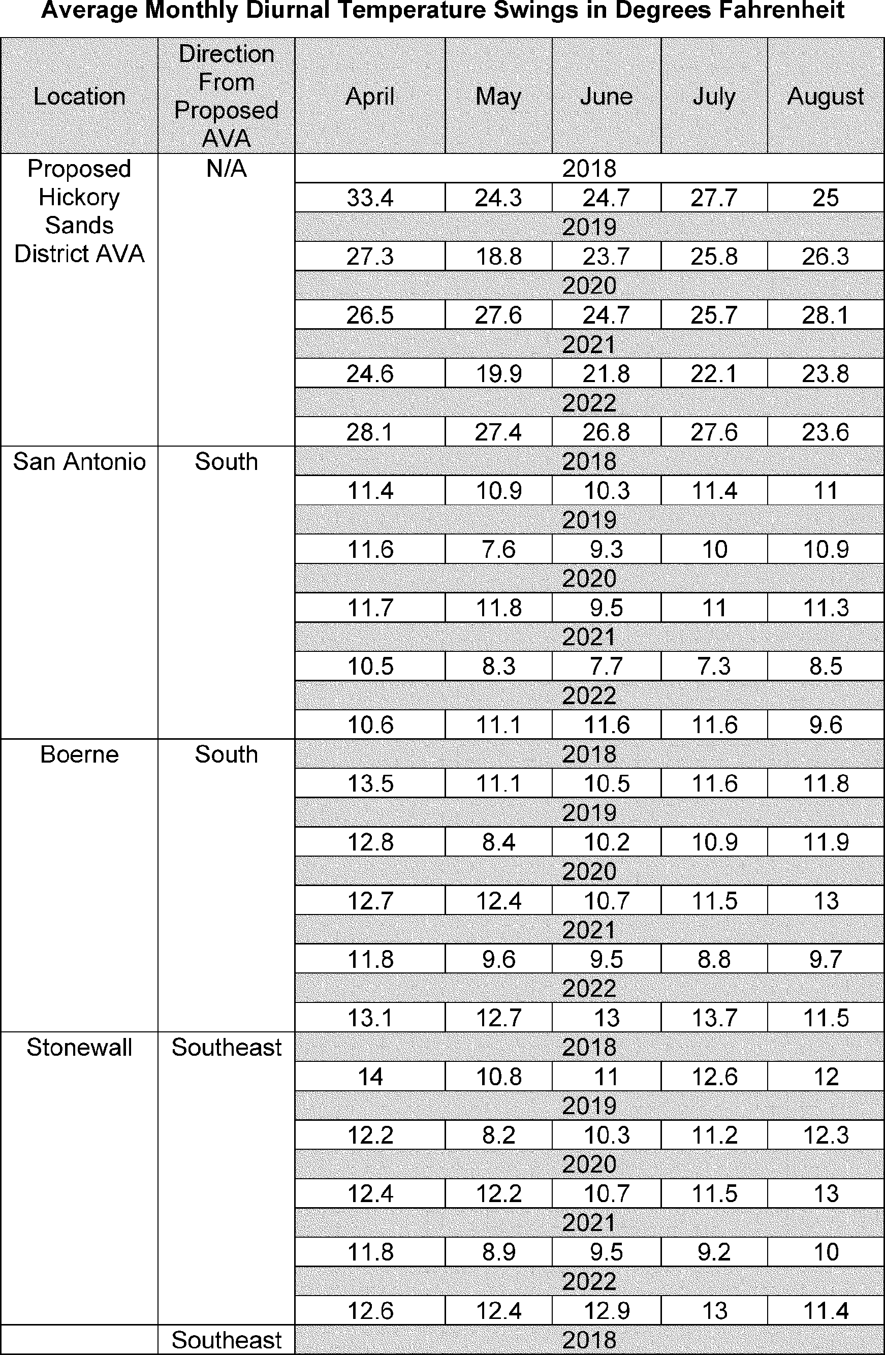
 www.ttb.gov/regulated-commodities/beverage-alcohol/wine/ava-map-explorer
 vintagetexas.com/archives/30940
 texashillcountry.com/texas-treasure-hunt-topaz
 www.conchovalleyhomepage.com/news/local-news/hickory-water-treatment-plant-expansion
 www.facebook.com/HickorySand
 aipg-tx.org/_docs/LlanoUpliftFieldGuide2016PostTripRevisionC.pdf
 www.fbgtx.org/DocumentCenter/View/4225/2020-Drinking-H2O-Quality-Report
 www.cosatx.us/departments-services/water-utilities/hickory
 ucranchesforsale.com/property/mcculloch-county-tx-hunting-ranch-home-for-sale